Walk #247: North Somercotes to Skegness
 |
 |
|
General Data
| Date Walked | 26/10/2002 |
| County | Lincolnshire |
| Start Location | North Somercotes |
| End Location | Skegness Lifeboat Station |
| Start time | 07.55 |
| End time | 17.00 |
| Distance | 24.4 miles |
| Description | This was a long but technically easy walk following the coast southwards to Skegness. |
| Pack | Today I carried my 30-litre Karrimor HotRock rucksack, which was filled with my packed lunch, waterproof coat, water bottle and a couple of spare shirts, together with the usual assortment of odds and ends. |
| Condition | I am very fatigued after this walk, which is no surprise considering the distance that I have walked. I put a Compeed plaster on the hotspot on my right foot that has been developing over the last couple of days, and this seems to have stopped it from developing into a blister. I also wore my Pennine-Way boots for this walk, as I washed and waxed my Karrimor boots this morning. |
| Weather | There were a couple of light drizzle showers first thing this morning, which caused me to have to put the hood up on my coat. After this the clouds parted and what followed was a day with nice sunny skies blemished with only occasional clouds. There was not much wind, which was a dramatic change to last night when it was blowing a gale outside and the van was rocking quite violently at times. All in all it was a lovely day for walking, |
| OS map | Landranger number 113 (Grimsby, Louth & Market Rasen) and Landranger number 122 (Skegness & Horncastle) |
 |
 |
|
 |
 |
|
Map of the walk
Maps courtesy of Google Maps. Route for indicative purposes only, and may have been plotted after the walk. Please let me have comments on what you think of this new format. For a detailed table of timings for this walk, please see the table file.
Notes
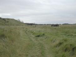
The caravan site that we stayed at last night was absolutely superb, and I was very tempted to stay longer. The walk beckoned, however, and I wanted to try and get a long distance done today. Once I left the site I soon joined a track that led back towards the sea, but this left me floundering slightly as I got lost. Once I reached the coast it was simply a case of walking southeastwards along a fairly boring stretch of beach and mud until I reached Saltfleet. I quite liked this little village, if only because it was a stark contrast to the beach walking!
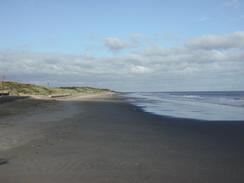
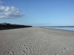
I soon regained the beach, and I then passed some ominous MOD warning signs, before the beach eventually became less muddier and more sandy. There was not much to see, excepting a few seals, and the beach was fairly deserted, and the main sign of people wee joggers running up and down the beach. One man in particular passed me several times in different directions, each time going so far that I could not see him before coming back half an hour later. I should think that he ran as far as I walked today, or so it seems!
Sam was waiting for me in Mablethorpe, and we had a quick look around this seaside town. Some donkeys were on the beach waiting for some customers, and I felt quite sorry for them, as they looked pitiful. Sam then left and I started off, only to get a phone call from her twenty minutes later - she had locked herself out of the van, and so she needed to meet me for my set of keys. I walked back towards her and she walked towards me, and I must admit that I was in quite a bad mood when she arrived. I handed the keys over, and then I set off once again, my plans for walking down to Gibraltar Point probably having been spoilt by the incident. I was familiar with the stretch of beach from Mablethorpe to Skegness as I had walked it before, and hence what was quite a boring beach walk became even more stupefying.
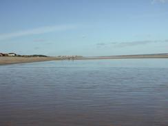
The area around Sutton on Sea is allegedly the driest in Britain, and I had no reason to disbelieve this as I walked along the beach. The clouds that had predominated this morning slowly lifted and the sun became visible for ever-longer periods, until eventually there was scarcely a cloud in the sky, which made the wet sand glisten beautifully.
The major feature to the north of Skegness was the large Butlins camp, which had its own monorail system running around it. The buildings looked identical to the ones that I had seen in Minehead - I wonder if the same style of building is used in all seaside Butlins camps? The Butlins camp was the first one that Billy Butlins opened, and is apparently still famous.
Skegness Pier was built in 1881 and was originally 1,843 feet long by 25 feet wide, making it the fourth longest pier in England. It cost 20,840 pounds to build (against an estimate of 18,000), and had a 700-seat theatre on the end of it. The majority of the pier was destroyed in a storm in 1978, and apparently it is now a shadow of its former self. I walked up and down the structure watching the waves lap below through gaps in the boards, and then I walked on to have a quick look around the lifeboat station. Sam was waiting for me by the clock tower in Skegness, and we then drove back north to the campsite for the night.
Directions
This walk starts off at the Lakeside Park in North Somercotes, on the A1031 road. Leave the caravan park and turn left to walk southeastwards down the A1031 for a short distance, before turning to the left down a track that heads past Salt Box Farm before reaching the flood bank. Once the flood bank is reached turn right and follow it southeastwards past Howden's Pullover and onwards until the flood bank ends at a junction with another flood bank by the outfall of a stream at Saltfleet Haven. Turn right and follow the flood bank upstream until the A1031 road is reached once more. Turn left to cross the stream by a bridge, and once on the other side turn left down a track that leads back to the shore.
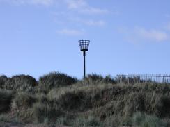
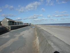
The shore here is part of an old army range, and so take heed of the warning notices as you follow the line of some sand dunes southeastwards. Follow the beach southeastwards to Mablethorpe, and then follow either the sea wall or the beach southwards, as it passes Mablethorpe, Trusthorpe and Sutton on Sea. The sea wall from Mablethorpe eventually ends at the car park below Cob Hill at TF 5418 7854, and from where the beach has to be followed. After three and a half miles the sea wall starts again at Chapel Point, just to the north of Chapel St Leonards.
In Chapel St Leonards you can continue walking along the beach or head inland as I did to find a local watering hole. If you do divert into the town head inland along The Pullover road, and then turn left to follow South Road southwards. Once you reach an old pub (the White House) turn right down a driveway into a caravan park that heads eastwards back to the beach. Once on the beach turn right and proceed southwards once more as the sea wall has disappeared again. As Ingoldmells is approached a funfair becomes visible, and the seawall restarts.
Pass Ingoldmells Point and continue southwards past the highly visible Butlins Holiday Village, complete with its own monorail system. As Seathorpe is approached the seawall ends once more and the beach has to be joined for a short distance until the northern outskirts of Skegness is reached. Here join the sea wall once more and follow it south, passing under the pier and onwards for a couple of hundred yards to the lifeboat station.
Once the pier is reached in Skegness continue on for a few hundred yards to the lifeboat station, and then turn to the right up a road to a roundabout with a clock tower in the middle, where this walk ends.
Distances
| From | To | Distance (m) | Ascent (ft) | Descent (ft) |
|---|---|---|---|---|
| North Somercotes | Mablethorpe | 9.5 | 59 | 69 |
| Mablethorpe | Sutton On Sea | 2.6 | 46 | 46 |
| Sutton On Sea | Chapel St Leonards | 6.4 | 10 | 10 |
| Chapel St Leonards | Skegness Lifeboat Station | 5.9 | 105 | 105 |
This makes a total distance of 24.4 miles, with 220 feet of ascent and 230 feet of descent.
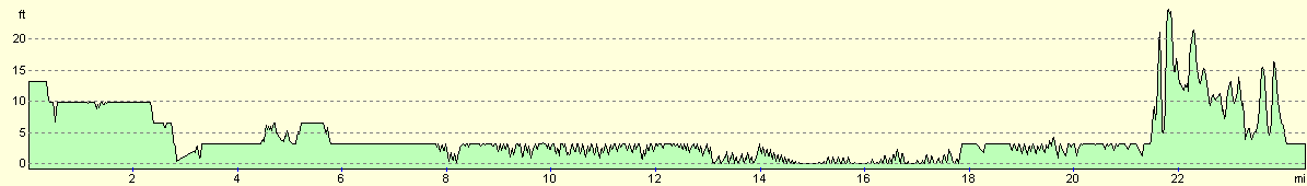
For more information on profiles, ascents and descents, see this page
Accommodation
We stayed at the Skegness Sands caravan park, Winthorpe Avenue, Skegness PE25 1QZ, telephone 01754 761484. This site cost us nine pounds and ninety-five pence for the night, and was nice and clean which made a change from some recent sites. This site was a site that I would come to again if I was in the area.
Disclaimer
Please note that I take no responsibility for anything that may happen when following these directions. If you intend to follow this route, then please use the relevant maps and check the route out before you go out. As always when walking, use common sense and you should be fine.
If you find any information on any of these routes that is inaccurate, or you wish to add anything, then please email me.
All images on this site are © of the author. Any reproduction, retransmissions, or republication of all or part of any document found on this site is expressly prohibited, unless the author has explicitly granted its prior written consent to so reproduce, retransmit, or republish the material. All other rights reserved.
Although this site includes links providing convenient direct access to other Internet sites, I do not endorse, approve, certify or make warranties or representations as to the accuracy of the information on these sites.
And finally, enjoy your walking!
This walk was mentioned in the following routes:
| My walk around the coastline of Britain |
Nearby walks
| # | Title | Walk length (miles) |
|---|---|---|
| 180 | Mablethorpe to Skegness | 15.6 |
| 246 | Pyewipe to North Somercotes via Grimsby and Cleethorpes | 18.8 |
| 248 | Skegness to Gibraltar Point | 4.8 |
|
|

|