Walk #246: Pyewipe to North Somercotes via Grimsby and Cleethorpes
 |
 |
|
General Data
| Date Walked | 25/10/2002 |
| County | Humberside, Lincolnshire |
| Start Location | Pyewipe |
| End Location | North Somercotes |
| Start time | 08.38 |
| End time | 15.57 |
| Distance | 18.8 miles |
| Description | This was a long walk, initially though the docks of Grimsby which was followed by the seafront at Cleethorpes and then a long walk along seawalls to near Donna Nook. |
| Pack | Today I carried my 30-litre Karrimor HotRock rucksack, which was filled with my packed lunch, waterproof coat, water bottle and a couple of spare shirts, together with the usual assortment of odds and ends. |
| Condition | For the first time in several days I felt that I could not really walk much further at the end of this walk. I was generally fatigued and quite low on energy due to not having ate very much, but the biggest problem was the fact that the hotspot on the ball of my left foot was getting worse and more painful for me to walk on. I will have to Compeed this tomorrow to try and protect it as I am intending to walk a long way. |
| Weather | The weather today started off cloudy with a slight wind, but as I approached Humberston it started to rain steadily. This was followed by ten minutes of absolute torrential downpour, during which I managed to hide in a caravan site's toilet block until it calmed down. Rain continued for about twenty minutes after this before finally petering out, to be replaced with a stronger wind. The afternoon was quite glorious at times, with a mainly clear sky overhead and only a few clouds, which was a dramatic difference to this morning. |
| OS map | Landranger number 113 (Grimsby, Louth & Market Rasen) |
 |
 |
|
 |
Map of the walk
Maps courtesy of Google Maps. Route for indicative purposes only, and may have been plotted after the walk. Please let me have comments on what you think of this new format. For a detailed table of timings for this walk, please see the table file.
Notes
After the walk through the heavy industry yesterday afternoon, I was looking forward to having a slightly more scenic walk today. Unfortunately first I had to get to and through Grimbsy, which meant yet more road walking, which was not good on my feet. These have been suffering for a couple of days now, and blisters are forming on them in a nasty way, so I could do without yet more road plodding. In one of the docks to the west of Grimbsy I was surprised to see a large area literally filled to the brim with new Toyota cars. A car transporter was moored at the dock, and obviously all these cars had just come off it. The car transporter itself was an ugly brute of a ship that I dare anyone to say looked pretty - it was a classic example of function-only design.
I had intended to attempt to walk around the Fish Dock in Grimsby, using the lock gates to get over the entrance. For this reason instead of following roads to the south of the dock I headed along through a series of fish wharves and past endless warehouses to try and get towards the 350-foot high tower that dominates the docks. The tower was built in 1852 to store water, which could be used to hydraulically open and close the lock gates, and is of a lovely design. This was the first large fishing harbour that I have passed through on this trip, and I was amazed by how busy it was. People were going about everywhere, moving crates full of fish and ice from one place to another. I passed a large factory making ice; something that had not occurred to me would be needed, but is obvious when you think about how they pack the fish. Unfortunately I soon discovered that I could not cross the lock gates, and so I was forced to head back to try to skirt south around the southern edge of the docks.
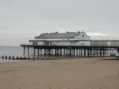
Eventually I managed to find a road that took me past New Clee Station and Grimsby football ground, which was literally squeezed in between the houses, and eventually reached Cleethorpes. The promenade took me southeastwards past the short, stumpy and frankly undistinguished pier, and when this ended I took a cycle path onwards to the southeast, eventually reaching the little village of Humberston Fitties. As I was walking through the caravan park in the village a tremendous rainstorm came over, and I went into the site's toilets to get out of the worst of it. Unfortunately this was not wholly successful as the roof of the toilet block had holes in it, but it was still far better than being outside in the downpour.
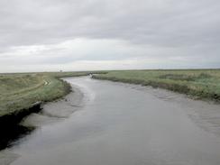
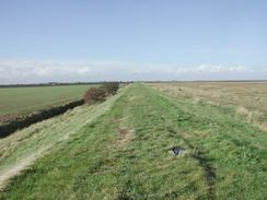
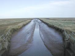
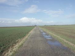
After about ten minutes the downpour ended, and I could restart the walk by joining the footpath that follows the flood bank southeastwards towards Tetney Lock. Once I reached a steam I had intended to turn right to walk to Tetney Lock to cross the stream, but when I reached the stream it became clear that I could cross a bridge a short distance to the left, although this was on private land and was not connected to any footpaths. Once across the bridge I followed the flood banking past Tetney Haven and on to Northcoates Point and the car park at Horse Shoe Point, where I rejoined the public footpath.
When I got to Somercotes Haven I was greeted with red flags flying over the Donna Nook RAF bombing range. I did not fancy continuing along the footpath past the flags, and so I turned to the right down a track. At Pye's Farm a farmer asked me what I was doing, and when I explained he said that you are allowed to walk past the red flags on the range as long as you keep to the footpath. Instead of sending me back, he allowed me to continue on, and I soon joined the road that headed south into the village of North Somercotes. I stopped at the shop, where the lady serving me kindly gave me a donation for the charity, and I then walked southeastwards for the last mile to the campsite, where Sam was waiting for me.
Directions
This walk starts off at a roundabout at grid reference TA258110, near a power station in Pyewipe. Follow the road eastwards; fairly son it curves to the right and ends at a roundabout with the A180 road. Turn to the left and follow the A180 eastwards; there is no pavement, but immediately to the south of the dual carriageway is a local access road, which was a much safer walk. The A180 crosses the entrance to a dock on a bridge, before reaching a roundabout on the other side. Here I turned to the left to try and walk through Grimbsy Docks; I would advise against this unless you want a look around, and therefore continue straight on along the A180 for a few hundred metres until the road becomes single carriageway, and then turn to the left along a local road that curves to the right to head eastwards to New Clee Station.
Follow the road as it skirts the railway line eastwards, and just before it ends turn left to cross the railway line via a footbridge and gain access to the seawall on the other side. Turn right and follow the promenade that runs alongside the seawall southeastwards as it passes through Cleethorpes and past the pier. Once the promenade ends near the leisure centre continue on along a footpath and cycle path, which runs alongside a little narrow-gauge railway. Once Humberston Fitties is reached continue on along the beach until a caravan park is reached, and then turn right through the caravan park along a track that leads out to the flood bank. Turn left and walk southeastwards for a couple of miles until the mouth of the Louth Canal is reached.
Turn left and walk along the flood bank for a few yards to a bridge over the canal, and one on the other side turn left and walk along the flood bank to Tetney Haven and Northcoates Point. Continue on along the flood bank as it passes the ruins of an old airfield, not mostly levelled, until Horse Shoe Point is reached. Here the footpath is rejoined, and it can be followed southeastwards to Grainthorpe Haven and Somercotes Haven. This is the northwestern edge of the Donna Nook RAF bombing range, but apparently you can keep on the footpath even if the red flags are flying. Continue on along the flood bank until a car park is reached near Stonebridge, and then turn right to head south down the road for a little less than two miles. When the road ends at a T-junction turn to the left along another road, and follow it as it curves to head southwards through North Somercotes to meet the A1031 road. Turn left along the A1031 road and follow it southeastwards for about a mile until Lakeside Park is reached on the left, where this walk ends.
Distances
| From | To | Distance (m) | Ascent (ft) | Descent (ft) |
|---|---|---|---|---|
| Pyewipe | Humberston | 7.1 | 282 | 285 |
| Humberston | North Somercotes | 11.7 | 89 | 82 |
This makes a total distance of 18.8 miles, with 371 feet of ascent and 467 feet of descent.
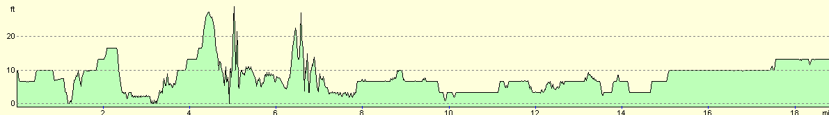
For more information on profiles, ascents and descents, see this page
Accommodation
We stayed at the excellent Lakeside Park, North Somercotes, Near Louth, Lincolnshire, LN11 7RB, Tel. 01507 358315, or email lakeside@donamott.com or see ten website at www.donamott.com. This site was very well run and was exceedingly clean and tidy, particularly when compared to the one we stayed at last night, The site cost us 2 pounds and twenty-five pence for the night, as they gave us a super pitch for nothing as we were doing a charity event. This was very kind of them, and saved us about sixteen pounds. The little money we paid was to pay for the electricity hook-up, which is fair enough.
Disclaimer
Please note that I take no responsibility for anything that may happen when following these directions. If you intend to follow this route, then please use the relevant maps and check the route out before you go out. As always when walking, use common sense and you should be fine.
If you find any information on any of these routes that is inaccurate, or you wish to add anything, then please email me.
All images on this site are © of the author. Any reproduction, retransmissions, or republication of all or part of any document found on this site is expressly prohibited, unless the author has explicitly granted its prior written consent to so reproduce, retransmit, or republish the material. All other rights reserved.
Although this site includes links providing convenient direct access to other Internet sites, I do not endorse, approve, certify or make warranties or representations as to the accuracy of the information on these sites.
And finally, enjoy your walking!
This walk was mentioned in the following routes:
| My walk around the coastline of Britain |
Nearby walks
| # | Title | Walk length (miles) |
|---|---|---|
| 242 | Easington to Skeffling via Spurn Head | 14.8 |
| 243 | Skeffling to Paull | 18.9 |
| 245 | Barton-Upon-Humber to Pyewipe | 23.7 |
|
|

|