Walk #400: Porthmadog to Pwllheli
 |
 |
|
General Data
| Date Walked | 31/03/2003 |
| County | Gwynedd |
| Start Location | Porthmadog |
| End Location | Pwllheli |
| Start time | 08.50 |
| End time | 16.50 |
| Distance | 20.4 miles |
| Description | This was a very enjoyable walk, with some nice deserted beaches to walk along and some great views back over Snowdonia. |
| Pack | Today I carried my 30-litre Karrimor HotRock rucksack, which was filled with my packed lunch, waterproof leggings, water bottle and a couple of spare shirts, together with the usual assortment of odds and ends. |
| Condition | I feel absolutely fine after this walk, and I did not have any major problems at all. I had no trouble with my left knee, which I am extremely thankful for, and both of my ankles were fine. |
| Weather | Today was an absolutely beautiful day, with lovely sunshine and very little cloud to bother me. The wind had died down from yesterday, and it was quite warm. Unfortunately it does not look as though it will last, as the forecast is for some heavy rain and showers to sweep down from the over overnight. This is the first rain that we will have had for some time, and whilst the gardens may have need of some rain I certainly do not. |
| OS map | Landranger number 124 (Dolgellau & Porthmadog) and Landranger number 123 (Lleyn Peninsula) |
 |
 |
|
 |
 |
|
Map of the walk
Maps courtesy of Google Maps. Route for indicative purposes only, and may have been plotted after the walk. Please let me have comments on what you think of this new format. For a detailed table of timings for this walk, please see the table file.
 |
 |
|
Notes
I was rather hesitant about doing this walk, as my left knee had been aching all night and had woken me up once or twice. I sprayed it quite liberally with Deep Heat this morning, and fortunately it did not give me any bother. This may have had something to do with the fact that here were not many ascents or descents, but whatever the reason, I am glad.
On another good note, a few miles into today's walk I reached the 3,000 mile mark for the entire trip. I think that this is quite an amazing milestone to reach, and I find it slightly overwhelming - if you had told me five years ago that I would be able to walk this far in a single trip, then I would not have believed you.
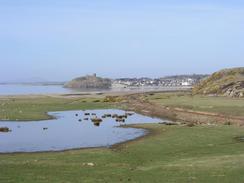
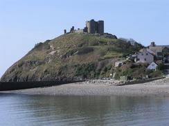
I quite liked Criccieth, and the town was quite clean and tidy as I walked through it and under the castle. I passed one of the famous homemade ice cream shop, but I rather amazingly resisted the temptation to go in and buy one. The castle is quite an impressive ruin. It was actually built by the Welsh in the early thirteenth century, but after the defeat of King Llewelyn in 1282 Edward I obtained it. it remained in English hands until 1407, when Owain Glyndwr's army sacked it in the last Welsh independence struggle. The map clearly shows a footpath heading west out of the town along the seafront befoe heading inland along the Afon Dwyfor, but this footpath was shut due to erosion after less than half a kilometre, and I therefore had to walk inland to the A497 road and follow that westwards. The first section of road to Llanystumdwy had a pavement, but this ended at the village so I diverted along the quieter roads through the village, passing the Lloyd George Museum on the way. I had hoped that the pub may have been open so that I could nip in for a drink, but unfortunately it was not. When the road through the village met the A497 once more the pavement restarted, but it soon ended and dumped me back onto the road once more.
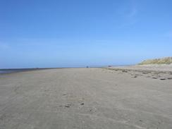
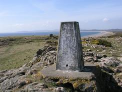
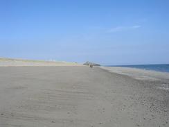
To get off the road I walked along a track along the western bank of the Afon Wen, under the railway and onto the beach. This allowed me access to the holiday village, which a track led through to get me to the headland at Pen-ychain. I sat down on a large concrete base beside the trig point to have a rest, with some absolutely lovely views available out to sea. This was followed by a long beach walk westwards, making for an absolutely superb walk the beach was nearly deserted, and I listened to a play on radio 4 as I walked along the firm sand. The play was set in Edinburgh and was about a woman changing her life on reaching 30, and this made me feel how my life changed for the better when I met Sam in Edinburgh two and a half years ago.
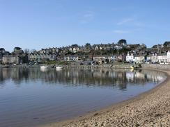
By the time that I reached Pwllheli Sam had still not arrived, and so I decided to walk on and around the promontory to Carreg yr Imbill, which extended the walk slightly, although it was hardly a classic section of walk. It is nice to think that despite the few problems that I had yesterday I could still manage to do quite a long walk today, although it was over some quite easy and unchallenging terrain. Pwlhelli is quite nice, and the promenade around the harbour towards the station was clean and tidy, although the area behind was hardly classic.
I met Sam at the western end of the road beside South Beach in the town. She had been chatting to some nice people in a house next door to where we had parked, and indeed they gave us a donation, which was very kind of them. Unfortunately about half an hour after I finished a man came out from the house that we were outside called Arley, and asked us to move in a tone that was far from conciliatory and not a million miles away from angry. He really upset Sam, so as she moved the van (to about ten yards away on the other side of the road) I went back to have a word with him. I do not mind being asked to move on, but his attitude was really not on - a kind word would have worked wonders, and I can understand that some people may not like Mervan being parked outside their house. I tried to be fairly conciliatory, and told him that he had upset Sam, but he just started ranting and walked away. The attitude of the man beggared belief - and I am really quite peeved. So I would therefore like to award that man - who was in the house called Arley - the second Raspberry award of the trip for being unnecessarily rude and arrogant.
After this we were both in a rather unhappy and slightly disconsolate mood, and it is a shame that a day that started so well has to be spoilt in such an unnecessary way. I cannot understand why people resort to being rude when it is not necessary.
Directions
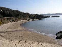
This walk starts off at the Ffestiniog Railway Station in Porthmadog. Leave the station and turn left to walk northwestwards along the A487 road towards the centre of the town. After a couple of hundred yards turn left along a road that heads past Woolworths and starts to climb uphill, and when the top of the hill is reached turn left along another road that heads downhill into Borth-y-Gest. Walk around the little and very attractive harbour, and shortly after the road passes a car park it ends. When it ends continue straight on along a footpath that initially heads through some sand dunes before splitting into several different paths. Head along these westwards, aiming for the beach that leads south to the point at Ynys Cyngar. Walk around the point and then walk west along the Black Rock Sands, until it ends at cliffs by Craig Ddu.
Just before the cliffs start turn right and walk through a caravan park to a road. Follow this road northwards until a track leads off to the left and heads uphill and around the northern side of Craig Ddu. The track descends down the western side and then heads towards and over the railway line. The path follows the northern side of the railway line, at one point squeezing through a rock cutting beside the line. As it nears Criccieth the footpath crosses over to the southern side of the railway line, and continues on until it ends at a road on the eastern side of Criccieth. Turn left down this road and follow it along the seafront and then up past the castle. Head downhill past a series of hotels, and when the road turns to the right follow it northwards over the railway line (the footpath marked on the OS map going westwards along the coast was shut due to erosion when I walked the route; this may reopen in the future).
When the A497 is reached turn left to walk westwards along it. After about a mile take a road that leads off to the right and which heads through the village of Llanystumdwy. Pass the Lloyd George museum and cross the bridge over the river, and follow the road around until it ends at the A497 road to the west of the village. Turn right to head westwards along the A497, passing the junction with the B4354 road and, a mile later, crossing a bridge over the Afon Wen. Immediately on the western side of the bridge turn left down a track that follows the western bank of the river, passing under the railway line before it ends at a beach.
Turn right to walk southwestwards along the beach. Head up a slipway that leads into the holiday village and then walk along the edge of the low cliffs through the village. This soon becomes a track that leads southwards around the edge of the cliffs until the trig point at the headland at Pen-ychain is reached. From there drop down off the cliffs and walk westwards along an absolutely superb stretch of beach for a few miles before it turns to head south by the north breakwater at Pwllheli. At the top of the breakwater join a roundabout, and then follow the road that leads northwards from the roundabout. When the northern edge of the harbour is reached turn left to walk along a nice little promenade until the station is reached.
A few yards beyond the station turn left to head south down another road, and then turn left along another series of roads that lead past the lifeboat station and enter a caravan park before reaching the end of the south breakwater. Head back through the caravan park and then join the beach at the southern side of the point, which can be followed westwards through Pwllheli, and this walk ends when the promenade ends.
I would like to thank Chris Walker, who gave me the following information about an alternative (and better) route out of Porthmadog to Borth-y-Gest beach:
Leave the Ffestiniog Railway station in Porthmadog and turn left over the bridge (in the direction of the town centre). As soon as you have crossed the bridge, turn left and follow the far side of the harbour wall past the Tourist Information Centre, and the Canalfon (a fairly large and modern community centre) and on past the Harbour Master's little office. The Pencai pub does good food and there is also a small bistro/cafe, called the Mariners Cafe, in the same square that offers outside tables or simply an ice cream. Between this cafe and the yacht club, you will find a steep set of concrete steps (83 in all!). Climb these and turn left at the top. This will bring you out onto a road; after about 100 yds walk up the hill, the terrace on your left finishes and you are rewarded with a fantastic view looking inland over the harbour and the Ffestiniog station and onto Snowdonia beyond. These are views that would be missed on your route from Woollie's to Borth-y-Gest. If you have ever read Bill Bryson's 'Notes from a Small Island', you will find that he has a bad experience on the Ffestioniog Railway but forgives Porthmadog when he discovers this view! Continue along this road for about another half mile, passing a large refurbished nursing home on your right (the old cottage hospital) and, when the 'dead end' road ends, there is a short series of steps that you drops you gently down to the eastern end of Borth-y-Gest beach - at the spot that photo P20033310806 was taken from. Continue as per your instructions!
Distances
| From | To | Distance (m) | Ascent (ft) | Descent (ft) |
|---|---|---|---|---|
| Porthmadog | Criccieth | 6.5 | 679 | 656 |
| Criccieth | Pen-ychain Point | 6.3 | 413 | 407 |
| Pen-ychain Point | South Beach, Pwllheli | 7.6 | 157 | 184 |
This makes a total distance of 20.4 miles, with 1249 feet of ascent and 1247 feet of descent.

For more information on profiles, ascents and descents, see this page
Accommodation
We parked Mervan on the road beside the South Beach in Pwllheli, although please make sure that you do not park outside the house called Arley.
Disclaimer
Please note that I take no responsibility for anything that may happen when following these directions. If you intend to follow this route, then please use the relevant maps and check the route out before you go out. As always when walking, use common sense and you should be fine.
If you find any information on any of these routes that is inaccurate, or you wish to add anything, then please email me.
All images on this site are © of the author. Any reproduction, retransmissions, or republication of all or part of any document found on this site is expressly prohibited, unless the author has explicitly granted its prior written consent to so reproduce, retransmit, or republish the material. All other rights reserved.
Although this site includes links providing convenient direct access to other Internet sites, I do not endorse, approve, certify or make warranties or representations as to the accuracy of the information on these sites.
And finally, enjoy your walking!
This walk was mentioned in the following routes:
| My walk around the coastline of Britain |
Nearby walks
| # | Title | Walk length (miles) |
|---|---|---|
| 398 | Fairbourne to Harlech | 17.8 |
| 399 | Harlech to Porthmadog | 15.2 |
| 401 | Pwllheli to Rhiw | 18.5 |
|
|

|