Walk #401: Pwllheli to Rhiw
 |
 |
|
General Data
| Date Walked | 01/04/2003 |
| County | Gwynedd |
| Start Location | Pwllheli |
| End Location | Rhiw |
| Start time | 10.07 |
| End time | 18.08 |
| Distance | 18.5 miles |
| Description | This was a long and quite frustrating day, with the worst weather for weeks and footpaths that either did not exist or disappeared in fields. |
| Pack | Today I carried my 30-litre Karrimor HotRock rucksack, which was filled with my packed lunch, waterproof leggings, water bottle and a couple of spare shirts, together with the usual assortment of odds and ends. |
| Condition | I feel absolutely fine after this walk, and I have no major problems to report. I used a knee brace for the first time today on my left knee, and this gave me no problems. |
| Weather | At about five this morning it really started to rain hard, and apparently some parts of North ales had a centimetre of rain in an hour. There was a strong northwesterly wind associated with the rain, and this really made the van rock. Fortunately the same wind also blew the rain away, and what followed was a mixture of sunshine and showers, during which the temperature varied considerably. |
| OS map | Landranger number 123 (Lleyn Peninsula) |
 |
 |
|
 |
 |
|
Map of the walk
Maps courtesy of Google Maps. Route for indicative purposes only, and may have been plotted after the walk. Please let me have comments on what you think of this new format. For a detailed table of timings for this walk, please see the table file.
Notes
I woke up this morning to high winds and some driving rain, the combination of which made me quite hesitant to start. The weather forecast was for it to get better so I decided that it would be better to delay the start so that I would miss the worst of it. Fortunately this worked but I still got soaked in the four heavy showers that followed during the day. The weather this morning was absolutely atrocious, and we both looked out of the van at the white horses being whipped up by the wind.
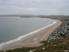
The maps shows a long stretch of sand leading westwards from Pwllheli along Traeth Crugan to the little headland near Carreg y Defaid, and I started by walking along this beach. Unfortunately the tide was too high so I had to divert to the track that runs immediately behind the beach. The high tide also meant that I could not walk around the headland, and so I had to follow the A499 road into Llanbedrog. The climb up from Llanbedrog to the path around Trwyn Llanbedrog was up some very steep and in places disordered steps, but the views from the top were tremendous although I did not get to see the tin man on the top (there was a different sculpture, however). I had to walk quite a way inland to find a path down from the top of the hill but eventually I found a quite precarious one that was fine.
I stopped for lunch at the Vagnol Arms in Abersoch, where I met Sam and stopped for a while. We shared a basket of chips whist we had a game of pool, which actually relaxed me slightly. After we left I the pub I said goodbye to Sam, and decided that instead of walking along he roads around Abersoch I would walk along the beach. Unfortunately the tide had not gone out far enough, so I ended up doing a slippy but enjoyable scramble over rocks to get the beach that led south to Machroes.
The footpaths in this area are very frustrating - some that I needed to use today were shown on the map but I could find no trace of them on the ground, and others had entrances into fields but no exits. This left me floundering around in several fields, trying to find the way out to no avail. This made it quite hard to try to stick to the most coastal route, a I could not find the footpaths required, and eventually I gave up and picked the nearest route that I could easily find.
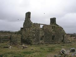
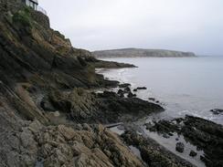
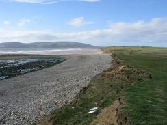
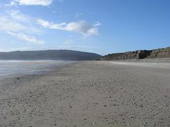
The weather today was also annoying. I am very glad that I missed the heavy rain first thing this morning, but unfortunately this was replaced with a mixture of sunshine and heavy showers. There was also quite a strong north-westerly wind, and this was quite annoying at times, particularly when I was walking along the beach at Hell's Mouth. This was an extremely strong headwind that made walking difficult, and I noticed with envy the people who were being blown in the other direction. The name of the beach was most apt, and the waves were really being whipped up by the wind. The earth cliffs behind the beach are quite high and are being very rapidly eroded by the waves, with some towering pinnacles that are not going to remain for long. Indeed the road at the eastern end has been closed due to erosion, and a new diversion is being constructed through the trees nearby. I was unsure about how to get off the beach at the western end as the cliffs were quite high, and a local man told me that I could either scramble up at a slumped section of cliff and join a footpath, or I could walk further along the beach to a ruined cottage and take a lane up from there. I chose the latter as the tide was out enough to allow it, although it did involve walking over some large boulders strewn over the foreshore. Care would have to be taken on the walk past Hell's Mouth, as the cliffs behind are quite high without many escape routes, so it would be easy to get trapped.
Tomorrow I shall round the corner of the Lleyn Peninsular, and started the walk northeastwards towards Caernarfon, which I should reached in about three days.
Directions
This walk starts off by the South Beach in Pwllheli. Walk westwards along the beach (called Traeth Crugan), or if the tide is high then walk along the track that runs behind the beach. As the beach curves southwards to meet the headland near Carreg y Defaid head inland along a track that ends at the A499 road. Turn left to walk southwestwards down the A499 until a road leads off to the left by a petrol station. Take this road and when it nears the church in Llanbedrog turn left down a road that reaches the beach in the village.
At low tide it is apparently possible to walk right around the headland of Tywyn Llanbedrog; if the tide is high then walk to a slipway on the right and climb up to a track. Turn left along the track and when it ends at the boathouse walk around it to the eastern side, where a footpath leads up some steep steps to the top of the hill. At the top of the hill a footpath skirts around the top of the hill, and unfortunately you have to walk quite a way inland (to just before a track starts), where a footpath leads steeply downhill before ending at a surfaced single-lane road. Turn left down this road and follow it until it ends at the northern end of the beach.
Turn right and walk southwards along the beach in front of The Warren. When the lifeboat station is reached turn right and join the A499 road to cross over the Afon Soch to enter Abersoch. Turn left to walk along the seafront through the village and if the tide is low enough then join he beach to walk around the town and reach the beach to the south. walk south down this beach for about a mile until you reach Machroes; walk past the main part of the village towards Penrhyn Du, but before this is reached climb up off the beach beside a concrete sluice to join a track. Head uphill along this track southwards, and when it becomes a public road turn left by a cottage along a footpath that leads across a field to the farm at Cim.
From here my directions are sparse; I was trying to follow the paths closest to the sea but unfortunately the signage of paths was very bad, and some signed paths disappeared in the middle of fields. Basically I tried to make my way to the farm at the southern tip of the road at grid reference 298 239 from where a footpath led off northwestwards, but even when I got there I could not find the path. Basically make your way to the southeastern end of the beach at Hell's Mouth; I will not explain how I got there as it did not necessarily follow footpaths and frankly confused me silly.
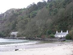
Join the beach at Hell's Mouth and walk northwestwards along the beach for over three miles until it ends. You then have two choice; you can either scramble up a low section of cliff to join a footpath near grid reference 241283, or if the tide is low then you can continue along the beach, crossing an area of boulders to reach a ruined cottage (there were also some small fishing boats here when I passed). From this cottage a green lane heads uphill before ending at a road. Turn left up this road and follow it uphill until it reaches the crossroads in the village of Rhiw, where this walk ends.
Distances
| From | To | Distance (m) | Ascent (ft) | Descent (ft) |
|---|---|---|---|---|
| Pwllheli | Abersoch | 7.2 | 663 | 633 |
| Abersoch | Rhiw | 11.3 | 1453 | 906 |
This makes a total distance of 18.5 miles, with 2116 feet of ascent and 1539 feet of descent.
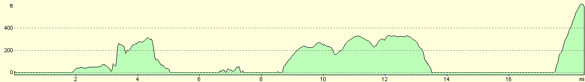
For more information on profiles, ascents and descents, see this page
Accommodation
We parked for the night by the roadside in Rhiw, which was convenient as it was where I finished the walk, but unfortunately there were no facilities.
Disclaimer
Please note that I take no responsibility for anything that may happen when following these directions. If you intend to follow this route, then please use the relevant maps and check the route out before you go out. As always when walking, use common sense and you should be fine.
If you find any information on any of these routes that is inaccurate, or you wish to add anything, then please email me.
All images on this site are © of the author. Any reproduction, retransmissions, or republication of all or part of any document found on this site is expressly prohibited, unless the author has explicitly granted its prior written consent to so reproduce, retransmit, or republish the material. All other rights reserved.
Although this site includes links providing convenient direct access to other Internet sites, I do not endorse, approve, certify or make warranties or representations as to the accuracy of the information on these sites.
And finally, enjoy your walking!
This walk was mentioned in the following routes:
| My walk around the coastline of Britain |
Nearby walks
| # | Title | Walk length (miles) |
|---|---|---|
| 400 | Porthmadog to Pwllheli | 20.4 |
| 402 | Rhiw to Tudweiliog | 17.8 |
|
|

|