Walk #402: Rhiw to Tudweiliog
 |
 |
|
General Data
| Date Walked | 02/04/2003 |
| County | Gwynedd |
| Start Location | Rhiw |
| End Location | Tudweiliog |
| Start time | 09.11 |
| End time | 16.50 |
| Distance | 17.8 miles |
| Description | This should have been quite a nice day, but it was slightly annoying as I could not really walk around the end of the peninsular. |
| Pack | Today I carried my 30-litre Karrimor HotRock rucksack, which was filled with my packed lunch, waterproof leggings, water bottle and a couple of spare shirts, together with the usual assortment of odds and ends. |
| Condition | I feel absolutely fine after this walk, and have no major problems to report. This is to be expected, however, as the walk was far from strenuous. |
| Weather | After a slightly wet day yesterday today was far better, with lots of sunshine and some cloud, from which there was a little bit of drizzle when I sat down for lunch. The worst thing about today's weather was the wind, which was strong and gusting at times and chilled me when I was exposed to it. |
| OS map | Landranger number 123 (Lleyn Peninsula) |
 |
 |
|
 |
 |
|
Map of the walk
Maps courtesy of Google Maps. Route for indicative purposes only, and may have been plotted after the walk. Please let me have comments on what you think of this new format. For a detailed table of timings for this walk, please see the table file.
 |
Notes
Today I rounded the corner of the Lleyn Peninsular, which is a bit of a milestone as it allows me to start making progress northeastwards up to Caernarfon. The map of Wales that gets generated by the scripts on my website is starting to look remarkably complete now that I have reached the western tip of the Lleyn Peninsular.
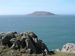
As I was walking down the road westwards towards Aberdaron I was surprised to meet Sam coming up the hill towards me. We had arranged to meet in the town, but she had come up to met me. We descended together, and I started wondering if it was worth waiting for twenty minutes for one of the pubs to open, but instead we went to a charming little cafe, the Big Kitchen. This thirteenth century building was used as a feeding station for pilgrims making the trip to Bardsey Island, which I saw a little later on. Apparently three pilgrimages to Bardsey Island were worth one to Rome, which shows how important a place it was. We both had scones with jam and cream, and relaxed in this beautiful little village.
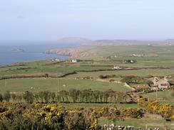
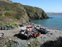
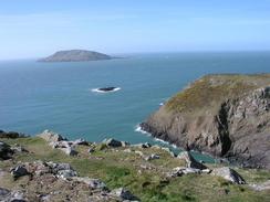
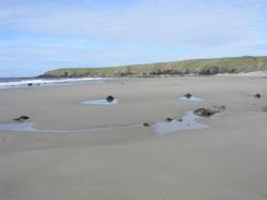
The path leading to Pen y cil was a lovely stretch of cliff top path, and I enjoyed the walk around this considerably. The path was very good underfoot and easy to follow, which always helps make a walk easier. Unfortunately the eastern side of the little headland does not have a cliff top path so this scenic section was followed by a walk inland to the path at Porth Widlin, to the west of Llangwnnadl. I resisted the temptation to make the diversion down to Porth Oer, which as so-called Squeaky Sands - the particles of sand are shaped in such a way that when they are dry and tread on them they squeak - I visited a similar beach to the southwest of Melbourne in Australia. The next stretch of path was very nice again, but the path was not very well defined in places so I basically followed the coast around. The beach at Porth Colmon (called Traeth Penllech) was nice, and I enjoyed my little stroll along it. I was slightly concerned about whether I could get off the beach at the northern end, but fortunately it was easy to get up the low cliff along one of the valleys that cut into it. Walking along the beach was a good idea, as it stopped me from having to walk up and down all these little valleys along the cliff top paths.
Very near the end of the walk I climbed up out of a little valley to see a bald head of someone sitting on the ground. As I got closer I discovered to my amusement that it was not a head but another part of a man's anatomy doing some horizontal jogging. I diverted away slightly to give them some privacy, but they still looked up and watched me go past. This is the first time I have seen this on this trip, although I expect it may get more frequent as the warmer weather starts.
I like days like today when the walk ends at the campsite; I could have walked further, but I am quite glad that I did not. As much as anything else it allows Sam to relax a little more, as she can watch a DVD or just do nothing in the morning after I set off. This campsite is quite nice, and it is conveniently near the cost. Sam cut my hair tonight for only the second time since I started the walk - I am in need of short hair now that the weather is turning warmer. I can only hope that having my hair cut has not had the same result on me that it had on Samson when Delilah did it! Sam has also used the opportunity to get a couple of loads of washing done, and the van looks like a Chinese laundry as a result.
My sister and brother in law are coming to visit on Saturday and Sunday, and to we are going to try to stay near them in Snowdonia. To enable this I have decided that unless the weather is unsuitable then I shall walk up Snowdon on Saturday. Ideally I want to get to the base of the mountain last thing on Friday so that I can get an early start on Saturday and reach the summit before the crowds. I want to start my walk up the mountain from Caernarfon, and so I have to hurry to get there. This will mean a long walk tomorrow, and so I hope that it is good weather.
Directions
This walk starts off at the crossroads in the village of Rhiw. From the crossroads follow the road that heads southwestwards for a little under a mile until it reaches the farm at Penarfynydd. When the farm is reached take a bridleway that heads off to the right, heading northwestwards for a hundred yards before curving to the left to head westwards for the same distance to a road. Join the road and follow it as it heads westwards through Ysgo until it reaches a telephone box at a crossroads. At the crossroads turn left and follow this road westwards for a couple of miles into the village of Aberdaron.
In Aberdaron join the B4413 road and use it to cross over the Afon Daron. When the road swings around to the right on the other side of the river take a road off to the left opposite the post office, and follow this road uphill to the west. After a few hundred yards as the gradient flattens a footpath heads off to the left. This footpath skirts the edge of the cliffs, descending into and then climbing out of Porth Meudwy before reaching the point at Pen y Cil. From here I took a footpath northwards through the National Trust land until it reached a footpath that led off westwards (these paths are hard to distinguish on the map, and are indistinct on the ground in places).
Follow the footpaths westwards towards Carreg Fawr and on towards the road at Gwyddel. When this road is reached turn right along it for a mile until a little chapel is reached at Cwrt. A path leads off to the left of the chapel and heads northwards until it ends at another road by a farm. Turn left along this road and follow it for several miles as it heads northeastwards, paralleling some distance away from the coast. When a T-junction is reached at Methlem turn left along another road that reaches another T-junction at Ty-hen; at this junction turn left to head northeastwards. When the road reaches grid reference 186318 a footpath heads off to the left and heads towards the coast.
When this footpath reaches the coast turn right and follow another a footpath northeastwards along the top of the cliffs. The path is indistinct in places but is easy to follow; just keep to the seaward side of the turf walls. The path descends down to Porth Colman and here I chose to walk along the beach of Traeth Penllech to its northern end; if the tide is high a footpath continues along the top of the cliffs. Contnue on past Penrhyn Melyn and follow the path as it descends down into Porth Ychain and up the other side. This walk ends at the campsite at Penrallt, which is reached from a track that heads inland to the right a few hundred yards northeast of Porth Ychain.
Distances
| From | To | Distance (m) | Ascent (ft) | Descent (ft) |
|---|---|---|---|---|
| Rhiw | Aberaeron | 4.1 | 154 | 735 |
| Aberaeron | Tudweiliog | 13.7 | 1729 | 1654 |
This makes a total distance of 17.8 miles, with 1883 feet of ascent and 2389 feet of descent.
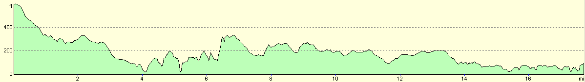
For more information on profiles, ascents and descents, see this page
Accommodation
We stayed at the campsite at Penrallt, Tudweiliog, Pwllheli, Gwynedd LL53 8PB. This site was very near to the footpath around the coast, and the owners were very nice. They gave us the pitch for free as we were on a charity walk, but it normally costs seven pounds fifty pence. They can be contacted on (01758) 770654.
Disclaimer
Please note that I take no responsibility for anything that may happen when following these directions. If you intend to follow this route, then please use the relevant maps and check the route out before you go out. As always when walking, use common sense and you should be fine.
If you find any information on any of these routes that is inaccurate, or you wish to add anything, then please email me.
All images on this site are © of the author. Any reproduction, retransmissions, or republication of all or part of any document found on this site is expressly prohibited, unless the author has explicitly granted its prior written consent to so reproduce, retransmit, or republish the material. All other rights reserved.
Although this site includes links providing convenient direct access to other Internet sites, I do not endorse, approve, certify or make warranties or representations as to the accuracy of the information on these sites.
And finally, enjoy your walking!
This walk was mentioned in the following routes:
| My walk around the coastline of Britain |
Nearby walks
| # | Title | Walk length (miles) |
|---|---|---|
| 401 | Pwllheli to Rhiw | 18.5 |
|
|

|