Walk #403: Tudweiliog to Clynnog Fawr
 |
 |
|
General Data
| Date Walked | 03/04/2003 |
| County | Gwynedd |
| Start Location | Tudweiliog |
| End Location | Clynnog Fawr |
| Start time | 10.10 |
| End time | 18.52 |
| Distance | 19.5 miles |
| Description | This was a highly enjoyable but strenuous walk with some lovely scenery and what was probably the highest climb of the trip so far. |
| Pack | Today I carried my 30-litre Karrimor HotRock rucksack, which was filled with my packed lunch, waterproof leggings, water bottle and a couple of spare shirts, together with the usual assortment of odds and ends. |
| Condition | I am quite tired after this walk, but that is to be expected after such a long walk. I have had no major problems and no real aches or pains, and I could easily have walked further if I had needed to. |
| Weather | There were quite a few showers first thing this morning, and I decided to delay the start until after the rain had stopped. What followed was a dry day, for which I am thankful, and as the day went on the cloud slowly dissipated and was replaced with sunshine, although cloud remained on the hills. Fortunately there was not much wind, and this helped make the walk more enjoyable. |
| OS map | Landranger number 123 (Lleyn Peninsula) |
 |
 |
|
 |
 |
|
Map of the walk
Maps courtesy of Google Maps. Route for indicative purposes only, and may have been plotted after the walk. Please let me have comments on what you think of this new format. For a detailed table of timings for this walk, please see the table file.
Notes
I had another late start today, and again this was due to the weather. The forecast had been for the weather to get better last night, but instead it deteriorated, and when I woke up this morning I opened the blinds and was greeted with the sight of some showers. The forecast stated that these were to end, and so I used the opportunity of having power to Mervan to do some more work on my website. By nine I had done all the urgent work and it was still raining, so for only the second time on the rip I played a computer game for half an hour. This relaxed me considerably, and by ten the rain had stopped, and fortunately my strategy worked, as it did not rain again all day.
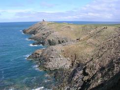
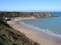
By the time that I reached the tower at the end of the little headland near Carreg Ddu I was getting quite hungry, and even though I had not covered many miles I was in need of a rest - probably another negative about having a late start. There is a pub marked on the map near Porth Dinllaen, and this led me to find a lovely little pub and village at the base of the cliffs. The pub, which is called Ty Coch, was closed (it was due to open every day the next week), but I am still glad that I went down as it allowed me to find a lovely beach, which I waked along before making my way back onto the cliff top path that led eastwards to the headland at Penrhyn Nefyn and making my way into the little town of Nefyn. In Nefyn I found a pub called the Sportsman, which I entered and had a quick couple of pints. There were lots of people in the pub watching the ring from Aintree, and I just sat in a corner as I supped the pints and read a paper that had been on the bar.
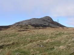
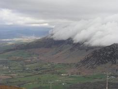
The views from the climb up to the Bwlch yr Eifl were very good, and before I got too high I could see Anglesey to my left and to my right I could see over the other side of the Lleyn Peninsular to the mountains of Snowdonia. Unfortunately as I got higher I started entering a cloud layer, the cloud being formed as the wind carried moist air against the hillside, pushing it up and cooling it, which leads to condensation and cloud formation. My mind went back to my A-level geography course and terms such as 'environmental lapse rate' and 'adiabatic lapse rate', and it was nice to see such theories actually occurring in front of my eyes. At one stage my head was in this newly formed cloud, but if I knelt down I could see underneath it.
I met Sam in Trefor and had a rest for twenty minutes whilst we chatted. As it was late in the day I considered stopping for the day in the village, but I knew that if I wanted to reach Snowdon Ranger tomorrow then I would have to walk further. Fortunately the last three or four miles of the walk was not very strenuous and involved walking along a main (but fortunately not too busy) road.
Unfortunately the late start also meant a very late finish, and I believe that this was probably the latest finish of the entire trip so far. I am quite glad that I did the extra three or four mile at the end, however, as it has moved me on considerably and made the walk over the next couple of days more flexible. Unfortunately it also had a down side; I was due to meet my parents tonight and they met Sam at Clynnog Fawr at about six, but by the time that I arrived hey had moved on. This rather upset me even though I shall probably see them tomorrow night - I wish that they could have held on for another half hour.
By the time that I reach Caernarfon tomorrow I shall have a decision to make. My itinerary does not include a climb up Snowdon (because by its very nature it is not on the coast). If it looks as though the weather will be nice on Saturday then I shall start walking down the A4085 towards Snowdon Ranger, which is the route that I shall take up. If the weather looks as though it will not be suitable, then I will continue the walk up towards Bangor and the crossing over to Anglesey.
Directions
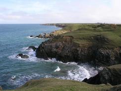
This walk starts off at a campsite by the coast to the west of Tudweiliog. Head back to the coast and then turn right to follow the cliff top path northeastwards. The path is quite easy to follow although it is indistinct in places, and can be followed for many miles until it approached a golf course at Borth Wen. The path then follow the coast all the way around the edge of the golf course around the headland that leads up to Carreg Ddu. On the eastern side of the headland a track leads down to the lifeboat station, and if the tide is out then a path can be followed around the base of the cliff to a few little houses and a pub at Porth Dinllaen. From here walk along the beach around until a slipway leads uphill beside some toilets. By the toilets a path heads uphill to the left onto the top of the cliffs. If the tide is high then simply follow the footpath from Carreg Ddu around the top of the cliffs until the slipway is reached.
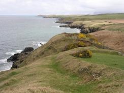
Follow the cliff top path eastwards to the headland at Penrhyn Nefyn; in places this was very overgrown with gorse, and the path was narrow in a couple of places as the cliff had partially eroded it away. From this headland the path starts to head inland as a road leads up from the beach below, and when the path ends at the road continue straight on the rough the town until it ends at a main road. Turn left along this road for a sort distance until it ends at a roundabout with the A497 road in Nefyn.
Turn left to follow the B4417 road northeastwards out of the town for about a mile, and when you reach a cottage on the left take a footpath that heads off northeastwards, passing a ruined hotel at Pisty and farms at Cefnydd and Cilau. At Cilau take a footpath that heads uphill in a more easterly direction towards Bwlch, and after a few hundred yards this joins a bridleway that heads northeastwards before ending at a car park for the Porth y Nant centre. From this centre a broad track leads uphill northeastwards, crossing the Bwlch yr Eifl between two hills before nearing an aerial at the top, which is sitting in an old quarry. Do not follow the track into the quarry but take a footpath that heads downhill, roughly following some power lines downhill. This path joins a green lane that heads straight downhill and ends at a bend in a road. Turn left down this road and head downhill once more into Trefor.
At a road junction turn right to head through the village. Cross a stream and when this road end at a T-junction turn left along a road that heads eastwards for a mile before ending at the A499 road. Turn left to head northeastwards along the A499 for under four miles towards Clynnog Fawr, where this walk ends. I made a little diversion on this last stretch down a road that heads in a little loop to the west of the main road, near Bryn-yr-Eryr.
Distances
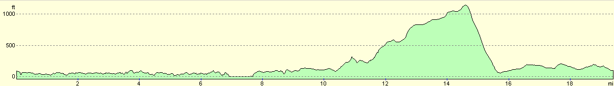
| From | To | Distance (m) | Ascent (ft) | Descent (ft) |
|---|---|---|---|---|
| Tudweiliog | Nefyn | 9.6 | 1148 | 1112 |
| Nefyn | Trefor | 6.2 | 1289 | 1352 |
| Trefor | Clynnog Fawr | 3.7 | 328 | 299 |
This makes a total distance of 19.5 miles, with 2765 feet of ascent and 2763 feet of descent.
For more information on profiles, ascents and descents, see this page
Accommodation
We spent the night in the car park of the Coach Inn in Clynnog Fawr, a nice pub that we had a drink or two in this evening. The pub is situated very near to the church in the village.
Disclaimer
Please note that I take no responsibility for anything that may happen when following these directions. If you intend to follow this route, then please use the relevant maps and check the route out before you go out. As always when walking, use common sense and you should be fine.
If you find any information on any of these routes that is inaccurate, or you wish to add anything, then please email me.
All images on this site are © of the author. Any reproduction, retransmissions, or republication of all or part of any document found on this site is expressly prohibited, unless the author has explicitly granted its prior written consent to so reproduce, retransmit, or republish the material. All other rights reserved.
Although this site includes links providing convenient direct access to other Internet sites, I do not endorse, approve, certify or make warranties or representations as to the accuracy of the information on these sites.
And finally, enjoy your walking!
This walk was mentioned in the following routes:
| My walk around the coastline of Britain |
Nearby walks
| # | Title | Walk length (miles) |
|---|---|---|
| 400 | Porthmadog to Pwllheli | 20.4 |
| 401 | Pwllheli to Rhiw | 18.5 |
| 402 | Rhiw to Tudweiliog | 17.8 |
|
|

|