Walk #398: Fairbourne to Harlech
 |
 |
|
General Data
| Date Walked | 29/03/2003 |
| County | Gwynedd |
| Start Location | Fairbourne |
| End Location | Harlech |
| Start time | 09.00 |
| End time | 16.22 |
| Distance | 17.8 miles |
| Description | This was a fairly uninteresting walk, without much to really recommend it. It was a combination of road and beach walking, and although I entered Snowdonia today it was not the most scenic walk that I have done recently. |
| Pack | Today I carried my 30-litre Karrimor HotRock rucksack, which was filled with my packed lunch, waterproof leggings, water bottle and a couple of spare shirts, together with the usual assortment of odds and ends. |
| Condition | I feel absolutely fine after this walk, and I have no major problems to report. |
| Weather | Today started off quite cloudy, although even from the start the sun was attempting to break through. We have had none of the promised overnight rain that has obviously missed us, although the wind was quite chilly first thing. As the day went on the cloud started to break up, and for the last couple of hours I walked under sunny skies. |
| OS map | Landranger number 124 (Dolgellau & Porthmadog) |
 |
 |
|
 |
 |
|
Map of the walk
Maps courtesy of Google Maps. Route for indicative purposes only, and may have been plotted after the walk. Please let me have comments on what you think of this new format. For a detailed table of timings for this walk, please see the table file.
 |
Notes
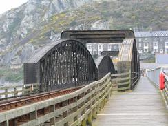
This was a far from exceptional day, the highlight of which was the crossing of the Barmouth Bridge. This bridge has a pedestrian footpath and cycle path along its eastern edge, from which I got some lovely views of the Mawddach Estuary. The majority of the bridge is quite low to the water, and it caused British Rail massive problems in the nineteen eighties when a marine worm bored into the piles beneath the bridge, substantially weakening it. For a period only light Diesel Multiple Units could use the line and heavy locomotive-hauled trains were banned, but fortunately BR bit the bullet and repaired the bridge at massive cost. I was quite fortunate that the tollbooth at the northern (Barmouth) was shut, so I did not need to pay the sixty pence it costs to cross the bridge - although it is hardly expensive. Sam commented that the road toll bridge five or six miles up the estuary charges only forty pence for a car, to which I replied that I was not going to walk ten miles there and back just to save twenty pence!
In Barmouth there was a sign advertising the three peaks race. This is not the normal from of this race, which involves competitors driving madly between Snowdon, Scafell Pike and Ben Nevis, but a far more leisurely and skilful one. The race starts at Barmouth, where the competitors have to sail to Caernafon before cycling to the base of Snowdon, running up to the top and back again to their bikes, when they cycle to Barmouth. From there they sail to near Scafell Pike, and repeat the manoeuvre to the top of England's highest peak, before sailing on to Fort William ready to tackle Ben Nevis. In the process they sail 389 miles, cycle 29 miles, run 59 miles and have an ascent of 14,500 feet. This is a major marathon, and one that must be an amazing achievement even to finish, yet alone win!
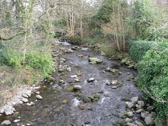
I stopped off for lunch at the Ysgethin Inn in Tal-y-bont, which was quite a nice little pub situated right beside the river. I had not had a lunchtime drink for a while, and so I sopped and listened to Radio 4 whilst I relaxed and had a couple of pints. I was therefore in a much more merry state when I left the pub, although this slowly wore off as the afternoon went on. It is yet another example of how the longer days allow me to take a much more relaxed approach to the walk than was the case a couple of months ago in winter, and I an exceedingly glad that this is the case, as the lack of time pressures makes the walk much more enjoyable.
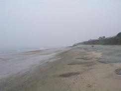
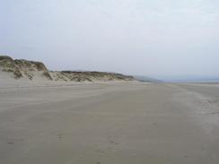
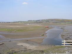
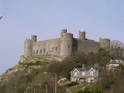
I decided to walk up the beach in front of the Morfa Dyffryn sand dunes as far as Shell Island, from where I would walk back inland. Unfortunately this was not as easy as I had been expecting, and the tracks that led through the dunes (some were even surfaced) appeared to be a complex maze. As I was walking along and getting increasingly frustrated at my lack of ability to keep even an easterly course, I received a phone call from Sam. She told me that on a narrow section of road to the south of Harlech Mervan had been hit by a white van coming in the other direction. There had been no major impact, but the driver's side wing mirror was badly damaged. This put me in a bad mood, and I got increasingly frustrated for what seemed like and age before I finally reached the large aerial at the Llanbedr airfield. Unfortunately the area was fenced off with dire warnings about not taking photographs, so I had to skirt around the northern edge of the airfield along an exceedingly rough but dry track through some marshland. By the time I met Sam in Llandanwg I was in an absolutely rotten mood, but I find it hard to be annoyed for long when I am around her, and seeing her cheered me up a little. We arranged to meet in Harlech, and we did so by the station, which is right under the imposing and seemingly complete castle, which stands on a craggy hill above the plains. On the way to the castle I found some of the remains of our wing mirror lying in the road, and I had to admit that the road was very narrow at that point, with high stone walls on either side to prevent vehicles pulling in too tight.
My parents were coming down to visit for a few days, and so we arranged to stay the night at the same campsite as them, which was a very nice one in Tal-y-bont. We had a barbecue, and it was lovely to catch up with them once more, especially as they brought some Birds pork pie with them for us to have for dinner tomorrow. We ended up chatting for a long time, but I was feeling very tired and I had drunk a couple of glasses of wine that had gone straight to my head, so I said my apologies before retiring back to Mervan and bed.
Tomorrow I will try to walk up past Porthmadog to Criccieth, and whilst doing this I hope to be able to have a look at Portmeirion, which I have seen on television many times and have wanted to visit for a long time. I am hoping that there is a footpath that goes through or near to it, as the OS map is quite unclear in that area.
Directions
This walk starts off in the car park at the northern end of the pit that lead north from Fairbourne. Head south along the road from the car park until a flood bank is reached on the left. Turn left along this footpath and follow it eastwards for about a mile until it reaches Morfa Mawddach Station. Cross the railway line and turn left down the footpath that heads northwestwards across the Mawddach Estuary using the Barmouth Bridge, for which you may have to pay a toll. On the northern side of the bridge climb up onto the A496 road and turn left to follow it westwards for a short distance towards the centre of the town. When the road curves to the right turn left along another road that heads under the railway line and reaches the seafront promenade.
Follow the seafront promenade northwards until it ends after more than a mile. Here if the tide is low you may be able to walk along the beach; otherwise turn to the right and follow a track uphill to the A496 road. At this road turn left and follow it as it heads northwards for about three miles into the village of Tal-y-bont. Cross the River Ysgethin and continue along the road through the village, before taking a road that leads off to the left towards the beach. This road leads over the railway line before continuing on and ending at a car park. From the car park follow a path through the dunes to reach the beach, and then turn right to walk northwestwards along the beach, in front of the Morfa Dyffryn dunes. When a car park on top of the dunes is reached at grid reference 551260, join the car park and then head along the track eastwards through the dunes. This is quite difficult, as the tracks wind around and end at various little camping places. I managed to make my way towards a large aerial just inside the Llanbedr airfield, and then skirted around the northern edge of the airfield using a rough track. I learnt later that if the tide is out (as it was today) then it is best to walk a little further north onto Shell Island, and from there to take the tidal causeway eastwards.
This track deposited me on a public road near grid reference 569271, and from there I followed a path that skirts the southern side of an estuary before turning to head and cross a railway line. On the other side of the railway line a rickety bridge leads off to the left across a railway, and from this a footpath leads across a small field before ending at the A496 road. Turn left to walk along the A496 road, and then turn left to cross the railway line beside a station. Enter an outwards bounds complex and the turn right to join a footpath that follows flood banks along the northern side of the estuary before reaching the car park by the church at Llandanwg. Leave the car park and follow the road for a mile northeastwards, crossing over the railway line on a bridge before it ends at the A496 road. When the road end at a roundabout turn left and follow the road for a couple of miles northwards into Harlech, and this walk ends at the station in the village.
Distances
| From | To | Distance (m) | Ascent (ft) | Descent (ft) |
|---|---|---|---|---|
| End of spit in Fairbourne | Tal-y-bont | 7.9 | 449 | 338 |
| Tal-y-bont | Harlech | 9.9 | 377 | 463 |
This makes a total distance of 17.8 miles, with 826 feet of ascent and 801 feet of descent.
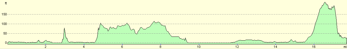
For more information on profiles, ascents and descents, see this page
Accommodation
We stayed at the caravan park at Ballaport Farm, Tal-y-bont, Barmouth, Gwynedd LL43 2BX. This site was in a beautiful situation, with some lovely views available out to see and northwards towards the Lleyn Peninsular. The site cost us eleven pounds for the night, and was well worth the cost. They can be contacted on (01341) 247338.
Disclaimer
Please note that I take no responsibility for anything that may happen when following these directions. If you intend to follow this route, then please use the relevant maps and check the route out before you go out. As always when walking, use common sense and you should be fine.
If you find any information on any of these routes that is inaccurate, or you wish to add anything, then please email me.
All images on this site are © of the author. Any reproduction, retransmissions, or republication of all or part of any document found on this site is expressly prohibited, unless the author has explicitly granted its prior written consent to so reproduce, retransmit, or republish the material. All other rights reserved.
Although this site includes links providing convenient direct access to other Internet sites, I do not endorse, approve, certify or make warranties or representations as to the accuracy of the information on these sites.
And finally, enjoy your walking!
This walk was mentioned in the following routes:
| My walk around the coastline of Britain |
Nearby walks
| # | Title | Walk length (miles) |
|---|---|---|
| 397 | Cwrt to Fairbourne | 22.3 |
| 399 | Harlech to Porthmadog | 15.2 |
|
|

|