Walk #642: A circular walk around Royston
 |
 |
|
General Data
| Date Walked | 09/01/2005 |
| County | Cambridgeshire, Hertfordshire |
| Start Location | Therfield Heath |
| End Location | Therfield Heath |
| Start time | 09.40 |
| End time | 15.00 |
| Distance | 17.2 miles |
| Description | This was an enjoyable little stroll, taking in a few hills around the town. |
| Pack | Today I carried my 30-litre Karrimor HotRock rucksack, which was filled with three litres of water, a spare fleece, waterproofs and various electronic gadgets. |
| Condition | I feel absolutely fine after this walk, and could have walked further if I had needed to. I have slight hotspots on the underside of my feet as I wore only one layer of socks. |
| Weather | The weather started off quite well today, although as the day went on the clouds gathered and I walked for the last half-hour in light drizzle. It was not a cold day, but there was a bitter wind that made me quite cold when I was exposed to it. |
| OS map | Landranger number 154 (Cambridge & Newmarket, Saffron Walden) and Landranger number 153 (Bedford & Huntingdon, St Neots & Biggleswade) |
 |
 |
|
 |
 |
|
Map of the walk
Maps courtesy of Google Maps. Route for indicative purposes only, and may have been plotted after the walk. Please let me have comments on what you think of this new format. For a detailed table of timings for this walk, please see the table file.
 |
Notes
After heavy winds yesterday that caused chaos through the north of England and Scotland, the day dawned bright, albeit still distinctly breezy. The weather forecast was for a dry day, and so I decided to go for a walk. I could not be bothered driving too far for the day, and so I sat down with my maps and decided on doing a circular walk based on Royston, which is situated fairly near to my home. As the walk was so near home it allowed me to have a later start - one of the things that annoys me about walking in winter is the early starts required due to the lack of daylight hours.
There was a car park marked on my maps to the west of Royston on the edge of Therfield Common, and the A505 took me right to it. The small car park was nearly full, and for a few moments I was worried that the car park was private for the use of the golfers from the adjoining course. A quick look around showed this not to be the case, so I shouldered my rucksack and headed down, passing a Little Chef before reaching the A505. It was not clear from my 1:50,000 map the route that the footpath took to cross the railway line that runs alongside the road, but when I got there I found a good track leading down to the railway line, and a little gated pedestrian crossing at the end of the track.
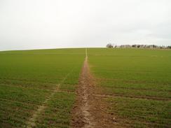
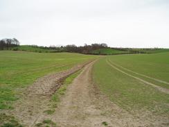
As I followed the path northwards across the field I was exposed to the wind and I got fairly chilly, although by the time I had reached another footpath I had warmed up somewhat. The path across the fields had been cleared by the farmer, making route-finding simplicity itself. The views from the top of Limlow Hill - in any other counties it would merely be a bump in the landscape, but in this area it is a hill - were nice, and I could make out my car clearly in the car park to the south. On the hill there is a trig pillar, and when I had walked this way a few years before I had not managed to find it. This time I found it fairly easily and it was obvious why I had not found it before - the pillar is embedded in a hedge, and in summer it would be fairly well obscured by vegetation.
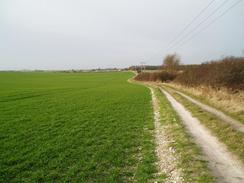
The path led down to meet the Icknield Way immediately to the south of the village of Icklington. The Way in this location is a broad, green track, although annoyingly some overhead cables run to one side and spoil the otherwise pleasing symmetry of the lane. I made good progress as I headed along the lane, and listened to the radio as I plodded along. Just before I reached the A1198 road there was a farm on the left, and I was amused to see a barn that had just been moved by the farmer, having been pulled along by a large truck tow vehicle. This seemed a very economical way of moving the barn, although I wondered how the stress had affected the structure.
The lane became less interesting as I walked along, and I was quite relieved when I approached the A10 to the west of Melbourn as it marked the point where I would be leaving the lane. First, I had to cross a railway line and just before I reached the bridge under the line there was a forlorn burnt-out car, which really made me feel as though I had left the countryside and entered a more urban environment. As I walked through the western outskirts of Melbourn I was surprised to see a fox run across the road a few yards in front of me; halfway across the road it stopped to look at me for a couple of seconds before running on and disappearing to my left. The sight startled me, and I found myself looking to my left to see if I could see any trace of it in the scrub, and unfortunately failed.
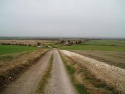
The map shows a footpath following a track called London Way southeastwards towards Muncey's Farm, where it ends. I wanted to continue on along the track towards the A505, but as the footpath ended at the farm I had little idea whether I would be able to. Immediately by the farm there was a sign stating 'private', but seeing no one about I walked on. A little further on there was a little area filled with scrap cars, and as there was a man there I decided best to pre-empt comments and ask for permission to continue on. This he freely gave, and I continued on up the hill.
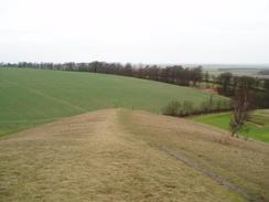
Once at the top of the hill I left the track and followed a hedge southwestwards, heading above Heath Farm before hitting a track. I was aiming for the trig pillar at the top of the hill, and on the way there I got some expansive views in most directions. It was worth pausing to admire the view, but the hill was quite exposed and the wind was making me feel more than a little chilly. I therefore headed the few yards off the hill to the trig pillar, which turned out to be situated in another hedge. I photographed it before heading back to the track and facing a decision; in the end I decide to cut cross-country down to the A505, and I followed field boundaries all the way down to the road.
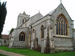
The A505 proved slightly difficult to cross due to heavy traffic, but once on the other side I could start following another branch of the Icknield Way. I had walked along this path a few years previously, and although the road was only a few yards away it made for a reasonably pleasant walk before it ended and I was rudely and abruptly dumped on a road. Right by this junction there is a marker for the Greenwich meridian, and I just about managed to resist the temptation to set my GPS to longitude and latitude to precisely check its position. The next stretch of road walking into the centre of Royston was the most boring stretch of the day's walk, and I was glad when I reached the attractive St. John the Baptist parish church, which is the only remaining part of an Augustinian Priory set up before 1180. The church is surrounded by some attractive formal gardens that made for a far more pleasant walk than the alternative route along the road.
The battery on my Walkman gave up the ghost a few minutes later, and as there was a bench nearby I took my rucksack off so that I could change the battery. I was glad as I did this, as I also took the opportunity to look at a rough stone beside the bench. This turned out to be Roisia's Stone, which had been the base of a long destroyed cross that had stood nearby. The cross marked the crossing point of two Roman Roads, Ermine Street (which runs between London and York) and the Icknield Way (from Salisbury Plain to East Anglia). The town that formed around the crossroads became known as Roisia's Town, and, eventually Royston.
I followed the road westwards out of the town until I reached a car park next to a golf clubhouse; this was only about a kilometre away from where I had parked my car, and although it was tempting to finish the walk early I decided to continue on. The route I took headed in a rough southerly direction along the edge of Therfield Heath, and I enjoyed the nice views as I walked. The path joined a track, and this proved easy to follow as it headed into the village of Therfield. I resisted the temptation of nipping into the village pub for a quick pint, and instead walked on towards the attractive village church. A little further on I nearly reached my next target, a trig pillar beside a large, white, water tower that dominates the local landscape. I only nearly reached it as the pillar stood within the compound that surrounded the water tower, and high fences guarded this. By walking around the compound I could get near enough to touch it through the fence, but there was absolutely no way I was able to record its flush bracket number.
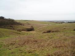
A good path went northwestwards out of Therfield, and I enjoyed the stroll, taking in the scenery as it descended downhill, passing a small shooting range dug into the hillside on the way. By the time that I reached the farm at The Thrift (home in times past to fiscally aware people?) it had started to spit with rain, and as I joined what is marked on some maps as a path eastwards beside the Kings Ride it started to get slightly heavier. I was loathed to put my coat on this near the end of the walk, so I let my fleece soak up the light rain and continued onwards. At the end of the Kings Ride I continued on, and joined a path for a short but steep climb up onto the Pen Hills. The views from here were nice, and if it had not been for the rain I may have stopped to admire the views for longer. Instead I plodded on, and soon entered an area of woodland that protected me from the worst of the rain. The path through the woodland was easy to follow and I enjoyed this stretch of the walk, until the woodland and path abruptly ended at a road. The car park and the end of the walk was a short distance downhill along this road, and I watched golfers tee off on the greens beside the road as I headed downhill, happy at having finished a surprisingly enjoyable day's walk.
Directions
This walk starts off at a car park near to a roundabout off the A505 to the west of Royston, at about TL336403. Leave the car park and head north for a couple of hundred yards downhill along the road, until it ends at a T-junction with another road. Turn left along this road and follow it west for a hundred yards, passing a Little Chef before reaching a large roundabout. Turn right to head north across the A505, and once on the other side join a concrete track that skirts the A505 for a few yards before turning to head north, before ending at a pedestrian crossing over a railway line.
Cross the railway line and follow a bridleway northwards, with a hedge on the right. Shortly before a narrow band of woodland is reached a footpath angles off to the left, shortly reaching the woodland and passes through it before heading in a more northwesterly course, climbing up to skirt the flat summit of Limlow Hill. Once at the top it starts to descend towards some buildings; it skirts the eastern end of these before continuing on across a field and reaching a green lane immediately to the south of the village of Litlington.
Turn right and follow the green lane as it heads slightly north of east for a few miles; it crosses the A1198 and about a mile later it passes under a railway line and reaches the A10. Cross this road, and once on the other side take a road that leads off the A10, heading northeastwards into the village of Melbourn. Follow the road into the village and when it starts to curve to the left, turn right up Back Lane. Almost as soon as you do this, turn right and start following a track called London Way uphill. This soon curves to the left, and starts heading southwards towards Muncey's Farm. Please note that at Muncey's Farm the public right of way along the track ends, and therefore if you do not like trespassing you will have to find a route further to the east from Melbourn.
Follow the track past Muncey's Farm, where the right of way ends. The track climbs uphill, and at the crest of the hill I turned right to visit a trig pillar. If you do not want to do this, then continue on until the track ends at the A505 road. Once at the road turn right and start following it southwestwards for about half a mile; this has to be done with care as the road is quite busy. As the road approaches the eastern edge of Royston it approaches the Icknield Way on the left; find a gap in the hedge and join the Icknield Way, which provides an easy traffic-free route westwards. The Way abruptly ends at a metalled road; turn right down this road for a few yards until it ends at a T-junction with Newmarket Road opposite a Greenwich Meridian marker.
Turn left and start following Newmarket Road westwards towards the centre of the town. In the centre the road crosses the A10 to become Melbourn Street and then, after a short distance, Baldock Street. Continue along the road for a couple of hundred yards until a car park next to a golf clubhouse is reached; turn to the left and start heading south, passing the golf clubhouse before heading on uphill, initially with a hedge to the left. When a track diverts away to the left continue on along a rough path, heading slightly west of south along the very edge of Therfield Heath. The path descends along the edge of a little valley before climbing out again.
The path soon joins a track, and this continues on, slowly heading uphill in a rough southwesterly direction, following a branch of the Icknield Way path. When the track approaches the top of the hill and starts to curve to the right, continue straight on along a footpath that heads across a field before reaching a road beside the pub in the village of Therfield. Cross the small road and then the village green, before heading southwest for about a hundred yards down Church Lane. Enter the churchyard, and angle slightly to the left from the main porch to leave the churchyard via a gate.
Follow the path along the boundary of the churchyard, and when the latter curves to the right follow it as it heads northwards, heading towards a water tower. The path passes to the right of the compound housing the water tower, and continues on until a road is reached. Turn right along this road for about fifty yards until a footpath leads off to the left. Follow this footpath as it heads downhill, initially along a sunken track before entering a field. The path is easy to follow as it heads southwestwards, following the Chain Walk. The path passes a little quarried-out section of the hillside to the left - the sight of a shooting range - before heading on to meet the end of a track.
Join the track and follow it as it heads southwestwards, passing through the farm at The Thrift. Once past the buildings turn right along another track that starts to head uphill in a northwesterly direction. When the track approaches a stables, turn left and then right, leaving the track and walking on with a hedge on the right and a ride on the left. The path skirts some trees on the right, before ending at a track at the edge of a golf course. Turn right and then left, to head along a track for a few yards, before turning to the left to join another footpath.
This footpath heads up a steep but low hill, before following the crest of the hill and entering an area of woodland. The path is easy to follow as it heads eastwards through the trees, before it abruptly ends at a road. Once there, turn left and follow the road as it descends downhill to the north; the car park where this walk began is on the left just before the road ends at a T-junction.
Distances
| From | To | Distance (m) | Ascent (ft) | Descent (ft) |
|---|---|---|---|---|
| Therfield Heath | Melbourn | 6.2 | 115 | 291 |
| Melbourn | Therfield | 7.1 | 797 | 370 |
| Therfield | Therfield Heath | 3.9 | 289 | 540 |
This makes a total distance of 17.2 miles, with 1201 feet of ascent and 1201 feet of descent.
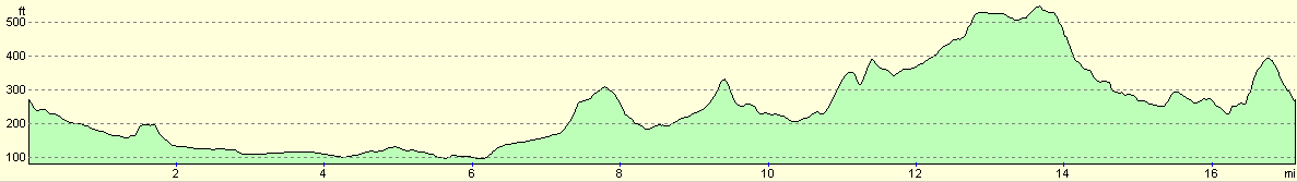
For more information on profiles, ascents and descents, see this page
Disclaimer
Please note that I take no responsibility for anything that may happen when following these directions. If you intend to follow this route, then please use the relevant maps and check the route out before you go out. As always when walking, use common sense and you should be fine.
If you find any information on any of these routes that is inaccurate, or you wish to add anything, then please email me.
All images on this site are © of the author. Any reproduction, retransmissions, or republication of all or part of any document found on this site is expressly prohibited, unless the author has explicitly granted its prior written consent to so reproduce, retransmit, or republish the material. All other rights reserved.
Although this site includes links providing convenient direct access to other Internet sites, I do not endorse, approve, certify or make warranties or representations as to the accuracy of the information on these sites.
And finally, enjoy your walking!
Nearby walks
| # | Title | Walk length (miles) |
|---|---|---|
| 10 | Waterbeach to Great Chesterford via Cambridge | 21.0 |
| 96 | Great Chesterford to Royston | 16.6 |
| 121 | Royston to Hitchin | 17.3 |
|
|

|