Walk #643: A circular walk from Thrapston to Oundle
 |
 |
|
General Data
| Date Walked | 15/01/2005 |
| County | Northamptonshire |
| Start Location | Thrapston |
| End Location | Thrapston |
| Start time | 09.11 |
| End time | 15.53 |
| Distance | 19.4 miles |
| Description | I enjoyed this circular walk much more than I was expecting, which was mostly due to the picturesque villages that my route passed through. |
| Pack | Today I carried my 30-litre Karrimor HotRock rucksack, which was filled with three litres of water, a spare fleece, waterproofs and various electronic gadgets. |
| Condition | I feel absolutely fine after this walk, and could easily have walked further after a little rest. The only slight problem was a slight pain in the arch of my left foot that manifested itself on the drive back. |
| Weather | The day was overcast and I cannot recall having seen even a glimpse of the sun; however it was dry, except for a five-minute shower towards the end of the day. It was not a cold day, and I was overheating slightly in my fleece. All in all it could have been a much worse day for walking. |
| OS map | Landranger number 141 (Kettering, Corby & surrounding area) and Landranger number 142 (Peterborough, Market Deeping & Chatteris) |
 |
 |
|
 |
 |
|
Map of the walk
Maps courtesy of Google Maps. Route for indicative purposes only, and may have been plotted after the walk. Please let me have comments on what you think of this new format. For a detailed table of timings for this walk, please see the table file.
Notes
For some time I had been looking at filling in a gap in the walks that I have done, the gap being mainly in northern Northamptonshire. An obvious route that I had been planning was to walk from Kettering to Corby and then onto Oakham, but this is, frankly, a not particularly scenic route and so I started looking for alternatives. I soon settled on doing a few circular walks based on more scenic areas, and I decided to do the first of these today. I therefore found myself making the relatively short journey up the A14 from Cambridge and drive to Thrapston, a village that I have driven past along the A14 countless times but never actually visited.
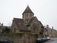
It was quite nice to find a free car park in the centre of the village, and as I had made better time than I had expected on the drive I took my time getting all my kit together. I then locked up the car and headed off, pausing at a shop opposite the car park to get a couple of chocolate bars for the journey. I have always admired the villages in this little part of Northamptonshire, as the buildings are made of a light-coloured stone that reminds me to a certain extent of the glories of Cotswold buildings. The churches in particular are nice, with unusual stone-built spires that have little windows in them. Thrapston is no exception to this, and I walked around the church studying it before walking along the main road through the village. The Corn Exchange in particular was worthy of note, with some elegant carving above the doorways.
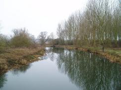
Flood prevention work was being done near to the Bridge over the River Nene between Thrapston and Islip, and the river did not look particularly attractive at this location. I therefore passed The Woolpack pub and headed along roads northwards, passing Islip Church, which was yet another good example of the local church style. In Islip I joined the Nene Way, which I would follow in various directions for much of the day. In a field immediately outside the village there were two swans standing on the grass near a pond. They seemed very tame, and allowed me to get quite close to them, and I used the opportunity to shoot off a few pictures. Not long after this the Nene Way entered the Titchmarsh local nature reserve, and on a notice board I was surprised to find that the reserve had a Heronry that was still in use.
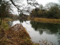
The area covered by the lakes is quite extensive, and it took me a little time to pass them all. There were a series of boats on the lake to my left, each containing two fishermen who were obviously enjoying their day out. Virtually as soon as the lakes ended the path entered the small village of Aldwincle, which must be unusual for a village of its size in having two churches. One of these is no longer in use, but again I admired the architecture of the one that was still in use. A footpath led northwards out of the village, skirting the western bank of the River Nene before entering a wooded area; the path ascended, descended, and was muddy and slippy in places. This meant that I could not keep up a fast pace, and I soon found myself passing under Wadenhoe Church, which is built on a little hill overlooking the river, and entered the village.
I fell in love with Wadenhoe on first sight. It is a superb little villager, with nice, neat houses flanking the High Street. The buildings in the main section of the village are without exception pretty, and even where a new one had recently been built it fit in with the overall style. I wandered through the village admiring the architecture, and then started walking along the road out of the village. In once place a footpath gave a short-cut across a field, but the footpath was indiscernible on the ground and I decided to take the road route instead, which was hardly much longer. My next target was the trig pillar situated to the north of the village; the OS call this pillar by the strange but undoubtedly interesting name 'Top Trespass'; I can only wonder how it got such a name. The pillar proved to be quite easy to find in the corner of the field, and for once was actually set away from the hedge instead of being embedded within it.
A short footpath took me to a road, and I would follow roads for the rest of the way northwards into Oundle. On the way I passed through the little village of Stoke Doyle, which again had some picturesque houses in it. Soon after this I found myself entering Oundle, a small town that is dominated by the school of the same name. Many of the buildings in the town are related to the school, and as I walked along I tried to guess which ones were privately owned. As if to reinforce the scholarly background to the town there were children in uniforms everywhere, a reminder that students at private schools study on Saturdays, just as I had at my school. The town was fairly bustling with children, locals and tourists, and I decided to hide for a while in a pub. I had been making good time and looking at the distance that I had to go I decided to nip into the Rose and Crown for a quick pint.
I had done a reasonable job of scraping all the mud off my boots, but I still sat down in a corner nearest the door to avoid any damage to the carpet. The pint of Resolution (4.7% volume) slipped down easily, but as I still had ten miles to walk I could not afford to take much extra time, and so I found myself shouldering my rucksack and heading off down the road. Roads and a path led down to a bridge over a stream and then onto a lock on the River Nene; on the way I passed a weed-filled area that looked remarkably like an old outdoor swimming pool. The lock was of the flood prevention type; the lower set of gates being traditional lock gates, and the upper one being a drop-gate that drops down to block the water flow. The path soon became a track that ended by a road at Oundle Marina. The road headed for a couple of kilometres to the A605, which I crossed before entering the village of Barnwell.
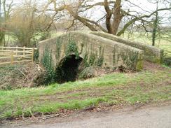
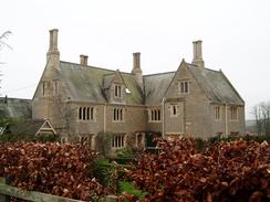
There is a castle marked on the map in Barnwell, and as I knew nothing about it I was intrigued to see what remained of it. Many castles marked in such a way comprise of a few stones and the Motte; indeed Cambridge Castle is an example of where the only sign of it is a rapidly eroding hillock. However as I approached the castle I was surprised to see some fairly substantial walls standing, but I was annoyed to find that there were gates guarding the whole site (which includes a Manor House that until recently was the home to the Duke and Duchess of Gloucester) from the public. The castle was built during the reign of Henry the Third, and the walls apparently still rise to a height of thirty feet. I was quite annoyed at not being able to get a closer look at the ruins, perhaps reasonably, perhaps unreasonably, but these feeling were at least partially assuaged by finding a delightful narrow arched bridge over a stream nearby.
This I could walk over, and I followed it down to the village church and on down through the village. Heading south the village has a stream running through it, with houses on either side, and a couple of footbridges and a ford to help get between the roads on each bank. On the way I was surprised to find a delightful set of Almshouses just off the road; these are still in use for their original purpose, and there was a notice outside stating that a vacancy was available. I found this to be a wonderful find, and although Almshouses go somewhat against the modern welfare state principles, it can hardly be a bad thing. At the end of the village there is a graveyard that surrounds an old church building; I have not been able to find any details of this building, although I suppose that it may have had something to do with the Priory that once stood in the village.
The path crossed an old railway line and then followed field boundaries down to the hamlet of Wigsthorpe. A short stretch of road led down to the B662, and from there I took a bridleway down past Thorpe Fox Covert. I could hear the sound of shooting going on and figures in the field, and I was relieved when a whistle blew as I approached and the guns fell silent. In the middle of the field beside the bridleway there was a strange device consisting of a pole, on which there were two four-bladed sails, rotating in the wind. As the blades were shiny it made for a slightly mesmerising sight, and I wondered what it was for. The shooters were obviously giving up for the day, and as I walked along a track past the woodland I met one of them. He had his shotgun with him and was holding three grouse; I chatted to him for a few minutes about shooting; initially he was wary of me but he soon opened up and became chattier.
The bridleway continued on into the village of Titchmarsh, which I did not see much of as I headed straight out of the village before taking a fairly nondescript footpath that headed westwards back towards Thrapston. This crosses a minor road before reaching the A605 road. Here I chose to extend the walk slightly, and instead of heading directly back into the village I walked down a track until I met the course of an old railway line beside one of the lakes of the Titchmarsh local nature reserve. A path ran southwestwards along the trackbed, and as I walked along it the light began to fade, marking the onset of night. I did nit have far to go, however, and once I reached a track that cut across the trackbed I followed it back into Thrapston and soon reached the car park and my car. The last stretch was slightly off-putting, as there were lots of hooded youths about, a scene that I found to be slightly (and probably unreasonably) sinister in the dusk light. I enjoyed this walk much more than I had been expecting, which was mainly due to the lovely villages that I passed on the way.
Directions
This walk starts off at the public car park in the centre of Thrapston, which is situated just off Sackville Street. Leave the car park and turn left to head along Sackville Street for a few yards towards the church until it ends at a T-junction with Oundle Road. Turn left and follow Oundle Road southwards for a few yards until it too ends at a T-junction with High Street, and then turn right to start walking westward. The road leaves the town and crosses a bridge over the River Nene to enter the village of Islip, and when The Woolpack pub is reached on the right. Here the route joins the Nene Way, which will be followed for the next few miles. Turn right up Chapel Hill Road, and when it soon ends at the High Street in Islip turn right and follow this road northwards past the church. When Lowick Road leads off to the left turn off the road to the right, following the Nene Way as it squeezes between houses and crosses a field.
When the path nears the river it crosses Mill Lane and continues on northwards past a ruined barn. The path soon arrives at a band of trees; once in the trees the path is easy to follow, as it turns right, shortly emerging from the woodland by a lake. Turn left, and follow the Nene Way as it enters the Titchmarsh Local Nature Reserve. From here it heads northeastwards, passing along a narrow band of land between two lakes. Once the lakes end it follows the right-hand bank of a stream onwards until it reaches a bridge over the stream. Cross the bridge, and walk up a short green lane towards a car park and a road to the south of Aldwincle. Turn right and follow the road northwards; at the second right-hand bend a footpath with a tarmac surface heads off to the north. Follow his track as it heads uphill for a short distance before it ends at a road. Turn left along this road and follow it northwestwards past Aldwincle Church; when a road junction comes in from the left follow the Nene Way as it turns right and squeezes between fences and entering a field.
The path heads northwards, nearing the River Nene before climbing up to enter some scrub woodland, which it rises and descends through before passing under Wadenhoe Church and meeting the end of a road in the village. Here the Nene Way is left for the moment; turn left and follow the road uphill past the pub, and when the road ends turn left to head northwestwards through the village. At a junction near a memorial take the right-hand road, which heads northwestwards for a couple of hundred yards until it ends at a T-junction with another road. Turn right along this road and walk past a short stretch of woodland on the left. Immediately after the woodland to join a footpath that starts heading northwards across a field, aiming for a patch of trees on the skyline to the north; just before the trees are reached there is a trig pillar in the corner of the field to the left. Once at the trees turn right and follow their southern edge northeastwards until it meets a road.
Turn right along this road and follow it southeastwards for about half a mile until a crossroads is reached. Here turn left, and start following another road northwards for three miles; it passes through Stoke Doyle on the way before finally reaching Oundle. The road joins the A427 near an unusually shaped church and heads eastwards through the town. When the A427 turns sharply to the left to head north, turn right down St Osyth's Lane; this heads downhill and when it curves to the right turn left down Bassett Ford Road. When this ends at a field after a short distance head straight on along a footpath; here we have rejoined the Nene Way, although it is being followed in the opposite direction to earlier in the day. This soon crosses a long, narrow bridge over a tributary to the River Nene before reaching the river itself by a lock. Cross the river using the bridge, and once on the other side turn right and start following the eastern bank of the river downstream. The path soon becomes a track, and this ends at a road near to Oundle Marina.
Follow the road southwards for a couple of kilometres; shortly before it joins the A605 turn left along a footpath that heads eastwards for about fifty yards before reaching the A605. Cross the A605, and once on the other side continue on along a footpath that soon ends at a road. Turn right and follow this road as it quickly heads into the village of Barnwell, skirting around the grounds of the castle. When a little arched footbridge over a stream is reached on the right cross this and follow a footpath south into the churchyard. Walk through the churchyard and then leave it by a gate onto a road. Turn left along this road for a few yards and then turn right by a bridge over a stream; this road heads south with the stream on the left. When a graveyard is reached on the right and enter it; walk past the old church building and leave by a gate. A footpath then heads across a field, crossing the trackbed of the old Thrapston to Oundle railway line and continuing on a slight west of southerly route until it meets a road in Wigsthorpe.
Head south along the road and when it ends at a T-junction with the B662 turn left to cross a bridge over the old railway trackbed. A few yards further on turn right to join an easy to follow bridleway that heads slightly west of south, aiming for the eastern tip of Thorpe Fox Covert. When the woodland is reached turn right along a track that skirts the southern edge of the woodland, and when the end of the trees is reached after a short distance turn left to continue along the bridleway. This reaches a little bridge over a stream; once on the other side turn left to start following the southern bank of the stream. The stream starts to curve around to the right, and when it splits start following branch southwestwards. The bridleway eventually meets a track, which can be followed onwards until it swings around to the right just outside the village of Titchmarsh. A few yards after the bend take a footpath off to the left, which heads across a small field and between houses before ending at a road in the village.
Cross the road near the village pub and start heading south along another road; after a hundred yards take a footpath that leads off to the right. This immediately climbs uphill, before crossing fields westwards. Follow the footpath for a couple of kilometres; after a mile it crosses a road before eventually reaching the A605 road. Cross the A6-5, and since on the other side head straight on along a short, unsurfaced lane. When this ends turn left and follows a footpath that runs along the old railway trackbed southwestwards for a mile. When this in turn ends, turn left and follow an unsurfaced track eastwards. This soon ends at Chancery Green Lane; cross this and head DeVere Road, which soon ends at Oundle Road. Turn right along this road for a few yards and the car park where this walk started and ends is on the left.
Distances
| From | To | Distance (m) | Ascent (ft) | Descent (ft) |
|---|---|---|---|---|
| Thrapston | Oundle | 9.3 | 381 | 404 |
| Oundle | Thrapston | 10.1 | 427 | 404 |
This makes a total distance of 19.4 miles, with 808 feet of ascent and 808 feet of descent.
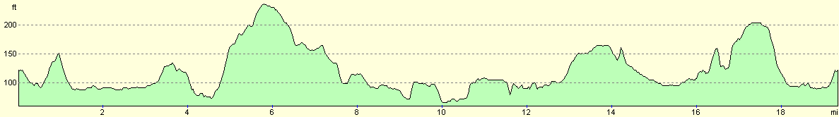
For more information on profiles, ascents and descents, see this page
Disclaimer
Please note that I take no responsibility for anything that may happen when following these directions. If you intend to follow this route, then please use the relevant maps and check the route out before you go out. As always when walking, use common sense and you should be fine.
If you find any information on any of these routes that is inaccurate, or you wish to add anything, then please email me.
All images on this site are © of the author. Any reproduction, retransmissions, or republication of all or part of any document found on this site is expressly prohibited, unless the author has explicitly granted its prior written consent to so reproduce, retransmit, or republish the material. All other rights reserved.
Although this site includes links providing convenient direct access to other Internet sites, I do not endorse, approve, certify or make warranties or representations as to the accuracy of the information on these sites.
And finally, enjoy your walking!
Nearby walks
| # | Title | Walk length (miles) |
|---|---|---|
| 142 | Huntingdon Station to Hargrave | 17.3 |
| 184 | A circular walk between Hargrave, Raunds and Rushden | 18.4 |
| 647 | A circular walk from Oundle to King's Cliffe | 19.6 |
|
|

|