Walk #644: A walk between Clare and Long Melford
 |
 |
|
General Data
| Date Walked | 21/01/2005 |
| County | Suffolk, Essex |
| Start Location | Clare |
| End Location | Clare |
| Start time | 08.48 |
| End time | 15.25 |
| Distance | 19.6 miles |
| Description | This was a nice circular walk around the Stour valley, taking in some picturesque villages on the way. |
| Pack | Today I carried my 30-litre Karrimor HotRock rucksack, which was filled with three litres of water, a spare fleece, waterproofs and various electronic gadgets. |
| Condition | I feel absolutely fine after this walk, and have no significant problems too report. I could easily have walked further if I had needed to. |
| Weather | The day was mostly sunny with some periods of thin cloud; there was no sign of any rain. There was a cold wind blowing, which effectively counteracted the heat from the sun and made me cold. |
| OS map | Landranger number 155 (Bury St Edmunds, Sudbury & Stowmarket) |
 |
 |
|
 |
 |
|
Map of the walk
Maps courtesy of Google Maps. Route for indicative purposes only, and may have been plotted after the walk. Please let me have comments on what you think of this new format. For a detailed table of timings for this walk, please see the table file.
 |
 |
|
Notes
It had been my intention to drive up to North Yorkshire today for a little four-day walking holiday, but unfortunately I have been ill this week and really could not face the long drive. For this reason when I woke up feeling a little better this morning I was slightly unsure what to do. I did not fancy doing any of the local walks that I had planned but neither did I want to travel too far, and so in the end ten minutes work on Anquet had this local walk on the Suffolk / Essex border planned.
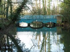
The journey to that start of the walk at Clare was pleasant enough, and when I got there I was pleased to find a convenient car park that only cost one pound for the day. I did not leave immediately and instead prevaricated for a while, taking my time in getting my kit together. The first part of the walk took me across an old railway bridge over the River Stour and past the site of Clare Priory; I was surprised to find that this had been re-established on the site of the old Priory, which had been dissolved during the Dissolution of the Monasteries. I was tempted to go into the grounds for a quick look around, but I decided against it and followed the old railway trackbed the short distance to a very attractive bridge over the river.
A little road walking took me to the start of a public byway, and on the way I managed to catch sight of the dominant remnants of Clare Castle, which I had failed to see despite parking only about twenty yards away from them. The byway, which was shaded by hedges on either side, made for a pleasant enough walk, and I soon diverted off it into an adjoining field to find a trig pillar. This proved to be buried inside a hedge, and if the hedge had been growing would have been very difficult to find. I recorded its number and then walked back to the track,
This led on to another road, and I followed this for only a short distance before joining another footpath that took me eastwards along field boundaries into the village of Belchamp St Paul, which I found to be an intriguing name for a village. The village pub was situated in a nice thatched building, and I found myself wishing that it was open so I could go in for a drink. More road walking led me to another footpath that arched around before depositing me on another road near Hobart's Hall. By this time I was thoroughly enjoying the day's outing, and I was keen to press on to see more of this lovely part of the country.
Shortly after this I joined a bridleway that took me through some woods; in the woods I heard several gunshots close by, and their closeness unnecessarily disturbed me. I got out with my life, if not my sanity, intact, and another bridleway took me along a track to a road. The rest of the way into the attractive little village of Foxearth was along roads, and this proved to be the most boring and uninteresting stretch of the day. In the village I resisted the temptation to visit the church, and instead walked on along the B1064 out of the village. I soon left this road, and joined a footpath that headed along a track, skirting near to a hall before rudely depositing me on another road by the church at Liston, which seemed to only serve the couple of houses adjoining it; I wonder where the parishioners come from?
The rest of the walk into the town of Long Melford was along a road, which crosses the River Stour before joining the main road through the town. Here I also joined the Stour Valley Path, which I would be following for the vast majority of the rest of the day. I walked along this revelling in the architecture - many of the buildings were painted in different hues, a Suffolk trademark, and it all made for a very attractive sight. I had made good time this far through the day, and so I decided that I could afford to take a little time off. I passed the Crown Hotel and, seeing that it was open, decided to nip in for a quick pint. I chose a pint of IPA, and used this to wash down some crisps whilst trying not to get any of the mud from my boots onto the nice carpet. The hotel was quite nice and I started to feel self-conscious about my muddy clothes and boots, so I quickly drunk up and headed on down the road.
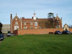
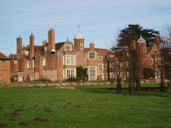
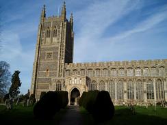
On leaving the village I almost immediately passed Melford Hall, a grand pile that appeared to be brick-built. Although there were some interesting architectural details I was not too impressed by this, and so I only took a couple of photographs before heading towards Long Melford Church. This turned out to be a magnificent building, and the cholestory was lined with graceful, soaring windows. It made all the other churches that I saw today pale into insignificance, and I wandered around the outside literally revelling in its glory. I had not realised that in visiting the church I had left the footpath, and after walking around the northern end of the churchyard I discovered to my annoyance that the footpath ran along the track to the east. As usual in such circumstances I was loathed to turn back, and so instead I found a place where the barbed wire fence was down and jumped off the retaining wall of the graveyard into the surrounding ditch. I was in a hurry to get out of the mud in the ditch, and in doing so did not see the barbed wire of the fence, which promptly tripped me up and left me lying on the ditch bank, with my hands covered in mud and my lower left leg cut by the wire.
Trying not to curse so near to consecrated ground I picked myself up and headed off across the field to rejoin the footpath, which ran alongside a track leading towards Kentwell Hall. From the outside this seemed to me to be a much more impressive building than Melford Hall, and I could not resist taking a few photographs before heading off along the footpath. The Stour Valley Way soon branched off onto another footpath, which started the long plod westwards back towards Clare. Initially the muddy footpath led beside some woodland, before descending down to a road and then on to a rather rickety bridge over the River Glem. A rather unremarkable path took me on to the village of Glemsford, which I did not see much of as I soon joined another forgettable stretch of footpath that led me on to the village of Cavendish.
I found Cavendish to be much more my cup of tea, and I enjoyed my walk through the village. Many of the houses along the way were attractive, and the church appealed to me, particularly because of the unusual suspended bell arrangement on top of the tower. I found it slightly difficult to find the path leading away from the church, but once on it I sped on towards Houghton Hall and then Hermitage Farm, Here I left the Stour Valley Way for the last mile into Clare; in the bar in Long Melford I had seen a picture of Clare Church, which is situated in an island between two roads, and I was keen to see it, As the Way bypassed the church I had little alternative but to walk along the road, although this was no real hardship as there were some more lovely houses to look at.
The church was pretty enough, but also a slight disappointment as I could not get a good position through the trees to take a photograph. However I did not walk around it, so it could be that I missed one on the eastern side. I was surprised to see an antiquarian bookshop in the village, and, annoyed at being muddy and therefore not being able to go in, I walked back to the car and ended the walk, That was, however, not quite the end of the day. The sight of the castle walls early on in the walk intrigued me, so without even unlocking the car I walked on into the country park and soon found the steep-sided motte. A spiralling path led up this, and I soon found myself standing at the top beside the tall but fragmentary remains of the old castle. The views from the top were most satisfying, and this turned out to be a very nice way of ending the days walk.
Directions
This walk starts off at the car park beside the Clare Castle Country Park. Leave the car park and use the old railway bridge in the southwestern corner to cross the River Stour. Follow the path on southwestwards, passing the priory grounds before reaching a road by a bridge over the river. Turn left to join the road as it heads southwards, and when a road junction is reached turn left and follow this new road eastwards. After a few hundred yards a by-way is reached on the right; turn right and start following this byway southwards for a couple of kilometres.
The byway ends at a road T-junction. Head straight on southwards down the road for a couple of hundred yards, before turning to the left to join a footpath that heads eastwards across fields for about a mile before ending at a road in the small village of Belchamp St Paul. Turn left and follow the road northeastwards through the centre of the village, passing the pub on the right and then, on the northern outskirts of the village, turning right along another road. After a short distance this turns sharply to the left and then the right before heading southeastwards; about a hundred yards after the last bend turn left along a footpath.
The footpath curves eastwards for a little over a kilometre before ending at a road near Hobart's Hall. Turn left and follow this road eastwards past Bevingdon House; when the road curves to the right turn left to follow a bridleway that heads northeastwards. When the bridleway enters a patch of woodland it turns to the left, to head northwards across a stream and ending at a T-junction with a green lane, Turn right and follow this lane eastwards for about half a mile until it ends at a road. Turn left along this road and follow it as it heads northwards for a couple of miles, passing Temple End before reaching the B1064 road in Foxearth. Join the B1064 and follow it as it heads eastwards, passing south of the church (which is nearly out of view behind buildings) and leave the village.
The B1064 passes a road junction on the left; a couple of hundred yards after this turn left to follow a bridleway that runs along a track. This heads northeastwards towards a hall; just before it reaches the hall another track is met. Turn right and follow this track eastwards as it heads downhill until it ends at a road by the church in Liston. Join the road, and follow it as it heads northeastwards, crossing the River Stour before entering Long Melford. When the road ends at the B1064 in the town turn left and start following it northwards out of the town. When Melford Hall is reached leave the road and follow a track that heads due north towards Long Melford Church.
Just before the church is reached theA1092 is met; turn right along this road and follow it as it curves to the northeast; when a track leads off to the left join it and follow it as it heads northwestwards towards Kentwell Hall. When the gates of the hall are reached turn left and follow another track that skirts around to the western side of the hall before resuming a more northerly course. The track passes to the right of an area of woodland, and when another track is reached immediately on the northern side of the woodland turn left to join a footpath. Note that the path skirts immediately to the north of the woodland and not through it.
The path is easy to follow as it heads southwestwards; when the woodland ends it continues on across fields before emerging out onto the B1066 at Cranmore Green. Turn right along the B1066 for a few yards before turning left along a footpath that squeezes between two houses before reaching a bridge over the River Glem. Cross the bridge, and once on the other side continue straight on for a short distance until a footbridge over a little stream is reached. Cross the footbridge and then turn right to follow the field boundary northwestwards for a couple of hundred yards before it turns to the left to head uphill beside a hedge. The path is easy to follow as it heads westwards, crossing a road before heading on towards Glemsford. Just before the houses on the eastern outskirts of the village are reached turn left to join a footpath that heads south, skirting the back gardens of the houses before it ends at a road.
Turn right and follow this road westwards for a short distance until it ends at the B1065 in Glemsford. Turn left along the road for a few yards before turning down the first road to the right. This road heads westwards before curving to the left to head south; shortly after this the track ends, so turn right along another track that heads westwards. This track also quickly ends, and a footpath continues on downhill to cross a stream before climbing up the other side. The path passes through a small band of woodland before turning to the left and heading down to the A1092 road in Cavendish. Turn right and follow this road west through the village; when the road curves to the left turn right up a road that heads north for a few yards to the church. Here turn left, and walk in front of a pub towards a graveyard.
A footpath leads along the northern edge of the graveyard before turning to the right to head across fields towards a road. Turn left along the road as it goes around a couple of sharp bends, and when a house is reached on the left join a footpath that heads westwards. This heads downhill to a stream; cross the stream and once on the other side turn right for a short distance. The path then turns to the left, climbing uphill to the west. At the top of the hill the path starts to skirt immediately to the north of the farm at Houghton Hall, and is easy to follow as it continues in, shortly afterwards curving to head southwestwards towards Hermitage Farm.
Here the Stour Valley Path is left; join another footpath that skirts between two farm buildings and joins a track that heads southwestwards before reaching a road in Clare. Turn left along this road, and follow it southwards towards the church and on until the A1q092 is reached in the centre of the village. Turn right and follow the road south and then southwestwards; shortly after this last bend turn left down a minor road that leads down for a few yards to the car park in Clare, where this walk started and ends.
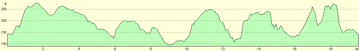
Distances
| From | To | Distance (m) | Ascent (ft) | Descent (ft) |
|---|---|---|---|---|
| Clare | Long Melford | 10.0 | 358 | 384 |
| Long Melford | Clare | 9.6 | 633 | 607 |
This makes a total distance of 19.6 miles, with 991 feet of ascent and 991 feet of descent.
For more information on profiles, ascents and descents, see this page
Disclaimer
Please note that I take no responsibility for anything that may happen when following these directions. If you intend to follow this route, then please use the relevant maps and check the route out before you go out. As always when walking, use common sense and you should be fine.
If you find any information on any of these routes that is inaccurate, or you wish to add anything, then please email me.
All images on this site are © of the author. Any reproduction, retransmissions, or republication of all or part of any document found on this site is expressly prohibited, unless the author has explicitly granted its prior written consent to so reproduce, retransmit, or republish the material. All other rights reserved.
Although this site includes links providing convenient direct access to other Internet sites, I do not endorse, approve, certify or make warranties or representations as to the accuracy of the information on these sites.
And finally, enjoy your walking!
Nearby walks
| # | Title | Walk length (miles) |
|---|---|---|
| 105 | Newmarket to Bury St Edmunds | 21.7 |
| 589 | Great Shelford to Haverhill | 16.9 |
| 694 | A circular walk from Clare to Suffolk county top | 19.6 |
|
|

|