Walk #647: A circular walk from Oundle to King's Cliffe
 |
 |
|
General Data
| Date Walked | 12/02/2005 |
| County | Northamptonshire |
| Start Location | Oundle |
| End Location | Oundle |
| Start time | 09.10 |
| End time | 15.54 |
| Distance | 19.6 miles |
| Description | This was an enjoyable stroll, taking in part of the Nene Way before heading back through areas of woodland towards Oundle. |
| Pack | Today I carried my 70-litre Craghoppers WildPlaces rucksack, with full camping kit minus spare clothes, food and cooking equipment. |
| Condition | I have had significant problems on this walk - after about fifteen miles I started getting a sharp pain in the left-hand side of my groin, and as I continued n this got increasingly worse. Eventually I could hardly lift my left leg up, and I hobbled along the road for the last three miles. I think this was caused by a slight injury I got lifting something on Tuesday, and hopefully it will recover quickly. |
| Weather | The wind was the main feature of today's weather; it was quite fierce and when it caught my rucksack it would blow me about. Fortunately the wind was not cold and I never really felt chilly, despite having no fleece on (my coats kept me warm enough). There was a little rain towards the end of the day, although this was thankfully never heavy. |
| OS map | Landranger number 141 (Kettering, Corby & surrounding area) and Landranger number 142 (Peterborough, Market Deeping & Chatteris) |
 |
 |
|
 |
 |
|
Map of the walk
Maps courtesy of Google Maps. Route for indicative purposes only, and may have been plotted after the walk. Please let me have comments on what you think of this new format. For a detailed table of timings for this walk, please see the table file.
 |
Notes
Before today I had not done a walk for over two weeks, and I was therefore more than a little keen to get out and stretch my legs despite the windy weather outside my window. It is a relief that spring is coming and the days are lengthening, as it means that I can travel to and from a walk in the daylight and not have to drive in the dark. The traffic on the A14 was light, and I soon found myself arriving in Oundle. I was unsure where to park, and eventually I found my way to a small long-stay car park on the northwestern side of the town.
The wind was still blowing strongly and it looked as though it could rain, so I decided to put my coat and waterproof trousers on. Despite the wind it felt quite warm, and I decided to walk without a fleece - this proved to be a good idea, as I was generally warm enough as it was. Oundle was reasonably busy, and the market place was bustling with people around the stalls of the small Saturday market. There was a stall selling organic beef burgers that looked extremely tempting, but I resisted and headed on eastwards along local roads. Shortly after passing a supermarket I reached a dead-end road; here a kind gentleman pointed me down the correct path; not an obvious one that led through to a Royal Mail depot, but another one that soon reached the A605 road.
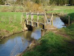
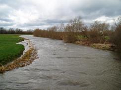
Once across the road I soon reached a fairly ugly and seemingly massively over engineered bridge over the River Nene, the large green pipe work beams spanning the river inelegantly. The river under the bridge was quite full and was flowing fast, a symptom off the recent heavy rain. Almost immediately after the bridge I reached an old mill, now sadly boarded up, but which had a wall artistically furnished with a series of iron wall ties. This made for a lovely sight, and I cannot imagine such an attractive building being unused - or unconverted - for too long.
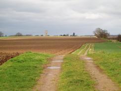
Ashton was a superb little village, with the thatched limestone houses being reminiscent of Cotswold villages, although without some of the obvious charm. It is certainly a place that I would not mind living, although I could not find the pub marked on the Ordnance Survey map. From the village I followed the Nene Way, which followed a track north eastwards, passing Oundle School's rifle range on the way. This track became exceptionally muddy after a while, and this, coupled with the strong, gusty wind and my high-sided pack, meant that I had to struggle not to get blown over. I was very relieved when I reached a road that led me on into the village of Warmington.
When compared to Ashton this village did not exactly shine, and I rushed through, making for a little tunnel bridge under the A605 that led towa4ds a branch of the River Nene. This was crossed beside another mill - this time converted and in-use, and next to a fast-running flume of water that was quite fascinating to watch. A path across a boggy field led to another branch of the Nene beside a lock, the upper gates of which were being overflowed by water. The path then headed on, crossing fields and an old railway line embankment before reaching the prominent motte and bailey mounds of Fotheringhay Castle. It was here in 1452 that Richard III was born and, more famously, it was here that Mary, Queen of Scots was executed on the 8th February 1587. All that remains of the castle are the mounds, the ditch and a small piece of the keep, which I did not see as I did not climb the mound. I knew that nothing remained of the castle but I was still surprised by how comprehensively it had been removed; many castles still have at least some walls remaining. It was quite reminiscent - if grander - than the castle mound in Cambridge, which had never had a stone tower on it.
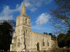
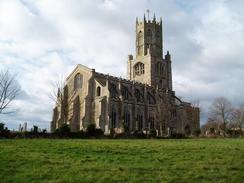
Fotheringhay Church was a grand structure but looked slightly odd to me - it was only after I had been looking at it for a while that I realised that it was out of proportion. The building is extremely grand with buttresses soaring from the aisles past the clerestory, but also short for it's height, making it seem as if the Nave was once much longer. Despite the proportions, however, it is an artistic delight, and only the state of my boots, with mud clods hanging off, prevented me from going in for a look around. I left the village along a road, and at the end of this I left the Nene Way, which headed off to the north. Instead I took a footpath that headed across fields before reaching a footbridge over the unspectacular Willow Brook and entering Woodnewton.
I did not really find much of interest in this village aside from the church which, whilst not as spectacular as that at Fotheringhay, was nice nonetheless. A long road walks took me on into Apethorpe, where I was overtaken by a bunch of youths in army fatigues whilst I studied the Apethorpe Stocks, the oldest and most complete set of original stocks in Northamptonshire. There is also a whipping post and a stocks bench, which I found to be a fascinating insight into the way the country really used to be. Instead of following the road into King's Cliffe I decided to take a footpath, and whilst this made for a more interesting walk it did expose me to the fierce wind and muddy ground underfoot, which caused me to struggle slightly as I walked. South of the village the path crossed a very disturbed area of ground, which I can only assume is the remains of an old mine (perhaps one of the once abundant Northamptonshire iron ore quarries?) Near this I had to cross a stile that was guarded by a wooden board that was set just below my chest height; I could not climb over it and I had to crawl on all fours under it due to the height of my rucksack. This was annoying, and made me even muddier.
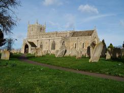
Just before entering King's Cliffe I crossed the Willow Brook once more near an old mill before climbing up a slight hill to the church, which was another nice building. Indeed, I soon found that King's Cliffe was full of nice buildings, and the village had a lovely atmosphere. I was sorely tempted to nip into the pub for a quick pint, but the condition of my clothes and boots dissuaded me. I walked on through the village enjoying the nice atmosphere and looked down a couple of almost impossibly narrow alleyways - I would have had trouble getting down them with my rucksack on. A shop proved irresistible and I went in to purchase some chocolate and a packet of crisps, which I devoured ravenously as I headed out of the village.
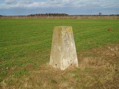
After crossing the Willow Brook for the third and last time of the day I took a track that headed up to a farm before becoming boggier as it progresses south westwards, The footpath to Spa Farm that is marked on the map proved hard to find, and I chose instead to take a fenced in path that had obviously taken several horses recently if the churned up ground was anything to go by. This approached Spa Farm but was going too far east, so I cut across a field and reached a track right by the eastern side of the farm. My next target was the Spa Farm trig pillar to the west, and as I walked past the farm the full fury of the wind hit me as the ground became boggier. If not actually difficult, progress was hard, and I soon felt a twinge in my left hip. By the time I reached the pillar the twinge had become pain, and even the discovery that the flush bracket was marked S6789 did not help.
I turned back and followed the track past Spa Farm and on towards another house, before turning off and walking along a footpath that ran along the western side of Tomlin Wood. The wood protected me from the wind somewhat, but the pain in my hip was, if anything, increasing. I was relieved when I joined a track that ran along the southern end of the wood, and I soon made a navigational mistake by heading too far along the track towards Lodge Farm. Instead of heading back I crossed a freshly ploughed and boggy field to rejoin a footpath that headed along the western side of a linear path of woodland before entering a much larger wood. This path was easy to follow and had recently been widened due to some clearance work. There little patches of blackness where fires had been used to burn off small kindling, and these smelt fairly recent.
The path swung round through the woodland, headed down a short field before and across a plank bridge over a stream before dumping me unceremoniously on a road beside the church in Southwick. By this time the pain in my hip was causing me to limp, and as I headed along the road towards the water tower at the top of the hill I was limping, as lifting my left foot up enough to climb the hill caused me sharp pains. Despite this I did not slow down too much and I found a gait that did not cause me to suffer too much. I was relieved when the summit came and I started the descent down past Gaythorn. The descent was far easier as I did not need to lift my left foot too much, and I was annoyed when another slight hill led me up and into the outskirts of Oundle.
I found the walk along the road through Oundle to be almost interminably long, and even the interesting buildings belonging to Oundle School that lined the road could not distract me from the fact that I was by this time in pain. I walked on, reaching the High Street by the war memorial, and had a final few hundred yards back to the car. I took these slowly, and was ecstatic when I finally reached the car. I took my rucksack off and found that the pain disappeared; I could walk freely. This is still fairly worrying, however, and I may do the next few walks with a much-reduced load to see how I go.
Directions
This walk starts off at a car park beside Milton Road, on the western side of the town of Oundle. Leave the car park and turn left, to walk a hundred yards down Milton Road to reach the junction with the A427 West Street by an unusually-shaped church. Here turn left and start following the A427 eastwards through the town. When the marketplace is reached on the right turn right down St Osyth's Lane, before taking the first road to the left, East Street, which passes a supermarket on the left. When a junction is reached, turn right down Ashton Road. Immediately before the road ends turn left along a footpath that heads eastwards to the A605; cross this and then continue eastwards towards a bridge over the River Nene. The path is easy to follow as it crosses the bridge and then passes under a mill to reach a minor road. Continue on along a footpath up a slight hill, and when this ends at a road in Ashton continue on along the road through the village.
On the eastern side of the village the road ends and a bridleway continues on to the left. Follow this bridleway, which follows the Nene Way, as it heads slightly east of north for a couple of miles into the village of Warmington. The bridleway jinks to the right for a few yards before meeting a road that heads off to the left before ending at another road. Turn right along this road before taking the first road off to the left, which heads northwards through Warmington. When a pub is reached at the northern end of the village turn left and walk down a road that soon ends at an underpass under the A605. Go under the A605 and once on the other side follow a path for a few yards to reach an old converted mill. Follow the Nene Way over the river, and then on northwards across a field to reach a bridge over a tributary of the river. A little further on another bridge is reached over the main river at a lock; cross the bridge and once on the other side follow a footpath that heads northwestwards, passing the motte and bailey of Fotheringhay Castle before entering the village of Fotheringhay itself.
Once in Fotheringhay follow the road as it curves around past the church; when the road forks at the western end of the village take the right-hand fork that heads northwestwards until a footpath is reached on the left. Here the Nene Way is left for the day as my route takes this footpath, which heads for a short distance northwestwards across a field to reach a minor road. Cross this, and once on the other side take another footpath that heads northwestwards, crossing Willow Brook before joining a track that shortly ends at a road junction in Woodnewton. Turn right for a few yards before following the road as it swings around to the left past the village sign to head northwestwards. Once the road passes the church turn right to follow another road northwards for a hundred yards until it ends at another junction. Here turn left, and follow another road as it heads northwards for a mile before swinging around to the left to reach Apethorpe Church.
At the church follow the road as it swings around to the right to head westwards for about a hundred yards to another junction; turn right to head north along this for a few yards and then turn left along a track that heads westwards. After about a hundred yards turn right to join a footpath that heads northwestwards for about a kilometre before curving to the right to head on a more northerly course, climbing up to cross a highly disturbed area of land before heading downhill. When a rough track is met turn left to follow it for a few yards before taking a footpath that leads off to the right, heading across a small field before reaching a bridge across the Willow Brook. Cross the bridge and on the other side continue on to meet a track that soon ends at a road beside King's Cliffe Church. Turn left to follow the road westwards through King's Cliffe until it ends at a junction at the western end of the village.
At the junction turn left to head southwards along a track that crosses Willow Brook before reaching a farm; at the farm the track curves to the right to head southwestwards. After a little under a kilometre a footpath leads off to the left; this proved to be very hard to find on the ground and I took a clear path that had been used by horses that proved to head too far eastwards. For these reasons make your own way to the track that runs through Spa Farm, and then turn right to walk westwards along a distinct but unfenced track for a couple of hundred yards to a trig pillar. Once there turn back and head back towards Spa Farm. Pass through the farm and continue on along the track until it reaches the edge of an area of woodland, where the track turns to the right to head southeastwards. After a couple of hundred yards the track enters some woodland; at this point turn right and join a footpath that heads south alongside the western edge of Tomlin Wood.
When the southern edge of the woodland is reached after about a kilometre a track is reached; turn left along this track and follow it as it heads east along the southern edge of the woodland. Once the eastern edge of the woodland is reached turn right along a footpath that heads south across a field, before skirting the western edge of a thin layer of woodland. When this meets a large expanse of woodland the footpath joins a track that climbs uphill as it heads slightly east of southwards. The footpath crosses a track before turning to the left to head eastwards. The path soon joins another track, and just before this reached the eastern edge of the woodland turn right down a footpath that heads south through the woodland before emerging out into a field. Continue south along the footpath as it descends down to a stream. Cross the stream on the footbridge and continue on until a road is reached beside the church in Southwick.
At the road turn left for a few yards and then turn right up another road; this heads uphill in a slightly east of south direction towards a large and imposing water tower before descending downhill towards a crossroads to the east of Glapthorn. Continue straight on at the crossroads and follow the road as it heads southeastwards, rising uphill before entering Oundle. The road continues on southeastwards before ending at a junction with the A427 by the war memorial in the centre of Oundle. From here it is simply a case of retracing your steps from first thing this morning, heading westwards through Oundle along the A427 until the church is reached, and then turning right up Milton Road back towards the car park.
Distances
| From | To | Distance (m) | Ascent (ft) | Descent (ft) |
|---|---|---|---|---|
| Oundle | Fotheringhay | 5.7 | 131 | 171 |
| Fotheringhay | King's Cliffe | 4.9 | 240 | 170 |
| King's Cliffe | Oundle | 9.0 | 541 | 571 |
This makes a total distance of 19.6 miles, with 912 feet of ascent and 912 feet of descent.
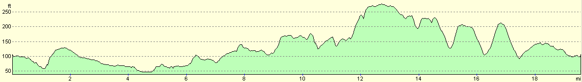
For more information on profiles, ascents and descents, see this page
Disclaimer
Please note that I take no responsibility for anything that may happen when following these directions. If you intend to follow this route, then please use the relevant maps and check the route out before you go out. As always when walking, use common sense and you should be fine.
If you find any information on any of these routes that is inaccurate, or you wish to add anything, then please email me.
All images on this site are © of the author. Any reproduction, retransmissions, or republication of all or part of any document found on this site is expressly prohibited, unless the author has explicitly granted its prior written consent to so reproduce, retransmit, or republish the material. All other rights reserved.
Although this site includes links providing convenient direct access to other Internet sites, I do not endorse, approve, certify or make warranties or representations as to the accuracy of the information on these sites.
And finally, enjoy your walking!
Nearby walks
| # | Title | Walk length (miles) |
|---|---|---|
| 56 | Peterborough to Stamford | 16.5 |
| 58 | Stamford to Oakham | 16.8 |
| 643 | A circular walk from Thrapston to Oundle | 19.4 |
|
|

|