Walk #646: A circular walk around Newport and Clavering
 |
 |
|
General Data
| Date Walked | 24/01/2005 |
| County | Essex |
| Start Location | Newport (Essex) |
| End Location | Newport (Essex) |
| Start time | 08.26 |
| End time | 14.48 |
| Distance | 19.3 miles |
| Description | This is an enjoyable circular walk around Newport in Essex, and although it does not go very high I still enjoyed it immensely. |
| Pack | Today I carried my 70-litre Craghoppers WildPlaces rucksack, with full camping kit minus spare clothes, food and cooking equipment. |
| Condition | I feel quite tired after this walk, and carrying a heavy pack for the second day in a row meant that my shoulders and legs are quite stiff. However with a little rest I could quite easily have walked further, which is a good sign for the walks that I have planned for later on the year. |
| Weather | The weather today was quite mixed, with sunny periods interspersed with cloud, and hil, rain and snowstorms. One snowstorm in particular lasted for about half an hour and was quite fierce. The most constant feature of the weather was the wind, which was quite cold and made me feel quite chilly when I was exposed to it. |
| OS map | Landranger number 154 (Cambridge & Newmarket, Saffron Walden) and Landranger number 167 (Chelmsford, Harlow & Bishop's Stortford) |
 |
 |
|
 |
Map of the walk
Maps courtesy of Google Maps. Route for indicative purposes only, and may have been plotted after the walk. Please let me have comments on what you think of this new format. For a detailed table of timings for this walk, please see the table file.
Notes
After the long drive to get to Kent for yesterday's walk I really did not fancy doing the same again today, especially through weekday rush-hour traffic. For this reason I opted to do a walk much closer to home, and I soon opted to do one that I had planned for some time, based on Newport in Essex. The main reason I designed this route was that it encompassed three trig pillars, but it seemed from the map to be a nice enough walk and so, later than I wanted, I set off for Newport.
The journey was longer than I had been expecting due to traffic levels, and I reached the car park at Newport railway station far later than I had wanted. It was a cold morning and it had been snowing overnight, and although there was only a slight scattering of snow at the station there was a fair amount of ice about as I walked through the town. I had last walked through the town in late 1999 as part of my Land's End to John O'Groats walk, and it felt strange to think about how many miles - nearly 10,000 - I had walked since then. I soon left the main road through the village and joined a narrow road which was busy with cars taking children to the school at the end; on several occasions I had cars pass closer to me than I really wanted, and I wondered how the parents in the car would feel if a car drove that close to their child.
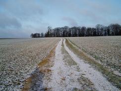
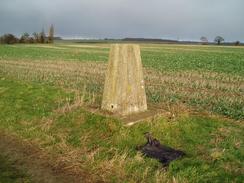
I was soon off that road, however, and I started along a track, initially surfaced, that led westwards following the Harcamlow Way, passing under the M11. Some of the ploughed fields were covered in snow, and the sight made me feel much better as I walked onwards towards my first objective, a trig pillar to the east of Arkesden. The pillar proved very easy to find, and the slight frosting of snow on the pillar made it attractive; if it had not been the noise from the nearby M11 it would have been a particularly nice scene. I did not hang around for too long, and instead took a path that led down into the village of Arkesden.
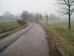
This was a pretty little village and I was amused to find that the pub had won an award recently. I admired some of the buildings as I walked along the road, and I was slightly disappointed when it took me out. The Harcamlow Way took me along the driveway leading to Chardwell Farm, and then along a footpath to Clavering Farm, where I opted to follow a track instead of the footpath, which zigzagged across a field immediately to the south. I left the Harcamlow Way when it reached an old Roman Road, and turned to follow it southwestwards until it ended on the road at Butts Green. By this time it had started to snow lightly, and as I walked along the road the snowfall got heavier.
I love walking through snow, and today was no exception, and the road walking became a joyful experience as I passed two windmills, which were just stumps and looked curiously dismembered without their sales. By the time I reached Clavering the snow was falling heavily, and I was disappointed when I crossed the B1038 road and it abruptly stopped. A pleasant footpath led me on eastwards across fields to my next target, a trig pillar that lies in a hedge right beside the footpath. I duly recorded the flush bracket number of the pillar and took some photographs before continuing on along the footpath towards Coldhams Farm.
Here route navigation became more problematic and I could find no trace of the footpath that is marked as running southeastwards from the farm to the road. I was loath to trespass in this particular situation, and so instead I followed he bridleway that ran along the access farm to the road. Unfortunately this meant that I had to walk back along the road to the point where the footpath would have emerged, and this little diversion annoyed me intensely, a mood that was not aided by the fact that when I reached the point the footpath reaches the road it was obvious that the footpath sign had been dismembered. I cannot claim to know that this was done by the landowners to stop people using the footpath, but the lack of signage by the buildings was certainly not aiding walkers.
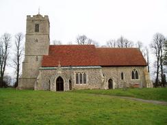
Rickling Church is located literally in the middle of nowhere, and I left me wondering exactly where its parishioners came from. It was a fairly attractive church although not outstanding, and I took a few photographs of it before heading on down the road towards Rickling Hall. It was not obvious from the Ordnance Survey map if there was a right of way connecting the footpaths to the north and south of the hall, but I decided to risk it and walked past the hall frontage and into the yard of the adjacent stables. Here I was stopped by a woman, who I chatted to before she told me there was actually no right of way through the farmyard. She was a very friendly lady, and as we chatted the horse she was holding by the reigns tried to get at an apple I had inside the breast pocket of my rucksack.
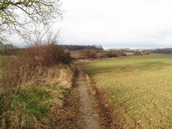
The next stretch of footpath was initially easy to follow as it ran along a track, but soon became harder as the track ended and I had to walk across fields. I eventually reached a road and followed this for a short distance before taking a footpath that led through Broom Wood and towards a main road. Once across this a road took me past the amusingly named village of Ugley and on, heading under the M11 and a low bridge under a railway line. Another road took me south of the hamlet of Little Henham before eventually petering out, and here I joined a track that initially followed the course of the River Cam or Granta, at this point little more than a stream. This stretch of path was quite enjoyable, and I was disappointed when the footpath left the stream and diverted off northwards, becoming muddier before ending at a road near Mole Hall.
A short footpath took me north towards the end of a road at Rook End, and from here I started heading west along a footpath towards Newport and the end of the walk. The path crossed a road by a farm at Waldegraves, and about half a kilometre further on I visited my third and last trig pillar of the day. This was situated in a field just to the north of the path on an access track to the farm at Ringers, and was easy to find. It felt nice to find the pillar so easily, and I duly recorded it before heading back to the track and descending along it down into Newport. As I did so it started to snow once more, and although this was not heavy it the experience of being out in the snow made me feel very happy.
The track eventually became a surfaced road and when this met the railway line at Newport Station a handy pedestrian footbridge took me over the line and platforms and back to the car park where the walk began. This had hardly been a classic walk but it had proved to be enjoyable nonetheless, particularly because of the snowy weather that had characterised the day.
Directions
This walk starts off at Newport railway station. Leave the railway station and walk westwards down the road, passing the car park before reaching the B1383 road. Turn right and start walking northwards up the B1383 through Newport until the junction with the B1038 road is reached. Turn left and walk west along the B1038, passing the church until a road leads off to the right on the western outskirts of the town. Turn right along this road and follow it as it heads northwards; when it ends at a T-junction turn left along a road that heads westwards. This road soon becomes a track that heads under the M11 on a bridge before crossing fields in a northwesterly direction.
When a track junction is reached beside a hedge turn left and start following another faint track uphill to the south for a couple of hundred yards. When another track junction is reached with a trig pillar to the left, turn right and start following another footpath. Initially this heads westwards before curving around to head southwestwards, descending down a hill with a hedge to the left before ending at a road in the village of Arkesden. Once the road is reached turn right and start following it as it heads northwestwards through the village. Once it leaves the village continue on along the road until the driveway for Chardwell Farm is reached on the left; turn left and follow the driveway towards the farm.
Just before the first farm building is reached the footpath turns to the right and follows the edge of fields around the buildings. It then heads off northwestwards away from the farm; after a few hundred yards turn left along another footpath that heads southwestwards, crossing a stream before reaching Clavering Farm. Walk immediately to the north of the farm and then follow a track that heads westwards across a field for about half a mile until a junction with a by-way (actually an old Roman Road) is reached, Turn left along this by-way and follow it as it heads southwestwards.
When the by-way ends at a road in Butt's Green turn left and start following the road; it passes a farm at Thurrocks before heading south-eastwards towards a T-junction at Roast Green. Turn left and follow a road as it heads eastwards, passing an old windmill stump before curving around to head southeastwards towards Clavering. Follow the road as it heads eastwards through the village until it ends at the B1038 road. Turn left along the B1038 for a few yards before turning right near a pub to head eastwards along a footpath. This footpath climbs uphill across fields and passes under some power lines before reaching a trig pillar embedded in a hedge. Here the footpath on the ground does not match that on the map; the one on the ground diverts off to the right, following the hedge southwards for a couple of hundred yards before turning left to follow a bridleway downhill to Coldhams Farm. At the farm follow the access driveway as it curves around to head eastwards towards a road.
Once at the road turn right and start following it southwards; just before a house is reached on the left turn left along a footpath that soon emerged out onto a road near Rickling Church. The church is positioned at a road junction; follow the road that heads southwards for a kilometre, and when it turns to the left continue straight on along the driveway that heads towards Rickling Hall. Just before the hall is reached turn left and walk past some stables before turning right to head south along another track that heads up a slight hill. When the edge of some woodland is reached a footpath leads off to the left; take this footpath and follow it as it heads southwards across fields before ending at a road. Turn left and start following the road as it winds around northeastwards for a few hundred yards until a footpath heads off to the right.
Turn right and follow this footpath as it heads south along a track; after a couple of hundred yards turn left and follow a footpath eastwards towards Broom Wood. Once the path meets the woodland it turns to head southeastwards through the woods along a clear path until it reaches the B1383 road opposite a pub. Cross the B1383 road and follow it as it heads eastwards to the north of the village of Ugley, passing under the M11 before ending at a T-junction. Turn right and follow a road as it heads eastwards, almost immediately passing under a railway bridge. When a road leads off to the left turn left and follow it as it heads northeastwards, passing to the southeast of Little Henham before it ends at a farm. A by-way continues on, initially following the northern bank of the River Cam before curving to head northwards and becoming muddy before it ends at a road near a road junction. Head north along a road for a short distance until Mole Hall is reached; the road ends and a track continues northeastwards for a few yards. When a building is passed a footpath leads off to the left; follow this footpath as it heads northwards across fields until it ends at a road at Rook End.
Walk along the road for a few yards before turning to the left to join a by-way that heads northwestwards for a little under a mile, skirting to the south of an area of woodland before reaching a road at Waldegraves. Turn left along the road for a few yards as it heads around a bend, and then turn right to head westwards along another by-way. The track is easy to follow as it winds around, passing immediately to the south of a trig pillar before descending downhill. The track eventually becomes surfaced as it heads northwestwards towards the railway station. When the road curves to head northwards by the station there is a footbridge; climb the footbridge to go over the platforms and gain access to the station car park, where this walk ends.
Distances
| From | To | Distance (m) | Ascent (ft) | Descent (ft) |
|---|---|---|---|---|
| Newport | Butts Green | 6.1 | 508 | 276 |
| Butts Green | Ugley | 7.3 | 302 | 400 |
| Ugley | Newport | 5.9 | 240 | 374 |
This makes a total distance of 19.3 miles, with 1051 feet of ascent and 1050 feet of descent.
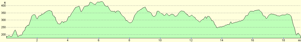
For more information on profiles, ascents and descents, see this page
Disclaimer
Please note that I take no responsibility for anything that may happen when following these directions. If you intend to follow this route, then please use the relevant maps and check the route out before you go out. As always when walking, use common sense and you should be fine.
If you find any information on any of these routes that is inaccurate, or you wish to add anything, then please email me.
All images on this site are © of the author. Any reproduction, retransmissions, or republication of all or part of any document found on this site is expressly prohibited, unless the author has explicitly granted its prior written consent to so reproduce, retransmit, or republish the material. All other rights reserved.
Although this site includes links providing convenient direct access to other Internet sites, I do not endorse, approve, certify or make warranties or representations as to the accuracy of the information on these sites.
And finally, enjoy your walking!
Nearby walks
| # | Title | Walk length (miles) |
|---|---|---|
| 10 | Waterbeach to Great Chesterford via Cambridge | 21.0 |
| 49 | Bishop's Stortford to Great Chesterford | 14.9 |
| 53 | Harlow Town to Bishop's Stortford | 9.8 |
|
|

|