Walk #578: A circular walk from Edale to Kinder Downfall and Rushup Edge
 |
 |
|
General Data
| Date Walked | 06/12/2003 |
| County | Derbyshire |
| Start Location | Edale car park |
| End Location | Edale car park |
| Start time | 08.28 |
| End time | 14.46 |
| Distance | 14.2 miles |
| Description | This was an entertaining and, in places, muddy walk, including Grindsbrook Clough, Kinder Downfall, Rushup Edge and Mam Tor. |
| Pack | Today I carried my 30-litre Karrimor HotRock rucksack, which was filled with my waterproof leggings, water bottle and a couple of spare shirts, together with the usual assortment of odds and ends. |
| Condition | Towards the end of the walk my left knee ached (probably as a result of the stone flags down from Mam Tor). Aside from this I was fine, and could easily have extended the walk if I had really needed to. |
| Weather | The main feature of today's weather was the wind, which was very strong and gusting in places where I was exposed to it. The day was mainly overcast, although fortunately with no sign of any rain, and there were occasional short-lived periods of sunshine. It was not a cold day, although the wind could make it quite chilly. |
| OS map | Outdoor Leisure number 1 (The Peak District - Dark Peak Area) |
 |
 |
|
 |
 |
|
Map of the walk
Maps courtesy of Google Maps. Route for indicative purposes only, and may have been plotted after the walk. Please let me have comments on what you think of this new format. For a detailed table of timings for this walk, please see the table file.
 |
 |
|
Notes
The main aim of this walk was to do the Kinder round walk, which is about twenty miles in length, taking in the entire perimeter of the Kinder Plateau. This is just about possible at this time of year (the length of day being a problem), and so as the weather forecast for today was quite positive I set off just before seven for the forty-mile drive to Edale. I arrived shortly after dawn, but I was dismayed to see a very overcast sky and the trees in the car park being blown about. After chatting to a fellow walker who was also preparing to go on to the plateau, I decided against doing the round and simply doing a walk to Kinder Downfall instead.
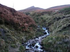
I decided that instead of taking my normal route via Jacob's Ladder and the Pennine Way, I would follow the old route of the Pennine Way, which follows Grindsbrook Clough on to the plateau. This got me onto the plateau far quicker than the alternative route, and also gave me the opportunity to walk part of the southern edge of the plateau, which I had not done since my schooldays. Initially the climb up the path was exceptionally easy and there were stone slabs underfoot once I had crossed the stream on a nice footbridge, but this soon ended and as I got nearer to the top of the climb the going became increasingly harder, although never very bad. I was quite glad when I reached the top, however, and I could start the walk along the edge of the plateau.
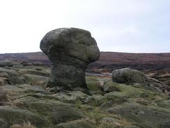
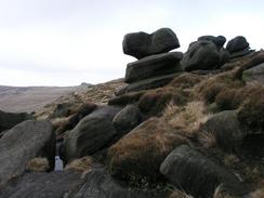
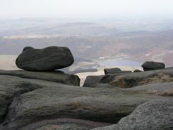
The southern edge of the plateau is marked by a series of dramatic rock formations - large rocks balancing on smaller ones, as though they have been carefully placed there. Whilst I tried to take photographs of one of these called Pym Chair I slipped over on the slippery mud and my camera went for the ground lens first; this pushed the zoom lens housing back into the camera, but fortunately appeared to cause no other harm! When I eventually met the Pennine Way I turned to the right and started to follow it northwards across the moorland. I have walked this route many times before, and so instead of following the official route I kept slightly to the west of the Pennine Way route for the first stretch, joining it again north of the rocks at Kinder Low. I walked on via Red Brook to Kinder Downfall, a waterfall that fortunately was flowing (often it is totally dry).
I had planned to have lunch by the waterfall, but the wind was extremely chilly and so after a short rest I started on back again. I tried to keep up a good pace to keep myself warm, and my thick gloves certainly helped keep my hands roasty-toasty. I went up to the trig point on Kinder Low, and then decided to alter my route again, taking a stone slab path past Swine's Back to Edale Cross. When I reached the cross (a national monument half-hidden by the adjacent stone wall) I was still feeling very fit, and so I decided not to walk directly back to Edale via Jacob's Ladder, and to walk on to Rushup Edge. Edale Cross is quite interesting - it was erected by Cistercian Monks from Holywell in Flintshire as a boundary marker. It eventually fell down, but a Mr Thomas Gee of Ashes Farm re-erected it in 1810, also carving their initials into it. Initially the path from Edale Cross was easy to follow, but the stone slabs soon ended and I was faced with walking through some thick waterlogged black peat. The wind did not help matters, and my lower legs soon looked like part of the environment, the thick peat sticking to my gaiters.
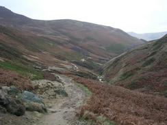
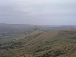
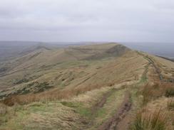
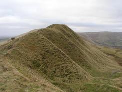
The trig point at Brown Knoll (569 metres) was particularly unwelcoming, and so I hurried on along the path, which increasingly became worse underfoot. I was glad when I reached the Chapel Gate track, but motorbikes, some of which were roaring along the track, had torn even this up. Instead of heading down it into Edale I walked onwards to the end of the path from Rushup Edge, and then started walking along this lovely ridge walk. The wind was troublesome here and made the walk quite unenjoyable, and I did not wait around at Lord's Seat, from where the views down the Edale valley are tremendously expansive. I quickly made my way down to the road at Mam Nick, and started the climb up the stone steps to the trig point at the top of Mam Tor (517 metres).
Again, the wind here was very strong, and so I started on along the slow descent along the Castleton ridge. The stone path proved hard on my legs, and my left leg soon started aching from the impact of my feet. At Hollins Cross I was faced with a choice; I was tempted to continue along the ridge to Lose Hill, but I would have had to walk back on myself, and I did not fancy doing this. Instead I headed straight downhill past the farm at Hollins, and I soon found myself back at the car park in Edale. As I had finished the walk much earlier than I had intended I decided not to camp out, as I had been planning, and to drive back home as there was plenty of daylight left. Before this, however, I went to the café beside the station in Edale for a quick meal - a fry up that was very welcome and did not stay on the plate for very long before I ravenously wolfed it down. All in all this was a superb walk, although I could really have done without the wind.
Directions
This walk starts off at the car park opposite the station in Edale. Leave the car park by the exit to the left of the public toilets and turn right to walk up the road, passing under the railway line. Continue on uphill past the Nags Head pub until the public road ends at a gate. Here turn right and descend down a short distance to a footbridge over a stream before climbing up steps into a field. Turn left and follow the obvious path of stone slabs as it heads through the field. At the end of the field the path enters access land and the slabs end; the path is easy to follow however as it climbs up with Grind Brook to the left. As it climbs higher the path becomes increasingly rough and less distinct, and the last part of the climb is quite steep before the path brings you out onto the southern edge of the Kinder Plateau.
At the top of the climb a path of stone slabs leads off to the west; I however headed along a path southeastwards to Grindslow Knoll before curving to head west-northwestwards along the edge of Kinder Scout. The path is obvious and easy to follow as it passes Crowden Tower, the Woolpacks, Pym Chair and Noe Stool (all rock formations resembling their names) before heading southwestwards to meet the course of the Pennine Way immediately to the north of Swine's Back by a cairn. Turn to the right and start following the Pennine Way northwards along the western edge of Kinder Scout, passing the trig point on Kinder Low before crossing Red Brook and reaching the waterfall at Kinder Downfall, where the River Kinder flows over the edge of the plateau.
From Kinder Downfall double back on yourself and start heading back towards the trig point on Kinder Low. At Kinder Low instead of heading along the Pennine Way take another path that heads slightly further to the west, heading across Swine's Back and reaching Edale Cross, which is hidden in an alcove behind a stone wall. From Edale Cross turn to the left to head westwards for a few hundred metres along a stone wall until you meet the Pennine Way at a crossroads in the paths at the top of Jacob's Ladder. At the junction turn right to start walking southeastwards across the moorland beside a stone wall. The initial part of the path is along a path of stone slabs, but these soon end and the path becomes very muddy as it heads across the peat moorland.
After a short distance the path curves to a more southerly course before turning to the left and crossing the stone wall and heading southeastwards to the trig point on Brown Knoll (569 metres). The path then continues on across the moorland, which is very boggy in places, before reaching a junction with the Chapel Gate track. Turn right and follow the Chapel Gate track south for a few hundred metres until it reaches a T-junction with another track. At this junction turn left and follow a path as it heads eastwards, starting the climb up to the summit of Rushup Edge at Lord's Seat. From Lord's Seat the path descends eastwards, becoming increasingly narrow as it descends, and a short but steep descent leads down to a road at Mam Nick.
From Mam Nick turn right along the road for a few metres, and then turn left to started the climb up the stone steps up to the summit of Mam Tor. Once the trig point on Mam Tor is reached start the descent down a path of stone slabs to the north; the path is obvious as it heads downhill, and the stone slabs end just before a little stone cairn is reached at Hollins Cross. Here turn left and descend steeply down a path to the northwest, which passes the farm at Hollins before joining a track near Peter Barn. The track heads north-northwestwards, crossing the River Noe just before it ends at a road. Turn left down and follow the road westwards, crossing Yeomans Bridge before reaching the car park in Edale on the right, where this walk ends.
Distances
| From | To | Distance (m) | Ascent (ft) | Descent (ft) |
|---|---|---|---|---|
| Edale car park | Kinder Downfall | 5.8 | 1764 | 587 |
| Kinder Downfall | Chapel Gate track | 4.5 | 430 | 781 |
| Chapel Gate track | Edale car park | 3.9 | 440 | 1266 |
This makes a total distance of 14.2 miles, with 2635 feet of ascent and 2634 feet of descent.
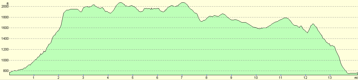
For more information on profiles, ascents and descents, see this page
Disclaimer
Please note that I take no responsibility for anything that may happen when following these directions. If you intend to follow this route, then please use the relevant maps and check the route out before you go out. As always when walking, use common sense and you should be fine.
If you find any information on any of these routes that is inaccurate, or you wish to add anything, then please email me.
All images on this site are © of the author. Any reproduction, retransmissions, or republication of all or part of any document found on this site is expressly prohibited, unless the author has explicitly granted its prior written consent to so reproduce, retransmit, or republish the material. All other rights reserved.
Although this site includes links providing convenient direct access to other Internet sites, I do not endorse, approve, certify or make warranties or representations as to the accuracy of the information on these sites.
And finally, enjoy your walking!
Nearby walks
| # | Title | Walk length (miles) |
|---|---|---|
| 13 | Edale and Kinder Scout | 11.0 |
| 19 | Castleton circular via Lose Hill and Mam Tor | 7.7 |
| 23 | The Limestone Way from Pomeroy to Castleton | 14.0 |
|
|

|