Walk #577: A circular walk including Dovedale
 |
 |
|
General Data
| Date Walked | 04/12/2003 |
| County | Derbyshire, Staffordshire |
| Start Location | Dovedale car park |
| End Location | Dovedale car park |
| Start time | 10.40 |
| End time | 13.43 |
| Distance | 6.5 miles |
| Description | This was the shortest walk that I have done for some time, but nonetheless it was still a walk that was well worth doing. |
| Pack | Today I carried my 30-litre Karrimor HotRock rucksack, which was filled with my waterproof leggings, water bottle and a couple of spare shirts, together with the usual assortment of odds and ends. |
| Condition | As is to be expected from such a short walk, I felt absolutely fine at the end of it, although I again had trouble with the toes on my left foot, as I did on the longer walk two days ago. |
| Weather | It was a very overcast day and the sun never deigned to make an appearance. Fortunately it did not rain, however, and it was reasonably warm for the time of year. All in all it was not a bad day for a short stroll. |
| OS map | Landranger number 119 (Buxton & Matlock, Bakewell & Dove Dale) or Outdoor Leisure number 24 (The Peak District - White Peak Area) |
 |
 |
|
 |
Map of the walk
Maps courtesy of Google Maps. Route for indicative purposes only, and may have been plotted after the walk. Please let me have comments on what you think of this new format. For a detailed table of timings for this walk, please see the table file.
Notes
The most obvious thing to say about this walk was it's length - at a little over six miles, it is the shortest walk that I have done for some time. It was, however, also one of the nicest walks that I have done in recent times. The main reason for the walks brevity was that my sister Sue, wanted to do a walk with me, and due to childcare commitments we could not get a massive amount of time out on the hills.
When I was planning this walk I was very keen to do the Castleton ridge walk if the weather was clear - a superb introduction to walking in the Peak District. This was fairly impractical, however, as we did not have enough time to get up to Castleton and back again. Instead I chose to go to Dovedale, and to do a walk based on the River Dove. I was unsure about how far Sue called walk, and so I did not plan the walk and chose to play it by ear.
Dovedale is a truly superb place, and it is on that I have walked in many times when I was a child and at school. I do, however, try and avoid it as whenever the weather is nice the dale is filled with tourists. In summer this is a particular problem, and often there are coaches queuing up to disgorge people into the dale. For this reason I had not walked in the dale for years, and it was with some trepidation that I chose the dale as the base for a walk - I really could not face the crowds.
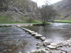
I was relieved when we pulled up in the car park at the southern end of the dale and saw that there was only four or five other cars in the car park, It usually costs money to park, but the booth was not open and so we could park for the day for free. It was obvious that the time of year and cloudy skies had out many people off, and so I was happier as we pulled on our boots (mine muddy from the walk I did a couple of days ago) and set off down the motorway-like path to the base of Thorpe Cloud and the stepping stones over the River Dove.
The area around the base of the stepping-stones was full of children (obviously dropped off from a coach), and so after pausing to take a couple of photographs we hurried off further up the valley. At the stones I was tempted to have a quick walk up to the top of Thorpe Cloud (the site of my one and only asthma attack when I was a child), but Sue was understandably not keen and so we strode on along the path further into the valley. We soon came to the reason why Dovedale is so famous - some of the rock formations are absolutely fantastic.
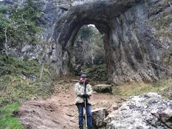
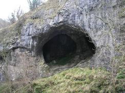
The first climb took us up the ominously-named Lover's Leap, where a bare rock formation juts up over the river, seemingly far below. Lover's Leap overlooks some dramatic rock pinnacles on the other side of the river called the Twelve Apostles. The descent soon took us past Tissington Spires and to Reynard's Cave, which is on the steep hillside above the path. We both climbed up to the mouth of the cave, which has an arch in front of it, to pose for some photographs. Reynard's Cave is a most impressive scene, although unfortunately my photographs of it did not come out very well.
We passed the footbridge that marks the entrance to Hall Dale to the left, and continued on up the valley until we hit the road at Milldale. Here we had a decision to make; we could either walk back the way that we had come through Dovedale, or we could make a circular walk by climbing up to the west of the valley. Sue was not keen to walk back the way that we ha come, and so we started the climb out of Milldale. The initial stretch was quite steep, but it soon slackened off and we were soon heading southwestwards across fields.
Near Damgate we joined a road, and this allowed us to have a good chat as we walked along. After a short distance we left the road and joined the footpath that led around the end of Bunster Hill; a superb little stretch of footpath, before descending down past the Izaak Walton Hotel back to the Dovedale car park. I asked Sue if she wanted to climb Thorpe Cloud as a nice end to the walk, but understandably she was not keen, so we retired to the Izaak Walton Hotel for a quick bite to eat.
Although this walk was very short by my standards, it was highly enjoyable. It was the first time in years that I had actually walked with someone, and it was exceptionally nice to be able to chat as we walked along. It appears that Sue enjoyed it as well, and so I can see us doing some more walks together sometime in the near future.
Directions
This walk starts off at the car park at the very southern end of Dovedale at the end of the road that leads past the entrance driveway to the Izaak Walton Hotel. Leave the car park and turn right to join the footpath that leads into Dovedale. Pass the water gauging station and head onwards past Thorpe Cloud and the stepping-stones.
A short and steepish climb takes you up to the top of Lover's Leap, with some great views over the river below. This is followed by a descent back down to the river level, and the path sticks more or less at this level as it heads north past Reynard's Cave and on to the stone bridge over the River Dove at Milldale.
Cross the bridge and join the road in Milldale, turning left to start climbing uphill along the road. After a couple of hundred yards turn left along a footpath that heads steeply uphill. At the top of the hill the footpath heads southwestwards across fields. It soon meets a track coming in from the left from Stanshope Pasture.
Join this track and follow it for a few yards, before turning to the left along another footpath that heads southwestwards for a short distance to a junction with another footpath coming out of Halldale. At this junction take another footpath that heads southwards across fields, eventually ending at a road to the south of the farm at Damgate.
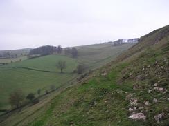
Once at the road turn left and follow it southwards for around a kilometre. When a track comes in from the left follow it for a few yards, and then turn to the right down another footpath that heads south-southeastwards to the corner of the woodland at Moor Plantation. The path then skirts around the edge of Bunster Hill, climbing up slightly as it does so, and summits on the hillside near a stone outcrop.
Descend down Bunster Hill along the obvious path to the southeast, and once on more level ground head across fields southeastwards to the Izaak Walton Hotel. The path then curves to head northeastwards back to a road, directly opposite to the entrance of the car park where this walk started.
Distances
| From | To | Distance (m) | Ascent (ft) | Descent (ft) |
|---|---|---|---|---|
| Dovedale car park | Milldale | 3.2 | 1102 | 997 |
| Milldale | Dovedale car park | 3.3 | 591 | 696 |
This makes a total distance of 6.5 miles, with 1700 feet of ascent and 1693 feet of descent.
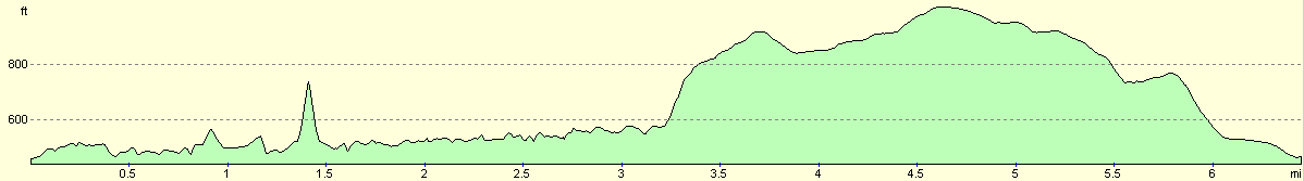
For more information on profiles, ascents and descents, see this page
Disclaimer
Please note that I take no responsibility for anything that may happen when following these directions. If you intend to follow this route, then please use the relevant maps and check the route out before you go out. As always when walking, use common sense and you should be fine.
If you find any information on any of these routes that is inaccurate, or you wish to add anything, then please email me.
All images on this site are © of the author. Any reproduction, retransmissions, or republication of all or part of any document found on this site is expressly prohibited, unless the author has explicitly granted its prior written consent to so reproduce, retransmit, or republish the material. All other rights reserved.
Although this site includes links providing convenient direct access to other Internet sites, I do not endorse, approve, certify or make warranties or representations as to the accuracy of the information on these sites.
And finally, enjoy your walking!
Nearby walks
| # | Title | Walk length (miles) |
|---|---|---|
| 14 | Friden, Long Dale and Gratton Dale | 7.8 |
| 24 | The Weaver Hills | 6.0 |
| 69 | Doveridge to Thorpe | 14.9 |
|
|

|