Walk #576: A circular walk from Winster to Youlgreave, Haddon and Rowsley
 |
 |
|
General Data
| Date Walked | 02/12/2003 |
| County | Derbyshire |
| Start Location | Winster car park |
| End Location | Winster car park |
| Start time | 09.15 |
| End time | 15.04 |
| Distance | 14.3 miles |
| Description | This was an absolutely superb walk taking in many interesting places; Robin Hood's Stride, Nine Stones Close, Haddon Hall and the Nine Ladies Stone Circle. There was a veritable feast of antiquities on this relatively short stroll. |
| Pack | Today I carried my 30-litre Karrimor HotRock rucksack, which was filled with my waterproof leggings, water bottle and a couple of spare shirts, together with the usual assortment of odds and ends. |
| Condition | Aside from a slight pain in the little toe of my left foot, I feel absolutely fine after this walk, and I could easily have extended it if necessary. |
| Weather | The weather today was generally overcast, with a low cloud layer that fortunately never descended to the level that I was at. It was quite warm for the time of year due to the cloud, but the low cloud meant that there was a haze that spoilt many of the views. |
| OS map | Landranger number 119 (Buxton & Matlock, Bakewell & Dove Dale) or Outdoor Leisure number 24 (The Peak District - White Peak Area) |
 |
 |
|
 |
 |
|
Map of the walk
Maps courtesy of Google Maps. Route for indicative purposes only, and may have been plotted after the walk. Please let me have comments on what you think of this new format. For a detailed table of timings for this walk, please see the table file.
 |
Notes
I am unsure why I chose to do this walk before other, potentially more scenic walks. I had planed my first walk once I got my car back on the road to be a stroll further north in the Peak District, but during a pleasant half-hour route planning a few nights ago I came up with this route. The main reason for doing this walk was because when I walked the northern half of the Limestone Way in May 1999 I did not explore the area around Robin Hood's Stride, and I have regretted this for along time. I also realised that I could take in the Nine Ladies Close, the remains of a Neolithic stone circle, and also my favourite antiquity, the Nine Ladies stone circle on Stanton Moor. Thus the route almost planned itself, and giving myself into providence I decided to do this walk as soon as possible.
When I woke up this morning I was greeted with a grey sky, although the sun was breaking through in places. The forecast was for the weather to improve, and so I set off the thirty-mile drive to Winster and the start of the walk. Unfortunately when I got to Winster I was greeted with an overcast and hazy sky, and whilst it did not rain at all during the day the haze rather spoilt what should have been some expansive views, and also caused some of my photos to be rather under-exposed. Whilst this was annoying, I am still more than happy with what was a quite superb walk, and one that I will definitely do again on a nice, cloudless day. One of the funny things was that, even though it was quite a warm day for the time of year, I saw only four other walkers - a couple near Youlgreave and another couple sitting outside the Peacock Hotel in Rowsley. I find this quite strange, and it is a shame that so many people hang up their walking boots in winter.
After the heavy rain of the last few days I found all the track sand footpaths to be quite muddy, and I soon made the decision just to plough through the worst patches of mud rather than to spend time attempting to skirt around them. In the past I have fond that on a walk I can spend a long time skirting around mud and trying to keep clean, only to get myself filthy half a mile from the end of the walk! When the conditions are this bad then in my opinion there is very little point in avoiding the worst sections.
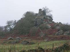
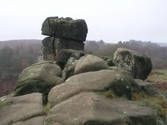
The limestone outcrops of Robin Hood's Leap soon came into view, and I started off by climbing up the little hillock to the east so that I could get some distant photos of the main outcrop. I then walked over to the Stride, which comprises of a large limestone outcrop covered in large boulders. Two parts of the outcrop are higher than the surroundings ones, and it is said that Robin Hood leaped between them - no mean feat, as they are separated by fifteen to twenty yards. It was a shame that the weather was not perfect, but even so it was quite a magical place to explore, with large slabs of rock leaning against others, forming little tunnels and caves.
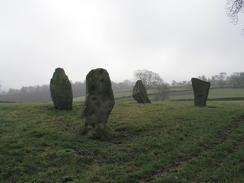
A few hundred yards away from Robin Hood's Leap is Nine Stones Close, four standing stones standing in an arc. These stones are quite magnificent, although it would have once been much more impressive - in 1847, there were seven stones upright (one of these missing stones is actually in a stone wall near Robin Hood's Stride! (Source: the excellent book 'The Modern Antiquarian', by Julian Cope, ISBN 0-7225-3599-6). There was quite an aura in the air by the stones and it is the sort of place that I could spend hours at, but after taking many photos I had to pull myself away and get on with the walk.
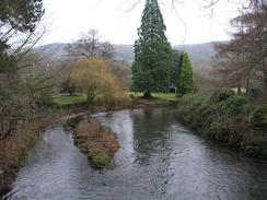
The short walk from Nine Stones Close to Youlgreave was quite enjoyable, especially a stretch that went though woodland to the prehistoric earthwork called Castle Ring. At the bridge over the River Bradford I left the Limestone Way, and started walking along the River Bradford to Alport, which was a nice walk spoilt by a motorway-style footpath underfoot. Near Raper Lodge I cross over the River Lathkill on an attractive bridge, before climbing over a hill and descending down to the A6 by Haddon Hall. This medieval stately home is quite a magnificent pile, although I am rather ashamed to admit that, despite having spent a great deal of time in the area over the years, I have never actually been in to look around it. Sadly at this time of year it was shut, and so I had to settle with a photograph of a gatehouse beside the road before continuing on the walk.
A little walk beside the River Wye was followed by a stiff climb along an estate road to the western portal of Haddon Tunnel. This tunnel used to carry the Midland Main Line to Manchester (known as the Peak Line) across Haddon Estate. The line closed in 1968, and the tunnel is now blocked off. It was rather an unnecessary tunnel, with a maximum depth of eleven feet, and was built by the cut-and-cover method. The only reason for the tunnel being there instead if a cutting was because the Duke of Rutland, who lives at Haddon Hall, did not want steam trains running through what is essentially his back garden! After the tunnel I climbed up to Bowling Green Farm, where there is an attractive and high-quality stone wall and steps with a driveway leading up from the Hall; obviously this was the site of one of the Duke's bowling greens!
Once I reached the high point on the hillside I descended rapidly, eventually joining a road that took me down past Rowsley Church, before it ended at the A6 road beside the Peacock Hotel. From here I was on ground that I knew well and that I had walked along before, so I kept up a good pace as I crossed the River Wye (almost directly beside its junctions with the River Derwent), before slowly climbing up the hillside to Stanton Woodcliffe Farm. Just before I reached the disused Endcliffe Quarry I came across some rather scruffy and jerry-built tents and structures on the scrubland. I knew instantly what these were; there are plans to reopen the Endcliffe Quarry, and the tents belonged to the protestors who are trying to stop the reopening. Now I am not someone who normally supports such protestors, but in this case I do; and indeed before I set off on my coastal walk I used to look at their website every so often. The quarry is being reopened without planning permission using a law dating back to the 1940's, and it is this more than anything else that I disagree with. The roads in the area are far from suitable for heavy stone lorries (there are already some quarries on the other side of Stanton Moor), and I cannot really see the point in reopening this quarry. They want to extract stone right up to the base of the Nine Ladies Stone Circle, which will certainly spoil the magical atmosphere of the Moor. I nipped into one of the tents to say hello to some of the protestors, and after a five-minute chat with them I set off once again for the climb up to the top of the moor.
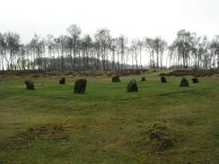
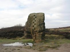
Once on the moor I walked to the tower (which, if I recall correctly was a shooting tower), before doubling back on myself to reach Nine Ladies Stone Circle. This stone circle is very unimpressive when compared to others, as the stones are very low and squat, but I have known the site for years, and I find it to be an absolutely magical place. There is an outlier stone, called the King's Stone, a short distance away, and I was glad to see that some new turf had been laid down between the main circle and the King's Stone; this had always been badly churned up and muddy in the past. Nine Ladies Stone Circle may not be very impressive, but it is by far my favourite Neolithic site, and I much prefer it to the massive grandeur of Stonehenge or Avebury. After taking a few photographs I left the circle, promising to return again soon, and made my way across the moors to a trig point, and then the Cork Stone. This standing stone is of a quite irregular shape and is much larger than the stones of Nine Ladies, and has stone handholds in it. In the past I have climbed up the Cork Stone and stood on top, from where in good weather there can be superb views, but I did not fancy trying to get up with my pack and boots on.
As I was on my way up the road back to the car park in Winster, I was extremely tempted to extend the walk by a couple of miles. In the end I decide against this, however, as there were no really attractive options to extend the walk, and I would be doing the extra distance only to increase distance, and not because I really needed to do it. Also, I knew that if I set off soon I would be able to get back home whilst it was still daylight. I normally call a fifteen-mile day short, but there was so much to see and do on this walk that I am very satisfied with the day's stroll, despite the fact that it was not very long.
Directions
This walk starts off at the car park at the upper end of East Bank in Winster, just above the village. Leave the car park and turn left to walk along the road towards the Miners Standard pub; when this road ends at a T-junction turn left onto the B5056 and then almost immediately right, past the curious lead ore house. Here the route joins the Limestone Way, which will be followed as far as Youlgreave. Follow this road for a few yards until another road comes in from the left, and then turn right down a track. This track heads downhill to the southwest, before climbing uphill and ending at a road. At this road continue straight on down another road, called Dudwood Lane, as it heads north. When Dudwood Lane meets the B5056 road turn left along a footpath that heads uphill to the north, before turning to the northwest. It passes to the right of Robin Hood's Stride and continues on to the northwest across fields until a road is met immediately to the east of Harthill Moor Farm. (Nine Stones Close is a short distance to the right on the way from Robin Hood's Stride to the road).
At the road turn right and follow the road as it plunges downhill; before the bottom of the hill is reached turn left along a very distinct footpath that winds through an area of woodland. When the footpath emerges out of the woodland it continue straight on to a stone wall; here cross the wall and follow another footpath that nearly doubles back on itself and contours around the hillside for a shirt distance before heading downhill to the northwest. The footpath emerges out on a road opposite some houses; turn to the right and follow the road downhill for about fifty yards to a bridge over the River Bradford. Cross the bridge and on the other side turn to the right down a track; this track runs northeastwards along the eastern bank of the River Bradford, and when the track curves away from the river continue straight on along a footpath that roughly follows the river. This footpath emerges out by a phone box at a road in Alport; cross the road and take a footpath that continues through a yard on the other side. This footpath follows the southern side of the River Lathkill in a northwesterly direction.
When the footpath meets a track by Raper Lodge turn right down the track to a nice stone bridge over the River Lathkill. Cross the bridge and on the other side take a bridleway that climbs steely uphill through some woodland on the other side. When it emerges from the woodland follow the bridleway as it heads east-northeastwards across Haddon Fields, before dropping down and ending at the A6(T) by a car park opposite Haddon Hall. Cross the A6(T) and join the pavement on the other side, and then turn left to follow the A6(T) northwestwards for a little over a hundred yards. When you reach the boundary of Haddon Park climb some steps over the stone wall to the right and join a footpath that soon leads to a footbridge over the River Wye. Continue along the footpath on the other side for a few hundred metres until it meets a surfaced track, and then turn right along the track. This soon starts to climb steeply uphill, and passes over the western portal of Haddon Tunnel; shortly after this take a footpath that leads off to the right, heading uphill to the east towards Bowling Green Farm.
Just before the farm is reached turn left and join another track, that heads uphill to the northeast before curving to the right along the edge of some woodland. At a junction in the tracks turn to the left and continue along the track until it ends; when it ends continue straight on along a footpath that heads through the woodland at Bouns Corner. When it emerges from the woodland the footpath turns sharply to the right and heads downhill for a short distance along the eastern edge of the woodland, before joining a track that heads southeastwards to the end of a road. Turn right down this road and follow it downhill to the south, passing Rowsley Church before ending at the A6(T) by the Peacock Hotel. Cross the A6(T) and then turn left and almost immediately to the right down another road. This road passes the school before crossing the River Wye on a bridge. On the southern side of the bridge the road turns sharply to the right; here continue straight on down a track that heads southwards along the floodplain of the River Derwent, before slowly climbing uphill through Holly Wood.
Shortly before Stanton Woodhouse Farm is reached the footpath heads to the right and skirts the edge of some woodland for a short distance before rejoining the track; follow the track to the farm where it ends. From the farm a footpath continues onwards climbing uphill and skirting past the edge of the (hopefully still) disused Endcliffe Quarry and ending at a road. Turn to the right and follow the road northwestwards for a couple of hundred yards, and at a road junction turn left up another road that climbs uphill. This road soon curves to the left to head westwards, and just before a quarry is reached on the right a footpath leads off over a stone wall to the left. This path heads south, entering an area of scrub woodland and passing close to the edge of Lees Cross Quarry. When it emerges out from the woodland you have a couple of choices; you can either head southeastwards for a couple of hundred yards to the shooting tower, or continue straight on to Nine Ladies Stone Circle. From the circle take a path that heads south-southwest along a distinct path across the middle of the moorland.
When this crosses another path near the southern end of the moor turn right along the new path to head west for a few yards to the Cork Stone; this is quite unmistakable. From the Cork Stone head back east to the original path and then turn right to head south to a road. Turn right along the road for a few yards and then turn to the left along another footpath. This path soon passes Barn Farm (where there is a camping barn available), and continues southwards, before descending steeply downhill, initially through a wooded area, before reaching an area of marshy land where there is a boardwalk. The path is obvious as it starts to rise uphill as it still heads south, and eventually reaches the end of Woodhouse Lane in Winster. Follow the lane uphill until it ends at a T-junction with the B5057 in Winster; turn left for a few yards and then turn right at the distinctive Market House up East Bank. This road heads steeply uphill to the south, before curving to the right to head in a more easterly direction. This walk ends at the car park on the left at the end of East Bank, where it started.
Distances
| From | To | Distance (m) | Ascent (ft) | Descent (ft) |
|---|---|---|---|---|
| Winster | Youlgreave | 3.6 | 404 | 860 |
| Youlgreave | Rowsley | 5.6 | 699 | 823 |
| Rowsley | Winster | 5.1 | 1134 | 554 |
This makes a total distance of 14.3 miles, with 2237 feet of ascent and 2237 feet of descent.
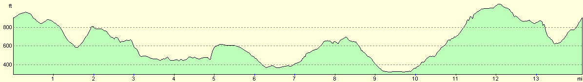
For more information on profiles, ascents and descents, see this page
Disclaimer
Please note that I take no responsibility for anything that may happen when following these directions. If you intend to follow this route, then please use the relevant maps and check the route out before you go out. As always when walking, use common sense and you should be fine.
If you find any information on any of these routes that is inaccurate, or you wish to add anything, then please email me.
All images on this site are © of the author. Any reproduction, retransmissions, or republication of all or part of any document found on this site is expressly prohibited, unless the author has explicitly granted its prior written consent to so reproduce, retransmit, or republish the material. All other rights reserved.
Although this site includes links providing convenient direct access to other Internet sites, I do not endorse, approve, certify or make warranties or representations as to the accuracy of the information on these sites.
And finally, enjoy your walking!
Nearby walks
| # | Title | Walk length (miles) |
|---|---|---|
| 11 | Stanton Moor | 2.9 |
| 12 | Darley Dale, Stanton Moor and Rowsley | 8.7 |
| 14 | Friden, Long Dale and Gratton Dale | 7.8 |
|
|

|