Walk #575: Doveridge to Ashbourne via the Weaver Hills
 |
 |
|
General Data
| Date Walked | 27/11/2003 |
| County | Derbyshire, Staffordshire |
| Start Location | Doveridge |
| End Location | Ashbourne bus station |
| Start time | 08.10 |
| End time | 14.41 |
| Distance | 16.9 miles |
| Description | This was quite a nice walk to the top of the Weaver Hill, followed by a long descent down into the centre of Ashbourne. |
| Pack | Today I carried my 30-litre Karrimor HotRock rucksack, which was filled with my waterproof leggings, water bottle and a couple of spare shirts, together with the usual assortment of odds and ends. |
| Condition | I had not done a walk for five weeks, and it certainly felt like it today. I had trouble with my feet, on which I developed hot-spots (the forerunner of blisters), and my left leg and hips ached a great deal towards the end of the walk. I cannot have been in too bad a state, however, as when I got back to Uttoxeter I decided to walk the two miles home instead of waiting for a bus. |
| Weather | This morning started off very cold (it had been -5.5 degrees in Uttoxeter last night), but as the sun slowly rose it warmed up to around thirteen degrees. The top of the Weaver Hills was cold due to the wind, but this was not noticeable anywhere else. All in all it was a superb day for a stroll. |
| OS map | Landranger number 128 (Derby & Burton upon Trent) |
 |
 |
|
 |
 |
|
Map of the walk
Maps courtesy of Google Maps. Route for indicative purposes only, and may have been plotted after the walk. Please let me have comments on what you think of this new format. For a detailed table of timings for this walk, please see the table file.
 |
Notes
It had been my intention today to walk from my parent's house in Doveridge to the Weaver Hills and back again, a walk that I had done six or seven years before on a hot summer's Saturday. Doveridge is not an ideal place to base myself for walks, as the River Dove blocks any walks southwards and I have to walk towards Uttoxeter to cross the river. Unfortunately doing walks anywhere else was out of the question, as we sold Mervan last week and I am yet to get my Rover car back on the road. This is a shame as I am dying to do some walks in the Peak District, such a tantalisingly short distance away, but this will have to wait until my car is back on the road on Monday.
I had been planning to go for a camping trip for two or three days, walking from Doveridge to a campsite at Hartington in the Peak District and then walking back again. This would allow me to explore that area of the Peak District in more details, and perhaps do the entire Tissington Trail in one day. After some thought, however, I decided against this as I thought that it was too much after five weeks without dong a walk, and that it would be best if I did a few warm-up walks before attempting a backpacking trip. Another factor in this decision is that the weekend is going to be very wet, and so I would only get a two-day trip, and no time to go exploring the local area without getting soaked.
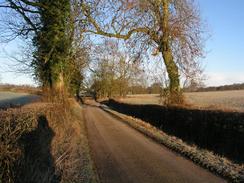
Once I finally set off this morning (after an obligatory cup of coffee) it was a cold morning with a heavy frost covering everything in sight. The cold enlivened the senses, and I revelled in the clear, sunny skies. I nipped into the post office in the village to stock up on a few nibbles for the walk, and then set off towards the bridge over the A50(T). The noise of the road (it has a concrete rather than a tarmac surface) told me that I was near it before I saw it, and I then started the descent to the Doveridge Sporting Club at Eaton Hall Farm, where I joined the Staffordshire Way. This is a large clay-pigeon shooting club, and I could see the ranges on the valley floor below me.
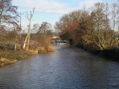
I passed the boarded-up and decaying farm at Sedsall, a favourite place of mine and a building that I would love to buy and restore, before crossing the playing fields of Abbotsholme School and reaching the attractive stone bridge over the River Dove. This heralded my entry into Rocester, and after crossing the bridge I passed the imposing mill, built by Richard Arkwright (inventor of the spinning-frame) in 1781 to 1782, before reaching the centre of the village. Rocester is nowadays best known as the home of JCB, the massive construction plant company, but it has a long history - there was a Roman settlement here. I used to go to school at Denstone College above JCB, and I remember that Rocester was dominated by a series of low and frankly ugly flat-roofed flats in the centre of the village. Fortunately these have been demolished and replaced with some far better looking flats that have increased the ambience of the village tremendously.
The JCB factory in Rocester is extremely large, but is not a bad-looking factory - it is painted green and has some extremely nice landscaped grounds around it. I was surprised to see the large fountain in one of the lakes was on, shooting water high up into the air, and to my left I could see the JCB monster, a sculpture made up out of parts of JCB diggers. Above the factory I could see the grounds of my old school, and I resisted the temptation to go up the hill to have a look around. I followed the Staffordshire Way until I reached the B5032 road at Quixhill, where two low-flying Chinook helicopters overflew me, the sound of their two rotors being very distinctive. At Quixhill I left the Staffordshire Way and started the walk northwards to the Weaver Hills. Initially this took me through the JCB testing grounds, and these were a hive of activity. At one place I came across a series of test tracks with sculptured concrete floors, designed to give vehicles' suspensions a hard ride. These had names such as 'random curve', 'regular curve' and 'wave motions', and were shaped in exactly the way you can imagine from the names. There was also a Fastrack (a sort of fast tractor) with a large cabin at the back, called a 'data acquisition unit', which looked quite fascinating. All in all it was a great area to walk through for someone who (like me) enjoys big engineering - I only wish I could get to drive a JCB around the test tracks!
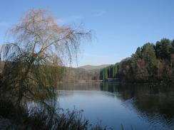
I passed an extremely attractive lake (still on the JCB test ground) before reaching the grounds of Wooton Park. I was surprised to see a footpath sign pointed straight through a stone wall, and only when I got closer did I see that there was a tiny gap that I only just managed to squeeze through. This led me onto the grounds of Wooton Park, and after I passed near to the large hall I reached the deer park, where there were some fairly tame deer everywhere. I could not find the footpath across the grounds, so instead of cutting across the grass to try and find it I just walked down the tarmac track through the grounds. This was a very pleasant walk and deer approached me on several occasions, one passing only a couple of yards in front of me. I was sad when I left the park and made my way on to the village of Wooton, which marks the start of the climb up to the top of the Waver Hills.
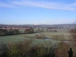
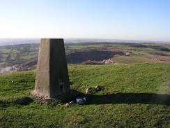
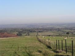
By this time my left leg was starting to ache, and the stiff climb up to the trig point at the summit was no exception. Once I reached the top I took my pack off and admired the expansive views from the summit; the views to the south in particular is superb, and I could see all the way to Cannock Chase, with several of the Trent Valley power stations visible. The views to the north into the Peak District were less good, and those to the west were fairly grotty, as the western end of the hills have been chiselled out by a couple of quarries - a tremendous shame. I sat down for a while but I was in a very exposed location, and the wind proved to be annoyingly chilly. I really wanted to spend some more time and soak in the atmosphere, but after fifteen minutes I decided to walk on and warm myself up. The second half of the walk towards Ashbourne proved to be very different to the first, as instead of walking along the floodplain of the River Dove I was in the low foothills of the Peak District, and this meant a much hillier walk.
As my legs were hurting me much more than I had expected, I decided not to walk back the way that I had come and to walk into the nearby town of Ashbourne instead. I soon found myself in the little village of Stanton, and from there I walked along a combination of roads and footpaths into Mayfield. A descent down a steep lane took me to the old 'Hanging Bridge' over the River Dove, which carries the A52(T) over the river. I soon found myself in Ashbourne, only to find that I had missed a bus by a few minutes and I had to wait for two and a half hours. I nipped into the Coach and Horses pub near the bus station, and I managed to make two pints last two hours whilst I waited. Unfortunately by the time the bus got into Uttoxeter I had an hour to wait for the next bus home to Doveridge, and instead of waiting in the cold I walked back the two miles home, meaning that in total I walked about nineteen miles today.
Directions
From the Post Office in Doveridge head north out of the village along Sand Lane, passing the village hall before reaching the roundabout with the old main road. turn left along the old main road (called Derby Road) until the Cavendish Arms is met on the left. When the road curves to the left past the pub continue straight on along another road for a few yards, and then turn to the right along Upwoods Road. This road heads northwards, crossing over the A50(T) on a bridge. When the road forks immediately over the bridge take the left fork down the hillside towards Eaton Hall Farm. At the top of the hill the public road ends and a public footpath continues on down to the farm and gun club. Pass through the farm and follow the Staffordshire Way along a track that reaches a T-junction with another track. Turn right along this track for a hundred yards towards Eaton Dovedale Farm. Just before the farm is reached turn left down another track that leads northeastwards towards the abandoned farm at Sedsall. When the track heads to the right uphill turn to the left, following the Staffordshire Way as it skirts to the left of the boarded-up farmhouse before skirting the base of the hillside northeastwards.
Continue on along the Staffordshire Way as it heads northwards near to the River Dove; at a loop in the river the way cuts straight across a school playing field near Abbotsholme School before rejoining the riverbank and following it northwards to Rocester Bridge. Climb up the steps to the road and then turn left to cross the bridge over the River Dove, and continue on past Arkwrights mill into the centre of Rocester. In Rocester turn right up a road that heads northwards for about half a kilometre until it ends at a T-junction with the B5030 road. Turn right along the B5030 and then almost immediately turn left towards the B5031 road. Do not follow the B5031, but take the Staffordshire Way as it heads northwards from the junction of the B5030 and B5031 roads. The path initially climbs up alight hill, with some good view over the Churnet Valley, before descending through an area of patchy woodland back onto the valley floor. The path eventually reaches the B5032 road at Quixhill, and here the route leaves the Staffordshire Way.
Turn right up the B5032 for a few hundred metres, passing an imposing entrance gateway into Alton Park on the left, before taking a minor road that leads off to the left. Follow this road as it heads northwestwards, and when it curves sharply to the right continue straight on down a track that leads into the JCB testing grounds. After a short distance when the track curves to the right uphill continue straight on along a footpath for a hundred yards, until it crosses a little stream and reaches another track. Turn right and follow this track as it crosses the stream on a ford (there is a little footbridge on the left), and on the other side of the bridge follow the footpath as it heads up the hillside to the right. At the top of the hillside the path meets another track; here turn left along it and follow it towards a little car park. Follow the footpath as it skirts to the left of the car park before turning to the right and ending at yet another track. Turn left and follow this track until it ends at a T-junction at the bottom of a hill.
At the junction turn right and follow the track until it reaches the southern end of a beautiful lake. Turn to the left and follow the track along the western bank of the lake; just after a little island a footpath leads off to the right alongside the shoreline as the track heads away to the left; take this footpath and follow it past a boathouse and out onto the track once more beside a bridge. Cross the bridge and immediately on the other side turn left along another footpath that leads out onto a private road. Turn right up this road for a short distance, before taking a footpath that leads off to the left, through a very narrow gap in a stone wall and into Wooton Park. Follow the footpath northeastwards across the park for a few hundred yards, with Wooton Lodge down the hill to the left, and when some buildings are reached join a track and turn left down it. The actual footpath leads across the park, but I found it hard to find. Follow the track northeastwards until the gatehouse is reached at the northeastern corner of the park.
Leave the park through the gate, and then immediately turn to the left down a footpath that heads northwards; initially it follows a little sunken channel before turning to the right slightly. When the footpath ends at a road turn to the left and descend down into the village of Wooton. Follow the road as it curves to the left, and then take a track that leads off to the right. The track climbs uphill past the Wooton cricket club, and then a footpath leads off through a stile to the left. Follow this footpath as it heads northwestwards, aiming for a gap between two hills. Once in the saddle between the two hills continue on until a stile is reached, and then turn to the left to climb up the short distance to the trig point on the western hill. From the trig point descend back down to the saddle and then head north until a fence line is reached. Turn right and follow a footpath that runs southeastwards alongside the fence until a road is met. Turn right down this road for a short distance and then turn to the left down a footpath that descends down the hill to a stream.
Cross the stream using a little plank footbridge, and then follow the footpath as it slowly heads uphill to the east. At a house it descends steeply into a little valley before climbing uphill to the northeast before reaching a road in Stanton. Turn right and follow this road as it heads eastwards through Stanton; when this meets another road continue eastwards as the road descends very steeply down into a valley. At the bottom of the hill turn to the right along another footpath that crosses a stream on a plank bridge and then climb uphill to the east. Near the top of the hill the footpath crosses a track; this track carries the Limestone Way. Continue on along the footpath southeastwards as it heads slightly downhill and reaches a farm access track. Turn left along this track and follow it eastwards; fairly soon it becomes a public road and reaches a crossroads to the north of Mayfield. Turn to the right and pass the little chapel in the village, and then turn left down a minor road that leads steeply downhill before ending at a T-junction with the B5032 road.
Turn left along the B5032 for a few yards until it ends at a T-junction with the A52(T), and then turn to the right to cross the Hanging Bridge over the River Dove. Head eastwards along the A52(T0 for about a kilometre until a roundabout is reached. At the roundabout turn left (essentially continuing straight on) and follow the road northeastwards towards the centre of Ashbourne; there is a pavement the entire way between Hanging Bridge and Ashbourne so the walk is fairly safe. Pass the church in Ashbourne and then take the second main road to the right, which passes the Coach and Horses pub before crossing a stream. Once over the stream turn to the right along a one-way street; the bus station is a short distance down this street on the left-hand side.
Distances
| From | To | Distance (m) | Ascent (ft) | Descent (ft) |
|---|---|---|---|---|
| Doveridge | Rocester | 4.3 | 236 | 233 |
| Rocester | Weaver Hills trig point | 6.2 | 1319 | 397 |
| Weaver Hills trig point | Ashbourne bus station | 6.4 | 453 | 1270 |
This makes a total distance of 16.9 miles, with 2008 feet of ascent and 1900 feet of descent.
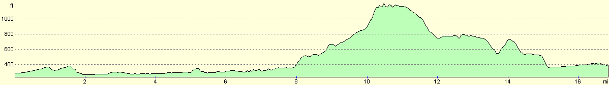
For more information on profiles, ascents and descents, see this page
Transport
There are four busses a day from Ashbourne to the bus station in Uttoxeter (with less services on Sundays), and then there are hourly busses from Uttoxeter to Doveridge.
Disclaimer
Please note that I take no responsibility for anything that may happen when following these directions. If you intend to follow this route, then please use the relevant maps and check the route out before you go out. As always when walking, use common sense and you should be fine.
If you find any information on any of these routes that is inaccurate, or you wish to add anything, then please email me.
All images on this site are © of the author. Any reproduction, retransmissions, or republication of all or part of any document found on this site is expressly prohibited, unless the author has explicitly granted its prior written consent to so reproduce, retransmit, or republish the material. All other rights reserved.
Although this site includes links providing convenient direct access to other Internet sites, I do not endorse, approve, certify or make warranties or representations as to the accuracy of the information on these sites.
And finally, enjoy your walking!
Nearby walks
| # | Title | Walk length (miles) |
|---|---|---|
| 24 | The Weaver Hills | 6.0 |
| 68 | Willington to Doveridge | 12.6 |
| 69 | Doveridge to Thorpe | 14.9 |
|
|

|