Walk #297: Norman's Bay to Beachy Head via Eastbourne
 |
 |
|
General Data
| Date Walked | 15/12/2002 |
| County | East Sussex |
| Start Location | Norman's Bay |
| End Location | Beachy Head |
| Start time | 08.28 |
| End time | 12.25 |
| Distance | 10.8 miles |
| Description | This was a short walk into Eastbourne that was followed by a steep climb up onto the top of Beachy Head. |
| Pack | Today I carried my 30-litre Karrimor HotRock rucksack, which was filled with my packed lunch, waterproof leggings, water bottle and a couple of spare shirts, together with the usual assortment of odds and ends. |
| Condition | I feel absolutely fine after this walk, and have no problems of any kind to report. Yet again my ankle did not give me nay trouble, which I am very thankful for. |
| Weather | The weather today was frankly dreadful, with rain falling all day at various intensities ranging from outright downpour to light drizzle. Fortunately the wind was coming from behind rather than in front, so despite the rain I did not really get that wet. The wind was also fairly light and it was quite mild, so I did not get chilled very much. |
| OS map | Landranger number 199 (Eastbourne & Hastings, Battle & Heathfield) |
 |
 |
|
 |
 |
|
Map of the walk
Maps courtesy of Google Maps. Route for indicative purposes only, and may have been plotted after the walk. Please let me have comments on what you think of this new format. For a detailed table of timings for this walk, please see the table file.
Notes
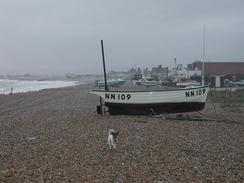
I found the first part of this walk along the shingle beach to be fairly hard on my feet, and I have now decided that shingle is definitely the worst surface to walk along. It is just so uneven, and I find that if the shingle is shallow (especially if there is tarmac beneath it) then it is also quite slippery, as if I was walking across marbles. I have had a few days of shingle now, and I am actually looking forward to seeing some proper sandy beaches or some high, magnificent cliffs.
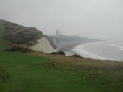
Unfortunately the weather really spoilt today's walk. I should have been able to have some fairly expansive views from the top of Beachy Head, but these were not available due to the mist, cloud and rain that proved to be ever present. To make matters worse many of the photographs that I took got spoilt by raindrops getting on the lens, so I am not happy with many of the photographs that I have used on the website.
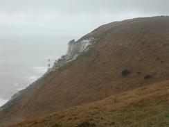
By the time that I reached Beachy Head I was fairly drenched, although fortunately not to the skin. Sam was waiting for me at the pub at the top, and I decided not to walk on to Birling Gap, which had been an option that I had been considering. I therefore shrugged my soaked pack off into the van, and we retired to the pub where I had a pint. The pub also has a visitors centre attached to it, and we spent an enjoyable ten minutes looking around it. I was hoping that it would have more information on the lighthouse that was moved back from the edge of the cliff last year, but there was nothing about that feat of engineering that I could see. There was information on how the lighthouse at the bottom of the cliffs was constructed, and I really wish that I could have worked on the project - it was truly engineering on a massive scale. What particularly surprised me was the fact that a bucket and cable system was used to get materials down from the cliff top to the lighthouse at the base of the cliffs; it is an obvious way to do it in retrospect, but it honestly had not occurred to me that they would do that.
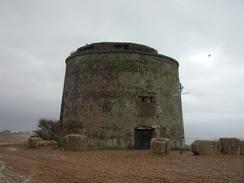
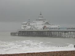
Eastbourne was a lovely little town with Georgian and Victorian seafront buildings. The pier is a beautiful example of that type of structure, with a nice glass pavilion and only the very entrance being commercialised, and even then not in a totally outrageous way. It was a shame that I was in the town in the rain, as I am sure that I could have taken many better photographs of it if it had not been so wet. I was curious about the so-called Wish Tower - this is basically a normal Martello Tower, and I am intrigued about how it may have got such a strange local moniker.
One of my reasons for cutting the walk short is so that I stand a better chance of getting some nice photographs - preferably with views - from Beachy Head and the Seven Sisters. The cliffs at Beachy Head are 354 feet high, and the lighthouse at the base is only 142 feet high and has a power of 274,000 candlepower. I really do hope that the weather is better tomorrow and that I can take some nice photographs of the lighthouse and the hills to the north - the South Downs, which I hope to walk one day.
Directions
This walk starts at the Star Inn in Norman's Bay. Leave the car park and turn right to head southwestwards along the road. After a few hundred yards turn left down a private road that heads south to cross the railway line at the station. When the road meets the beach it turns to the right to parallel the beach as it continues on for a mile towards Beachlands. By a caravan park it becomes a public road.
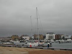
In Beachlands turn left to join the shingle beach, and follow this as it heads southwestwards past Pevensey Bay for over two miles until the beach ends at Pevensey Harbour, where new apartment blocks are being built immediately inland. Turn right and walk past the harbour and then turn left down a muddy road that leads to a swing bridge over gap between the two halves of the marina.
On the other side of the bridge continue straight on past a little retail park until a T-junction is reached. At the junction turn left and head southeastwards until the coast is met once more near Langney Point. Turn right and follow a combined cycle path and footpath that heads southwestwards, passing the leisure centre, a lifeboat station and an old redoubt fort (which is now a museum) before reaching the pier in the centre of Eastbourne.
Continue southwestards along the promenade from the pier climbing up to the Wish Tower (an old Martello Tower) and onwards, following signs pointing to Beachy Head. Eventually the path climbs up to reach the B2103 main road, which it follows for a short distance uphill until it turns sharply to the right. At this bend three footpaths continue straight on; two of these are the Wealdway and the South Downs Way. Take a footpath, signposted Cow Gap, which leads off uphill to the left. After about a hundred yards this meets the edge of the cliff and then turns right to climb uphill.
The path reaches the top of a little hill before descending into a valley and rising up once more to Cow Gap. At Cow Gap it turns to the right and climbs steeply uphill for a short distance until it meets a tarmac path. Turn left and follow this path as it turns around the hillside and reaches the Beachy Head pub, where this walk ends.
Distances
| From | To | Distance (m) | Ascent (ft) | Descent (ft) |
|---|---|---|---|---|
| Norman's Bay | Eastbourne | 7.7 | 59 | 56 |
| Eastbourne | Beachy Head | 3.1 | 778 | 276 |
This makes a total distance of 10.8 miles, with 837 feet of ascent and 332 feet of descent.
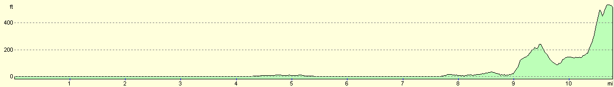
For more information on profiles, ascents and descents, see this page
Accommodation
We stayed at the excellent Sheepcote Valley Caravan Club Site, East Brighton park, Brighton, BN2 5TS. This was a lovely site, with clean toilets and piping hot showers, which was just what I wanted after two days without having a shower. They can be contacted by telephone on 01273 626546. The only problem with this site is that it was quite a drive from where we finished the walk; we shall probably stay here tomorrow night as I shall finish tomorrows walk very near to the site.
Disclaimer
Please note that I take no responsibility for anything that may happen when following these directions. If you intend to follow this route, then please use the relevant maps and check the route out before you go out. As always when walking, use common sense and you should be fine.
If you find any information on any of these routes that is inaccurate, or you wish to add anything, then please email me.
All images on this site are © of the author. Any reproduction, retransmissions, or republication of all or part of any document found on this site is expressly prohibited, unless the author has explicitly granted its prior written consent to so reproduce, retransmit, or republish the material. All other rights reserved.
Although this site includes links providing convenient direct access to other Internet sites, I do not endorse, approve, certify or make warranties or representations as to the accuracy of the information on these sites.
And finally, enjoy your walking!
This walk was mentioned in the following routes:
| My walk around the coastline of Britain |
Nearby walks
| # | Title | Walk length (miles) |
|---|---|---|
| 296 | Winchelsea Beach to Normans Bay | 17.6 |
| 298 | Beachy Head to Peacehaven | 16.7 |
|
|

|