Walk #735: Thames Path: Stonehouse to Ashton Keynes
 |
 |
|
General Data
| Date Walked | 26/08/2006 |
| County | Gloucestershire, Wiltshire |
| Start Location | Stonehouse station |
| End Location | Ashton Keynes |
| Start time | 10.00 |
| End time | 18.51 |
| Distance | 21.3 miles |
| Description | This was a very pleasant walk following the Stroudwater Navigation and Thames & Severn Canal eastwards to the source of the Thames, after which the Thames Path took me onwards. |
| Pack | Today I carried my 80-litre Macpac Glissade rucksack, containing a North Face Blue Kazoo sleeping bag, my Jack Wolfskin Gossamer tent, clothes, waterproofs and other camping items, excluding cooking gear. |
| Condition | I am fairly tired after this walk, but have no problems worth mentioning. |
| Weather | The day was a mixture of sunshine and showers, the former fortunately being more prevalent than the latter. It was quite a warm day when the sun was out, and there was not much of a wind to cool me down. |
| OS map | Landranger number 12 (Thurso & Wick, John O'Groats) and Landranger number 163 (Cheltenham & Cirencester, Stow-on-the-Wold) |
 |
 |
|
 |
 |
|
Map of the walk
Maps courtesy of Google Maps. Route for indicative purposes only, and may have been plotted after the walk. Please let me have comments on what you think of this new format. For a detailed table of timings for this walk, please see the table file.
 |
 |
|
 |
 |
|
Notes
I got up early this morning and had a bleary-eyed journey from Cambridge to Stonehouse, deep in the Cotswold hills. One of my targets for this year was to walk the Thames Path, and whilst this officially starts near Kemble I decided to connect it up with the Cotswold Way, which I walked a couple of years before. The train pulled into Stonehouse about fifteen minutes late, and after doing some stretches and waiting for the train to go I headed off down the road by my target time of ten.
My pack felt heavy on my shoulders - it was the first time that I had used this new pack, and although it was comfortable I could certainly feel the weight of all of the contents. The walk towards the canal was fairly unremarkable aside from the Cotswold stone used in many of the buildings, a stone that I have always like the look of. I had seen many of these buildings from the train as it had passed through Stroud, and it was nice to see some new buildings also being constructed from the stone.
I soon joined the Cotswold Way for a few yards near a white footbridge over the road, and it was with some trepidation that I remembered that when I had been walking the Cotswold Way I had talked to my ex, Sam, on my mobile from Kings Stanley, a short distance away. I often got melancholic at the beginning of a long walk, and half of me realised that thinking about my ex was a silly thing to be doing at the start of this walk. I therefore put the thoughts to the back of my mind as I reached a bridge that led over the Stroudwater Canal, and as I was already overheating I stopped temporarily to take my coat off. The clouds overhead and the dismal drizzle when I had left Cambridge led me to think that I would soon have to put it back on, however.
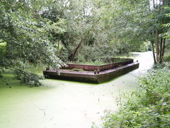
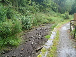
The initial stretch of the canal was green with algae, a sign that although this stretch is in water it is not yet navigable. A sign beside the towpath stated that the canal towpath was soon going to be closed in sections to allow the canal to be rebuilt, part of the scheme by the Cotswold Canals Trust scheme to reopen the entire canal between the Severn and Thames. The first part of this is a �25 million pound scheme to reopen the six miles between Stonehouse and Brimscombe Port, and as I walked along I could see how hard it will be to reopen in places. The walk along the canal was very enjoyable, with a narrow unsurfaced towpath being surrounded by greenery on both sides, including nettles overgrowing the path.
Fairly soon I came across a large lock, not without gates but with brickwork that seemed to be in good condition. Above this the canal was totally overgrown, a large mass of brambles covering the canal bed, and shortly beyond this it was infilled to an extent that it was impossible to tell that there had ever been a canal there. After rising up to go over an old bridge there was a short stretch that was in water beside a new housing development, giving an impression of what the rebuilt canal will look like. This short stretch was separated from the next section by a small causeway built across the canal to allow plant access across for a new development. Beyond the canal was still in water but was narrow, silted up and overgrown, and two locks were without gates and had weirs allowing water to cascade over.
This led me to realise that for the first half of today's walk I was heading uphill, and all of the water falling around me was heading west to the Severn, whilst later on it would all be heading eastwards towards the Thames. It is strange to think that the watershed is this far east, but this is similar to the Severn, where the source is very near to the west coast of Wales. When the towpath reached a double roundabout in Stroud I had to join the A419 for a period as it headed eastwards, passing under a railway bridge before reaching another roundabout. It was hardly a salubrious part of town, with builder's merchants to my left and traffic roaring by me as I followed the wide pavement. I could see the canal a short distance away, but it was not obvious how to get onto the towpath from the road.
It then started to spit with light drizzle, which soon became a heavy downfall as I joined the canal towpath once again. I tried to walk through it as I did not want to put my coat on due toe the warmth, but the rain got too heavy and I sheltered under a tree as I quickly put it on. The rain was falling like drain rods, and perversely I could see patches of blue sky, a sign that the downpour was not going to last too long. This proved to be the case, and after ten minutes the rain had stopped, and the weather became a combination of sunshine and cloud. Because of the cloud I decided not to take my coat off, and walked on getting increasingly warm.
The towpath soon reached Brimscombe Mill, where it ended at a road. The canal here has been filled in, and I decided to keep on the level rater than climbing uphill. On my left there was a beautiful mill building made out of Cotswold stone that looked to be recently restored, and off to my left were a series of disused industrial buildings. There was absolutely no trace of the canal on the ground, and when I saw a man ahead of me I asked him where I should go to rejoin the towpath. It turned out that he was walking the same way, and we chatted as we walked. Apparently at one time Brimscombe Port was the largest inland port in Britain, and there are plans to reopen the canal as fare as here in the next couple of years. As I looked around the flat and dry area it was hard to believe that this was once a port, and I can imagine that the area can only be improved by the canal being reopened. All of the modern industrial buildings have been bought by British Waterways, and will be pulled down for the development.
The man had been in the army and as we strolled along we chatted about how walking boots have changed over the years. Once the canal towpath had been regained he walked off along another path, and I headed on eastwards towards Brownshill and Chalford. The canal crossed the A419 once more, and here the canal was essentially drained, the muddy bottom clearly accessible. The stroll took me on to the Red Lion pub, and as I was seven and a half miles into the walk I decided to stop in for a rest. The Grand Prix Qualifying was on and so I decided to stay longer to watch it. I had a lovely pint of Moles Bitter and another of orange and lemonade whilst I waited for my food to come. I had ordered a basket of scampi and chips; I was surprised to find that a basket was three pounds cheaper than a plate of the same meal. The food was lovely and as I ate I chatted to the barman about Formula One and other important matters.
Before I left the pub I packed my coat away into my rucksack once again, and within a couple of minutes of setting off it started to drizzle once again. Instead of stopping to put my coat on I walked through it, and within a few minutes it had stopped once more. The towpath joined the Wysis Way, a trail that connects Offa's Dyke Path with the Thames Path via the Severn at Gloucester, and the canal was soon climbing up along a series of abandoned locks through the superb scenery of the Golden Valley. The towpath entered some woodland Trust woodland, and after it exited this it reached the Daneway Inn, a whitewashed building built beside the canal. There was a marquee set up in the car park and music was blasting across the car park, signs of the music festival that was being held. It seemed as though people were enjoying themselves, and I withstood the temptation to go in for a drink and strolled on along the towpath.
A little further on I reached the portal of Sapperton Tunnel, one of the longest canal tunnels in the country. It is currently closed due to a couple of roof and side falls, but there are plans to reopen it with the rest of the canal. The portal was in a magnificent Gothic style, and I explored around a little before climbing up along the path, which crossed the top of the portal, passing immediately behind the castlements. The path then exited the trees, and started climbing steeply uphill. There were some pleasant views from the climb, and before I knew it I reached the village of Sapperton. Another footpath took me up to the top of the village, and what followed was along road walk along what was a fairly quiet road, the occasional cars invariably roaring past me at speed.
It was therefore a relief when my route left the road to cross a field on a footpath towards the A419, and on the other side towards some woodland. By this stage I was feeling quite hot, and the shelter of the trees proved to be very welcome as the footpath followed a couple of tracks as they would through the woods. It took me longer than I expected to walk through the woods, and after passing under a railway bridge the track led on to emerge suddenly at the top of the other portal of the canal, near to the Tunnel Inn. This seemed to be quite busy and there was a little impromptu game of cricket going on in the car park, a tennis ball being used to ensure that the surrounding cars would not be damaged.
I followed a path that led down to the canal, which at this point is in a fairly deep cutting. The canal was dewatered and the concrete lining of the canal used at this point to reduce leakage was easily visible. This stretch of canal can actually hold water well, and the canal society run occasional barge trips a short distance into the tunnel - although it will have to be refilled before it can be used again. I strolled down to the bottom of the canal and tried to look into the tunnel with little success, before climbing up once again and continuing on along the towpath, which ran on a ledge between the cutting side and the canal.
A little further on the towpath passed a curious round stone building, looking quite magnificent and almost as if it was a restored ruin. The towpath then turned and passed under a railway bridge, and the path was increasingly overgrown and dark as the path headed onwards, and on occasion I had to fight overhanging branches. Fairly soon another bridge over the canal was reached, with the overhanging trees making it seem gloomy and depressing. On the other side of the bridge several loads of rubbish had been dumped into the drained canal, the burst black plastic bags adding to the general gloom.
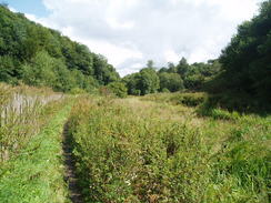
I continued on around the bend beside the bridge and headed southwards along the towpath for a few yards until it was blocked by trees. The path was impassable, so I dropped down the steep side of the bank into the canal bed and started following this. It was easier going through the trees that grew here, and I made relatively good time as I started to realised that, although there was a faint path through the trees, it was not frequently walked and I was probably not on the footpath. Looking at the map I could see the red dotted line denoting a footpath, and it did seem to be on the field side of the canal rather than along the canal. I did not mind the diversion and I continued along the bed until it was blocked by some barbed wire and some garden refuse that had been dumped.
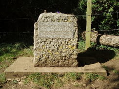
As the way along the canal bed was blocked I climbed up the steep slope onto the canal towpath, and started forcing my way through the trees that grew along it. I knew that I had to make my way to the stone that marks the start of the Thames Path, and in the field below me I could see the top of a couple of heads behind a wall. I shouted down to them to ask where the stone was, and the man stood up and with a smile told me that they were sitting by it! The vegetation was too thick for me to push through, so I continued on for another few yards until it became clearer as I angled down the bank towards a barbed wire fence. This was too loose to climb over, so instead I took my rucksack off and with difficulty slid it down the bank, the sack rolling over a couple of times as it did so. I then followed it, and with joy strolled back to the start of the path.
I soon joined the couple, who were sitting on a patch of grass beside the stone. It was a pleasant spot to stop, and I sat down near them, taking my rucksack off for the second time in five minutes before starting to chat. They had just completed the stretch of the Path from Oxford meaning that the lady had completed the Thames Path. She seemed absolutely ecstatic that the walk had been completed, and I felt similar in the fact that I was about to begin the trail. Eventually they left and I was left sitting there as a steady stream of people came along to visit the stone.
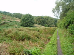
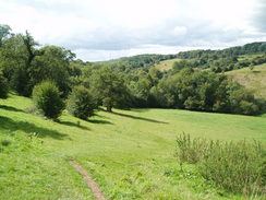
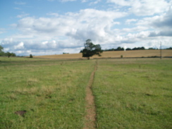
Eventually I felt the need to leave, and after asking someone to take my photograph I shouldered my rucksack and started off southeastwards. Initially the path followed a footpath across fields towards the A433, and there was no sign of any water or stream anywhere; the Thames rises in a spring, and in summer the source is generally very dry. On the other side of the A433 the path continued across more fields towards the A429, and it was just before this was reached that the first sign of the Thames was visible, in the form of a dry, wide channel leading up to a bridge under the road. I descended down to the grassy bed (a sign that it is rarely in water) and clambered up the other side, thus being able to say that I have walked across the Thames!
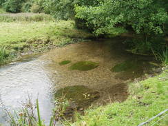
On the other side of the road the path headed on, bypassing away from Kemble before reaching a road, which was followed into an attractive village called Ewen. After passing through the village the path continued on, and for the first time there was a little stream running in the bed of the river. After passing a gauging station the flow looking barely enough to register the path headed south, crossing fields with the stream to my right. By this stage I was getting tired, and although the going was easy the earlier walking had fatigued me more than I had realised. The path soon reached the Neigh Bridge Country Park, and fishermen still lined the side of the bank despite the fact that it was starting to get late.
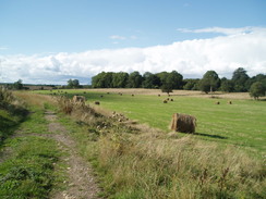
A short stretch of road followed, before the trail headed down a track towards Lower Mill, past a series of lakes. There was a new and what looked to be fairly exclusive housing development on the right, the gates leading into the houses making me think who they needed protection from. I struggled on, crossing the border into Wiltshire before reaching the small village of Ashton Keynes. Although I was tired there were still a couple of miles left in my legs, and I was planning to camp somewhere on the path to the southeast of the village, which would reduce what promised to be a long day tomorrow by a useful amount.
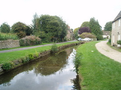
The village was pretty, and I enjoyed strolling through it, passing one of several crosses to a road junction. Here a man was opening a gate from a house, and I stopped to ask him if he knew of anywhere that I could camp. He seemed to study me for a moment, before offering me a place in the field beside his house. I accepted the kind offer in an instance, as it meant that I could visit the pub later on, and he took me past the house to a large and neatly-kept field behind. It did not take me long to get my tent erected, and as the sun started sinking ever lower I lay down on a mat and read a book. The lady of the house soon arrived, and after initial alarm at seeing my tent we had a pleasant chat.
After a little rest I felt fairly well recovered, and so I got up off the mat and headed down the road towards the pub. This was fairly packed with locals, and I found a clear space whilst I read and waited for my meal to arrive. This turned out to be filling, and I washed it down with a second pint before eventually heading back to me tent, feeling very pleased with finally having started the Thames Path.
 |
 |
|
Directions
|
This walk starts off at Stonehouse station, deep in the Cotswold contryside. Leave the station and head down the approach road for about fifty yards until the B4008 Bath Road is reached opposite a church. One this is reached turn left and follow the B4008 southeastwards for a few hundred yards until a junction with the A419 is reached. Turn right to head south down this for about twenty yards until a bridge over a canal is met; cross the bridge, and once on the other side turn left to start following the canal towpath eastwards. The walk then simply continues along the course of the canal as it climbs eastwards from Stonehouse towards Stroud; in places the towpath is unwalkable due to obstructions (more of which should be removed as the canal slowly gets reopened). From Stroud the canal slowly curves to the right to start heading in a more southeasterly course, and the towpath is easy to walk until it finally gets obliterated by a road at the entrance to Brimscombe Port. Join the road and continue straight on along the level; pass a newly-restored mill on the left and then kink left and almost immediately right, to pass a car park on the left and continue on in an easterly direction. The road heads on for a short distance until the canal towpath is rejoined once again, with the canal being in water, but unnavigable. It heads eastwards past Brownshill and Chalford, before eventually getting cut off by the A419 in Chalford. Cross the A419 and continue along the canal on the other side; the canal when I walked it was drained and the clay bed was clearly visible. Soon the path enters the Golden Valley, after which a long climb to the summit begins as the canal passes a series of ruined locks. Eventually the path reaches the last lock by the Daneway Inn, where the canal turns sharply to the right to continue eastwards to the Gothic portal of Sapperton Tunnel. At the portal the path climbs up to the top of the portal, passing directly beside it before entering a field. It climbs diagonally eastwards up this steep field, soon leaving it as the gradient slackens and passes between some cottages before ending at a lane. Turn right along the lane for a few yards until it ends at a road; turn right down the road and them almost immediately turn left to take a footpath that heads uphill southwards before meeting another road by the village green. Join this road and follow it as it heads southeastwards; after a few hundred metres a crossroads is reached. Continue straight on along this as it heads southeastwards for about a kilometre and it starts to drop downhill. Just before a right-hand bend a footpath leads off to the right; take this footpath as it heads south across a field to the A419 road. Carefully cross the A419, and on the other side continue on along a footpath that heads south towards Hailey Woods. A track leads through the woods in a southeasterly direction, before curving to take a more southerly direction, passing under a railway bridge and then turning slightly to the left to end above the southeastern portal of the tunnel. Walk over the tunnel mouth, and when the Tunnel Inn is reached turn left to descend back down to the canal towpath. Follow this as it heads south through a cutting to a bridge; after this the canal is dewatered as it curves to the left to head in a more easterly direction. The towpath becomes increasingly rough as it heads eastwards for a kilometre, until another bridge over the canal is reached in a dingy area overhung with trees. Here the canal turns to the right to head southwards, but leave the canal and turn right onto the bridge and onto a lane. When this enters a field follow the edge of the field south along a footpath to the stone that marks the source of the Thames, and the start of the Thames Path. |
The walk is also covered in detail in the Thames Path National Trail Guide, by David Sharp, ISBN 1-84513-062-6 published by Aurum Press Ltd. Click on the image to the right to go to the Amazon page for the book. The last third of this walk follows the Thames Path; for more details, please see the guide book for more details. |  |
Distances
| From | To | Distance (m) | Ascent (ft) | Descent (ft) |
|---|---|---|---|---|
| Stonehouse station | Stroud | 2.9 | 112 | 121 |
| Stroud | Daneway | 7.3 | 925 | 712 |
| Daneway | Source of Thames | 4.2 | 354 | 354 |
| Source of Thames | Ashton Keynes | 6.9 | 43 | 125 |
This makes a total distance of 21.3 miles, with 1434 feet of ascent and 1312 feet of descent.
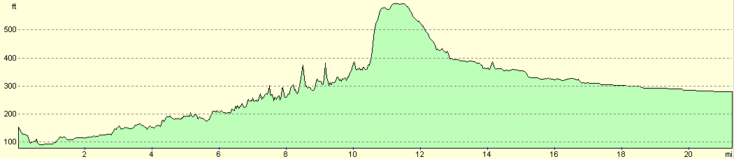
For more information on profiles, ascents and descents, see this page
Accommodation
I spent the night camping in a field next to a house in Ashton Keynes, with the owner's permission.
Disclaimer
Please note that I take no responsibility for anything that may happen when following these directions. If you intend to follow this route, then please use the relevant maps and check the route out before you go out. As always when walking, use common sense and you should be fine.
If you find any information on any of these routes that is inaccurate, or you wish to add anything, then please email me.
All images on this site are © of the author. Any reproduction, retransmissions, or republication of all or part of any document found on this site is expressly prohibited, unless the author has explicitly granted its prior written consent to so reproduce, retransmit, or republish the material. All other rights reserved.
Although this site includes links providing convenient direct access to other Internet sites, I do not endorse, approve, certify or make warranties or representations as to the accuracy of the information on these sites.
And finally, enjoy your walking!
Nearby walks
| # | Title | Walk length (miles) |
|---|---|---|
| 617 | Cotswold Way: Tormarton to Dursley | 19.9 |
| 618 | Cotswold Way: Dursley to Painswick | 16.7 |
| 619 | Cotswold Way: Painswick to Dowdeswell Reservoir | 18.2 |
|
|

|