Walk #796: Romsey to Salisbury via Dean Hill
 |
 |
|
General Data
| Date Walked | 09/11/2007 |
| County | Hampshire, Wiltshire |
| Start Location | Home in Romsey |
| End Location | Salisbury station |
| Start time | 07.16 |
| End time | 16.18 |
| Distance | 23.6 miles |
| Description | This was a very pleasant walk, including a long and exposed ridge walk with some superb views. |
| Pack | Today I carried my 30-litre Karrimor rucksack, filled with waterproofs, a book and other odds and ends. |
| Condition | I had a little trouble with my left knee at one stage, and also with my left ankle. |
| Weather | Aside from an early, brisk shower, the day was crisp and clear, initially without many clouds in the sky, although it clouded over as the day went on. There was a brisk and chilly northerly wind that caused me discomfort at times. |
| OS map | Landranger number 185 (Winchester & Basingstoke, Andover & Romsey) and Landranger number 184 (Salisbury & The Plain, Amesbury) |
 |
 |
|
 |
 |
|
Map of the walk
Maps courtesy of Google Maps. Route for indicative purposes only, and may have been plotted after the walk. Please let me have comments on what you think of this new format. For a detailed table of timings for this walk, please see the table file.
 |
 |
|
 |
 |
|
Notes
I felt like doing a walk from home today, so I set off to walk to Salisbury by a different route from the one I had taken last month. This route promises to be both longer and more interesting than the previous walk. I set of in good spirits, following the Tadburn Lake and stream towards the centre of the town, before joining the old barge canal (part of the old Southampton to Andover canal) to reach the station. This was a much more logical place to start the walk, but would have involved me having to park there for the day - not necessary when my home is such a short distance away.
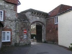
Romsey is a lovely, genteel town, and it is already starting to feel like home, even though I have only lived here for a few months. It is filled with lots of interesting and old buildings, the best of which is the massive Abbey Church that dominates the town. Unfortunately a few spots of rain fell on my face as I strolled along the roads in the town; the grey cloud overhead appeared threatening.
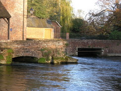
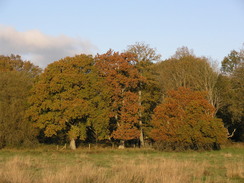
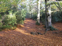
I joined the Test Way at the bridge over the River Test and started following it northwards. Soon I reached Saddler's Mill - a beautiful building in a lovely setting. After this the path left the river and headed across the floodplain - not a particularly good stretch of walk, especially as I have now done it several times. Things improved when the path dived into Squabb Wood - I saw a deer close-by on the left; it watched me for a few seconds before running off. A thick carpet of leaves lay on the ground, browns oranges and reds that my feet rustled through as I walked. It would be good to walk through virgin snow in this wood, but somehow I doubt that I will ever get the opportunity.
Shortly after leaving the wood I left the Test Way, and instead took paths that headed above Awbridge Danes Lake. My left knee started aching at this point, a disconcerting indication of a past injury coming back to haunt me. The sun was low in the sky, and the shadows lay long on the ground, even though it was past nine. Glimpses of the lake were visible through the trees, although it was annoying that there were not better views. The trees kept the wind off me as I walked, and out of the wind it felt surprisingly warm.
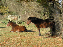
A path led me across Dunwood Manor Golf Club, heading uphill and entering an area of woodland before descending and ending at a road in Newtown. Another path took me westwards across Doctor's Hill; the path was not too good, with pplenty of stiles to make the going annoying. A horse came to see me in one field, sniffing around me and my pack, and allowing me to pat it from the safety of the other side of the stile.
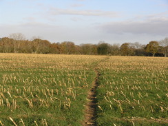
A road track, and footpath took me towards Gambledown Farm. To the left there were works for a pipeline, and I wondered if this was the same pipeline I had seen being built near Brockenhurst recently. A sign said it was a 14" diameter pipeline for Esso. Views started to unfold as I approached Gambledown Farm, where cows were being herded in, and then a footpath took me on northwestwards.
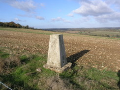
The path slowly started to climb towards Deanhill Barn. Just before this was reached there was a pillbox - an unusual spot, so I thought, as there did not seem to be any natural route of importance to be guarded. I headed down a track for a short distance to reach a trig pillar; I took some photos of this through the hedge, then headed back to start following the ridge westwards.
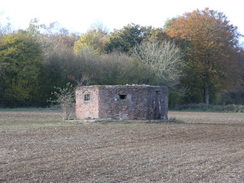
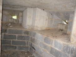
A tall barbed-wire fence soon started on the right with MOD warning signs, marking the southernmost extent of the massive Dean Hill munitions depot, now sadly closed. A row of brick-lined, concrete pillboxes followed the path along. Small stalactites two or three inches long hung down from within the ceiling in one of these; lime coming out of the concrete. Five or six of the pillboxes sat in a row, some overgrown with others much more exposed.
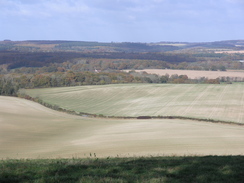
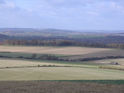
A Wilsthire County Council footpath sign showed me that I had crossed the border from Hampshire. The views over the fence to the north were superb, and I was amazed that I could be in such beautiful countryside less than ten miles away from my home. The fence ended near a large transmission mast, and I then got my first view of the spire of Salisbury Cathedral in the distance.
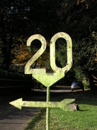
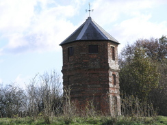
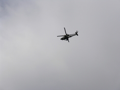
I kept on admiring the views as I walked on. Near the White House there was a yellow railway 20 MPH sign on the left, an unusual and funny sight. An army helicopter flew low overhead in the opposite direction, disappearing into the distance. The walk on the ridge was a superb stroll. I ignored a trig pillar marked on the map to the left, and headed down past a strange brick folly tower called The Pepperbox, a folly built in 1606. I resisted going to have a look at this, and instead headed down a steep track cut into the chalk to reach a main road.
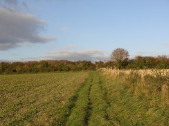
It took me a couple of minutes to safely cross the main road, and then a by-way took me on southwestwards across Witherington Down. Salisbury Cathedral was clearly visible in the distance, and I could not believe in having such a god walk so close to my home - it beats anything I have ever done in Cambridgeshire.
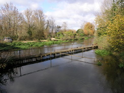
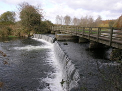
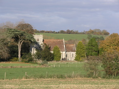
The track ended at a road, which led me to a bridge that led over an old railway line from Salisbury to Poole that shut in 1964. Shortly after this the road plunged downhill, and I took a footpath that climbed up into the woods in Trafalgar House. It skirts past a large house, then starts angling downhill. At the bottom of the hill it reaches an old mill by the River Avon. This was a very pleasant spot; a series of bridges and paths took me across the mill leats and streams to reach a long bridge over a weir. A woman stopped to show me a photo she had taken a few days previously - the trees looking glorious with red and yellow leaves. Sadly the recent heavy winds had freed the trees of their burden.
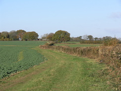
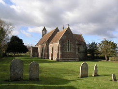
The path led me into the hamlet of Charlton, where I joined the Avon Valley Path. Two Apache helicopters flew overhead in formation - a fantastic sight, and a sign of how close I was to Salisbury Plain. Soon I passed Matrimony Farm, leading me to wonder how it had got its name. A series of fairly undistinguished footpaths took me on to Odstock. Although I was really starting to enjoy the stroll I was getting tired, and I decided to nip into the Yew Tree Inn. I had a couple of pints of Copper Ale to wash down some peanuts, warming myself up before heading out once again.
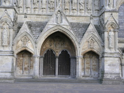
The Avon Valley Path took me onwards, crossing the River Ebble before climbing once more, passing Dogdean Farm and eventually reaching the A354 at the top of the hill. A slightly zig-zagging course took me into Harnham, and the path headed down the wooded Harnham SLope, with a steep hillside off to the left. The bottom of the slope marked my entrance into Salisbury; a road took me over the River Avon, and I then diverted off to walk past the Cathedral.
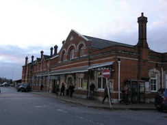
Salisbury Cathedral is an impressive structure; possibly one of the best cathedrals in the country. The stone seemed to glow in the sunshine, and it was a shame that I could not hang around for too long. Instead I headed on, soon reaching the station. The train back to Romsey was packed - far busier than I can remember being in before - and I reached Romsey just before five. Then I was faced with the walk back to my home, after what had undoubtedly been a superb day's walk.
 |
 |
|
 |
 |
|
Directions
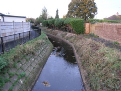
This walk starts off at my home on Saxon Way in Halterworth in Romsey. The first stage of this walk is a mile to Romsey station, which is an alternative start point. The route I took was to walk down Halterworth Close, and when this bends to the left go past a house and turn left to join a footpath. Follow this behind houses, and then turn right to descend to a bridge over the Tadburn Stream. On the other side of the bridge turn left to walk westwards along a track with the stream on the left. This runs through the Tadburn Meadows Nature Reserve; when this ends at a road walk alongside the stream, initially with it on the left. A couple of roads are crossed before the path crosses over so that the stream is on the right, It ends at Botley Road.
Cross Botley road and continue on along a path with the stream on the right. The path squeezes under a railway bridge and ends at a road. Turn right to cross a road bridge over a stream, and then head straight on along a path that squeezes behind houses before ending at the A3090 Winchester Road. Cross the road and turn left, and at a road junction on the left turn right along a path that squeezes to the left of a theatre. It joins a stream on the right; just before a railway bridge is reached turn left along a footpath that heads westwards, joining a minor road. A few yards along this there are some steps leading up; climb these and turn right to reach Romsey railway station.
Now the walk proper begins. Leave the station and head down the station approach to the A3057. Cross this, and head straight on down Station Road. This curves to the left and becomes Latimer Street before it ends at The Hundred. Turn left for a few yards and then right, to head along a narrow alleyway between buildings that ends at a road. Turn right past the bus station to a stream, and then turn left with the stream on the right towards a co-op. Keep the stream on the right as a path heads down some steps and ends at a road. Turn left down this road and then right to start walking down Middlebridge Street southwestwards. This ends at the A27 near a bridge; continue straight on for a few yards to a bridge over the River Test.
Just after the bridge turn left to follow a track northwards, with the river on the right. When Saddler's Mill is reached turn left and then right, to join a footpath that heads northwestwards along the floodplain of the river, heading to the east of the sewage works. A couple of small plank footbridge lead over a couple of streams, and three-quarters of a mile after the mill the path reaches Squabb Wood near Monk's Cottages.
Enter the woodland, and follow a footpath that leads northwestwards through the trees, heading to the west of Roke Manor. At SU333222 turn right down a path that heads northeastwards off the main path; this soon leaves the trees into a small clearing, before re-entering the trees for a short period. After it leaves the trees again it turns to the left, skirting the northern edge of the woods to the edge of a field, and then turning right to head northwestwards for a short distance to Old Salisbury Lane.
Cross the road and head across two fields; halfway across the second the Test Way heads off to the right; ignore this turn. A stile leads out of this second field into some trees, and then turns to the left to head westwards for 0.6 miles to the south of Awbridge Danes Lake. This ends at a road; turn right to head northwards for a few yards and then turn left down the access road to a golf course. At the clubhouse turn partially right to head northwestwards along a track. This climbs uphill and enters trees, before descending down and emerging from the trees to end at Newtown Road.
Turn right along Newtown Road for a few yards and then turn left to take a footpath that heads due westwards over Doctor's Hill, crossing a series of paddocks. After half a mile of sometimes enclosed paths it reaches another path; follow this west with a pond to the north, and then at a T-junction turn right to head northwards until the path ends at a road.
Turn left to head westwards down this road for a hundred yards. When the road starts to curve to the left, turn right along a track that heads northwards, before curving to the left to end at Gambledown Farm. The track continues on to Owls Farm, and when it ends turn right to head northwestwards along a footpath for half a mile. It then runs along the eastern edge of a patch of woodland, before turning to the eight and then left to head to a complex footpath junction near a ruined barn. Turn right to go through another field and then immediately to the left to head northwards, down into a little valley and then continuing uphill until the path ends at a track immediately to the east of Deanhill Barn.
Follow this track westwards towards the farm, and on the far side of this turn half-right to follow a footpath that heads westwards along the top of a ridge for a mile and a half, with a large fence for a military base on the right and a line of pill boxes on the left.Cross a road and continue on westwards along a track for 2.7 miles, passing White House and then skirting to the north of Pepperbox Hill before reaching the A36(T).
A short track leads down to the road; carefully cross this, and take a track that leads uphill onto Witherington Down. This track becomes a path that continues on for 0.8 miles before ending at a sharp right-angle bend in a road. Turn right to follow this road westwards for half a mile to a road junction near Standlynch Lodge; turn right to head downhill and then take a footpath that heads up to the left through trees from opposite the entrance to Standlynch Farm. At the top of the climb the path turns slightly to the right to start heading westwards right past Trafalgar House, before curving slightly to the left and descending downhill to reach a mill by the River Avon.
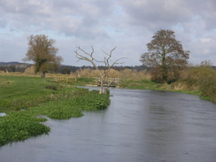
Cross the first stream to reach the mill and then turn right, following a footpath that heads north for a short distance to a footbridge. Cross the bridge and follow the path as it heads westwards across the floodplain. When the path forks, take the right-hand branch that ends at a road in Charlton. Turn right up this road for a short distance, and follow it as it curves to the left near the church. A few yards further on, turn right to join the Avon Valley Path.
The path heads northwestwards across fields before meeting a road at SU170245. Turn right along this road and follow it northwards until just after Matrimony Farm, and then turn left along another footpath that heads northwestwards for a short distance before ending at the A338 road. Cross the A338 and turn left for a few yards before turning right uphill along a bridleway to the west. After a tenth of a mile turn right to join a footpath that initially heads northwards, passing under some power lines before curving to the left to take a more westerly course.
The path meets a road to the south of Nunton; follow this road westwards for a couple of hundred yards, and when it curves to the left continue straight on along another footpath that heads for a little over half a mile to another road. Cross this road and take a footpath onwards that soon curves to the right to end at another road. Head down this road, and when it curves to the right turn left along another footpath. This heads slightly north of west for about half a mile to a footbridge over the River Ebble, and then heads northwestwards to a track. Cross the track, and on the other side climb uphill to the north along another track. At Dogdean Farm, the track curves to the left to head westwards, and then turn right to follow another path northeastwards for 006 miles until a crossroad with another track is reached at SU137279.
Turn left along a track for 0.4 miles to the A354 road; cross this, and continue along a track on the other side for a short distance. Turn right to heads eastwards, and just after the first house on the right turn left to take a footpath that heads northwards across Harnham Hill, with houses on the right. When this ends at a T-junction with another track above Harnham Slope, turn right to head eastwards along the track. This slowly descends down before ending at Old Blandford Road. Turn left and follow this road for a short distance down to the A3094. Turn right and then left, to follow a road that heads northeastwards, reaching a bridge over the River Avon.
Continue north along this road from the bridge, and when it curves to the right turn left along another road and then right to head up towards the cathedral. Pass the cathedral, and continue northwards along a road that heads through a gateway. Turn left after this, to head westwards along Crane Bridge Road. This crosses a stream and then curves to the left, becoming Mill road. This curves to the right to head northwards; pass the junction with Churchfields Road on the left, and then a little further on turn left to walk up to Salisbury railway station, where this walk ends.
 |
 |
|
 |
 |
|
Distances
| From | To | Distance (m) | Ascent (ft) | Descent (ft) |
|---|---|---|---|---|
| Home in Romsey | Romsey station | 1.2 | 16 | 72 |
| Romsey station | Deanhill Barn | 7.6 | 702 | 387 |
| Deanhill Barn | Odstock | 10.0 | 571 | 774 |
| Odstock | Harnham | 3.0 | 292 | 164 |
| Harnham | Salisbury station | 1.8 | 23 | 148 |
This makes a total distance of 23.6 miles, with 1604 feet of ascent and 1545 feet of descent.
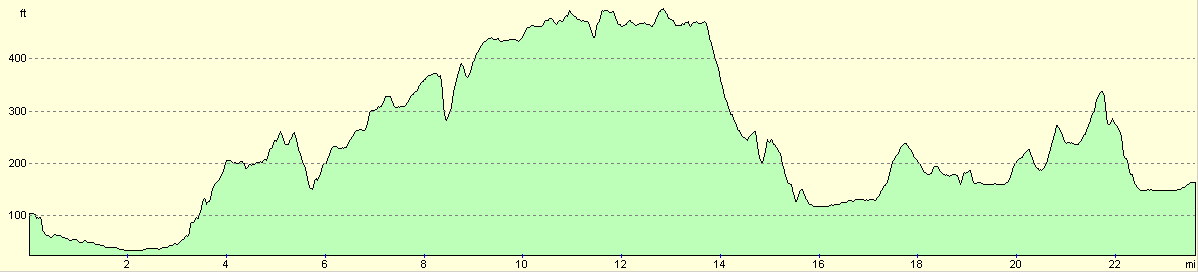
For more information on profiles, ascents and descents, see this page
 |
 |
|
 |
 |
|
 |
 |
|
 |
 |
|
Disclaimer
Please note that I take no responsibility for anything that may happen when following these directions. If you intend to follow this route, then please use the relevant maps and check the route out before you go out. As always when walking, use common sense and you should be fine.
If you find any information on any of these routes that is inaccurate, or you wish to add anything, then please email me.
All images on this site are © of the author. Any reproduction, retransmissions, or republication of all or part of any document found on this site is expressly prohibited, unless the author has explicitly granted its prior written consent to so reproduce, retransmit, or republish the material. All other rights reserved.
Although this site includes links providing convenient direct access to other Internet sites, I do not endorse, approve, certify or make warranties or representations as to the accuracy of the information on these sites.
And finally, enjoy your walking!
Nearby walks
| # | Title | Walk length (miles) |
|---|---|---|
| 308 | Southampton to Fawley | 16.4 |
| 787 | Romsey to Eastleigh via Winchester | 21.1 |
| 788 | Romsey to Salisbury | 23.1 |
|
|

|