Walk #736: Thames Path: Ashton Keynes to Rushey Lock
 |
 |
|
General Data
| Date Walked | 27/08/2006 |
| County | Wiltshire, Oxfordshire |
| Start Location | Ashton Keynes |
| End Location | Rushey Lock |
| Start time | 06.42 |
| End time | 18.04 |
| Distance | 26.0 miles |
| Description | This was a very long day's walk following the Tahmes Path as it heads eastwards, as the river slowly grows in size from being a trickling stream to a large, proper river. |
| Pack | Today I carried my 80-litre Macpac Glissade rucksack, containing a North Face Blue Kazoo sleeping bag, my Jack Wolfskin Gossamer tent, clothes, waterproofs and other camping items, excluding cooking gear. |
| Condition | I am very tired after this walk, which is to be expected after such a long day with full pack. I have a couple of nasty sore spots on my feet, including one on my right heel that has been bleeding freely. |
| Weather | Today has been a lovely, sunny day, and although there was a fair amount of cloud cover at times it got quite hot through the day. |
| OS map | Landranger number 163 (Cheltenham & Cirencester, Stow-on-the-Wold) and Landranger number 164 (Oxford, Chipping Norton & Bicester) |
 |
 |
|
 |
 |
|
Map of the walk
Maps courtesy of Google Maps. Route for indicative purposes only, and may have been plotted after the walk. Please let me have comments on what you think of this new format. For a detailed table of timings for this walk, please see the table file.
 |
 |
|
 |
 |
|
Notes
My sleep during the night had been interrupted by music playing in a field nearby, the DJ singing over some songs. It was about one in the morning, and lasted for about an hour before he announced that they had been told that they had to stop the music. Unfortunately many of the songs had been ones that I liked, and this prevented me from shutting out the music from my mind and going back to sleep, as I would focus on the music.
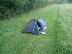
Consequently when I woke up in the morning I was quite tired, and I strolled around the field for ten minutes, stretching my legs before eventually packing up my tent and other gear and filling up my water bottle. It had been very kind of the couple to allow me to sleep in the field and use their water supply, and I tried to make no noise as I walked down the gravel drive and opened the gate to reach the road in Ashton Keynes. The village was very quiet on this Sunday morning, and as I walked on the road through the village I listened to reports on Radio Five about a Rave by the M11 in Great Chesterford that had been broken up by police - the music overnight had sounded a little like that, but I doubt that the music would have carried that far!
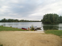
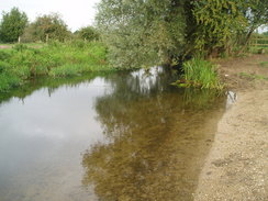
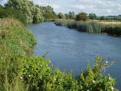
After crossing a playing field the path followed a path that passed between some lakes, the remains of gravel pits that have been flooded. It was a fairly ordinary stretch of path, and I was disappointed that the lakes hid any sight of the Thames. Just before a road was reached another bridleway headed off, running around the edge of several lakes in the Cotswold Water Park. The grass underfoot was wet with dew, and as the path wound around Manorbrook Lake my boots got thoroughly wet - fortunately none of this got inside to my feet. The path really wound around the lakes and was made for a fairly boring walk, and it was a relief when they were left behind and the path headed on to rejoin an old railway line for a short period. It then rejoined the Thames again, which was wider than it had been at the end of yesterday (I assume that the water held in the lakes helps regulate the flow in the river through the summer).
The path soon crossed over an old embankment that had once carried a canal, and head across North Meadow, a nature reserve on an ancient stretch of meadowland. It was a pleasant early morning stroll, and it was a shame when this ended as the path skirted across fields to the north of Cricklade. A road was soon reached near the bridge over the Thames, and I turned right to pass the Norman St Mary's church. The trail soon headed off to the left to lave the town, but I headed on for a short distance through the beautiful town, passing the police station to reach a shop where I bought a few snacks. I then headed back to the police station, and sat outside munching away on the food. The town is very attractive, and it made for a good place to stop for a break - indeed, it is somewhere that I would not mind exploring more in the future.
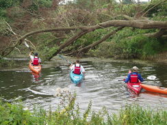
Once I had finished eating I was starting to get a little chilly, and so I decided to head on once again. A road took me eastwards out of the town, and just before a meadow I came across some canoeists launching themselves at a slipway. The path headed under the A419(T) on a low bridge, and continued on along the southern bank of the river to Eysey footbridge, where it swapped over to the other bank. Shortly after I crossed I hard voices and six canoeists went under the bridge, soon having to stop where a fallen tree spanned the river from bank to bank. The first canoeist found a way though between branches and the others quickly followed, either taking that gap or another one. As they paralleled me I had a quick chat, and it turned out that they were on a canoe trip down the Thames as far as Teddington. I wished them luck as they soon pulled away ahead of me.
About a mile later the towpath swapped over back to the southern bank via the Water Eaton footbridge, and the towpath beside the narrow Thames was easy to follow as the river wound around northeastwards. The guidebook stated that a new path was soon to open following the river towards Castle Eaton, but that at the moment the path diverted up to the road near Water Eaton Cottages. It seemed as though the path diverted off to the road, so I pressed on through a field of high plants (corn?) to the road, which proved to be hard going. When I reached the road I discovered that the path had actually run along the other side of the hedge, which would have been much easier going.
The road took me on into Castle Eaton, diverting back towards the river for a short period before heading past the church and away from the river along a road. Another road took me eastwards along a very quiet lane for a mile to Blackford Farm, and here the path rejoined the towpath beside the river. Just as I met the river I heard voices, and was startled to see the canoeists I had met a couple of hours earlier. They seemed as startled as I was, and the fact that they had only just reached this point showed just how much the river wound around in comparison to the path after it head left the river. A little further on I came across a man with his children who had just caught some freshwater crayfish, which he gleefully told me were free to fish, and that fishermen actually liked people catching as they eat fish eggs. He said that he was going to have them for dinner and I found myself slightly jealous - it must be lovely to eat food that you have freshly caught.
After a few hundred yards the towpath left the immediate vicinity of the river bank and headed eastwards, and here I made a mistake, crossing over a dirt ditch and following the northern side of a hedge. Unfortunately when I reached the other end of the field I found that I could not cross the hedge or ditch, which was now full of water, and so despondently I walked back to the dry section and crossed over, before heading along the other side of the ditch and hedge. When I reached Hennington Bridge a kilometre later I stopped for a rest by the gate that led onto the road, and it was really nice to stop. I took my boots off for a while and read a book whilst I relaxed, and by the time I finally decided to head off once again I felt much better.
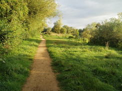
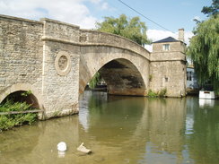
For the next few miles the path kept away from the river, heading along a road before taking the bridleway to Inglesham. It is a shame that the path cannot follow the river, but the bridleway made for a good alternative and it was a fairly enjoyable stretch of walk. This, however, ended at Upper Inglesham, where the bridleway joined the A361 road, following it northwards. There was no pavement and in a couple of places the verge was narrow on bends, making this stretch less than enjoyable. After a mile the trail thankfully left the road, turning left to head down to Inglesham Church. It took me a few minutes to wait for a gap in the seemingly never-ending traffic to cross the road, but once this was done it took me no time to reach the church.
It was tempting to go and visit the church, but as I was keen to move on I kept on the trail as it rejoined the river for the first long distance in many miles. It was a pleasant walk and was fairly busy, and the reason for this soon became obvious with the approach of Ha'penny bridge and the town of Lechlade. It was tempting to nip into the town for a look around, but I still had around seven miles to walk, so I decided to stroll on. The views into Lechlade from the river were good, and the town also marked the furthest point upstream where the Thames can be navigated (the Thames and Severn canal left the river a little to the west). For this reason I was startled to see some fairly large boats on the river, and this reminded me how much the river had widened since I had first seen it this morning.
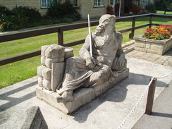
The river wound around eastwards for a mile before reaching St John's Lock, where the statue of old Father Thames lay recumbrant looking over the lock. He used to be situated at the source of the Thames, but was moved here, where it fits in much more. The lock was very attractive and well maintained, and there was scarcely a stone out of place, a fact not lost to the people I chatted to on the two boats who were using the lock to go downstream. A few yards further on was St John's bridge, and I used this to cross the river to get to the Trout Inn. This was fairly busy, and I went inside to have a drink and some food. Unfortunately it turned out that there was a wait for food, but I was in a need of sustenance and so I decided to wait inside, supping at a pint of bitter and another of orange and lemonade as the minutes slid by.
As I waited two other backpackers walked past outside, and after a few minutes one of them came in to order some drinks. They were walking the path as far as Teddington, and had spent the night camped up a hill to the east of Cricklade. They had had no water overnight, and had walked the miles to Lechlade without any water, which had led to them being desperately thirsty by the time that they had reached the town. Consequently they had spent a couple of hours there, and had called in at this pub as well for more drink. I wished him luck as my food arrived, and I tucked in. Before I had finished the pub had nearly emptied, and where there had been a queue at the bar there was now no-one waiting. After I had eaten I sat around reading, noticing the other backpackers about ten minutes before I finally shouldered my rucksack and left the pub.
After recrossing the bridge I followed the towpath along the southern bank of the river for a few hundreds yards to the Bloomer's Hole footbridge, which the trail crossed to reach the northern bank of the river. As it headed southeastwards and then eastwards the river curved in loops of different sizes, which proved annoying to my weary and tired feet. Alongside the river were some old Second World War pillboxes, the remainder of GHQ Stop Line Red, the last defensive line before the Midlands that ran from Malmesbury to the west of Reading, and these just served to illustrate the arcs that river transcribed across the landscape.
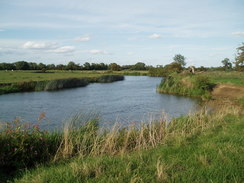
The bends continued after Buscot Lock, but the river settled on a more easterly course as it heads the couple of miles towards Kelmscott. It was a pleasant and scenic walk in the afternoon sunshine, but my feet and legs were starting to ache, and every mile proved to be increasingly hard. At Kelmscott a track was joined for a short distance, but before I knew it this was left behind and the path continued along the riverside along grass. About a mile further on I decided to stop for a rest, taking my book out once again and phoning up Sencan for a chat, which proved to be very morale-boosting. Eventually I wearily shouldered my pack and headed on along the path.
Fairly soon I reached Radcot Bridge, which was crossed to reach the other side of the river. There was also a campsite here, and it struck me that the upper reaches of the Thames had many campsites from which to choose, but the one I had booked into was another few miles further on yet. I therefore ignored the pub and attendant campsite, which seemed fairly busy, and headed on along the towpath. The river continued in a series of meanders that seemed to be never-ending to my tired feet and legs. Some of the meanders were very narrow, and from the tracks on the ground it was obvious that the majority of people just cut across them, in many cases a saving of only a few yards. I was not in a mood to do any different, and what I had thought was only two miles to Rushely Lock turned out to be a long and fairly debilitating three.
The walk to the lock seemed to last forever, and when I passed the stack of paddles to reach the lock I was utterly and totally tired out. The lockkeeper was in the hut by the lock, and it seemed to take hours for him to write out the ticket as we chatted away. The canoeists had recently been through and their wives had been waiting at the lock for a while - apparently they had been delayed at the pub in Lechlade, something that I could not blame them for. The two backpackers had also been through a while before, but my thoughts were only of putting my tent up and crawling inside. It had been a twenty-six mile walk, my longest of the year so far, and had been hard - especially so as I had been carrying full walking kit.
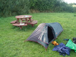
It cost me four pounds fifty pence to stay for the night, and after I had paid the lockkeeper took me across to the camping area, which was situated amongst some picnic tables. I was alarmed to find a distinct odour hanging around the area, but he explained that someone had just washed out their lavatories and the smell would soon pass. He was right, and after my tent was up I walked over to the small toilet block to prepare for the night, before which I laid my sleeping bag out to dry on one of the picnic tables - it had got damp the previous night when touching the interior of the tent.
The evening was gloriously sunny, so I lay me inflatable mat out on the grass as I read a book, enjoying the last vestiges of the daylight. After a while I took my boots and socks off, to find to my alarm that the back of one of my heels had a large and painful blister on it. I searched through my rucksack but was alarmed to find that I had left my medical kit at home, a stupid mistake. This meant that there was little that I could do about the blister, but I was more alarmed about some blood that had formed on my Achilles tendon where my boots had rubbed.
As I had been uncomfortable having my large rucksack in my tent with me last night, I decided to risk leaving it outside overnight tonight. I wrapped a large plastic rucksack liner around it and left it our of sight in a hedge, getting pricked by a bramble for my troubles. This made my small tent so much more roomy, and I think that I shall have to do this more in the future - it is nice to be able to turn around in my sleep without being constrained by the pack beside me - the tent is scarcely big enough for me as it is.
 |
 |
|
 |
 |
|
Directions
| The walk is also covered in detail in the Thames Path National Trail Guide, by David Sharp, ISBN 1-84513-062-6 published by Aurum Press Ltd. Click on the image to the right to go to the Amazon page for the book. | 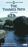 |
 |
Distances
| From | To | Distance (m) | Ascent (ft) | Descent (ft) |
|---|---|---|---|---|
| Ashton Keynes | Cricklade | 5.5 | 56 | 69 |
| Cricklade | Castle Eaton | 4.0 | 43 | 59 |
| Castle Eaton | St John's Bridge, Lechlade | 7.8 | 52 | 66 |
| St John's Bridge, Lechlade | Rushey Lock | 8.7 | 39 | 52 |
This makes a total distance of 26.0 miles, with 190 feet of ascent and 246 feet of descent.

For more information on profiles, ascents and descents, see this page
Accommodation
I spent the night at the little (only five pitches) campsite at Rushey Lock, which ost me £4.50 for the night. There are several locks along the Thames Path that allow camping for walkers, The lock is near Tadpole Bridge, and can be phoned on (01367) 870218 before 19.00 in the evening.
Disclaimer
Please note that I take no responsibility for anything that may happen when following these directions. If you intend to follow this route, then please use the relevant maps and check the route out before you go out. As always when walking, use common sense and you should be fine.
If you find any information on any of these routes that is inaccurate, or you wish to add anything, then please email me.
All images on this site are © of the author. Any reproduction, retransmissions, or republication of all or part of any document found on this site is expressly prohibited, unless the author has explicitly granted its prior written consent to so reproduce, retransmit, or republish the material. All other rights reserved.
Although this site includes links providing convenient direct access to other Internet sites, I do not endorse, approve, certify or make warranties or representations as to the accuracy of the information on these sites.
And finally, enjoy your walking!
Nearby walks
| # | Title | Walk length (miles) |
|---|---|---|
| 735 | Thames Path: Stonehouse to Ashton Keynes | 21.3 |
|
|

|