Walk #250: Boston Station to Holbeach St Matthew
 |
 |
|
General Data
| Date Walked | 29/10/2002 |
| County | Lincolnshire |
| Start Location | Boston Station |
| End Location | Holbeach St Matthew |
| Start time | 07.11 |
| End time | 14.02 |
| Distance | 20.7 miles |
| Description | This was a nice walk following sea banks around the western side of the Wash, following the channels of the rivers Welland and Witham. |
| Pack | Today I carried my 30-litre Karrimor HotRock rucksack, which was filled with my packed lunch, waterproof coat, water bottle and a couple of spare shirts, together with the usual assortment of odds and ends. |
| Condition | I am absolutely fine after this walk, and could easily have walked further if I had needed to. |
| Weather | The weather today was dominated by rain showers that came down from a cloud filled sky. At first the showers were very light and infrequent, but in the early afternoon a shower started that lasted for a couple of hours. This was not a heavy shower, but it was heavy enough to get me fairly wet by the time I finally met Sam. Despite this it was quite a warm day, and I did not get cold at all. |
| OS map | Landranger number 131 (Boston & Spalding) |
 |
 |
|
 |
 |
|
Map of the walk
Maps courtesy of Google Maps. Route for indicative purposes only, and may have been plotted after the walk. Please let me have comments on what you think of this new format. For a detailed table of timings for this walk, please see the table file.
 |
Notes
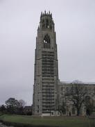
The Boston Stump, the tower of St Botolphs church, dominated the first part of the walk. At 272 feet high it is the tallest parish church tower in England (although see this site for why this is a bit of a misnomer) and it dominates the whole of the surrounding area. The church was started in 1309 and completed (without the tower) in 1390. The tower was started in 1425 and work was completed sometime around 1520. Unfortunately I cannot say that I found it very pleasing to the eye; the tower looks rather 'busy' and messy, although I did only see it from one side, and pictures I have seen from other angles look less cluttered.
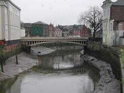
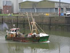
The port at Boston is alongside the river, and it looked fairly busy. On the way there were the remains of several sunken wooden boats embedded firmly into the mud - the skeletal remains were quite fascinating, especially as a couple of them were still tied up to the quayside! Whether anyone expected them to get out of the mud and float away I do not know, but it strikes me as being nigh on impossible due to the state that they were in. There were a couple of big boats in the port, and it made me wonder what gets shipped to and from the port; grain perhaps? A little research on the Internet shows that 1,500,000 tons of cargo is handled per year, comprising mainly of steel, paper and timber, and not the grain that I had expected.
A sad aside to the port was the condition of the railway line which feeds the port; this crosses the river by the means of a fascinating swing bridge which I passed early on in the walk, although unfortunately the condition of the tracks led me to think that no trains had been along it in a while.
As I was walking along the Macmillan Way along the southern bank of the river to the south of Boston a great swarm of white birds became visible. These signalled my approaching of the tip which I had seen from the other side of the river yesterday. The ground in this area was also fairly disgusting, leading me to wonder whether the pit had at one time been nearer to the river and had slowly moved away.
It had been my intention to visit the Ship Inn in Fosdyke Bridge to celebrate having completed my five hundredth mile on this trip. I visited this pub earlier in the year when I had done the walk from Boston to Fosdyke Bridge and had been made very welcome, so I was looking forward to visiting it again. Unfortunately the pub was shut, and so I got my sandwiches out and walked on.
Tomorrow I will have to walk back up to the sea once more from Holbeach St Matthew so that I can continue the walk eastwards. Unfortunately the first few miles of this is through the Holbeach ariel bombing range and when I left this afternoon the red flag was flying, barring access. If this is the case tomorrow morning I shall have to try and find a more inland route, avoiding the danger area.
Directions
This walks starts at the railway station in Boston. From the car park in Boston take Lincoln Lane that heads eastwards towards a supermarket and the River Witham. At a bridge over the river near the imposing spire of St Botolphs Church, turn right and head along the High Street as it follows the western bank of the river through the town. The path soon meets a road, which can be followed southwards until the A16(T) is reached in the centre of the town.
Cross straight over the A16(T) and continue southwards down the High Street. The river is left behind for a short distance until it is regained again, the road becoming London Road in the process. Shortly after this a railway level crossing is reached, with a swing bridge in the middle of the river beside it. A short distance after this a bridge carries the road over the South Forty Foot Drain where it meets the River Witham. Cross this bridge to get to the southern side of the Drain.
From here the Macmillan Way can be followed to the end of the walk. On the southern side of the bridge turn left and climb up to some grassy banking that leads eastwards along the southern edge of the River. After about half a mile it passes under two sets of power lines before swinging to head south-eastwards. It continues in this direction for four and a half kilometres until the Haven is reached.
At TF 365 392 some care has to be taken as two paths diverge along the top of two banks; a dead-end one heads eastwards towards the sea whilst the Macmillan Way continues on to the south-eastwards. A short distance after this junction the path turns ninety degrees to head south-westwards towards Frampton Marsh.
The way is very easy to follow from here as it remains on the top of the flood banking as it winds its way south-westwards. A final zigzag brings the flood banking to the northern side of the River Welland. It passes under some power lines and about a mile later it meets the bridge that carries the A17(T) main road over the river. Cross the river using the road and walk pat a pub. Immediately on the other side of the pub a track leads off to the left past a little parking area. Go down this track which is beside the bridleway which runs on top of the bank to the left.
Before the track ends climb the bank to the left and continue on along the bridleway on the top of the bank. Follow the bank as it heads north-eastwards, going under some power lines and passing two lakes on the left before going around an area of trees which form a nature reserve and reaching a car park. Go through the car park and then turn left along a wide unsurfaced track that leads up onto the top of the sea bank once more by a quay.
At the quay turn right and continue on along the top of the sea bank. This slowly curves around to a more easterly heading beside Fosdyke Wash. Near the end of the Wash the official bridleway turns to the right to go south for a kilometre down one side of a narrow area of land and then up the other side; this long diversion is unnecessary as there is a concessionary bridleway along the top of the sea bank which joins the two bridleways up.
The bridleway then turns to head north-eastwards for a short distance before turning to the right along the sea bank. At a couple of places the bridleway makes small diversions inland along smaller sea banks, but I walked a more direct route along the top of the main sea bank at these places with no problems. The bridleway ends after the second diversion, but I continued on for another kilometre to a sluice.
At the sluice turn right and walk down a track that heads southwards for about a kilometre before ending at another track. Turn left down this track and follow it for a short distance until it becomes a surfaced road, and then continue on along this road as it winds around in a rough southerly direction towards Holbeach St Matthew.
Distances
| From | To | Distance (m) | Ascent (ft) | Descent (ft) |
|---|---|---|---|---|
| Boston Station | End of The Haven | 5.2 | 69 | 66 |
| The Haven | Fosdyke Bridge | 6.4 | 20 | 23 |
| Fosdyke Bridge | Holbeach St Matthew | 9.1 | 36 | 30 |
This makes a total distance of 20.7 miles, with 125 feet of ascent and 119 feet of descent.
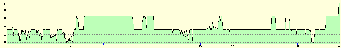
For more information on profiles, ascents and descents, see this page
Accommodation
We stayed at Delph Bank Touring Caravan and Camping Park, Old Main Road, Fleet Hargate, Holbeach, Spalding, Lincolnshire, PE12 8LL. They can be contacted on 01406 422910 and they have a website at www.ukparks.co.uk/delphbank. This was a lovely little site that was well maintained and clean. It cost us ten pounds for the night, including electricity hook up.
Disclaimer
Please note that I take no responsibility for anything that may happen when following these directions. If you intend to follow this route, then please use the relevant maps and check the route out before you go out. As always when walking, use common sense and you should be fine.
If you find any information on any of these routes that is inaccurate, or you wish to add anything, then please email me.
All images on this site are © of the author. Any reproduction, retransmissions, or republication of all or part of any document found on this site is expressly prohibited, unless the author has explicitly granted its prior written consent to so reproduce, retransmit, or republish the material. All other rights reserved.
Although this site includes links providing convenient direct access to other Internet sites, I do not endorse, approve, certify or make warranties or representations as to the accuracy of the information on these sites.
And finally, enjoy your walking!
This walk was mentioned in the following routes:
| My walk around the coastline of Britain |
Nearby walks
| # | Title | Walk length (miles) |
|---|---|---|
| 181 | Boston to Fosdyke Bridge | 11.6 |
| 249 | Gibraltar Point to Boston | 24.7 |
| 251 | Holbeach St Matthew to Sutton Bridge east bank car park | 15.7 |
|
|

|