Walk #984: Ouse Valley Way: Earith to the Lazy Otter and back
 |
 |
|
General Data
| Date Walked | 05/03/2018 |
| County | Cambridgeshire |
| Start Location | Earith |
| End Location | Earith |
| Start time | 07.15 |
| End time | 13.58 |
| Distance | 18.8 miles |
| Description | This was a there-and-back walk, following the Ouse Valley Way between Earith and the A10. |
| Pack | Today I carried my 30-litre Karrimor rucksack, filled with water, my waterproofs, a book and other odds and ends. |
| Condition | My feet feel rather hot after this walk, perhaps a result of having worn insulated gaiters. Aside from this I feel fine, and could have walked further if necessary. |
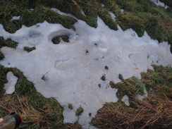
| Weather | The recent cold blast (the so-called 'Beast from the 'East') ended two days ago and whilst the snow near my home had mostly gone, I was fering flooding and showdrifts. Fortunately this did not turn out to be the case, and the day was relatively warm, with a slight (but chilly) breeze and significant sunny patches. |
| OS map | Landranger number 143 (Ely & Wisbech, Downham Market) and Landranger number 154 (Cambridge & Newmarket, Saffron Walden) |
 |
 |
|
Map of the walk
Maps courtesy of Google Maps. Route for indicative purposes only, and may have been plotted after the walk. Please let me have comments on what you think of this new format. For a detailed table of timings for this walk, please see the table file.
 |
 |
|
Notes
This should have been an easy walk to plan - the next leg of the Ouse Valley Way is a simple 15-mile stroll following the River Ouse to Ely. Unfortunately Sencan was not available to drive me to the start in Earith, where I had finished a previous walk along the Ouse Valley Way last November, although it feels much longer ago. Unfortunately public transport in the area is sparse, and to get back to Earith from Ely I would have to make a very roundabout journey, from Ely down to Cambridge by train, then the guided bus to St Ives, and finally a bus to Earith. The latter only runs a few times a day, making the whole affair seem a big hassle.
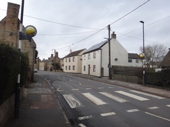
Instead, I decided to park in Earith, and walk the nine miles east along the river to the A10. Once there, I would head back by the same route. I really dislike these there-and-back walks, preferring to do circular walks where possible as you get to see different terrain. However I could not find a suitable circular walk on the map that would also allow a convenient walk to Ely in the next trip. As it is getting light earlier in the morning now, I set off for the half-hour drive to Earith at six, just as dawn was breaking. There was only two spaces free in the small car park behind the village hall, which surprised me as more spaces had been free when I had ended the previous walk there. The explanation soon came as people came to take their cars - evidently the locals use it for overnight parking. I pulled on my boots and gaiters, and headed off on the road through the village.
I had done the first part of this walk at the end of November's walk, and I strode on beside the road, which was busy with morning traffic. There had been heavy snow in the previous week, the so-called 'Beast from the East', which had sadly had led to a family party in Derbyshire being canceled. I was slightly concerned that the low-lying segment of land between the Old and New Bedford Rivers might be flooded by the snowmelt. These arrow-straight rivers are part of the historic schemes to drain the fens, and provide the waters of the Great Ouse a quicker route to the sea. They merge with the Great Ouse once more at Denver Sluice, which I will be seeing within a couple of walks.
The Old Bedford River was finished in 1636, and was followed twenty years later by the New Bedford River. The Civil War intervened, and the importance of the bridge over the new river was shown by some impressive earthworks nearby - the Earith Bulwark, which I sadly could not make out from either bridge. The area between the rivers is allowed to flood after periods of excess rain, essentially converting the area into a storage lake. The A1123 from Earith runs along the southern end of the rivers, and can be closed during floods.
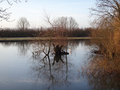
Fortunately the rivers were not high, and most of the snow had disappeared in only a couple of days, leaving a few dirty patches and a flooded field to my left that was impressively icy. The only problem was a small depression that was filled with water, but the ice was so hard I could just walk across. This led me to the bridge over the Bedford New River, after which I had to cross the road - a difficult and somewhat dangerous task given the heavy traffic.
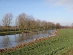
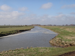
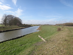
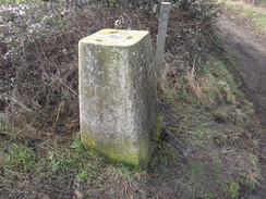
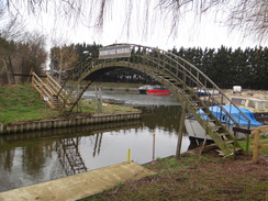
A path led from a road towards the Hermitage Marina, where a rather rickety-looking arch bridge took me over the access canal. The treads were slippery, and the balustrade felt rather too low. There was a concrete circle nearby, at the centre of which a stainless-steel pin stuck out - the remains of a pedestal for a Blacker Bombard. The trail soon left the marina and started to follow the river's northern floodbank, which I would be on for the rest of the day. In cold weather, or with a cold wind, such banks can be unpleasant places, forcing you to walk in the bank's lee, but fortunately the 'Beast from the East' which had brought us the recent cold snap had long gone.
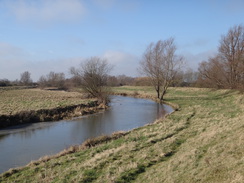
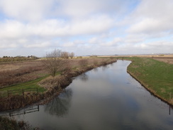
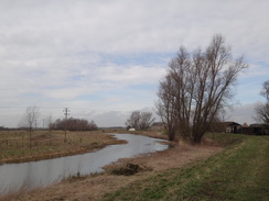
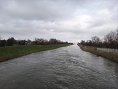
A busy road paralleled the far side of the river, and the traffic noise was loud and annoying. The road curved away towards Willingham after a while, leaving me alone beside the Great Ouse. At least, it is not quite the Great Ouse. As most of the river's water now travels via the Bedford rivers, this stretch of narrower and older river, its original course, is called the 'Old West River'. For some reason the name makes me thing of America's Deep South (perhaps because of 'Old Man River'). Like many of the rivers in the area (including the Nene, which I hope to walk soon), the river's course has changed many times over the years as man has drained the surrounding rich land.
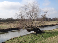
Soon I came across a place where my rather ancient map showed a bridge carrying a footpath across the river. This bridge, Flat Bridge, was missing, and a large timber that had run along its middle looked as though it had been recently cut. A glance at a more recent map online shows no footpath, so evidently that had been closed, and webpages indicate that the bridge was disheveled and rickety many years ago. I wondered if the bridge will ever be rebuilt - it appears to not really serve any habitation on either side, and there is another bridge a couple of miles away. In fact I can only find a couple of pictures of the bridge on the web - one from a boat, and the other along the top. It seems it was rather ill-regarded even when it was standing.
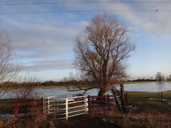
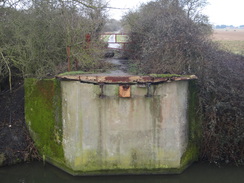
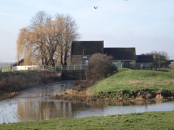
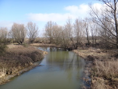
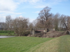
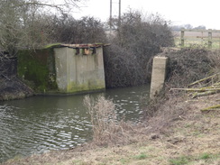
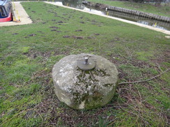
The floodbanking took me on to Haddenham Engine, a pumping station that helps drain the Aldreth area. Further on there was another notable feature: a bridge over the river, this one thankfully more intact than Flat Bridge. The bridge is currently in the middle of nowhere, but once would have been much busier as it is on the route of the Aldreth Causeway. In Medieval times this was the main route between Cambridge and Ely, and was one of only three causeways onto the Isle of Ely across the then-marshy Fens. It was also the route that the Monks of Ely used to betray Hereward the Wake during his stand on Ely against the Norman forces of William I, when they led the king's forces across to the Isle. A trig pillar near the bridge was half-buried in the bank, an indication of how the banks have been raised since it was made.
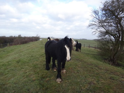
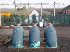
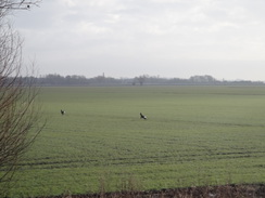
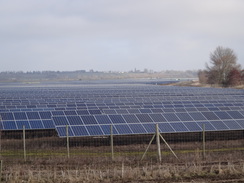
My approach alarmed two deer, who scampered quickly away across the field to my left, their white tails bobbing up and down as they ran. Some horses on the floodbank turned out to be more friendly - perhaps too much so, as they followed me for a hundred meters along the bank. As I turned a curve in the floodbanking a few miles later, I saw an off-white expanse ahead and to my left, inland of the river. It looked just like an expanse of water, but as I got closer I discovered that it was actually a massive solar farm. This is the Mingay solar farm, and although the area of land occupied by the panels is quite narrow, the glimmering panels stretched inland as far as I could see. It was an impressive sight, perhaps more so than the many tall wind turbines that have sprung up over the Fens during the last two decades.
Every so often I would come across shells lying on the grassy path; sometimes broken, but mostly whole, all exhibiting the muddy-greys and browns of the river. I guess these were fetched from the water and dropped here by birds in order to break them open; I find it hard to work out any other reason for them to be so many over such a long distance.
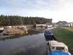
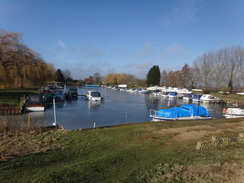
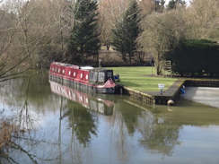
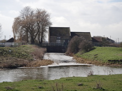
The floodbanking ended at the Twenty-Pence road, and shortly afterwards the trail diverted around the 'new' marina on the eastern side of the road. Like the river alongside, much of the marina was iced over despite the rapid thaw, and smoke swirling from boat's chimneys were the only sign of life. I pressed on, and soon the noise of the A10 intruded ahead. I reached the road, and carefully crossed it before heading up along an access road to the point where the trail rejoined the banking, this time along the south side of the river.
According to patienceafloat, the A10 between Cambridge and Ely was part of the Roman Akeman Street, which ran between Cambridge and Brancaster, on the north Norfolk coast. It fell out of favour in medieval times, when the Aldreth Causeway was more popular. A ferry took people across the Great Ouse here until 1763, and this bridge was replaced in 1976 when the A10 was straightened. This explains why there are two bridges so close together, and I wonder if the old bridge will be reused if the A10 is dualled south of Ely.
I had a decision to make here; I could easily walk on to Ely and then to Littleport, leaving me one walk (albeit a long one) to get to the end of the trail in King's Lynn. I had rejected this option as the public transport back to Earith was difficult, and a taxi from Ely would have cost forty or fifty pounds. It was tempting to continue on, and I walked up as far as the Lazy Otter pub (closed at this time of day), before deciding to stick to my original plan to head back the way I had come. So I turned around and started back towards the A10.
It felt odd to have been walking alongside the river for so long, especially after the last walk from Buckingham near the river's source, where the trail spent most of the time far away from its river. It also feels strange that the river here is relatively narrow, for the reasons given earlier. On this section the trail hugs the river like a long-lost friend, one that it will soon lose to the great expanse of the sea.
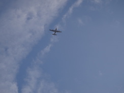
As is often the case, the return journey seemed to fly by, but it was also fairly boring. The skimming of ice on the river was noticeable thinner, much of it having melted in the few hours between my passing, and there was also less snow on the shadowed sides of ditches. I reckon by tomorrow there will be little snow or ice left. By the time I reached the Aldreth Causeway my feet were tired, and as I had plenty of time I decided to cross the bridge to take some photographs. A bench sat on the other side of the bridge, and it seemed like a good opportunity to take a little rest - which I think is the first mid-walk rest I've taken since I restarted walks for this website late last year. It was a pleasant place to stop, and I watched a large four-engined military plane fly long loops in the sky to the east, just as it had for the last few hours. I tried to imagine King William's men crossing the river (which would have been much wider back then) on the way to attack Hereward on Ely, and how they might have reacted to the sight of such a plane.
Eventually I set off once again. My feet were still a little sore, and I decided to take my time. As I neared Earith a delta-wing fast jet - probably a Typhoon - flashed overhead, it's screech cutting the air. As they often travel in pairs I searched in vain for its twin, but it appeared to be alone. Soon I was crossing the boatyard's bridge once more, and then crossing between the rivers to reach Earith and my car. It had been a slightly annoying walk - I would have preferred to press on past Ely rather than have to return - but it had been enjoyable nonetheless. The Fens are not seen as classic walking territory, but Fenland walks can be very rewarding.
 |
 |
|
Directions
General note: the directions for this walk are very easy: just join the floodbanking and keep the Great Ouse on the right until you reach the bridge carrying the A10 over the river. There are many gates and stiles to be crossed on the floodbank; as they are navigationally unimportant I have mostly omitted them from the directions below.
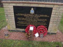
This leg starts off at the small car park behind the village hall in Earith at TL38467477, which is a few yards to the east of the junction with the B1050. Leave the car park and turn right to head east along the A1123. Pass the Crown pub on the right, and use a pedestrian crossing just before the village shop to cross to the northern side of the road. Head past Bridge End road and continue on to a bridge over the Old Bedford River. Cross this and pass a little garden that contains a memorial to two planes that crashed nearby during the war. Shortly after this, a clappergate on the left leads to a path that runs alongside the road between a fence and a ditch - a much safer alternative to walking along the road. After a fifth of a mile the path curves to the right to reach another clapper gate that leads out to a small car park beside the bridge over the New Bedford River at TL39317473.
Note that the path alongside the road between the rivers may flood after high rain; the road itself may close after particularly heavy rain. In such conditions, please check the web to discover the road's current status.
Cross the bridge to immediately reach a roundabout with the B1050, which comes in from the right. At the roundabout, carefully cross the A1123 to reach the southern side of the road and follow the B1050 south towards Hermitage Lock and a bridge over the river. However after about ten metres, and before the bridge is reached, carefully cross the B1050 to reach the other (eastern) side. Head through a gap in a wooden fence to join a path that runs between fences to reach some wooden steps that lead down to the base of an arched footbridge over a marina entrance.
Cross the bridge, and climb wooden steps on the other side before heading across a short expanse of grass to reach a clappergate that leads out onto onto a floodbank, with the river away to the right. Initially the A1123 parallels the other side of the river, although this curves away from the river after a mile. Continue along the flood bank, crossing any stiles or gates on the way; after 1.8 miles it reaches a track called Flat Road at TL41787293. Note that the bridge over the river that used to be here is currently missing (March 2018).
Continue on along the floodbank. After two-thirds of a mile Haddenham pumping station is reached on the left. Continue along the floodbank with the river on the right; after another 0.8 miles High Bridge is reached over the river at TL43837217. This bridge carries the ancient Aldreth Causeway route across the river. Do not cross it.
Instead, cross the track, climb back onto the floodbank, and follow it as it twists and turns with the river away to the right. After 3.3 miles the floodbank squeezes between a hedge and cottage on the left and the river on the right; a few metres past the cottage, join a driveway that leads out onto the B1049 Twenty Pence Road at TL47967117.
Turn left down the road for a few metres, and then right through a metal field gate to rejoin the floodbank. This runs behind houses and soon curves to the left to head around the Twenty Pence Marina. Cross a track over the floodbank, and continue along the floodbank as it runs around the marina, before it curves to the left once more to leave the marina. 1.2 miles after the marina, go through a wooden clapper gate and climb up a bank to reach a safety barrier. Cross the barrier to reach the A10 road at TL50017178.
Very carefully cross the busy road, and then turn right to start following the verge southwards, with the road to the right. The road immediately crosses the bridge over the river; when a road leads off to the left after a couple of hundred metres, turn left to follow it for a third of a mile to the Stretham Ferry road bridge over the river at TL50137215. Cross this, and continue on for a hundred metres until the Lazy Otter Inn is reached on the right at TL50147222.
The rest of the directions for the walk are easy; just reverse those mentioned above. However, for people walking the route in reverse, here they are:
Leave the Lazy Otter pub and turn left to walk south along the road, soon crossing the Stretham Ferry road bridge over the river. Continue on for a third of a mile until the road curves to the right to end at a T-junction with the A10. Turn right to follow the roadside verge northwards; when there is a safe opportunity, cross the road to the other side, and head on with the road on the right. Cross a bridge over the river and, immediately on the other side, climb over the safety barrier and descend a bank to reach a wooden clappergate at TL50017178.
Go through this and start following the floodbank, with the river away to the left. After 1.2 miles the floodbank curves to the right to start passing the Twenty Pence marina on the left. The bank curves left to head along the northern side of the marina, and then left once more to cross a track that climbs the bank. A few yards further on the bank turns right to rejoin the river; it squeezes between the river on the left and houses on the right, before reaching a field gate that leads onto a road at TL47967117 - in March 2018 this gate was locked, meaning you either have to climb over or squeeze past it.
Turn left along the road for a few yards towards the river bridge, and then turn right along a track that leads towards a cottage. As the track dips down to the right, turn left to head straight on along the flood bank, passing a cottage on the right. Follow the floodbank in a rough westerly direction for 3.3 miles until High Bridge over the river is reached on the right at TL43837217. This bridge carries the ancient Aldreth Causeway route across the river.
Descend the bank by a trig pillar and cross a track, before climbing up the floodbank on the other side of the track. Continue along the floodbank for 0.8 miles until Haddenham Engine is reached on the right. Pass the buildings and continue on for another two-thirds of a mile until the remains of Flat Bridge is reached at TL41787293; the bridge over the river is currently missing (March 2018).
Continue northwestwards along the floodbank; the B1050 road joins the far side of the river. After 1.8 miles go through a clappergate to enter Hermitage Marina. Walk across grass towards an arched footbridge; descend some wooden steps to reach the bridge, cross it, and then climb up some wooden steps on the other side. Continue on between fences to reach a wooden fence ahead; squeeze through a gap to reach the B1050 road at TL36357469.
Carefully cross the B1050, and turn right to follow it for a few yards to a roundabout with the A1123. At the roundabout carefully cross the A1123 ahead, and then turn left to cross the bridge over the New Bedford River. On the other (western) side, turn right into a little car park and head across to a clapper gate that leads to a path. Follow this path as it parallels the road, with a ditch to the left and a fence to the right. After a fifth of a mile another clappergate leads back out onto the B1050 road.
Turn right and walk along the verge to the bridge over the Old Bedford River. Cross this, and on the other side continue on into Earith. This walk ends a quarter of a mile from the bridge at the car park behind the village hall at TL38467477, which is shortly after the Crown pub is passed and just before the B1050 road comes in from the right.
 |
 |
|
Distances
| From | To | Distance (m) | Ascent (ft) | Descent (ft) |
|---|---|---|---|---|
| Earith | Stretham Ferry Bridge | 9.4 | 13 | 36 |
| Stretham Ferry Bridge | Earith | 9.4 | 36 | 13 |
This makes a total distance of 18.8 miles, with 49 feet of ascent and 49 feet of descent.
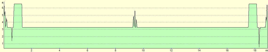
For more information on profiles, ascents and descents, see this page
 |
 |
|
 |
 |
|
 |
 |
|
 |
 |
|
 |
 |
|
 |
 |
|
 |
 |
|
 |
 |
|
 |
 |
|
 |
 |
|
 |
 |
|
 |
 |
|
 |
 |
|
Disclaimer
Please note that I take no responsibility for anything that may happen when following these directions. If you intend to follow this route, then please use the relevant maps and check the route out before you go out. As always when walking, use common sense and you should be fine.
If you find any information on any of these routes that is inaccurate, or you wish to add anything, then please email me.
All images on this site are © of the author. Any reproduction, retransmissions, or republication of all or part of any document found on this site is expressly prohibited, unless the author has explicitly granted its prior written consent to so reproduce, retransmit, or republish the material. All other rights reserved.
Although this site includes links providing convenient direct access to other Internet sites, I do not endorse, approve, certify or make warranties or representations as to the accuracy of the information on these sites.
And finally, enjoy your walking!
Nearby walks
| # | Title | Walk length (miles) |
|---|---|---|
| 2 | Waterbeach to Newmarket Road, Cambridge | 5.4 |
| 5 | A short walk around Waterbeach to Car Dyke | 3.0 |
| 6 | Waterbeach to Newmarket Road, Cambridge | 5.4 |
|
|

|