Walk #985: Ouse Valley Way: Stretham to Littleport
 |
 |
|
General Data
| Date Walked | 09/03/2018 |
| County | Cambridgeshire |
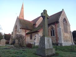
| Start Location | Stretham Church |
| End Location | Littleport Station |
| Start time | 06.40 |
| End time | 12.11 |
| Distance | 15.7 miles |
| Description | This was a pleasant walk, mostly following the Ouse Valley Way across the Fens. |
| Pack | Today I carried my 30-litre Karrimor rucksack, filled with water, my waterproofs, a book and other odds and ends. |
| Condition | My feet feel slightly tired after this walk, but aside from that I feel absoltuely fine. |
| Weather | The day started off sunny and a little chilly, but as the day progressed the cloud gathered and it warmed up considerably. It was a perfect spring day for a walk. |
| OS map | Landranger number 154 (Cambridge & Newmarket, Saffron Walden) |
 |
 |
|
Map of the walk
Maps courtesy of Google Maps. Route for indicative purposes only, and may have been plotted after the walk. Please let me have comments on what you think of this new format. For a detailed table of timings for this walk, please see the table file.
 |
 |
|
Notes
My last stroll along the Ouse Valley Way left me at the Stretham Ferry Bridge, beside the A10 between Cambridge and Ely. This has no bus service, but regular buses do call at the village of Stretham, a mile or so to the north. I therefore drove to Ely, parked in a convenient long-stay car park and walked to the bus stop at the large Tesco store. I had a few minutes to spare, so I nipped in to buy a few snacks, before heading back and waiting for my bus. This dropped me off in Stretham, where I nipped into the local shop before starting my walk.
A dear friend of ours used to live in Stretham, and I took a little diversion to pass the cottage he used to live in. I have always liked the village, and it is sad that it now has some rather negative memories. I put this to the back of my mind and carefully crossed a busy road before heading down a minor road that led south into the Fens. It had been cold overnight, and I had to walk along the raised middle of the road rather than the tyre tracks, which were slippery with ice.
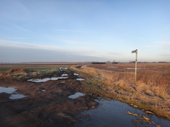
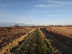
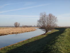
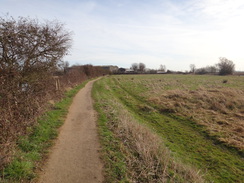
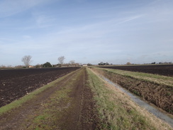
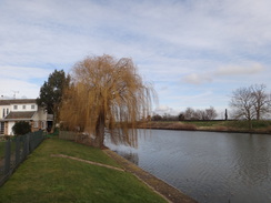
Walking in the Fens may not be in everybody's tastes, but I quite enjoy it. You get very wide vistas, and it sometimes feels lie the highest things in the world are the treetops. Whatever else it may be, it is rarely boring. There are frequent 360-degree vistas, with the highest thing visible being the tops of distant trees. It is open, expansive walking; as different to hillwalking as you cann get, but with its own joys.
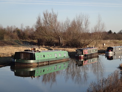
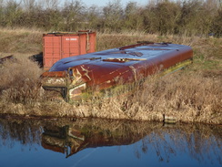
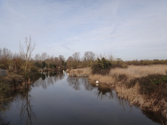
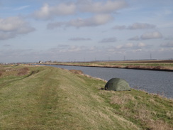
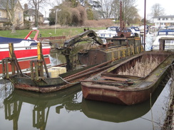
The road led to a bridge over the river, and instead of crossing it to join the trail, I headed along the floodbank on the northern side. This carries the Rothschild Way, another trail that is on my todo-list. The ground was not muddy and I made good time, and I was soon squeezing past holiday homes and the Lazy Otter Inn. The floodbank ended in front of an incongruous gate in a fence that led onto a road immediately by Stretham Ferry Bridge. This marked the point I had turned back on my last walk, and after crossing the bridge I joined the trail by heading along the southern floodbank. Boats were moored by the river, including an odd mottled brown one in the distance. As I approached I discovered it was actually the upturned hull of a broad barge, with a similar-coloured container behind. Given the inaccessible location, they must have had a hard job lifting it out of the water.
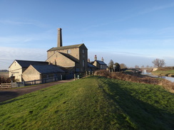
The next couple of miles proved to be an enjoyable stroll. The sun gleamed off the water, which due to the lack of wind was as still as a millpond. A solar farm in a field gathered early-morning rays, and soon I was back at the bridge over the river I had reached earlier. A little further on was Stretham Old Engine, the last survivor of over a hundred steam engines that once worked to drain the Fens. Built in 1831, it now operates on select days using diesel power. It has been on my to-visit list for years, and I shall have to bring Robert here when he is a little older.
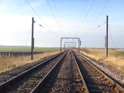
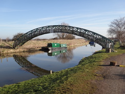
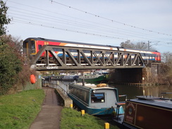
The floodbank continued to the A1123 road, and on the other side to a bridge that carries the Cambridge to Ely railway line over the river. There seem to be two routes to cross the line - a gated crossing and an underpass. I chose the former, although a sign on a gate indicated that it may soon be closed. If so, the only alternative might be the route under the bridge, which may be impassable in floods. I hope any closure does not affect the trail too badly. An arched footbridge over the river became visible a little further on; it is an old friend that I have walked over many times before. It spans the Great Ouse just upstream of its confluence with the Cam; I remember when this bridge was new, built to avoid the need to cross the river at the railway bridge. The bridge also marked the end of the Ouse Valley Way for me, as I have walked the thirty miles north to the trailhead at King's Lynn many times before along the Fen Rivers Way, which from here to the sea is mostly coincident with the Ouse's trail.
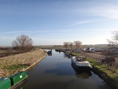
I crossed the bridge and headed along the wider river. It has always felt to me as though the combined river should really be the Cam rather than the Great Ouse; the latter (in its Old West River form) is smaller and seems to join the former. Whatever its name, it is an old friend. Twenty years ago I had the last in a series of operations on my ankle, and the stretch between Waterbeach and Ely was the first long-distance walk I did afterwards. I have done it many times since, and it can probably be blamed for the many walks I have done since.
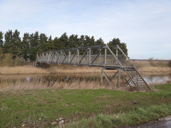
The river heads north, passing a landing stage at Little Thetford before reaching an inlet called Braham Dock. The trail used to head along the drain's southern bank, crossing the end of it on a perilously narrow strip of land between the water and the fence guarding the railway line, before heading back to the river along the northern bank. A few years back a large metal footbridge was built over the mouth of the drain, and this seems a much better and safer way across. However the 1:25,000 map seems to indicate the Fen Rivers Way taking the old route, so I decided to take a look. However the narrow strip of land beside the railway was heavily overgrown and impassable, so I headed back to the bridge and crossed that. A stile had been removed from a fence on the other side, which is another indication that the old route is now abandoned, whatever the map says.
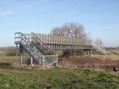
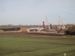
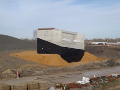
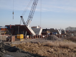
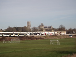
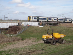
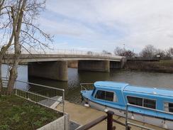
Ely Cathedral was clearly visible ahead, and from this angle it truly lives up to its name of 'The Ship of the Fens'. The trail crosses the Ely to Newmarket railway line, with an adjacent river bridge which is a relatively new structure after the old one was destroyed during a freight train derailment in 2007. A little further on I passed some works for the new Ely southern bypass, which is due to open later in the year. Not much progress appears to have been made since I walked this stretch a couple of months ago, although at least four long bridge beams were on site. Some men in a scissor hoist were helping remove some shuttering from a concrete bridge support, and others were busying themselves around the site. It'll be interesting to see how the final bridge looks and if, as some fear, it interferes with views of the cathedral, despite the viewing platform that will be built mid-river.
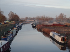
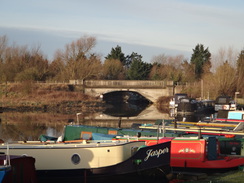
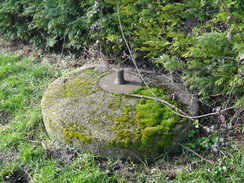
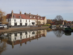
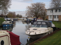
The path passed Ely station to the left before reaching a road. Here two young men asked me if this was the Fen Rivers Way; they were on their way to Cambridge, and I wished them luck before starting along another familiar stretch of path. This follows the river through Ely, immediately passing another pedestal for a Blacker Bombard (similar to the one I saw near Earith on the last walk) and heading under a railway bridge to reach Ely waterfront. The waterfront is always a treat, but today was not a day for dawdling and I pressed on past the boats and pubs.
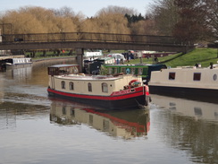
I tried to keep pace with a narrowboat that was going downstream, but it soon pulled ahead of me, and went out of sight as the trail diverted inland to pass a factory and head across the Cuckoo Bridge. A fence to the left guarded an industrial site, part of which is now used to store railway carriages. Shortly afterwards a rather industrial-looking bridge crossed the river, carrying three trails: the Ouse Valley Way, the Fen Rivers Way, and the Herewards Way. On the other side of the bridge, the Fen Rivers Way heads north along the floodbank beside a rather busy road. From the map it appears the Ouse Valley Way makes a little diversion that might well be safer, so I followed that instead. Initially this followed the Hereward Way's route past a large bank that holds back a reservoir, before striking north across black Fenland fields to meet the B1382 road.
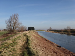
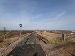
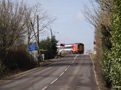
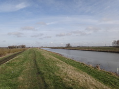
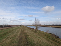
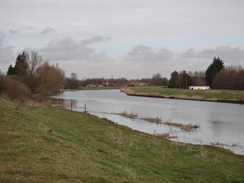
This road has four railway level crossing in a short distance, and as I approached the first, which carries the Ely to Norwich line over the road. A train passed before I reached it, but the barriers came down just as I arrived. I waited, hoping to photograph a train, but after a few minutes the barriers rose again without a train having passed. Network Rail are considering closing some of the crossing on this road, an act which would cause massive inconvenience for the locals as alternative routes are very long. Shortly afterwards the road crossed Queen Adelaide Bridge over the river, and the trail rejoined the Fen Rivers Way. What followed was a long walk along flood banks; in the past this has been rather overgrown, but it was clear today and made for a very pleasant walk.
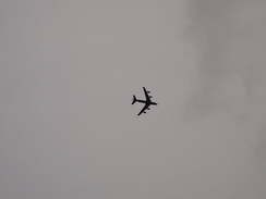
For the last couple of hours I had heard the sound of fast jets ripping the air, and occasionally dart shapes flashed past in the distance. A lower hum came from behind, and I looked up to see a large cargo aircraft flying east. A similar plane - or perhaps the same one - flew past a few minutes later. This area's airspace is certainly very busy, perhaps a result of theAmaerican airbases to the east at Mildenhall and Lakenheath.
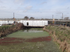
The miles along the floodbank should perhaps have been boring, but there was enough to see as I walked. The railway to my left was lower than the floodbank, and the surrounding land was even lower, and well below the level of the river. A Network Rail van slid and slipped as it went up a track on the other side of the line, and the grass beside the floodbank had been slightly chewed up by vehicles. A rail bridge, part clad in plastic sheeting, explained the reason: the line had been closed in mid-February to allow engineers to strengthen the bridge, and the expanse of grass below the bank had evidently been used as an access route. I chatted to a workman who appears to be installing a clappergate beside the bridge, who was a fellow walker.
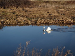
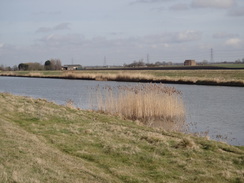
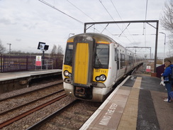
No boats passed by on the water, and the swans seemed unfussed by the solitary fisherman who had several rods dipping into the water. Eventually the open floodbank became constrained by fences, and the path then started heading through a series of gardens, many of which had small gates to negotiate. I had purposefully not checked train times before I set off, and as I checked on my mobile I could see a train was due in half an hour. I sped up, ignoring the pub that was due to open in a few minutes, and charged along the floodbank. After passing a little marina I approached a signal box and arrived at the station with five minutes to spare. The ticket machine was under repair, and I could not find how to get to the opposite platform; eventually I found a barrow crossing at the far end. When I got onto the platform I chatted to a local man who will soon be moving from an area that he referred to as 'a sh*thole', a classification he also included Ely in. Somewhat unfairly, in my view.
Two refueling planes flew low overhead as I walked back to my car in Ely, and I arrived home just after one in the afternoon. It had been a pleasant walk, but I'm left in a little quandary about what to do next: it is 24 miles to the end of the trail in King's Lynn, which I could do in one walk (as, in fact, I have done before), or as 18 miles to Watlington and then six miles on another walk. Hopefully I do not have to wait too long before I have to choose.
 |
 |
|
Directions
This walk starts off outside the church in Stretham, which is a few miles to the south of Ely, at TL51227461. I took a slightly different route through the village, but the easiest route is to start with the church on your right and the Red Lion pub on the left, and to walk south down the High Street for a short distance until it ends at a T-junction with the A1123 Wilburton Road. Carefully cross the road to reach the pavement on the other side, and turn left to follow the road eastwards. After 100 metres, turn right down Green End. Follow this road as it heads southwards; after nearly a mile it starts climbing to reach a bridge over the Great Ouse at TL51507297.
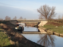
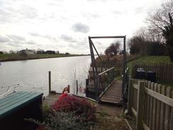
Just before the bridge is reached, turn right down a short track that soon leads to the floodbank. Follow a path along the top of the bank, initially passing boat moorings, going through any gates you reach on the way. After 0.9 miles the path goes through a clappergate and starts following a fence on the right, beyond which are holiday homes. Continue along the path on top of the floodbank as it curves to the left in front of the Lazy Otter pub; it crosses a paved path that heads up steps from the floodplain to the pub, and then passes between a tree and a bush before curving to the right. Climb a slight slope to reach a gate in a fence that leads out onto the Stretham Ferry Road. Turn left to reach Stretham Ferry Bridge over the river at TL50137215.
Note: as most of this walk just follows floodbanks, I only mention stiles or gates when they are navigationally useful.
Cross the bridge, and when the road curves slightly to the right after a few yards, turn left to join a floodbank that carries the Ouse Valley Way, which will be followed for the rest of the day. The path passes a solar farm on the right. After a mile go through a gap in a wooden fence and angle right to join a road that soon leads to a bridge over the river on the left at TL51527294.
Continue straight on along a road called Green End for about 300 metres, passing Stretham Old Engine on the right. Just before a flood barrier in the road is reached (and before the road turns right), turn left up three steps onto the floodbank and then turn right to join a footpath that runs along the top of a floodbank. After a little under half a mile the path goes through a metal clapper gate to reach the A1123 road at TL52137355.
Carefully cross the road and a crash barrier on the other side to rejoin the path on top of the floodbank. After three-quarters of a mile the bank and river curve to the right to reach the Cambridge to Ely railway line. At the moment (March 2018) you can use a crossing to carefully cross the line, but when this closes you will have to head under the railway bridge using a new path.
Continue along the top of the floodbank for a couple of hundred meters until a track is reached beside a marina at Pope's Corner. Turn half-left down this track, descending off the floodbank to reach an arched footbridge that spans the river by the confluence with the River Cam at TL53417453. From here on north, the trail mostly follows the Fen Rivers Way as well as the Ouse Valley Way.
Cross the bridge, climbs steps up onto the floodbank on the other side, and then turn right to continue on northwards along the western bank of the river. Pass the moorings at Little Thetford and head on. Nearly two miles north of Pope's Corner a little inlet called Braham Dock is reached; cross this using a large metal footbridge and then continue north along the floodbank.
The Ely to Bury St Edmunds railway line is reached after another half-mile. Go through a gate and cross the line with care; on the other side go through another gate to rejoin the floodbank. A short distance further on the new bridge carrying the Ely Southern bypass over the river is reached. Pass under this (or pass the works if it is not yet open), and continue on for two-thirds of a mile until a clapper gate is reached. Go through this, or under the vehicle barrier alongside, to reach the A142 road in Ely at TL54477933. The railway station lies a hundred metres away to the left.
Cross the road, turn right for a couple of metres and then left to join a riverside path. The path soon crosses a bridge over the entrance to a marina before diving under a railway bridge. It then crosses a small bridge over the entrance to a boatyard before curving to the right to pass in front of the Cutter Inn and the Jubilee Gardens to reach the Maltings. Shortly after passing the Maltings, the path joins the side of a road called Ship Lane, which curves left away from the river.
After a few metres it reaches a complex junction with the end of an inlet to the right; here turn right down a short track towards a footbridge over the river ahead. Do not cross the footbridge, but just before it is reached turn left to join a path called 'Pegasus Walk'. Initially this squeezes between a building on the left and the river on the right, before turning left and then right to enter a grassy area.
The path crosses the grassy area with the river to the right; it then meets a road that curves in from the left. As the road continues curving left into a car park, turn half-right to follow the path as it passed under a railway bridge. On the other side, go through a clappergate and continue along the path as it follows the river bank; after a while the river slowly curves away to the right and the path continues straight on, following a hedge on the left with a field to the right. Half a mile after the railway bridge, the path reaches a factory ahead at TL55658045.
Go through a gate and turn left to follow a footpath that runs north for a short distance with a hedge on the left and the factory on the right; this soon ends at a T-junction with a track called Kiln Lane. The next few hundred metres carry three long-distance trails: as well as the Ouse Valley Way, it also carries the Fen Rivers Way, the Hereward Way.
Turn right and follow Kiln Lane as it heads east past the factory. At the end of the factory's yard, go past a large metal pallisade gate to join a path that follows a short stretch of palisade fencing on the left; as the track curves right, turn left to continue straight on along a footpath that soon reaches a footbridge called Cuckoo Bridge. Soon after the bridge the path jinks to the right, following a fence on the left, and then to the left to rejoin the riverbank. Head northeastwards for a few metres to reach a metal footbridge over the Great Ouse at TL56128051. Use the bridge to cross over to the eastern bank of the river, and then climb up onto the road. The Fen Rivers Way is now left for the next couple of miles.
Carefully cross the road and turn right to follow it south-southwestwards; care is needed as the traffic can be quite fast. Just before the road curves to the right after 200 metres, turn left down a track that descends to the base of a grassy bank on the left. Follow this track east-northeastwards; two-thirds of a mile after leaving the road, and shortly after the bank ends, turn left past a metal barrier to join a footpath that follows a ditch on the right, whilst the Hereward Way continues straight on. The path soon curves to the right to take a more northerly course, and after a third of a mile it passes a barn on the left to reach the B1382 road at TL56948147. Turn left to follow this road westwards; it crosses a level crossing over a railway line, and a pavement then starts on the right-hand side of the road. After a fifth of a mile reaches the Queen Adelaide Bridge over the Great Ouse at TL56548146, where the route of the Fen Rivers Way is rejoined.
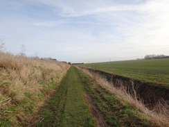
Use the bridge to cross the river and descend down the other side. At the end of the bridge's approach ramp, turn hard right to walk back alongside the road, past a house on the left, to reach a clapper gate beside a field gate. Go through this and climb up onto the top of the floodbank, and then turn left to follow it north, with the river on the right. Continue on northwards for a little over three miles, on a couple of occasions diverting to the left off the floodbank to reach clapper gates guarding inlets.
Eventually a clappergate is reached through a fence at TL57538593, with a static caravan site off to the left. Continue along the floodbank past the site, and at its northern end go through a pedestrian gate. After this the path curves to the right down the bank, and then left up three steps to reach a small footbridge over an inlet. A series of other small gates follow as the path passes through a series of gardens belonging to houses as it heads towards Sandhills road bridge ahead. Immediately before the bridge, the path turns to the left for a short distance to reach a pedestrian gate beside a field gate that lead out onto a road on the eastern outskirts of Littleport. Turn right along the road for a few metres until it ends at a T-junction at TL576864, with Sandhills Bridge a few metres away to the right, a level crossing to the left, and the Swan on the River pub in Littleport directly opposite.
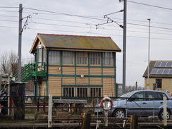
Cross the road and head through the pub's car park. At the far end cross a stile beside two field gates and climb up onto the floodbank, where a footpath heads north with the railway line close by to the left; as the railway line curves to the left, the path goes straight on alongside the river bank. Cross a stile and continue on with the river on the right. The path becomes a track; cross a stile beside a farm gate and head on, passing a house on the left. The path then curves to the left, and then fully left to squeeze past a gate. The path passes between two fences to reach another gate. On the other side turn left along a track with Littleport Boat Haven on the right. At the end turn right to pass a railway signal box on the left to reach Station Road at TL57478735.
Here the Ouse Valley Way turns right along the road; to reach the station, turn left across the level crossing and immediately right up the station approach road. To get to the southbound platform (for Ely, Cambridge and London), climb up the steps or ramp onto the platform, turn left to walk to its northern end, and use the barrow crossing to cross over to the other platform.
 |
 |
|
Distances
| From | To | Distance (m) | Ascent (ft) | Descent (ft) |
|---|---|---|---|---|
| Stretham church | Stretham Ferry bridge | 2.4 | 3 | 39 |
| Stretham Ferry bridge | Holt Fen bridge | 2.7 | 0 | 3 |
| Holt Fen bridge | Ely | 3.5 | 3 | 0 |
| Ely | Queen Adelaide Bridge | 3.1 | 0 | 0 |
| Queen Adelaide Bridge | Littleport station | 4.0 | 16 | 20 |
This makes a total distance of 15.7 miles, with 22 feet of ascent and 62 feet of descent.
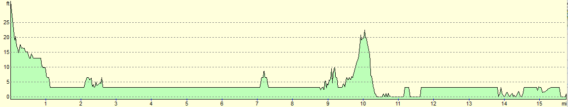
For more information on profiles, ascents and descents, see this page
Transport
The 9 and X9 bus services run regularly from Ely (either the centre of town or the large Tesco store)to Cambridge, calling at Stretham church on the way. To get back to Ely, regular hourly services run from Littleport station to Ely station.
 |
 |
|
 |
 |
|
 |
 |
|
 |
 |
|
 |
 |
|
 |
 |
|
 |
 |
|
 |
 |
|
 |
 |
|
 |
 |
|
 |
 |
|
 |
 |
|
 |
 |
|
 |
 |
|
 |
 |
|
 |
 |
|
 |
 |
|
 |
 |
|
 |
 |
|
Disclaimer
Please note that I take no responsibility for anything that may happen when following these directions. If you intend to follow this route, then please use the relevant maps and check the route out before you go out. As always when walking, use common sense and you should be fine.
If you find any information on any of these routes that is inaccurate, or you wish to add anything, then please email me.
All images on this site are © of the author. Any reproduction, retransmissions, or republication of all or part of any document found on this site is expressly prohibited, unless the author has explicitly granted its prior written consent to so reproduce, retransmit, or republish the material. All other rights reserved.
Although this site includes links providing convenient direct access to other Internet sites, I do not endorse, approve, certify or make warranties or representations as to the accuracy of the information on these sites.
And finally, enjoy your walking!
Nearby walks
| # | Title | Walk length (miles) |
|---|---|---|
| 2 | Waterbeach to Newmarket Road, Cambridge | 5.4 |
| 3 | Littleport to Downham Market | 14.0 |
| 5 | A short walk around Waterbeach to Car Dyke | 3.0 |
|
|

|