Walk #104: Glastonbury to Wells
 |
 |
|
General Data
| Date Walked | 07/08/2000 |
| County | Somerset |
| Start Location | Glastonbury |
| End Location | Wells bus station |
| Start time | 07.10 |
| End time | 10.00 |
| Distance | 7.2 miles |
| Description | A short and boring walk between these two towns. |
| Pack | Full Pennine-Way spec kit. |
| Condition | Okay. The underside of my feet were aching throughout the walk, but they soon recovered once the walk had finished. |
| Weather | As soon as I started walking it started to drizzle, but this soon cleared up to leave a cloudy but hot day without much wind. |
| OS map | Landranger number 182 (Weston-super-Mare, Bridgwater & Wells) |
Map of the walk
Maps courtesy of Google Maps. Route for indicative purposes only, and may have been plotted after the walk. Please let me have comments on what you think of this new format. For a detailed table of timings for this walk, please see the table file.
Notes
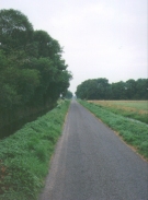
This was a fairly pleasant mornings walk between the two historic towns of Glastonbury and Wells. Unfortunately this involved crossing yet another section of the Somerset Levels, in this case Queen's Sedge Moor. Whilst I do not normally mind walking on the flat in such a manner, the straightness of the roads across the levels do mean that the walk can become slightly boring. At least with canal walking you always have the wildlife (even in the cities) that exist on the margins between land and water. Unfortunately the only wildlife that existed on Queen's Sedge Moor appeared to be cows in the fields (which seemed to like drinking out of the roadside ditches) and numerous biting insects that made sitting down for any long period unpleasant.
An early start allowed me to wrap up this short walk very quickly, which was required because the journey back to Cambridge was going to take up the rest of the day. This also allowed me to walk in the coolest part of the day, before it started getting too hot.
As soon as I walked out of the gate of the campsite a light drizzle started, which I was afraid may last all day. Fortunately by the time I had walked for about twenty minutes it stopped and I was left with a cloudy sky for the rest of the walk. By the time that I had caught the bus from Wells back to Glastonbury to get my connection to Taunton the weather had cleared and the sun was shining.
I usually feel out of place travelling back at the end of a walk because I tend to be unkempt, with grizzly hair and slightly sweaty clothes. On this occasion I felt totally at home, as half the people in Glastonbury appeared to be in the same state, and many had far weirder clothes than my walking clothes on!
This walk is fairly non-descript, consisting of road walking for nearly it's entire duration. There are some footpath based alternatives that could be used, and indeed I had planned to use them, but because they were longer and I needed to get to Wells early I decided to opt for a more direct route.
For most of the journey Glastonbury Tor was visible in the distance - it would be quite nice to walk this walk in the opposite direction and see yourself getting nearer and nearer to the Tor as you head south.
Directions
The campsite that I stayed at was the Isle of Avalon site, which is situated on the north-western side of Glastonbury in the triangle between the A39 and the B3151 at grid reference ST 493398. The directions that I give will be from that location; if walking from the centre of Glastonbury note that the A39 has a pavement running alongside it as far as Hartlake Bridge, allowing easy access to the latter stages of my route from the town itself.
Turn left out of the Isle of Avalon campsite and head north. You almost immediately come across a road junction, at which you turn right to head north-eastwards. Take the next junction to the left and head north across Common Moor. Turn right at another road junction and follow the road as it curves around to the east. Follow this road as it goes straight for nearly a mile to join the A39.
Cross the A39 to the pavement on the eastern side of the road. Head north along the road to cross the Hartlake Bridge. Shortly after the bridge a road to the right heads off to the northeast across Queen's Sedge Moor. Take this road, which is part of the West Country Way and the National Cycle Network Route three, for two to three miles until it ends at a T-junction.
Turn left at the T-junction and head along a winding road up the hill through Launcherley. Head straight across at a crossroads and head uphill. Shortly after the top of the hill the road turns to the north and heads downhill past Wellesley Farm. This route is now part of the Monarch's Way. The route crosses yet another crossroads and takes a track that heads north. The track soon finishes and the path crosses fields over a hill before joining a farm track that takes you northwards over the busy A371 road by a large farm occupation bridge.
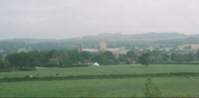
Shortly after the track descends from the bridge another track leads off to the right and the track ahead goes into a farmyard. At the junction between the two tracks a footpath heads off to the left, passing between the farm buildings and a car park. Take this footpath, which brings you out into the centre of Wells. The bus station is now within a few hundred yards, whilst the cathedral is a slight way to the northeast.
Transport
Bus services run from Wells north to Bristol and Bath, and south to Glastonbury. Other bus services run from Glastonbury south to Taunton.
Distances
| From | To | Distance (m) | Ascent (ft) | Descent (ft) |
|---|---|---|---|---|
| Glastonbury | Wells | 7.2 | 256 | 154 |
This makes a total distance of 7.2 miles, with 256 feet of ascent and 154 feet of descent.
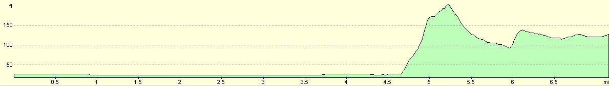
For more information on profiles, ascents and descents, see this page
Disclaimer
Please note that I take no responsibility for anything that may happen when following these directions. If you intend to follow this route, then please use the relevant maps and check the route out before you go out. As always when walking, use common sense and you should be fine.
If you find any information on any of these routes that is inaccurate, or you wish to add anything, then please email me.
All images on this site are © of the author. Any reproduction, retransmissions, or republication of all or part of any document found on this site is expressly prohibited, unless the author has explicitly granted its prior written consent to so reproduce, retransmit, or republish the material. All other rights reserved.
Although this site includes links providing convenient direct access to other Internet sites, I do not endorse, approve, certify or make warranties or representations as to the accuracy of the information on these sites.
And finally, enjoy your walking!
This walk was mentioned in the following routes:
| My sectional Land's End to John O'Groats walk |
Nearby walks
| # | Title | Walk length (miles) |
|---|---|---|
| 103 | Langport to Glastonbury | 11.3 |
| 124 | Wells to Cheddar | 11.3 |
|
|

|