Walk #143: Cheddington Station to Bletchley Station
 |
 |
|
General Data
| Date Walked | 22/07/2001 |
| County | Buckinghamshire, Bedfordshire |
| Start Location | Cheddington Station |
| End Location | Bletchley Station |
| Start time | 09.30 |
| End time | 14.41 |
| Distance | 13.3 miles |
| Description | This was a nice walk northwards along the Grand Union Canal, following the towpath for all but the first and last sections to and from the stations. |
| Pack | I carried full Pennine Way-spec gear, except for the fact I carried no spare clothes. |
| Condition | My feet started aching slightly early into this walk, but they actually felt better after I stopped for twenty minutes. The biggest problem during this walk was my bad ankle, which I went over on somewhere between Leighton Buzzard and Soulbury. I kept on walking whilst it ached but it only hurt if I went on slightly rough ground with it. I also caught a little sun on the back of my neck. |
| Weather | The weather today was a mixture of sunshine and cloud, with no sign of any rain. |
| OS map | Landranger number 165 (Aylesbury & Leighton Buzzard, Thame & Berkhamstead) |
 |
 |
|
Map of the walk
Maps courtesy of Google Maps. Route for indicative purposes only, and may have been plotted after the walk. Please let me have comments on what you think of this new format. For a detailed table of timings for this walk, please see the table file.
Notes
The last walk along the Grand Union Canal left me rather badly placed as it was cut short, with only about four miles to be done to reach Leighton Buzzard. This meant that this walk had to be rather longer than I had originally planned, with few options to walk any distance other than 4 or 13 miles due to the sparsity of railway stations along this section of canal.
The towpath was very busy with anglers, especially in the sections going up to Fenny Stratford where it looked as though there was a national angling championship going on. This meant that I had to keep on stepping over or passing under long fishing poles (indeed they were so long they could pass from one side of the canal to the other, yet were very light). According to one angler I spoke to the ;poles alone cost over two thousand pounds, which I thought was an astronomical figure. Having said that, my equipment was worth approximately that as well.
When I was driving over the railway bridge next to Cheddington Station there were two men standing on the bridge looking at the railway to the south. When I arrived at the bridge ten minutes later after parking on getting my boots on they had gone, so I assumed they were railway enthusiasts. However shortly after I git into the fields on the way to Horton Lock I saw them again, standing in the middle of the field looking at a map and using binoculars. When I reached them it turned out they were birdwatchers, doing a circular walk from Tring Station. After having a quick chat we decided to head off together.
The first stile that we reached was very overgrown, and consisted of a stile, two railway sleepers over a ditch and another stile on the other side, all obscured by the lovely combination of brambles and hawthorn branches. After a couple of minutes cursing the three of us got through safely, and proceeded down the field only to find that we were in the wrong field, so we had to climb over a fence next to a gate back into the field that we came from! There then followed ten minutes of overgrown stiles until the three of us finally got to the canal with great relief. Fortunately the only casualty of this were my trousers, which got quite badly ripped when I was hoisting my leg to get over some brambles.
Just north of Grove Lock I came across a concrete jetty between the towpath and the canal, and the towpath rose up a few feet to accommodate it. It had a couple of rails on it, I guess about eighteen inches apart. The rails curves slowly off the jetty and towards a field, but they ended before the towpath. I was quite curious about what these rails may have been, and a look in my guidebook when I got home shows that this was an old narrow-gauge railway built to bring sand and gravel for transhipment to the canal.
I had a little scare with my bad ankle near Old Linslade when I was approaching a man rebuilding a boat by the canal. I moved off the path to avoid a pile of timber and went onto the grass. Unfortunately the ground underneath the grass was uneven, and I went over on my ankle causing some considerable pain. I picked myself and gingerly set off walking again, and although it ached severely at first this pain soon subsided to a dull ache. I take this incident to be quite positive, as I still managed to complete the walk that I was intending to do despite injuring my bad ankle.
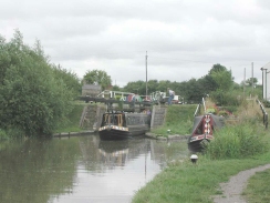
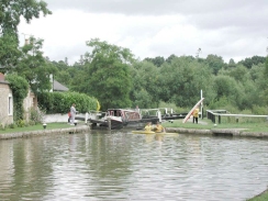
I stopped for twenty minutes at Soulbury Bottom Lock, where there is a lovely pub called 'The Three Locks'. The area around the pub was an absolute hive of activity, with bikers, boaters, walkers and people out for a Sunday afternoon drive all congregating by the lock.
The next section of walk will take me through Milton Keynes and on to Wolverton, just to the north of the station. This will swt me up well to walk to Blisworth on the next walk, where the Northampton Branch of the Grand Union Canal leaves the Main Line. Hopefully this will just mean that I need to take a bus into Northampton, and then a train back to Wolverton. When I have reached Wolverton I shall have walked abour half of the Grand Union Canal Main Line.
I am also quite pleased that I managed to walk with nearly a full pack (with only spare clothes and food missing from it). This leaves me hopeful that I will be able to do the walk from Creiff to Fort William that I am intending to do in a few weeks.
Directions
This walk starts at the car park at Cheddington Station, which is situated about four miles south of Leighton Buzzard. From the car park follow the railway line towards the road, where you will find a footpath leading up via some steps to the road overbridge beside the station (I did not realise that these steps were here until I reached the top of the bridge having walked the long way around via the station approach.
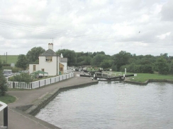
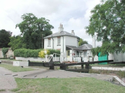
When you reach the top of the bridge, turn left and walk down the road until you meet the B488. Turn left down this road for a short distance before taking a footpath leading off to the right across fields. Enter the first field and follow the left hand hedge, ignoring a stile in it that belongs to another footpath. A stile at the far end of this field leads through into another one, and then another stile leads into an orchard. The navigation then becomes easier as it joins a bridleway leading to Horton Lock on the Grand Union Canal.
When the lock is reached turn left and go under the bridge. The walk then follows the towpath on the western (left-hand) side of the canal north to (and through) Leighton Buzzard, which you do not get to see from the canal.
From Leighton Buzzard the walk starts to turn to head northwestwards past the three locks (and the excellent Three Locks pub) at Soulbury before heading northwards again under the A4146. At Water Eaton bridge (number 98) leave the canal and join the road on top of the bridge. Turn left down this road and follow it until it meets two adjoining roundabouts. Take the road heading west from the second roundabout for about a kilometre until just before a bridge under the railway is reached. Turn right down a road that parallels the railway until you reach an overhead concrete railway viaduct. Head straight on past a pub until the dual carriageway B4034 is reached. Cross over the dual carriageway and turn left under the concrete viaduct and another bridge which carries the main line railway. At the other end of the bridge some steps lead up to the right, taking you to Bletchley Station forecourt.
Further information
|
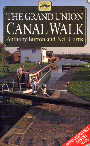
The walk is also covered in detail in the Grand Union Canal Walk, by Anthony Burton and Neil Curtis, ISBN 1 85410 244 3, published by Aurum Press Ltd. Click on the image to the right to go the Amazon page for this book.
For more details on the Grand Union Canal see Jim Shead's canal pages. |
|
Distances
| From | To | Distance (m) | Ascent (ft) | Descent (ft) |
|---|---|---|---|---|
| Cheddington Station | Leighton Lock | 6.1 | 89 | 148 |
| Leighton Lock | Bletchley Station | 7.2 | 184 | 180 |
This makes a total distance of 13.3 miles, with 273 feet of ascent and 328 feet of descent.
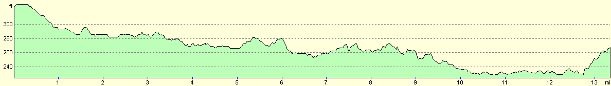
For more information on profiles, ascents and descents, see this page
Transport
There are regular train services between Cheddington, Leighton Buzzard and Bletchley oprtaed by Silverlink trains on the West Coast Main Line. For more details see the National Rail website.
Disclaimer
Please note that I take no responsibility for anything that may happen when following these directions. If you intend to follow this route, then please use the relevant maps and check the route out before you go out. As always when walking, use common sense and you should be fine.
If you find any information on any of these routes that is inaccurate, or you wish to add anything, then please email me.
All images on this site are © of the author. Any reproduction, retransmissions, or republication of all or part of any document found on this site is expressly prohibited, unless the author has explicitly granted its prior written consent to so reproduce, retransmit, or republish the material. All other rights reserved.
Although this site includes links providing convenient direct access to other Internet sites, I do not endorse, approve, certify or make warranties or representations as to the accuracy of the information on these sites.
And finally, enjoy your walking!
This walk was mentioned in the following routes:
| Grand Union Canal Walk |
Nearby walks
| # | Title | Walk length (miles) |
|---|---|---|
| 129 | Dunstable to Tring | 14.1 |
| 130 | Tring Station to Hemel Hempstead Station | 8.0 |
| 141 | Tring Station to Cheddington Station | 6.1 |
|
|

|