Walk #210: Rickmansworth to Stanmore via Middlesex's highest point
 |
 |
|
General Data
| Date Walked | 10/08/2002 |
| County | London, Hertfordshire |
| Start Location | Rickmansworth Station |
| End Location | Stanmore Station |
| Start time | 10.50 |
| End time | 14.25 |
| Distance | 9.2 miles |
| Description | The main purpose of this walk was to reach a certain point in Bushey Heath, which is the highest point in Middlesex and to ensure that this was connected up with the rest of my walks. It was a walk of two halves, with a nice walk along an abandoned railway line being followed by road walking through Bushey. |
| Pack | I carried my 30-litre Karrimor Hotrock rucksack which was filled with waterproofs and all the usual paraphernalia, including Psion 5 and spare batteries. |
| Condition | I feel fine after this walk. It had been well over a weeks since my last walk, so my lag muscles felt tight early on in the walk, but apart from this I had no real trouble. |
| Weather | The weather forecast was for heavy rain, but I saw the opportunity of going down to London to be too strong to resist. Fortunately during the walk there was no sign of any rain, and there were even periods of strong sunshine. This led to it being quite a hot walk, but I kept my fleece on regardless as I was carrying things in the pockets.. There was no real wind to speak of, so I got quite hot and bothered at times. |
| OS map | Landranger number 176 (West London, Rickmansworth & Staines) |
 |
 |
|
Map of the walk
Maps courtesy of Google Maps. Route for indicative purposes only, and may have been plotted after the walk. Please let me have comments on what you think of this new format. For a detailed table of timings for this walk, please see the table file.
Notes
The main aim of this walk was to reach the highest point in the county of Middlesex, as part of my County Tops walk. It is a walk that I had been meaning to do for over a year, but had never actually got around to doing.
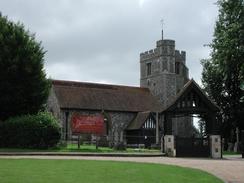
The churchyard of St Mary's church in Rickmansworth was a pretty little oasis in the bustle of the town, and the church itself was quite nice albeit with a modern extension off to one side. I passed many churches on this walk, and I enjoyed studying all of them as I passed.
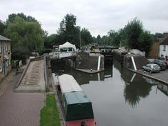
Batchworth Lock is quite a nice little area, with a nice open-air but covered brasserie where I have eaten in the past. There is also a little canal museum, and there are lots of boats about. It is a lovely place to stop for a quick rest and a bite to eat.
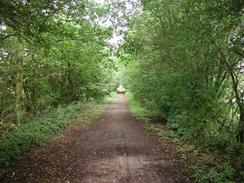
When planning this walk there was an obvious route to follow to allow me to get to Bushey from Rickmansworth; this was marked on the Land Ranger map by a black dotted line denoting an old railway line. This turned out to be the Ebury Way cycle path, a concessionary path. This path was a very nice way to make my way through northwest London and made the first part of the walk very enjoyable. For more details of the Ebury Way, see the Hertfordshire cycling website.
I was slightly limited in time on this walk, as I had to meet Sam and a friend in Leytonstone at 16.00. For this reason I decided not to walk to Borehamwood but to walk the shorter distance to Stanmore Station. This gave me a little extra time, so I decided to stop off for a quick pint of orange and lemonade at the Royal Oak pub in Bushey. This was quite a nice little pub opposite the police station, and I found that the ten-minute rest refreshed me considerably.
When I reached Bushey Heath I found it very hard to work out exactly where the highest point of Middlesex was located. The grid reference that I have was a six-figure grid reference, which is only accurate to 100 metres. The border between Middlesex and Hertfordshire runs down the middle of the road, and by judging by eye I believed that the highest point is where Lime Tree Walk leaves on the left.
I have now done all the walks that I need to do in North London, and only have a few more to do in South London before I start my big walk around the coast. I could do a few more walks to join Stanmore with the Lea Valley in the east or Harpenden in the north, but I have no real inclination to do either.
Directions
Leave Rickmansworth Station and turn right past two telephones there is a black tourist signpost one of which is marked 'canal centre'. Follow the sign towards the canal centre, past a bus stop and a multi-story car park for a short distance until the road ends at a junction with Homestead Road. At the junction turn right and pas under the railway, and after about fifty yards from the bridge turn left following yet another sign for the canal centre.
Continue along this road, passing some nice modern flats on the left until a mini roundabout is reached. At the roundabout turn right down Northway and follow the road as it becomes Church Street towards the church As he road passes the Festival Ale House it curves around to the left and the footpath leaves the road and enters the churchyard to pass the church, which is called St Mary's. The path through the churchyard meets the road once more beside a red phone box. Join the road and head down past Bridge Motors and cross onto the other side of the road before it ends at a big roundabout. At the roundabout head straight on for about fifty yards along a dual carriageway over a canal bridge. Batchworth Lock and the canal centre is to the left down some steps beside the bridge.
From the locks turn back and head back up the steps to the bridge over the canal and Church Street. Turn right and head back to the roundabout and head towards the church. Instead of heading through the churchyard continue along the road until you get to the war memorial in the churchyard on the left. At the memorial turn right down Skidmore Way following signs for the Ebury Way cycle path. The road curves around to the right and shortly before another right-hand turn Ebury Way leads off to the left.
The path skirts to the left of a little canal arm with canal boats on it before rising to climb over the canal arm. It then joins the formation of an old railway line. After a short distance the path splits into two; continue along the much clearer right-hand branch as it squeezes between two attractive little lakes. The track then passes over the canal just downstream of Lot Mead Lock. At the bridge a path leads up from the canal towpath below; this is an alternative route from Batchworth Lock avoiding walking back to the church.
After the path then crosses under the Metropolitan tube line an industrial estate is met on the right. On the left is Croxley Common Moor, a local nature reserve and a Site of Special Scientific Interest (SSSI). The Ebury Way continues as it passes the dead-end of a road, from which a footpath continues over the Way and across the common. The Way passes to the left of a large industrial building, and after the building a minor road joins on the right. The Way parallels the road until the bridge under the A4145 road is reached.
On the other side of the bridge the Way the built-up areas are left behind, and moor land is present on both dies, although power lines are overhead. In the gaps of trees nice views can be seen over Oxhey Woods in the distance to the south. The path continues on through a shallow and pretty cutting. The path then climbs out of a cutting to cross a small concrete road before descending once more back down into the cutting. The cutting ends and becomes an embankment and crosses the River Colne on a long bridge. A short distance after the bridge the path crosses the river once more using a very modern and fairly unattractive purple bridge.
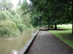
After the bridge the path reaches a National Cycle Network sign, where it turns to the right and fifty yards further on it passes under some power lines and turns to the left along a surfaced road. The road passes a quite gaudy children's playground, a skateboarding area and a basketball court, which is part of a riverside park. The road passes over the river. On the other side of the bridge turn left and follow a path that skirts the southern bank of the river until it ends at a road under a power lines. This path is part of the River Colne Linear Park, and it is quite a nice feature in the northern outskirts of London.
Turn left along the road to cross the river by a bridge until you get to the pedestrian crossing on the other side. Cross the road using the crossing and then turn right to re-cross to the southern riverbank. Here a path leads off to the left along the riverbank where there is a path to Bushey Arches. The path meets a large railway viaduct, at which it turns right and then left to pass under the viaduct before eventually ending at a road near another railway viaduct. Cross the road and turn right to head under the arches of the second viaduct along Chalk Hill Road. At a crossroads beside the Victoria Pub continue straight on up Chalk Road. To the right at this crossroads is Bushey Station, about a hundred yards up Aldenham Road.
Continue on up Chalk Road past the Methodist Church and the health centre. Chalk Road becomes High Street as it enters the centre of Bushey. The attractive St James', St Paul's and Holy Trinity church is passed on the right, which has a fairly unusual tower. The road passes the Bushey United Reform Church and curves around to the right. On the hillside to the right can be seen a golf course. The road then starts to climb a hill with the Horse and Chains pub to the right and then the police station on the right and the Royal Oak on the left.
Continue on up the hill past the library. When the road reaches forks with the church of St Peter, Bushey Heath, in the middle of the fork take the right-hand fork past the church and the Three Crowns pub. The road becomes High Road and continues on past St Andrew's Methodist Church until it ends at a large junction controlled by traffic lights. At the junction turn left up Magpie Hall Road, along which is the highest point of the county of Middlesex.
Continue along Magpie Hall Road until a mini roundabout is reached. At the roundabout turn right down to head south down the attractive Heathbourne Road, which has Stanmore Common on the right. After a few hundred yards the road ends at a T-junction with the A4140 road. Cross over to the other side of the A4140 road and turn left to head on down a light hill.
The road is called The Common and passes the Stanmore Cricket Club until it gets to the junction with Wood Lane on the right, where the road becomes Stanmore Hill. At the junction at the bottom of the hill follow the road as it curves to the left and becomes the Broadway for a short distance before becoming London Road. Stanmore Station is a little less than half a kilometre eastwards along London Road.
Distances
| From | To | Distance (m) | Ascent (ft) | Descent (ft) |
|---|---|---|---|---|
| Rickmansworth Station | Oxhey | 4.6 | 121 | 144 |
| Oxhey | Stanmore Station | 4.6 | 407 | 305 |
This makes a total distance of 9.2 miles, with 528 feet of ascent and 449 feet of descent.
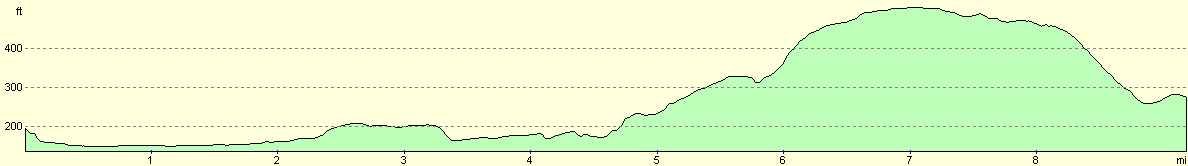
For more information on profiles, ascents and descents, see this page
Transport
Rickmansworth is served by trains on the Metrolitan tube line to Amersham, on which there are regular services from Baker Street Tube Station. Stanmore Station is the northern extremity of the Jubilee line, from where regular services run down into Central London. Working out how to get between the Jubilee and Metropolitan lines in Central London is left as an exercise for the reader.
Disclaimer
Please note that I take no responsibility for anything that may happen when following these directions. If you intend to follow this route, then please use the relevant maps and check the route out before you go out. As always when walking, use common sense and you should be fine.
If you find any information on any of these routes that is inaccurate, or you wish to add anything, then please email me.
All images on this site are © of the author. Any reproduction, retransmissions, or republication of all or part of any document found on this site is expressly prohibited, unless the author has explicitly granted its prior written consent to so reproduce, retransmit, or republish the material. All other rights reserved.
Although this site includes links providing convenient direct access to other Internet sites, I do not endorse, approve, certify or make warranties or representations as to the accuracy of the information on these sites.
And finally, enjoy your walking!
Nearby walks
| # | Title | Walk length (miles) |
|---|---|---|
| 60 | Slough to Alperton | 16.7 |
| 65 | Alperton to Paddington | 6.4 |
| 139 | West Drayton to Kings Langley | 16.6 |
|
|

|