Walk #858: A circular walk around the Isle of Portland
 |
 |
|
General Data
| Date Walked | 22/05/2010 |
| County | Dorset |
| Start Location | Wyke Regis car park |
| End Location | Wyke Regis car park |
| Start time | 10.36 |
| End time | 16.53 |
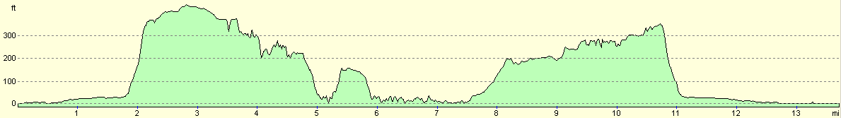
| Distance | 13.8 miles |
| Description | This was a highly pleasant walk following the coastal path around the Isle of Portland. |
| Pack | Today I carried my 30-litre Karrimor rucksack, filled with water, a book and other odds and ends. |
| Condition | I feel absolutely fine after this walk. |
| Weather | Today was bright, sunny and quite warm. The breeze was not fierce and quite warm. All in all it was an ideal day for walking. |
| OS map | Landranger number 194 (Dorchester & Weymouth, Cerne Abbas & Bere Regis) |
 |
 |
|
 |
 |
|
Map of the walk
Maps courtesy of Google Maps. Route for indicative purposes only, and may have been plotted after the walk. Please let me have comments on what you think of this new format. For a detailed table of timings for this walk, please see the table file.
 |
 |
|
 |
 |
|
Notes
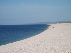
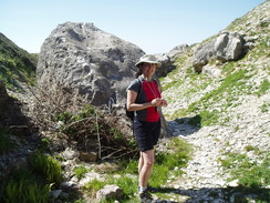
A couple of years ago Sencan and I had started walking the South West Coast Path; we had not done any of it for ages, but with good weather forecast we decided to restart the walk. Although we had walked past Weymouth we had not done the Isle of Portland, and this felt like a pleasant stroll to get her back into walking the coast. We shared the drive down to Weymouth, then parked in the large car park that borders the shingle bank of Chesil Beach at Wyke Regis. Before we got kitted up we went to the visitors centre, and I bought a lovely bacon bap - just what I needed. We had both decided to curse the rain gods by wearing shorts, so we slapped on our hats and slopped on sun tan lotion before heading off.
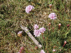
The initial stretch of the walk was hardly superb. An area of water called the Fleet lies between Chesil Beach and the mainland; the foreshore of this was covered with a scattering of pink Thrift amongst the shingle. We crossed the road to join the embankment that carried the old railway line onto the island; to our left there was a Royal Navy boat, a reminder of how important the harbour was to national security. Soon the causeway ended and the road headed south along the island. When I walked this way in early 2003 there was a farm of oil tanks to the left, but the area was now a newly-built industrial estate called Osprey Quay that houses, amongst others, a Maritime and Coastguard Agency building. This will be a major focus of the 2012 Olympics sailing efforts.
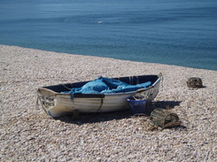
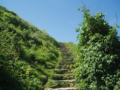
The waymarking on the island was not as good as it is on the South West Coast Path proper, but it proved easy to find the place where the path left the road and headed towards the promenade in Chiswell. On the way we passed some men who were opening up scallops, and the old shells decorated the walls of a nearby building. After passing a pub we joined the promenade proper. A few small boats had been pulled up onto the shingle, but our attention was dominated by the hillside that rose up in front if us. It looked steep, and as we climbed it turned out to be steep. It was a relief when the steps ended and we reached the top.
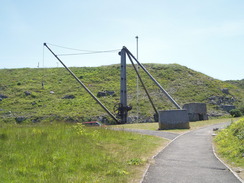
A crane had been set up at the top, a reminder to the quarries that dominated the island. Portland stone was a major export from the island, and was used to construct many famous buildings including St Paul's Cathedral and the Palace of Westminster. For this reason the path around the island passes countless quarries, and signs of ancient quarrying is ever-present. We crossed the road to climb up to a little memorial area, beside a hotel from which we picked up a friend of Sencan's a few weeks ago after she was trapped by the Icelandic ash cloud. Nearby was a memorial to HMS Sidon, a submarine that blew up when a faulty torpedo exploded in Portland Harbour in 1955, killing thirteen men. Adjacent is a war memorial, with what must be the grandest views of any war memorials in the country.
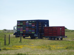
A road walk took us across the heights at the northern end of the island. Some trailers were set up on a grassy area, pigeon transports that looked more like prisons. The trailers came from Blackpool, and we wondered if the pigeons themselves had come from the northwest. Soon afterwards we were crossing the defences of the Verne Citadel, an old military fort built on the highest point of the island that is now a prison. The prison and the associated ex-Naval dockyard prevents the path from taking a more coastal route around the northern side of the island, but this is offset by the superb views from the heights.
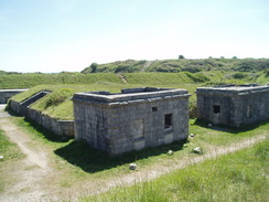
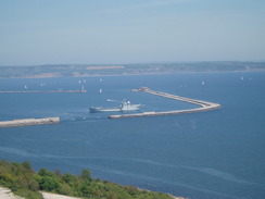
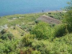
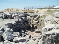
Shortly after passing an entrance into the prison we went wrong, passing through the grounds of the High Angle Battery instead of skirting around its northern perimeter. A family were camping in the battery, and they were enjoying throwing water balloons around in the sunshine. We rejoined the coast path a short distance on, beside an old engine shed standing on the cliffs at the eastern side of the island. A long incline led down to the north; this (and the engine shed) was used to get stone down from the quarries to construct the breakwaters of Portland Harbour (the construction took literally years; from 1849 and 1872). The southern breakwaters could be seen from the clifftop, and directly below the engine shed were the massive stone constructions of an old rifle range, now slowly being reclaimed by nature.
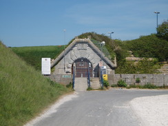
The path passed the high walls of the Grove Young Offender Institution before passing two tall ventilation chimneys, apparently part of a series of military tunnels below. A pleasant (and thankfully level) clifftop walk followed, with a large, overgrown area far below, including the course of an old railway line. I wondered if the whole area had been created by quarrying; certainly the area looked as though it had been thoroughly shaped by man.
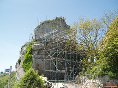
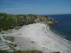
Eventually a descent started down towards Church Ope Cove, the only beach on this eastern side of the island High above were the remains of the thirteenth-century St Andrew's Church, whose grounds apparently include a pirate's graveyard. The church was closed centuries ago after a landslide, which is easy to believe from its position at the top of a cliff, and the ruins were clad in scaffolding as we passed. The path passed behind the pebble beach of Church Ope Cove before clambering up to cross the Southwell Landslip. There were signs of more quarrying activity here, including some seemingly carefully-sculpted blocks that appeared to have been abandoned after completion.
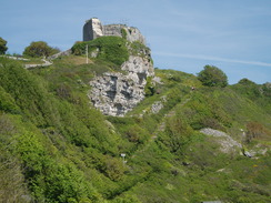
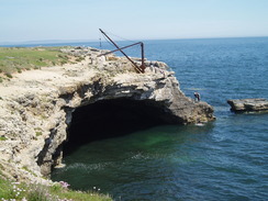
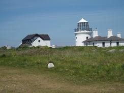
The path climbed up to join a road on the clifftop to Freshwater Bay, after which it ran along a footpath southwards. The views out to sea were superb as the cliffs slowly lowered in height, and the first glimpses of the red-and-white striped Portland Bill lighthouse became visible. At one point there was a wide-mouthed cave which some men were jumping from into the water below.
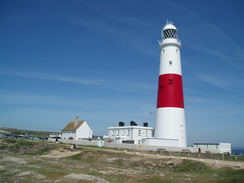
It was a relief to reach the lighthouse (actually one of three in the immediate area). We stopped off here to eat our lunch, sitting on a bench. I was wearing my new boots, a pair of Scarpa Trek GTXs, and I took these off to let me feet breathe for a while. Sencan kindly bought a couple of ice creams, and we scoffed these down, trying to eat them before they melted in the heat.
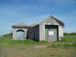
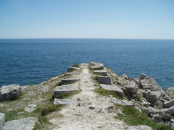
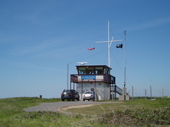
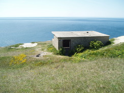
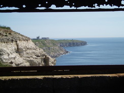
The return journey was a little easier; the path slowly climbed as it headed along the western side of the island, passing a Coastwatch lookout before reaching an incredibly ugly building - military, perhaps? It was an easy and enjoyable walk, with some wonderful views out to sea. At one point we passed an old pillbox and I went down to have a look inside - along with remains of a fire were some spectacular views, the rusted girders framing the view back along the coast.
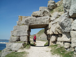
Soon the path passed through another old quarry, along with a fairly spectacular arch over the path made from stone blocks. It was getting hotter as the afternoon wore on, and we headed off the path for a short distance to explore and examine some of the exposed rock formations.
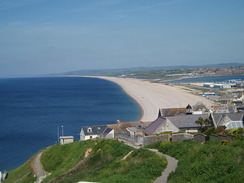
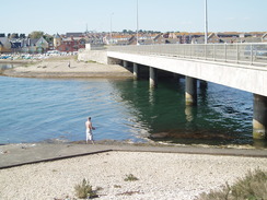
The climb up the western coastline had been remarkably easy, and we were soon peering down the steep ascent that we had clambered up earlier. It was far easier to descend than the clamber up had been, and it did not take long to reach the promenade in Chiswell. The pub - which had been empty earlier - was now packed with people enjoying the sun along with a pint. What followed was another long slog north along the road, with the shingle bank of Chesil Beach off to the left. When we reached the car park we continued northwards to reach the Ferry Bridge pub, which is situated just to the north of the bridge over the Fleet. This rejoined us with the coast path proper, after which we turned back for the short stroll to the car park.
It had been a spectacular walk, and one that I would love to do again sometime. The Isle of Portland has so much of interest packed into it, from the old quarries, the military history and great sea views. This walk is highly recommended.
Directions
| During this walk I followed the South West Coast Path, the route of which is detailed in the Ordnance Survey National Trail Guide 11, Exmouth to Poole (ISBN 1-854109-88-X). Unfortunately the route description is written in reverse to the direction that I am walking, but the 1:25,000 maps in the book are clear and the signs on the ground are very good. Also to be recommended is the South West Coast Path Association guidebook (ISBN 0-907055-04-4), which has less concise directions and no maps but does include accommodation details and grades each section of the walk according to difficulty. They also publish reverse directions, which are suitable for walking in the direction that I walked the route. They have a website at www.swcp.org.uk, which is well worth a visit. | 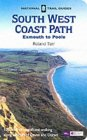
|
| 
| |
| |
| |
The route for this walk was detailed in the South West Coast Path Association guidebook, which has some reasonable directions but no maps. There were some national trail signs on the route, and navigation was relatively simple using the 1:50,000 map and the signs.
 |
 |
|
 |
 |
|
Distances
| From | To | Distance (m) | Ascent (ft) | Descent (ft) |
|---|---|---|---|---|
| Car park | Church Ope Cove | 5.3 | 983 | 955 |
| Church Ope Cove | Portland Bill | 2.3 | 394 | 427 |
| Portland Bill | car park via Wyke Regis | 6.2 | 671 | 676 |
This makes a total distance of 13.8 miles, with 2068 feet of ascent and 2058 feet of descent.
For more information on profiles, ascents and descents, see this page
 |
 |
|
 |
 |
|
 |
 |
|
 |
 |
|
 |
 |
|
 |
 |
|
 |
 |
|
 |
Disclaimer
Please note that I take no responsibility for anything that may happen when following these directions. If you intend to follow this route, then please use the relevant maps and check the route out before you go out. As always when walking, use common sense and you should be fine.
If you find any information on any of these routes that is inaccurate, or you wish to add anything, then please email me.
All images on this site are © of the author. Any reproduction, retransmissions, or republication of all or part of any document found on this site is expressly prohibited, unless the author has explicitly granted its prior written consent to so reproduce, retransmit, or republish the material. All other rights reserved.
Although this site includes links providing convenient direct access to other Internet sites, I do not endorse, approve, certify or make warranties or representations as to the accuracy of the information on these sites.
And finally, enjoy your walking!
Nearby walks
| # | Title | Walk length (miles) |
|---|---|---|
| 316 | Lulworth Cove to Wyke Regis | 13.7 |
| 317 | A circular walk around the Isle of Portland | 13.3 |
| 318 | Wyke Regis to West Bexington | 14.3 |
|
|

|