Walk #857: Westbury to Bath
 |
 |
|
General Data
| Date Walked | 20/05/2010 |
| County | Wiltshire, Avon |
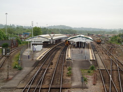
| Start Location | Westbury station |
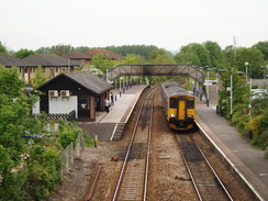
| End Location | Bath Station |
| Start time | 08.00 |
| End time | 16.14 |
| Distance | 22.8 miles |
| Description | This was a pleasant walk that headed north out of Westbury, before following the Kennet and Avon canal as it wound westwards towards Bath. Once in Bath, I extended the walk by following the Avon Walkway out of the town before looping back to the station. |
| Pack | Today I carried my 30-litre Karrimor rucksack, filled with water, a book and other odds and ends. |
| Condition | My feet are a bit of a mess after this walk, a symptomn of the hard ground underfoot (tarmac or rubble paths) and the fast pace that I set myself. |
| Weather | Today was mostly cloudy, with some sunny periods starting later in the afternoon. It was fairly warm and humid. |
| OS map | Landranger number 183 (Yeovil & Frome, Shaftesbury & Shepton Mallet), Landranger number 173 (Swindon & Devizes, Marlborough & Trowbridge) and Landranger number 172 (Bristol & Bath, Thornbury & Chew Magna) |
 |
 |
|
 |
 |
|
Map of the walk
Maps courtesy of Google Maps. Route for indicative purposes only, and may have been plotted after the walk. Please let me have comments on what you think of this new format. For a detailed table of timings for this walk, please see the table file.
 |
 |
|
 |
 |
|
Notes
I was scouting around for more walks now that the long saga of the Wessex Ridgeway had been completed. During the various day-outings and trips I had noticed that Westbury, where one of the walks started, was a convenient starting point for a walk to Bath. I have walked to and from Bath on several occasions, and it felt right to be visiting it once again. As both the start and end points of the walk were on a railway route from near my home in Romsey, it seemed sensible to be catching the train instead of driving. Therefore Sencan dropped me off at the station before seven, and a little under an hour later I was getting off in Westbury.
The first part of the route hardly promised to be a classis; I had to get from Westbury to the Kennet and Avon canal north of Trowbridge, and there seemed little alternative than to walk along the roads, with footpaths where possible. The first stretch of road was busier than I expected, and I took care on the pavementless roads. A police car came screeching past me, and a minute later I came across a queue of traffic heading in my direction. Soon I came across the cause: two cars were oblique across the road, with glass and debris scattered around. One of the drivers appeared to be in a bit of a mess, with another woman in the back seat, holding the driver's neck. There seemed to be plenty of people about so I headed off, joining a footpath that headed up towards the hamlet of Norleaze.
On the outskirts of the village I stopped to chat to a local who had a wonderful Wiltshire accent - it was worth just listening to him talk, which was a good thing as he seemed to do nothing but talk. Eventually I excused myself and, after joining the main road for a short distance, joined another footpath that would take me towards North Bradley. The path across the fields were invisible, so instead I walked around the edges of fields and paddocks, before reaching a stile that was surrounded by nearly impenetrable vegetation.
More roads took me north into Trowbridge. On the way I passed a B&Q shop, but unfortunately there was no burger van outside. Instead I munched on a Snickers bar, and before I knew it I was at the railway station. It was my first time in Trowbridge and I was not impressed - there was little of note to see. However, there seemed to be more of interest (a historic centre) just off my route to the northeast of the River Biss.
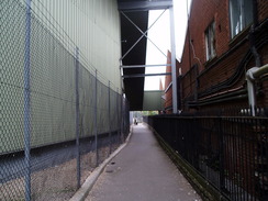
A footpath is shown leading off from the station, running for over a mile to the Kennet and Avon canal. It seemed to start alongside the railway line, but I could not see the entrance. Instead I walked back to the road and took a footpath that ran through tall, looming buildings of a factory complex. Soon I reached the place where the cycle path joined in the station car park; annoyingly, very near to where I had stopped looking.
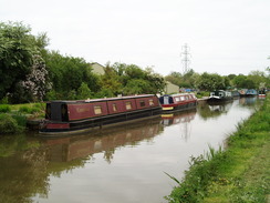
After crossing the River Biss the path ran alongside the railway line, sometimes level with it, and at others climbing above it. Soon the canal was reached near a bridge that allowed me to access the towpath on the other side. Some workmen were eating their snap near the bridge, basking in the sunshine as they ate. What followed was a pleasant stroll westwards alongside the canal into Bradford-on-Avon. I had walked along this stretch of the canal ten years before, and could remember very little about it (especially as I was walking in the opposite direction). Therefore it felt like I was walking it for the first time, and could look upon the scenery with fresh eyes.
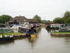
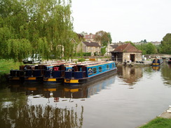
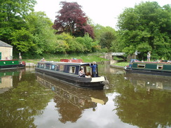
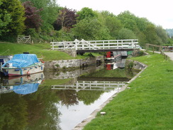
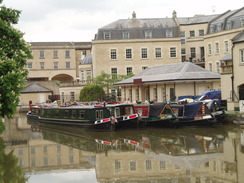
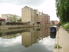
After passing a marina the path took me through the centre of Bradford-on-Avon, which is a superb little town. The area surrounding the lock was busy with a gaggle of foreign schoolchildren, and strangely this if anything this added to the ambiance. Boats were moored nearby, and there was what I believe is a dry dock for narrow boats under repair. After crossing a road I passed a series of canalside buildings, each of which appeared to have a cafe or shop within. It was tempting to stop and have a bite to eat, but my feet were feeling fine so I decided to plod on.
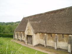
Shortly afterwards I saw a large building below to my right - a medieval tithe barn dating back to 1334. Again it was tempting to stop to have a look, but instead I plodded on along the towpath, with the River Avon glinting in the sunshine below. The pleading shouts of coxes rose up from the eights rowing on the water, and they boats became visible briefly through gaps in the trees. It was turning out to be a wonderful day, and the heat was increasing.
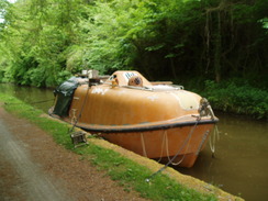
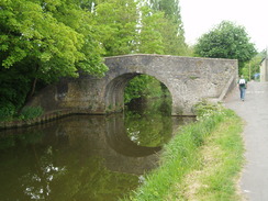
The canal crossed high above the Avon on the Avoncliff aqueduct, which is right beside the Avoncliff railway station. I crossed the aqueduct, then discovered that the towpath ran along the other side. I had to return to the southern end then take a steep path that passed a pub and crossed through the arch of the aqueduct. Once safely on the other side the towpath was scenic and tree-lined; a superb walk. I passed what had to be one of the ugliest boats I have ever seen on a canal; a self-righting bright orange lifeboat with virtually no windows. Whilst this would not have looked out of place in a harbour, it was an eyesore on the green canal.
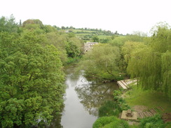
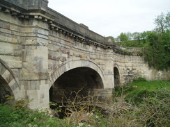
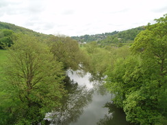
Some pleasant views could be had over Limpley Stoke before the canal turned to head northwards to reach Dundas Aqueduct, where the canal once again crossed over the river. From here the canal loops northwards into Bath; ten years earlier I had missed out this loop by climbing over Claverton Down, a hillier but more direct route. Today I wanted to complete the canal, however, so I followed the towpath on the eastern side of the canal. In the valley to the right was the River Avon and the railway line.
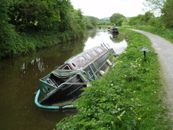
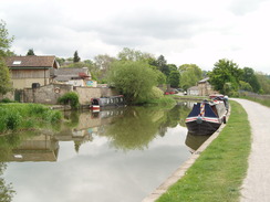
Soon I passed the site of Claverton pumping station, built in 1813 to pump water 48 feet up into this high section of the canal. The area was becoming more genteel; more boats lined the banks and the wooded hillside to my left looked superb. This impression was spoilt by a half-sunken narrowboat that was covered in British Waterways aware' stickers - a sad sight. It was surrounded by an inflatable pipe - presumably a barrier to prevent leaking oil from polluting the canal as a whole.
The canal started twisting, and then a pub was reached on the right. It seemed like a good time to stop, so I went in, bought myself a pint and went to sit down outside. I had been walking over gravel and tarmac for most of the day and my feet were starting to ache, so I took my boots off and basked in the glorious sunshine.
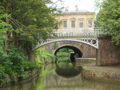
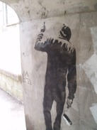
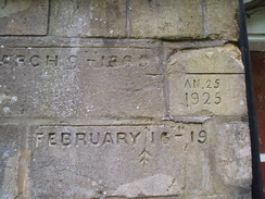
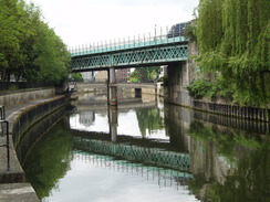
It took a few minutes for my feet to get used to having the boots back on when I set off, but the discomfort was more than compensated for by the views off to the right. The hillsides to the north of Bath were lined with houses made of glorious Bath stone, seemingly sparkling in the sunshine. The surroundings slowly became more urban as the canal curved to head southwards to Bath, and a series of locks took the canal down towards the level of the River Avon. The canalside architecture became splendid; two short tunnels with grand iron bridges spanning the water between. It was, frankly, a superb walk. On the side of one canal bridge I saw what I suspect is an original Banksy artwork, of a man holding a paint roller, with a large expanse of white paint nearby. It is a worl away from oridnary graffiti or tagging. A little further on was another bridge, which had marked on it the flood levels from various years - the ehights are quite spectacular, and the river in full flood must be a fierce beast.
I did not notice when the canal became the canalised River Avon in the centre of the city. Soon I was passing a bridge that carried the GWR over the river, and Bath Spa railway station was a short distance away. It was still early, however, so I decided to continue along the river for a couple of miles. This is the start of the Avon walkway, a path that follows the river through to Bristol and beyond to near the mouth with the River Severn. This is a walk that I want to do sometime soon - perhaps next week - but the stretch was pleasant enough to do twice.
When I reached a lock I turned off the riverside path, climbing uphill and crossing a narrow bridge over an old railway line. This brought me out onto a road that I started following back into the city centre. Terraced houses made of Bath stone lined either side of the road, the detailing of the stonework on some particularly fine. This was followed by a more austere area, and by this point my feet were really starting to ache. I hobbled on, ignoring much of what I saw as I passed through the city centre as I concentrated on getting to the station.
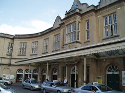
It was frankly a relief when the station loomed up in front of me. I was famished and I bought a baguette from a shop and went to wait for my train. It had been a very pleasant day's walk, but the hard ground had been surprisingly tough on my feet.
 |
 |
|
 |
 |
|
Directions
This walk starts off from Westbury station. Leave the station and turn left to start heading east along the station approach. When this turns to the left with a railway yard to the left, head up some steps to reach Station Road. Turn left to cross the railway line on a bridge, and follow the road as it curves to the right, becoming the Ham. The road passes some houses before turning to the left to head northwards. There is no pavement on this stretch of busy road, so care needs to be taken.
When a road comes in from the left (leading to the West Wilts Trading Estate) turn right along another road. After about a hundred yards Hawkeridge Farm is reached on the right; here turn left and cross a stile to join a footpath that heads northwards across a series of small fields. The footpath ends at a road; follow this northwestwards for a short distance, and when it curves to the left continue straight on to join another footpath that crosses a field to reach the road once more.
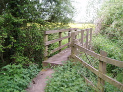
Turn right along the road for a short distance, crossing Horse Bridge. Turn left after Laurels Farm to join a footpath that heads northwestwards across fields; keep the field boundary on the left and follow it as it curves to the right, before heading through the hedge to cross a footbridge. On the other side follow a hedge on the right, passing under some power lines before reaching another hedge. Cross a stile and then a footbridge to reach another field. From here the path was unclear because of crops, so I walked around the edges of some fields to reach a road immediately to the northwest of Manor Farm, on the southern outskirts of North Bradley.
Turn left and follow the road as it heads through North Bradley. The village seamlessly becomes the southern outskirts of Trowbridge. After half a mile a roundabout is reached with the A363; continue straight on to head north into Trowbridge. Another mile further on the centre of the town is reached. Head straight on over a roundabout with the A361 road, and then take the next road off to the right, Frome Road. When this soon ends, turn left up Newtown Road that reaches a road junction by a church. Turn right down Stallard Street and follow the road as it crosses the railway line on a bridge.
Immediately on the other side of the bridge, turn left to descend down some steps to reach the station forecourt. Head straight on, keeping the railway line to your left, and head through the car park. Soon a gap in the fence appears on the right, giving access to a cycle path that runs alongside the railway line, heading northwards for a mile until it reaches the Kennet and Avon canal. Cross a bridge to the right, and then turn left to start heading westwards along the canal.
After a couple of miles the canal reaches a road in Bradford-on-Avon; turn right and then left to rejoin the towpath alongside some buildings. Follow the canal westwards for nearly one and a half miles to Avoncliff Aqueduct. Before crossing the aqueduct turn right down a path that leads towards a pub, then turn left to take a path under the bridge. On the other side turn left to clamber up to the towpath, which now runs along the other, southern, bank of the canal. The canal turns to the right to head northwards; after 2.5 miles Dundas Aqueduct is reached.
Cross the aqueduct and follow the canal as it turns sharply to the north. Cross a footbridge to access the eastern bank of the canal, and continue along the towpath for five and a half miles as it curves around Bathampton, eventually heading down a flight of locks to reach the River Avon in the centre of Bath. Bath Spa station is a short distance away to the right; however, I extended the walk by continuing along the footpath that runs along the northern bank of the river.
After a couple of miles, at St726648, I turned right to leave the river, heading up Osborne Road. This curved to the right and immediately left, to cross a narrow bridge over an old railway line. The road ended at the A4 Newbridge Road; turn right and follow the A4 eastwards for a little over a mile towards the centre of Bath. When the A4 peels off to the left, continue straight on along the A367 for a hundred yards . When this curves sharply to the right, continue straight on along Monmouth Street, Westgate Buildings and finally James Street West to reach Bath Spa station.
 |
 |
|
 |
 |
|
Distances
| From | To | Distance (m) | Ascent (ft) | Descent (ft) |
|---|---|---|---|---|
| Westbury station | Trowbridge station | 4.8 | 69 | 144 |
| Trowbridge station | Dundas Aqueduct | 8.0 | 446 | 486 |
| Dundas Aqueduct | Bath Spa | 5.8 | 259 | 279 |
| Bath Spa | Bath Spa via loop | 4.2 | 210 | 203 |
This makes a total distance of 22.8 miles, with 984 feet of ascent and 1112 feet of descent.
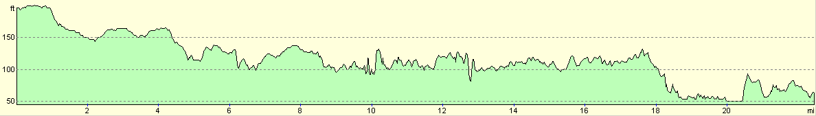
For more information on profiles, ascents and descents, see this page
Transport
There are regular, direct train services running between Bath Spa and Westbury stations.
 |
 |
|
 |
 |
|
 |
 |
|
 |
 |
|
 |
Disclaimer
Please note that I take no responsibility for anything that may happen when following these directions. If you intend to follow this route, then please use the relevant maps and check the route out before you go out. As always when walking, use common sense and you should be fine.
If you find any information on any of these routes that is inaccurate, or you wish to add anything, then please email me.
All images on this site are © of the author. Any reproduction, retransmissions, or republication of all or part of any document found on this site is expressly prohibited, unless the author has explicitly granted its prior written consent to so reproduce, retransmit, or republish the material. All other rights reserved.
Although this site includes links providing convenient direct access to other Internet sites, I do not endorse, approve, certify or make warranties or representations as to the accuracy of the information on these sites.
And finally, enjoy your walking!
Nearby walks
| # | Title | Walk length (miles) |
|---|---|---|
| 72 | Bath to Devizes | 19.3 |
| 126 | Farrington Gurney to Bath | 12.6 |
| 616 | Cotswold Way: Bath to Tormarton | 18.2 |
|
|

|