Walk #492: Inversanda to Clounlaid
 |
 |
|
General Data
| Date Walked | 07/07/2003 |
| County | Highlands |
| Start Location | Inversanda |
| End Location | Clounlaid |
| Start time | 10.29 |
| End time | 16.34 |
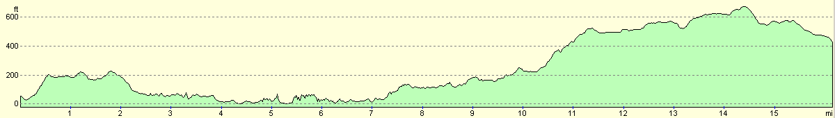
| Distance | 16.2 miles |
| Description | This was a long road walk, along quiet roads that go quite high over the hills. |
| Pack | Today I carried my 30-litre Karrimor HotRock rucksack, which was filled with my packed lunch, waterproof leggings, water bottle and a couple of spare shirts, together with the usual assortment of odds and ends. |
| Condition | I felt better today than I have for some time; my stomach was not as bad as it has been, my calves were not as sore and my right shoulder only ached a little and occasionally. |
| Weather | Today was an extremely wet day, with only about half an hour when it was not raining. Fortunately it was not a cold day and the wind was not blowing too strongly. |
| OS map | Landranger number 49 (Oban & East Mull) |
 |
 |
|
 |
 |
|
Map of the walk
Maps courtesy of Google Maps. Route for indicative purposes only, and may have been plotted after the walk. Please let me have comments on what you think of this new format. For a detailed table of timings for this walk, please see the table file.
Notes
I was feeling so bad after Saturday's walk that I chose to take a day off to see if it would help me recover. I did not do much during the day except lie down and read, and this appears to have done some good. I cannot help but feel that I have wasted a day, but the way I felt on Saturday was not conducive to walking a long distance. When I woke up this morning I was feeling a fair bit better, although I was still not operating at one hundred percent. The route that I walked today was not going to be the route that I had planned to do, which was to walk along a path from Kingairloch to Glensanda and then inland via Loch Tearnait to Lochaline. This was not really achievable as I had eight miles to walk to Glensanda, and there was no way that I could walk along the rough track to Lochaline in a day, particularly as I am not firing on all cylinders. For this reason I walked along the road instead, and this was a great shame.
This morning we drove to the library in Strontian so that I could check my emails. I had not done this for some time, and I had a few fairly urgent ones to reply to. One of the things that I miss most about this walk is the ability to surf the Internet as regularly as I used to, but when I do finally get access I find that I get bored very easily - once I have checked my emails and surfed a few select sites I have done everything that I want to do. I had a few nice emails to answer, and it amazes me how much people are buying into this whole walk. The strange thing is that I do not feel as though I am doing anything special - having done well over 4,500 miles I feel as though anyone could do such a long walk. After all, if I can do it, who couldn't? This is probably a slightly silly attitude to have, but it is how I feel about the walk - I doubt I will have any massive feeling if achievement even when I reach the end of the walk in Edinburgh..
The rain was falling heavily by the time that we reached Inversanda and I got my kit on ready to start the walk, and the mere thought of going out into the rain was depressing. Due to the weather I decided to wear my new pair of boots (the fourth of the trip), and they did not give me any blisters despite the fact that they were not broken in. I also forgot to put the proper footbeds in, and this made them more uncomfortable than they should have rightly been. This pair of boots should see me through until the end of the walk, especially as there is lots of road walking to be done before I reach Edinburgh, and I should be able to share the load with my trainers. Wearing trainers on the long road walks is so much nicer than wearing my boots, as they are much easier on my feet. The only downside is that the trainers are fairly hopeless when it is wet, and my feet end up getting wet very easily. This is even truer with my new pair of trainers, as much of the material is nothing but a series of holes stitched together. On the positive side, at least this makes them quick drying!
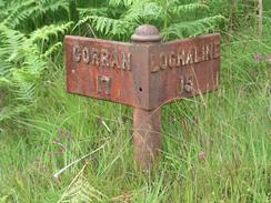
One of the features of the roads over the last couple of days have been the mileposts, which have been made of cast iron. So many of these have been removed and destroyed in England, and it is nice to see long stretches of roads on which they still exist and are intact. Unfortunately the main roads tend to have milestones, and many of these were painted and not engraved so the stones are still present but they are illegible. I can only hope that these sentinels of the road - now so outdated in the days of cars, detailed maps and satellite navigation - are kept on and not removed when roadworks and alterations occur.
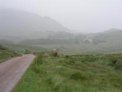
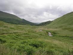
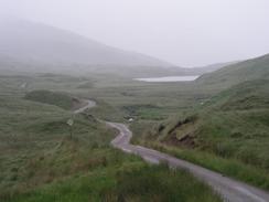
The road went fairly high at times, and as I passed Loch Uisge there should have been some great views. Unfortunately this was not to be, as the weather descended and it started to drizzle and then rain. Near the loch some heavy road works were going on, and there were many diggers creating some sort of road - I am unsure about whether this was a new stretch of access road for something or other, or an upgrading of the existing road. Whatever it is it must be costing a lot of money, as the works for it were very large. A little further on a low load carrying a large dumper truck passed me, obviously heading for the works. All of this has intrigued me, and when I get Internet access I shall try and work out what they are building.
I am fairly glad that I finished the walk when I did, as it soon started pouring with rain once again. There was nowhere to park on the road, so we chose to drive to Lochaline for the night and find a hotel where we could park. The rain was fairly fierce at times, and I was glad that I was in Mervan rather than outside and walking still. I can only hope that the weather will improve, as another wet day may prove to be more wearisome. Later on we went to the pub and got extremely drunk, which was nice for a change. It is very much a local pub, and we chatted to a bunch of people, including a group of scuba divers who were visiting the area. One of the things that surprised me was that there were some miners in the pub - mining not coal, or limestone, but sand! Apparently the sand in the area is particularly pure, and they mine it underground and transport it out to ships. Among other things it is used for making Guinness bottles, which apparently needs pure sand.
Tomorrow I will continue along the road through Lochaline, and then onto Bunavullin. This will be yet another shortish day, but after Bunavullin I will be following tracks and paths for a fair few miles, and so I shall have to end tomorrow there and tackle the harder bits the day afterwards. I can only hope that I feel better than I do today, or the walk will be most unmemorable for me. On the positive side the vast majority of the walk will be along roads, and this means that it should be fairly easy and untroubled walking.
Directions
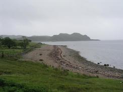
This walk starts off from the A861 / B8043 road junction in Inversanda. Head southwestwards down the road for three miles as it head inland slightly from the coast, passing Lochan Doire Bhraghaid on the way to Kilmalieu. From here the road follows the coast much more closely, and follows it around the headland of Rubha na h-Airde Uinnsinn before crossing Glengalmadale Water. The road then enters Kingairloch and starts to climb uphill westwards for a few miles, passing Loch Uisge before eventually ending at a junction with the A884 road. At the junction turn left and walk south for three miles along this road. This walk ends just beyond the farm at Clounlaid on the A884 road.
Distances
| From | To | Distance (m) | Ascent (ft) | Descent (ft) |
|---|---|---|---|---|
| Inversanda | Kingairloch | 8.3 | 922 | 827 |
| Kingairloch | Clounlaid | 7.9 | 965 | 686 |
This makes a total distance of 16.2 miles, with 1887 feet of ascent and 1513 feet of descent.
For more information on profiles, ascents and descents, see this page
Accommodation
We parked Mervan in a car park beside the Lochaline Hotel, who kindly allowed us to park there.
Disclaimer
Please note that I take no responsibility for anything that may happen when following these directions. If you intend to follow this route, then please use the relevant maps and check the route out before you go out. As always when walking, use common sense and you should be fine.
If you find any information on any of these routes that is inaccurate, or you wish to add anything, then please email me.
All images on this site are © of the author. Any reproduction, retransmissions, or republication of all or part of any document found on this site is expressly prohibited, unless the author has explicitly granted its prior written consent to so reproduce, retransmit, or republish the material. All other rights reserved.
Although this site includes links providing convenient direct access to other Internet sites, I do not endorse, approve, certify or make warranties or representations as to the accuracy of the information on these sites.
And finally, enjoy your walking!
This walk was mentioned in the following routes:
| My walk around the coastline of Britain |
Nearby walks
| # | Title | Walk length (miles) |
|---|---|---|
| 487 | Ferlochan to Duror | 21.3 |
| 488 | Duror to Fort William | 22.7 |
| 491 | Camusnagaul to Inversanda | 17.0 |
|
|

|