Walk #496: Salen to Kilchoan
 |
 |
|
General Data
| Date Walked | 12/07/2003 |
| County | Highlands |
| Start Location | Salen |
| End Location | Kilchoan |
| Start time | 09.06 |
| End time | 15.57 |
| Distance | 17.5 miles |
| Description | This was a quite enjoyable walk, mostly along roads but also including a short section of moorland path. |
| Pack | Today I carried my 30-litre Karrimor HotRock rucksack, which was filled with my packed lunch, waterproof leggings, water bottle and a couple of spare shirts, together with the usual assortment of odds and ends. |
| Condition | For the first time in what seems like ages, my neck and right shoulder gave me no troubles. I did have a little trouble with my right ankle, which was aching from early on in the walk, but not too much. |
| Weather | Thank goodness that today was mostly dry after the heavy rain of yesterday. There was hardly any sunshine, but the clouds did not give any rain except for a few drizzle showers. It was actually quite a cool day, and there was a breeze that did not hep matters. |
| OS map | Landranger number 40 (Mallaig & Glenfinnan, Loch Shiel) and Landranger number 47 (Tobermory & North Mull) |
 |
 |
|
 |
 |
|
Map of the walk
Maps courtesy of Google Maps. Route for indicative purposes only, and may have been plotted after the walk. Please let me have comments on what you think of this new format. For a detailed table of timings for this walk, please see the table file.
Notes
I took another day off yesterday, which was quite unintended. It had rained hard for most of the night, and it was still raining in the morning when I woke up. I did a little work on the computer, and I kept on delaying the time that the walk would start as the rain was hurtling down like stair rods. By ten there was a clear gap, and as I started to pack my rucksack it started to rain again. I was feeling fairly low and the last thing that I wanted was to get soaked, and so the decision that I had to make was more or less made for me. Before I set out on the trip I said that I would finish in a year, and I am scheduled to finish way ahead of this. When the trip started it took me ninety-two days before I took a day off, but as I near the end the time pressures are getting less and I feel easier about finishing the walk on time. I made best use of the day - I am planning to write a book about the walk once I finish, and I worked out a provisional layout for the book and the chapters. I also used the opportunity to get another website update written and sent off to Terry as well. Thus despite taking a day off I really did not have much of a rest, and indeed I often find walking to be more restful than the days off!
This morning I woke in a deep depression that I just could not lift myself out of. I could not put my finger on exactly why I was depressed, but I have been feeling ill at ease with my apparent lack of progress - I feel as though I have been on the west coast for ages. I would not go as far as to say that I wanted to end the walk, but I lay on the couch and asked myself why I was doing it. The rain that dominated yesterday had finally stopped, but this had been replaced with a grey and heavy sky that looked as if it may open at any time. This view did not do anything to make me feel happier, and it was with a heavy heart that I got ready for the day's walk.
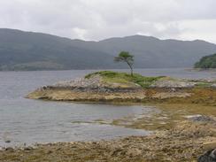
Initially I followed a long stretch of tree-lined road along the northern bank of Loch Sunart. This was a fairly boring plod, and was in itself fairly depressing as I could see the walk along the southern bank of the loch and Loch Tracuis, which I had walked along a couple of days before. The views were nice enough however, and this counteracted the negative feelings. I met Sam at the Clan Morrisson Hotel a short distance to the east of Borodale, and we went in for a little drink and an early lunch. We had a chat to the owner of the hotel, and admired the view across the loch from the bar. As I sat in the pub chatting I slowly realised that the depression had lifted off me as the morning had gone on.
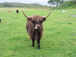
Borrodale was far smaller than I had expected it to be, and seemed to comprise of only a few houses and a series of signs warning people off the land of Borrodale Castle. I met Sam again at the Natural History Centre in Glenmore, which was an attractive building. There was a field full of highland cows next to the centre's car park, and I took some photographs of them for Sam whilst I waited for her to come out. She enjoyed the visitor centre, which was only two pounds fifty pence, and gave a lot of information about the wildlife, history and geology of Ardnamurchan Peninsular.
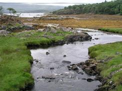
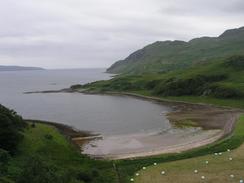
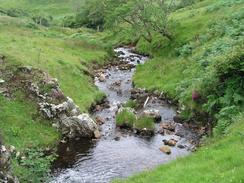
By the time that I reached the car park above the shingle beach of Camas nan Geall I had a choice of routes. I could either walk along the unpathed coast via Maclean's Nose, which is apparently not an easy walk, continue inland along the road for a couple of miles and take a path westwards across moorland, or walk along the road all the way to Kilchoan. I did not fancy the coastal route as it looked quite difficult for little gain; and the road route looked boring and an unnecesary inland diversion. For this reason I decided to do the middle route, and I was very glad that I did this as it proved to be a great moorland walk under the shoulder of Beinn na h-Urchrach. The path was extremely indistinct in places, but the going was good and not too boggy, and the views were superb.
I eventually reached Mervan, which was parked in the car park of the pub at Kichoan. I felt fit enough to walk on for another few miles, but I was content with stopping at the pub for the night. My mood was far more positive than it had been in the morning, and I did not want to do anything that may have endangered this.
In the garden of the pub in Kilchoan there were some tents, and Sam went out to chat to the owners. Apparently they are geology students from Cardiff, and they have spent for weeks mapping a nearby mountain! Living in a tent and tramping around the same mountain for a month may not be my idea of a good life, but they seemed to be enjoying themselves. Sam was curious about why people from Cardiff went all the way to West Scotland to map a mountain, but apparently it is an easy mountain to map.
Directions
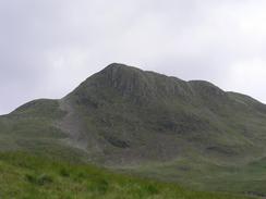
This walk starts off at the car park on the A861 road just above the village of Salen. Walk north along the A861 for a few yards, and then turn down the B8007 road through Salen. The road heads southwestwards along the northern shore of Loch Sunart before turning to head westwards, passing through Glenborrodale and past the Natural History Centre at Glenmore. At the car park above the bay at Camsa nan Geall the road turns to head inland, with the summit of Ben Hiant to the left.
After a couple of miles a path leads off to the left, a few yards beyond a milepost at grid reference NM550641. The path is indistinct and hard to find on the ground, but head uphill to the west - as long as you keep going west, you should be fine. The path is visible in places, and leads towards the edge of a forested area, which it skirts for a short distance before continuing on and descending slowly to meet a track. Follow the track westwards until it skirts and then crosses the Allt Choire Mhuilinn and reaching the B8007 road immediately to the south of the farm at Caim. Turn left and follow the B8007 westwards for a couple of miles until the Kichoan House Hotel is reached, where this walk ends.
Distances
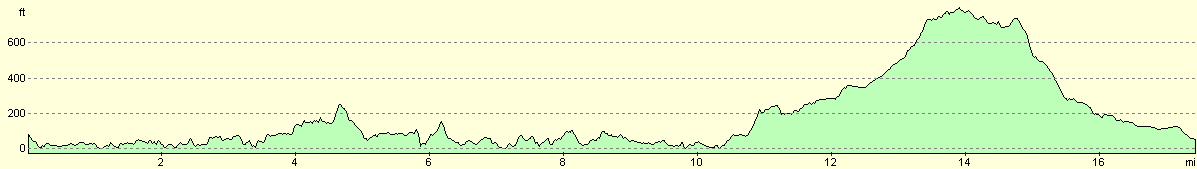
| From | To | Distance (m) | Ascent (ft) | Descent (ft) |
|---|---|---|---|---|
| Salen | Glenborrodale | 7.3 | 1201 | 1234 |
| Glenborrodale | Kilchoan | 10.2 | 1716 | 1706 |
This makes a total distance of 17.5 miles, with 2917 feet of ascent and 2940 feet of descent.
For more information on profiles, ascents and descents, see this page
Accommodation
We parked Mervan in the car park of the Kichoan House Hotel in the village, who were kind enough to let us to park there and use their facilities.
Disclaimer
Please note that I take no responsibility for anything that may happen when following these directions. If you intend to follow this route, then please use the relevant maps and check the route out before you go out. As always when walking, use common sense and you should be fine.
If you find any information on any of these routes that is inaccurate, or you wish to add anything, then please email me.
All images on this site are © of the author. Any reproduction, retransmissions, or republication of all or part of any document found on this site is expressly prohibited, unless the author has explicitly granted its prior written consent to so reproduce, retransmit, or republish the material. All other rights reserved.
Although this site includes links providing convenient direct access to other Internet sites, I do not endorse, approve, certify or make warranties or representations as to the accuracy of the information on these sites.
And finally, enjoy your walking!
This walk was mentioned in the following routes:
| My walk around the coastline of Britain |
Nearby walks
| # | Title | Walk length (miles) |
|---|---|---|
| 493 | Clounlaid to Bunavullin | 20.1 |
| 494 | Bunavullin to Laudale | 24.6 |
| 495 | Laudale to Salen via Strontian | 16.9 |
|
|

|