Walk #497: Kilchoan to Ockle
 |
 |
|
General Data
| Date Walked | 13/07/2003 |
| County | Highlands |
| Start Location | Kilchoan |
| End Location | Ockle |
| Start time | 09.50 |
| End time | 18.22 |
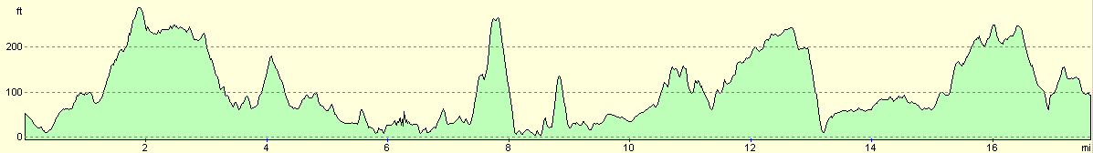
| Distance | 17.7 miles |
| Description | This was a lovely walk, taking in the westernmost point of the British mainland |
| Pack | Today I carried my 30-litre Karrimor HotRock rucksack, which was filled with my packed lunch, waterproof leggings, water bottle and a couple of spare shirts, together with the usual assortment of odds and ends. |
| Condition | I feel absolutely fine after this walk, and have no significant problems to report. My right shoulder was fine again today, which is good. |
| Weather | The forecast for today said it was going to be sunny, but this proved to be wrong, with only occasional sunshine to be seen. The day was mostly cloudy, but there was fortunately no sign of any rain. It was not a warm day, and the strong wind made it quite chilly at times. |
| OS map | Landranger number 47 (Tobermory & North Mull) |
 |
 |
|
 |
 |
|
Map of the walk
Maps courtesy of Google Maps. Route for indicative purposes only, and may have been plotted after the walk. Please let me have comments on what you think of this new format. For a detailed table of timings for this walk, please see the table file.
 |
Notes
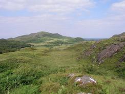
The walk from Kilchoan to Ardnamurchan Point was along the B8007 to Achosnich and then local roads. It was a fairly boring road plod that was enlivened by the views over the surrounding hills. None of the hills were the high, but they were classic examples that hills do not have to be high to make dramatic scenery.
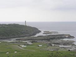
I was most impressed with Ardnamurchan Point. The wind was gusting strongly when I reached there, and Sam was waiting for me in the cafe. The point is the westernmost point of the mainland of Britain, and it is the third cardinal point that I have visited on this trip; the first was the easternmost point at the Ness in Lowestoft, and the second was the Lizard in Cornwall, way back in late January. My last one will be a headland near John O'Groats in five or six week's time.
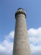
There is a lovely visitors centre in the lighthouse complex. Unfortunately it is not possible to climb up the lighthouse (as I did at the Mull of Galloway), but they have a computer running a virtual view from the top, which can be rotated and panned quite well. The view of the surrounding islands, including Rhum, Eigg and Muck, was superb, and they could also be seen clearly from the base of the lighthouse. There are many interesting displays in the buildings, and you an walk around the machinery in the old plant room. After posing for the obligatory pictures of us standing in front of the foghorn we went back to Mervan so that we could eat our lunch. I had been hoping to be able to walk along the coast to Portuairk, but I could see from the lighthouse that it would be quite a rough route, so instead I walked back to the bridge over the Allt Grigadale, and headed northeastwards from there past Sgurr nam Meann to the village.
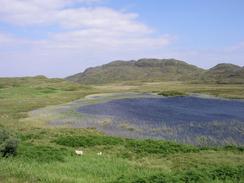
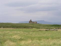
The area between Portuairk to Sanna is dominated by some beautiful sandy beaches, the best beaches that I have seen since Macharahanish near the Mull of Kintyre. The beaches looked lovely and the sands were very white, and gleamed when the sun deigned to make an appearance. In particular the view down over Sanna from the path between the two villages was superb and this whole area has impressed me immensely (although it may be different on a windy and wet winter morning).
From the car park in Sanna I headed eastwards across moorland, and this made for a great, if somewhat boggy, stroll. After a couple of kilometres I met up with a path that lead eastwards across the moorland. The path was indistinct and boggy in places, but it reminded me how much I love moorland walking. My feet also remained dry, despite the boots being fairly saturated on the outside. Eventually I reached the road at Fascadale, which made for quicker walking to the farm at Achateny, where I cut across the moorland eastwards for a short distance to Kilmory. On the way I came across a young stag, its horns short and still covered with fur. It was very close to me, and I sank down onto my knees so that I could observe it more closely. I did not want to frighten its and so I did not go for my camera, but I reached into my fleece pocket and got out my ocular. Through this I could see the stag in great detail, and I was amazed by the view as we looked at each other for a few minutes.
On the way to Ockle I passed a little cottage, outside which several people were sitting. I started chatting to them, and within a minute a glass of wine was in my hands. It turned out that I had landed in the middle of a leaving party for a couple who were moving to Ramsey in Cambridgeshire, not a million miles from where I lived before I started this walk! I felt bad that I was standing around chatting whilst Sam was waiting for me a little over a mile down the road, but her mobile had no reception, and therefore I could not get through to her to invite her up.
It always amazed me how everyone in villages like this know everyone else, and everyone is very friendly. They are going to be getting broadband connections soon, which is quite amazing, considering how long it took friends of mine in Cambridge to get them! Indeed, all telephone connections in this area are broadcast to an ariel and local connections are taken from that, rather than having telephone lines going into the area. After a couple of glasses of wine and nearly an hour I really had to go, and so with regret I said goodbye and left. The views from the cottage were lovely, and I could see myself living there, if only for a few months whilst I do some writing.
I wanted to go back to the little party, but we had an obligation in Ockle, which we could not really to get out of for a few hours, which was a shame. This evening we experimented with my new gas burner, comparing it to my trangia. To boil a saucepan of water took me fifteen minutes on the trangia; boiling the same amount of water on the MSR stove took just a couple of minutes, and was much more controllable. I now know which I am going to take camping with me in a few days! At eight thirty we went the mile up the road to see Michael and Claire, and we ended up parking Mervan in their driveway We eventually left their house at eleven thirty in the evening after a great meal and some superb company. Claire was the local teacher, but they are moving down south to Ramsey to be nearer to her parents. I loved the view from their cottage, from which the surrounding islands and even the Cuillin hills on Skye were clearly visible. I could see myself having a sabbatical in a place like this - the views and atmosphere are almost spiritual.
Directions
This walk starts off at the Kichoan House Hotel in the village of Kilchoan. Head westwards from the hotel, and continue straight on at the road junction by the church until the road forks. Take the right-hand fork, and follow the B8007 as it heads northwestwards for a little over three miles as it passes the Sonachan Hotel and ends at Achosnich. Turn left down another road and follow it beneath Beinn Bhuidhe and past Grigadale until the road ends at the lighthouse at Point of Ardnamurchan.
Head back along the road to the bridge over the Allt Grigadale, where the road curves to the right. Here leave the road and make your way across pathless country northeastwards, aiming to go on the eastward (landward) side of the summit of Sgurr nam Meann before descending to reach the end of the public road at Portuairk. Turn right and head southeastwards along the road until a junctions is met with a track on the left just before the road starts a steep climb uphill. Turn left down this track, and when it soon ends by a cottage continue straight on down a path that climbs over a small hill and crosses a stream. The path then continues on, climbing uphill once more along a distinct track before descending to meet the end of a track behind the dunes of Sanna Bay. Follow this track northeastwards for about a kilometre until it meets the end of a public road in Sanna, by a car park.
From the car park you need to head northeastwards across the pathless moorland, crossing the Allt Sanna and passing to the southeast of a ruined building at Plocaig. From here head on a more easterly course, heading for a little pass between hills to the north and Meall Clach an Daraich to the south. The moorland is frequently boggy, but the views are marvellous. Eventually a metal fence is reached; go through a gate and continue on keeping the large hill to the right and cross the Allt Mhic Cailein. On the eastern side of this a path is met; this is sometimes indistinct but in others it is exceedingly easy to follow as it heads eastwards for a few miles across the moorland, and eventually descends down to meet the end of the road at Fascadale.
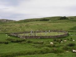
Walk eastwards along the road for a couple of miles until a road junction is reached, and then turn left for a few yards and cross the bridge over the Achateny Burn. On the other side of the bridge continue straight on into a farmyard and then head eastwards across a field for a little under a kilometre until the road is met in Kilmory near a phone box. Join the road and then head eastwards down another road, which passes a burial ground before twisting and turning and eventually reaching the end of the road in Ockle, where this walk ends.
Distances
| From | To | Distance (m) | Ascent (ft) | Descent (ft) |
|---|---|---|---|---|
| Kilchoan | Ardnamurchan Point | 6.3 | 823 | 840 |
| Ardnamurchan Point | Kilmory | 9.2 | 1355 | 1224 |
| KIlmory | Ockle | 2.2 | 285 | 358 |
This makes a total distance of 17.7 miles, with 2463 feet of ascent and 2422 feet of descent.
For more information on profiles, ascents and descents, see this page
Accommodation
We had planned to park Mervan jut off the road at Ockle for the night, which was okay except for the fact that there were not many facilities. In the end, however, we ended up staying outside Michael and Claire's house a mile up the road.
Disclaimer
Please note that I take no responsibility for anything that may happen when following these directions. If you intend to follow this route, then please use the relevant maps and check the route out before you go out. As always when walking, use common sense and you should be fine.
If you find any information on any of these routes that is inaccurate, or you wish to add anything, then please email me.
All images on this site are © of the author. Any reproduction, retransmissions, or republication of all or part of any document found on this site is expressly prohibited, unless the author has explicitly granted its prior written consent to so reproduce, retransmit, or republish the material. All other rights reserved.
Although this site includes links providing convenient direct access to other Internet sites, I do not endorse, approve, certify or make warranties or representations as to the accuracy of the information on these sites.
And finally, enjoy your walking!
This walk was mentioned in the following routes:
| My walk around the coastline of Britain |
Nearby walks
| # | Title | Walk length (miles) |
|---|---|---|
| 494 | Bunavullin to Laudale | 24.6 |
| 496 | Salen to Kilchoan | 17.5 |
|
|

|