Walk #498: Ockle to Glenuig
 |
 |
|
General Data
| Date Walked | 14/07/2003 |
| County | Highlands |
| Start Location | Ockle |
| End Location | Glenuig |
| Start time | 09.28 |
| End time | 17.30 |
| Distance | 21.4 miles |
| Description | A lovely moorland walk was followed by a long road walk, which was made bearable by some lovely views. |
| Pack | Today I carried my 30-litre Karrimor HotRock rucksack, which was filled with my packed lunch, waterproof leggings, water bottle and a couple of spare shirts, together with the usual assortment of odds and ends. |
| Condition | The only problem that I have had today was with my feet, which were aching by the time I reached the pub for lunchtime. Once I had changed into my trainers they were a little better, and I managed to keep a good pace up. For the third day in a row my right shoulder was fine, which is extremely pleasing. |
| Weather | Today was the warmest day for some time, although there was not that much sun and there was a lot of cloud cover. There were a few spots of rain after lunch, and towards the end of the walk it started to rain, but not enough to get me too wet. |
| OS map | Landranger number 47 (Tobermory & North Mull) and Landranger number 40 (Mallaig & Glenfinnan, Loch Shiel) |
 |
 |
|
 |
 |
|
Map of the walk
Maps courtesy of Google Maps. Route for indicative purposes only, and may have been plotted after the walk. Please let me have comments on what you think of this new format. For a detailed table of timings for this walk, please see the table file.
 |
 |
|
Notes
I woke up quite early this morning considering the time that we went to bed last night. I wanted to sleep in for longer, but it was really muggy in the bed and I decided to go down where it is a little cooler. Considering that I had more than a couple of glasses of wine last night I did not feel too bad, and a hangover never reared its ugly head today, for which I am grateful.
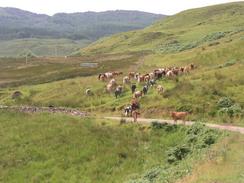
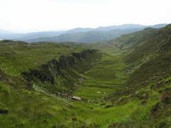
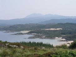
I ended yesterday's walk at Ockle before we drove up the road, and the first mile of today's walk was a short stroll back to Ockle. I seemed to float down the road yesterday, and I found that my muscles were a little more tired this morning before they warmed up. Ockle was quiet, and I chatted to the one lady that I passed in this tiny village before starting the climb uphill along the track that leads to Arivegaig. I really enjoyed this walk, and I stopped occasionally so that I could suck in the views. The track soon became a path that wound its way over the hills, before eventually descending down to skirt a little valley and meeting another track. This was all well and good, but I had to keep moving as there were some large biting insects attacking me. I moved quite fast down the track, but it did not seem to deter them at all, and neither did waving my hat madly around my head! They were extremely annoying, but fortunately when I eventually reached a wooded area I left them behind, with only a few bites on my arms and face.
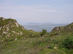
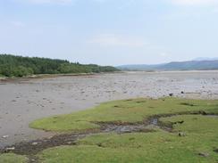
The stretch of track past the southern edge of Kentra Bay was like the M1 after the quiet paths of the last couple of day, with many people walking along to enjoy the little sunshine on the beaches around the bay. One of the beaches near Gortenfern the sand actually 'sings' when it is walked on by bare feet in dry weather - I have visited a similar beach near Philip Island in Australia, and I had planned to divert to visit this one but I totally forgot about it.
By the time that I met Sam at the Clanranald Inn in Mingarrypark I was in need of a drink, and my feet were aching considerably. I did not want any alcohol, so I had a pint of orange and lemonade instead, which was much more refreshing. I could not work out exactly why my feet were aching, as they have not ached in these boots before, but it may have been the long miles of walking along the forestry tracks earlier in the morning. I was very glad to be able to change into my trainers for the rest of the walk, which helped me walk easier.
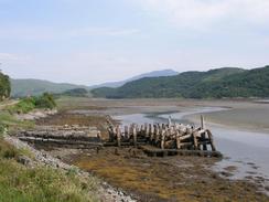
The rest of the route was along the A816 road, which was a fairly boring and uninspiring walk. The highlight was passing the Seven Men of Moidart, seven beech trees planted to commemorate the seven men who landed with Bonnie Prince Charlie in Loch Moidart in 1745. Storms destroyed several of these trees a few years ago, and seven new trees have been planted to replace the original ones.
I was very hungry by the time that I finished the walk, and I was very glad to see the white building of the Glenuig Inn, with the blue of the bay behind it. We had not eaten out for some time, so we decided to go out for a meal instead of eating in Mervan. The food in the Inn was very nice, and I had a lovely steak that filled the gaping hole in my stomach. I had been expecting to like Glenuig and it as a very nice village, but I must admit I did prefer the place where we spent last night - the views were far better. Glenuig has a very healthy community, and many of them had been to the 'T in the park' festival at the weekend. There is a community shop, and many locals take their turn in working in it.
Tomorrow I have a long road plod facing me along the A861 and then the A830(T) to Arisaig, which should be a walk of a little over sixteen miles. The day after that I shall walk north towards Mallaig, and then start the walk along the Loch Morar towards Knoydart. I would really like there to be some nice weather for the next week, as going into Knoydart with torrential weather and low cloud would be far from nice. The weather forecasts, which I religiously watch every morning on television, have been quite depressing over the last week - they have been reporting thirty degrees plus and sunshine over most of the country, but we have seen little if any of this.
Directions
This walk starts off at the bridge over the Allt Ockle in the village of Ockle (I actually started a mile west on the road, and walked down to the start point). When the road ends on the eastern side of the bridge there is a t-junction; turn left up a track, and then turn to the right up another track that passes a cottage. This track heads eastwards for a couple of kilometres, and when a gate is reached at a hairpin bend take a path that heads off to the right. This part is very distinct on the ground and is quite easy to follow, and the ground was not too boggy hen I walked across it.
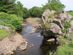
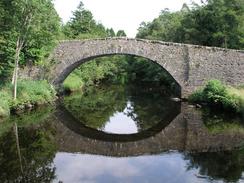
The path doubles back on itself once it crosses the Allt Eilagadale, before heading southeastwards to a summit and descending down to join a track. This track heads southeastwards and enters a forestry area, which it eventually emerges out of at Gorteneorn by the shore of Kentra Bay. A bridge takes you over the Allt Eas an Taileir, and the track continues on for over a mile until it ends at a car park by the end of the public road in Arivegaig. Head straight on along the road which crosses the Dig Bhan on a new bridge before ending at a T-junction with the B8044 road. At the junction turn to the right and walk eastwards for a short distance along the B8044 road until it ends at a junction with the A861 road in Acharacle.
Turn left and follow the A861 road as it heads north to a bridge over the River Sheil, after which it turns to the right through Mingarrypark and Dalnabreck and Langal. It then heads northwards over a hill to Ardmolich, and the heads along the western shore of Loch Moidart and passes the Seven Men of Moidart before climbing uphill to the north and descend into Glenuig. This walk end at the Glenuig Inn, about a hundred yards away to the left in the village.
Distances
| From | To | Distance (m) | Ascent (ft) | Descent (ft) |
|---|---|---|---|---|
| Coldstream | Ockle | 1.3 | 121 | 272 |
| Ockle | Mingarry | 10.8 | 1827 | 1873 |
| Mingarry | Glenuig | 9.3 | 1565 | 1601 |
This makes a total distance of 21.4 miles, with 3513 feet of ascent and 3746 feet of descent.
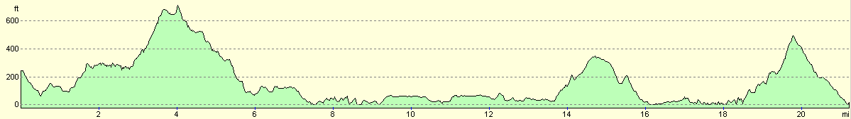
For more information on profiles, ascents and descents, see this page
Accommodation
We parked for the night in the car park of the Glenuig Inn in Glenuig, who were kind enough to let us stay in the car park. This allowed us to use the pub's facilities, and we did so in copious quantities.
Disclaimer
Please note that I take no responsibility for anything that may happen when following these directions. If you intend to follow this route, then please use the relevant maps and check the route out before you go out. As always when walking, use common sense and you should be fine.
If you find any information on any of these routes that is inaccurate, or you wish to add anything, then please email me.
All images on this site are © of the author. Any reproduction, retransmissions, or republication of all or part of any document found on this site is expressly prohibited, unless the author has explicitly granted its prior written consent to so reproduce, retransmit, or republish the material. All other rights reserved.
Although this site includes links providing convenient direct access to other Internet sites, I do not endorse, approve, certify or make warranties or representations as to the accuracy of the information on these sites.
And finally, enjoy your walking!
This walk was mentioned in the following routes:
| My walk around the coastline of Britain |
Nearby walks
| # | Title | Walk length (miles) |
|---|---|---|
| 494 | Bunavullin to Laudale | 24.6 |
| 495 | Laudale to Salen via Strontian | 16.9 |
| 496 | Salen to Kilchoan | 17.5 |
|
|

|