Walk #897: A circular walk between Uttoxeter and Denstone
 |
 |
|
General Data
| Date Walked | 23/04/2011 |
| County | Staffordshire, Derbyshire |
| Start Location | Uttoxeter |
| End Location | Uttoxeter |
| Start time | 08.16 |
| End time | 16.56 |
| Distance | 20.9 miles |
| Description | This was a pleasant stroll around the fields to the north of Uttoxeter. |
| Pack | Today I carried my 30-litre Karrimor rucksack, filled with water, my waterproofs, a couple of books and other odds and ends. |
| Condition | I suffered in the heat today, and I was slightly overheated well before the end of the stroll. I have a little blister on one of my toes, but aside from that I fee fine. |
| Weather | Today was a blisteringly hot day, more akin to something you expect in July than April. There was scarcely a cloud in the sky, although a cooling breeze did start towards the end of the day. |
| OS map | Landranger number 128 (Derby & Burton upon Trent) |
 |
 |
|
Map of the walk
Maps courtesy of Google Maps. Route for indicative purposes only, and may have been plotted after the walk. Please let me have comments on what you think of this new format. For a detailed table of timings for this walk, please see the table file.
 |
 |
|
Notes
This was always going to be an unusual walk - my sister had entered herself and some friends in a charity walk organised by Uttoxeter Lions. She asked me if I wanted to come along, and as I had been a member of Leos, the junior version of the Lions, two decades before, and so it seemed like a good idea to help them out in a small way once more. Since the forecast was for unseasonably warm weather, Sencan decided she would come along on the stroll.
My dad dropped me off outside Wilfred House in the centre of Uttoxeter just before eight, and we went in to register. My sister, Sue, and her friends Clare and Kath joined us later. The room was filling up with people who could easily be split into two groups - walkers and runners. The presence of the latter was explained by the fact that the event was allied to the LDWA.
I have a somewhat cautious impression of the LDWA; the two parts of walking and competitive running seem to be utterly incompatible. Basically, there seems to be no real organisation for walkers such as me: the Ramblers is about short, one-day walks; the MBA is for people who get out into the wilds more whilst I spend much of my time in lowland areas; and the Backpackers' is for people who do long backpacking trips, where most of my walks are single-day affairs. Perhaps it is time for a Trailwalkers' association, for people who are doing long multi-day or single-day walks.
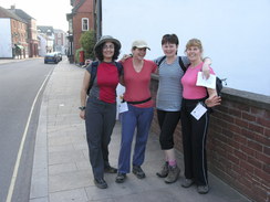
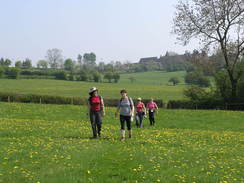
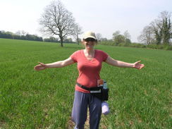
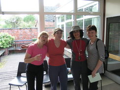
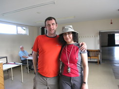
Five happy, fit people strode out of Wilfred House, stopping only to take a 'before' photo, to be compared with an 'after' photo later. In nearly 900 walks I had only ever walked with one other person at a time, so it felt strange to be stepping out with four other people, two of whom were strangers.
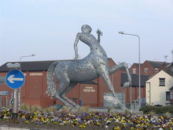
Last week I had attempted to trace the route description on a map, and although I had succeeded with the first half of the route, I had been less successful with the second half. We walked out of the town past a brand-new sculpture of a satyr and passed the station and the racecourse to reach the floodplain of the River Dove. The burners of a bright red hot-air balloon ripped through the air, and we all looked up to watch it glide past, seemingly perilously low to some power lines.
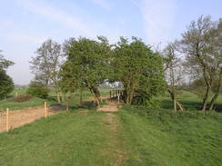
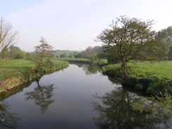
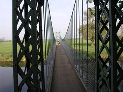
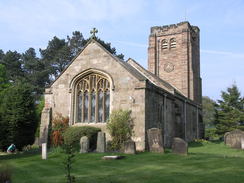
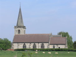
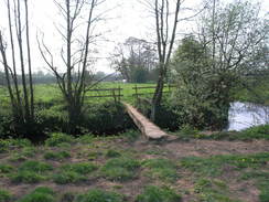
The dry weather meant that all the paths were dry underfoot, and we made good time towards the bridge that carries the A50 over the River Dove. A few late-starting runners roared past us, and we realised that walkers would be in the minority on this walk. From here I was on terrain that I knew well, and we followed a narrow line of banking to the elegant suspension bridge over the Dove. This led us up the hill to the church, which is dominated by an ancient church. A short stroll then took us down to the first checkpoint at the old well.
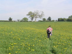
We spurned the opportunity to visit my parents' house nearby and crossed the A50 to follow footpaths towards the next checkpoint in Marston Montgomery. The runners ahead of us had neatly depressed the luscious green grass meaning that navigation was easy; we just had to follow the trail of flattened grass. It descended to cross a stream before climbing up the other side to reach Somersal Herbet church.
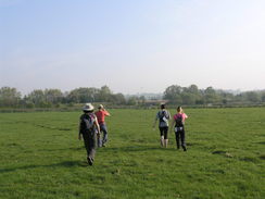
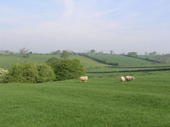
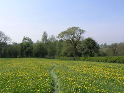
Another path took us north for nearly two miles, and we chatted as we walked. Some of the high points gave us expansive views over the Dove Valley to the west, although sadly these were somewhat spoilt by the hazy sky, a sign of the weeks without rain. We found the second checkpoint at Somersal Herbert with little trouble and greedily drunk the water on offer. It had not been a cold morning when we had set off and it had only got hotter; the signs were that it was going to be a scorcher.
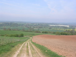
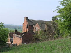
More paths took us west, descending down across fields towards the Staffordshire Way at the ruined Sedsall Farm. I knew this area like the back of my hand, and it felt great to be walking over such familiar territory. I have always had a soft spot for the farm at Sedsall, and it was a shame to see how it had decayed over the past few years; there were more holes in the roof and the fabric of the structure was decaying further. I would love to be able to buy the place to renovate it, but alas that would never be.
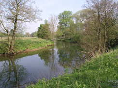
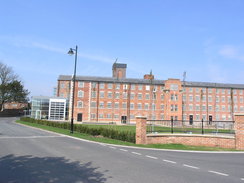
The Staffordshire Way took us north, flirting indelicately with the Dove whilst it crossed the grounds of Abbotsholme School. This led us on to Rocester Bridge, where we said goodbye to the Dove and headed into Rocester. On the way we passed Arkwright's Tutbury Mill, built in 1781. I was surprised to see that this was now an academy school run by JCB; a company that dominates the local area. The mill had been very tastefully restored, and the glass additions to the front and side seemed to complement the structure.
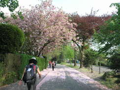
A quick stroll further on and we reached the third checkpoint at the new market cross in the centre of the village. My memories of Rocester were of a rather unkempt centre of the village, complete with ugly concrete flats. These had now all been replaced, with no small thanks due to JCB's money, with neat housing replacing the flats. We stopped at the checkpoint to visit the shops - I bought a couple of ice creams to try to keep my core temperature down; it was already a scorching hot day.
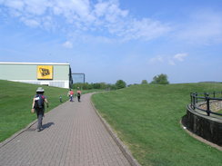
Roads took us across the River Churnet towards the carefully-landscaped grounds that surround the JCB World Headquarters. Once a cheese factory, the factory has expanded into a surprisingly beautiful area. An old railway junction has been totally subsumed, part of the embankment now forming a helicopter landing pad and the rest now lakes. We walked past fishermen - hardly a usual sight right outside a large factory - and then towards a school. I must admit to loving JCB; not only did I go to a couple of product launches in the late seventies and early eighties (complete with smoke and laser display, stunning effects to a young child), but whilst at primary school also made a model JCB out of cardboard. This was seen by someone who worked at the factory, and was put on display in their reception area!
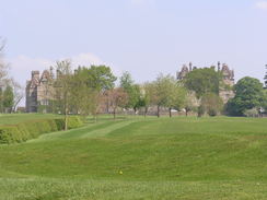
I went to school at Denstone College for five years, and therefore I was back in terrain that I knew well. After crossing a bridge over the old railway line a short stretch of path led to Stubwood and then via more tracks and paths to Riddings and the Denstone College Golf Course. The path skirted the bottom of the course, passing the old outdoor swimming pool that had thankfully been made redundant by a heated indoor pool by the time I attended the school.
Here we had a strange event. The organisers had given us written notes describing the route to take, and Sue and her friends had applied months before. I had only applied in the last fortnight and had just received the notes. It led to a conversation something like this:
"It says we should go fifteen yards past a bench."
"No it doesn't."
"Yes it does!"
"Look, there are people heading in the direction my notes say!"
"But the notes mention the bench, look!"
A quick comparison of the notes showed that, indeed, they were different. In the end we followed my notes as they were the more recent and I had marked the route on my map. The heat was really starting to get to all of us now, and even I was starting to wilt under the sun's assault, despite having easily managed two twenty miles walk earlier in the week.
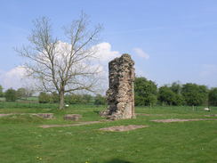
After meeting a road a lovely stretch of footpath headed westwards along a little ridge, with hazy views to the north over Alton. We left this track and descended to reach Croxden Abbey. This Cistercian Abbey was completed in 1253, but slowly subsided before being surrendered in 1538. I have always been found of the ruins, and especially of the one-piece stone coffins that can be found scattered around. It was somewhat fitting that the fourth checkpoint was here, and we greedily drunk the offered water before sitting down in the shade of the tall stone walls. I took my boots off to allow my feet to cool down, and we did some running repairs to one of Sencan's little toenails, which had split.
We started going slower as the heat and distance started to get the better of us. It proved easy to follow the paths southeast from the abbey, but the route south from here as the route notes became increasingly indistinct and the fields smaller. We met two older walkers, one of whom had done the walk twice before but they also seemed to be similarly confused. Eventually we reached the last checkpoint in Stramshall, and it turned out that we had come from the wrong direction.
It would have been nice to have a little break at the checkpoint, but we were aware that there was a set time that we had to finish the walk by. I often manage a twenty mile walk in seven hours, but this one was just dragging on, not the least due to the heat. A good track took us south towards the small River Tean, after which we followed the route of the old Uttoxeter Canal for a short distance. This canal closed in 1849 when the Uttoxeter to Macclesfield railway line used part of the route in the Churnet Valley. Despite having closed so long ago the banks and bed were still clearly visible in places.
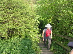
A bridge with rickety handrails took us over the Tean and towards a long flight of steps to a road bridge over the A50, whose noise had been intruding for the last half-hour. After passing a pub - to which I gave longing looks - the path climbed to a farm before descending down along tracks to reach a main road to the west of Uttoxeter. From here it was a simple walk towards the end of the walk back at Wilfred House.
We arrived five weary and footsore - if happy - walkers, not quite the last to complete the stroll. Apparently the first people had arrived back after just four hours, and although that would have been a punishing pace they would also have avoided the worst of the heat. Still, it was good to get the completer's certificates and a cup of soup before waiting for our lift back home. It had been a good day, and the company friendly enough for me to want to do it again. Still, I think that my solo walks are not yet at an end...
Many thanks to the guys and gals at Uttoxeter Leos for organising this walk, which is held every Easter and is well worth a go.
 |
 |
|
Directions
This walk starts off at Wilfred House in Uttoxeter, at SK090334. Turn right outside Wilfred House to head east along Carter Street; when this ends turn right into Market Place and follow this as it curves to the left to reach the War Memorial, then turn right into Bridge Street. At a roundabout carefully cross the A518 and continue eastwards along Brookside Road, heading past the railway station. When the road ends at a green metal fence, take a small gate to the right and join the Staffordshire way through gate. Follow a broad track eastwards; it soon curves to the left, keeping some modern industrial buildings on the left. Cross a stile and head northeastwards across a field, aiming to keep The Willows farm on the right. Cross a stile and turn right to join a track; follow the hedge on the left to a stile and follow the path across a field northwards towards a pylon then to two stiles across a rough track to reach a surfaced cycle path at SK104343.
Turn right to follow the cycle path wastwards; leave it almost immediately and follow a hedge on the right to reach a stile in the corner. Cross this into a field and follow a path on top of flood bank southeastwards with the River Dove to the left. After nearly half a mile a suspension bridge over the river is reached. Cross this and continue along the path as it crosses an old mill leat to end at Mill Lane. Head straight on uphill, keeping the churchyard on the left to reach a T-junction with Doveridge church on the left at SK113341.
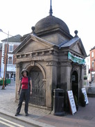
Turn right and head down Church Lane to reach an old covered well; now a seating area. Turn left to head up a slight hill along Cook Lane; when this road ends at a T-junction with Derby Road beside the Cavendish Arms, turn right for 250 yards along Derby Lane until a roundabout is reached. Turn left at the roundabout to head along Marston Lane and cross the A50 on a bridge. Shortly after the bridge turn right up a private road; this immediately curves to the left. Keep a farm on the right; at a gate cross a stile on the left to run in a gap between fences with the driveway and farm on the right; the gap between the fences is planted with regular trees. At the other end cross a stile and enter a field, keeping a hedge and the track on the right. Head down the field and go through a gate at the bottom to enter a second field. Continue on to the stream at the bottom of the field, and then turn left for about fifty yards to reach a footbridge over the stream on the right. Cross this bridge and continue up the next field, aiming for a stile through a hedge. Continue straight on across the next field, aiming immediately to the left of Somersal Herbert church.
Cross a stile and turn right down a lane, passing Somersal Herbert Hall on the right, and then turn left to cross a stile beside a metal gate to join another path. This heads uphill to the north-northwest; keep Somersal Farm on the left and follow the path as it curves to take a more northerly course. It goes through a hedge and crosses a track at SK134358; continue straight on with a hedge on the right and descend down to a footbridge over a stream. Cross the bridge and continue uphill with a hedge on the right; skirt Old Woodhouse Farm on the right and continue downhill across the field, aiming for the bottom right-hand corner.
Cross a stream at the bottom and continue northwards uphill. Near the top go through another two stiles in hedges and continue northwards downhill, joining a hedge on the left before crossing a footbridge over another stream. The path continues uphill towards the top left-hand corner where there is a stile that leads out onto Wadley Lane in Marston Montgomery. Turn right up the road for a short distance, and then left to reach a T-junction opposite the Manor House at SK134378.
Continue along the road northwestwards; at a signpost turn left along a track for a few yards towards a house on the left, and then turn right past a gate to enter a field. Head southwestwards across this field to another stile and head on in the same direction in a second field. Just before the bottom of this, turn right into a small wooded area and pass a depression on the left. Leave the woodland and head downhill in a rough westerly direction; pass a pond on the left to cross a stream on a footbridge at the bottom and climb westwards for a short distance up the next field, looking for a stile in the hedge on the left.
Cross this and turn left to head south-southwestwards across a field. On the other side turn partially to the right to head westwards across another field . Cross a stile and head to a footbridge across a small stream halfway down the hedge on the left. Cross this and head south across the field, and then turn right, keeping the hedge on the left. Finally cross another stile and a field to reach a road opposite Havenhouse Farm.
Cross the road and continue in a rough westerly direction for a third of a mile along a track, passing a pond on the left; just before it reaches Eaton Barn turn left along the track, keeping the buildings on the right. Immediately after the last building turn right across a stile into a small area of scrubland; head diagonally across this to reach the far left-hand corner. Cross another stile to enter a large field with grand views down into the Dove Valley. Head down this field to the northwest, paralleling the track on the left; at the bottom cross a stile and turn left to another stile and then rejoin the track. Head downhill to the southwest along this track; pass a cottage on the left, and then just before the ruined farm at Sedsall is reached turn right along a footpath. This climbs into a little copse immediately above Sedsall, before descending to join the Staffordshire Way at SK109377.
Head along the track as it skirts the hillside northestwards; after about half a mile the Staffordshire Way curves to take a north-northeastwards course with the River Dove to the left. At a loop in the river the trail cuts straight across a school playing field to the west of Abbotsholme School before rejoining the riverbank and following it northwards across fields towards Rocester Bridge. Climb up the steps to the road and then turn left to cross the bridge over the River Dove, and continue on past Arkwrights mill (now the JCB Academy) to reach the market cross in the centre of Rocester.
Bear left with the Red Lion on the right; there is a pavement on the right. Use a footbridge to cross the River Churnet, with a road bridge immediately on the left. On the other side of the bridge pass under the B5030 using an underpass. Bear right on surfaced path to pass in front of the JCB World Headquarters; after a third of a mile this becomes a public road that heads northwards for a fifth of a mile, passing the Ryecroft School on the right. When a roundabout is reached take the second exit to walk up a narrow lane, crossing a bridge over an old railway line. At a T-junction turn right up Oak Road, and after 100 yards (just before a right-hand bend) turn left through a clapper gate to enter a field. Head southwestwards up the field for a couple of hundred yards before exiting the field and reaching a road in Stubwood next to a bench.
Turn right and follow the road southwestwards for a sixth of a mile; pass a phone box on the right and then turn right across a stile to join a footpath that is signposted for Denstone College. Keep a hedge on the right; after another stile turn half-left to parallel a hedge on the left. Cross another couple of stiles to meet a farm track; turn left to follow the track downhill; at a white gate turn right along the track and follow it as it passes to the north of Riddings. Go through a series of gates and stiles; at a small circular enclosure turn half-left across a field, crossing a stile and reaching another farm track. Turn right then shortly through gate on left, and ahead to a stile in the far left-hand corner of the field, then bear left to a stile in the bottom corner of a field. Cross this to enter Denstone College Golf Course. Head northnorthwestwards across the golf course, paralleling the stream to the left; just before the course ends and a few yards past a bench, turn right to reach a stile through the hedge. On the other side turn left and cross a series of stiles with the stream a little distance to the left. The footpath reaches Nabb Lane at SK081404.
Turn left to head south along the lane. After 300 yards turn right along a track. Continue through several gates for a little over a mile westwards until a junction with a footpath is reached at SK064403. Turn left to head south along the footpath downhill with a hedge on the left; about halfway down cross a stile through the hedge and turn right, heading downhill with the hedge on the right. At the bottom of the field go through a gate to join a road; continue straight on down this, passing Croxden Church on the left before reaching Croxden Abbey.
Turn around and head back up the road past the church to reach the gate. Go through this and immediately turn to the right to head east-southeastwards with a hedge on the right. Cross a couple of fields and stiles to reach a farm track; cross this and continue on, still with the hedge on the right. When the hedge on the right ends, continue on across a field to reach a farm track at SK074390. Continue southeastwards along the track for about 200 yards; just before it curves to the right turn left to a stile and follow the path across a field to reach a road that follows the course of an old Roman Road. Turn left to follow the road eastwards for a couple of hundred yards; when a stile is reached beside a gate on the right, cross it to enter a field. Keep the hedge on the left as the path heads down the field to a footbridge. Cross this and head south diagonally across a field to that leads to a farm track at SK077382. Join the track and follow it as it winds in a rough southerly direction for a little under half a mile until a junction is reached at SK078376, immediately to the east of Nothill Farm.
Turn left and follow a track for a third of a mile until a junction with Hook Lane is reached at SK081372. Turn right along track, passing Larkrise Farm on the left. When the hedge on the left ends, turn left and head south across fields a couple of fields to reach a footbridge over a stream. Cross this and heads south across the field; cross a stile and on other side follow hedge on the right to another stile. On the other side turn left along a rough, overgrown path that runs between hedges until it ends at another stile.
Go right to another stile and turn left down a field, keeping a hedge a few yards away to the right. At the end of the field cross a stile and footbridge on right. Go ahead to footbridge and stile then cross more stiles. As some gardens and houses are reached, turn right to head west-southwestwards a field corner; it squeezes between houses before ending at Hollington Lane. Turn left down Hollington Lane for a short distance, and when this road ends at a T-junction turn left to head southeastwards towards the pub in Stramshall.
Before the pub is reached turn right down Vicarage Drive; as this curves to the right head straight on along a track. Initially this heads between farm buildings before continuing downhill for a third of a mile before ending at a gate. Pass this and enter a field; continue on downhill to the south and before the hedge on the right jinks, turn right across a stile next to a metal gate. Head westwards across the next field with the course of the old Uttoxeter Canal immediately on the left. When the hedges end continue across a field to reach a narrow footbridge over the River Tean. On the other side of the bridge turn left to head south-southwestwards across a field to reach the foot of a road embankment. Climb up a flight of steps to reach the A552 road; carefully cross it to reach a pavement and then turn left to cross the A50 dual carriageway via the road bridge. Immediately on the other side of the bridge turn right into the driveway leading to The Parks Brasserie and Bar. Before the car park is reached turn left down some steps. Cross a stile and follow a path through a copse to reach Fradley Grove.
Turn left and then almost immediately right into Tunnicliffe Way. When it ends cross a stile on the left and walk up the field west-southwestwards; join a hedge on the left, and then go through a stile on the left to enter an area of rough ground. Cross this and another stile to enter the farmyard at Moss Beds. Join the farm track and turn right and then left along farm track through several gates and past Park Fields to reach a stile on the left. Cross the field to a stile in the corner and use this to access a road at SK073338. Turn left and follow the road eastwards, and then turn right through gates into Bramshall Road Park. Follow the path south through the park until the Picknal Brook is reached, and then turn left to follow the stream eastwards. A bridge over the brook transfers the path to the southern bank, and another returns it to the northern bank. After a third of a mile the path ends at the B5027; turn left to follow this road northeastwards and then turn right to a road. Continue up this road as it curves to the right, becoming Carter Street as it heads towards Wilfred House.
 |
 |
|
Distances
| From | To | Distance (m) | Ascent (ft) | Descent (ft) |
|---|---|---|---|---|
| Uttoxeter | Somersal Herbert | 4.0 | 200 | 148 |
| Somersal Herbert | Rocester | 5.3 | 466 | 502 |
| Rocester | Croxden Abbey | 4.5 | 430 | 292 |
| >Croxden Abbey | Uttoxeter | 7.1 | 315 | 469 |
This makes a total distance of 20.9 miles, with 1411 feet of ascent and 1411 feet of descent.
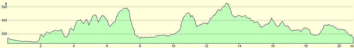
For more information on profiles, ascents and descents, see this page
 |
 |
|
 |
 |
|
 |
 |
|
 |
 |
|
 |
 |
|
 |
 |
|
 |
 |
|
 |
 |
|
 |
 |
|
 |
 |
|
 |
 |
|
 |
 |
|
 |
 |
|
Disclaimer
Please note that I take no responsibility for anything that may happen when following these directions. If you intend to follow this route, then please use the relevant maps and check the route out before you go out. As always when walking, use common sense and you should be fine.
If you find any information on any of these routes that is inaccurate, or you wish to add anything, then please email me.
All images on this site are © of the author. Any reproduction, retransmissions, or republication of all or part of any document found on this site is expressly prohibited, unless the author has explicitly granted its prior written consent to so reproduce, retransmit, or republish the material. All other rights reserved.
Although this site includes links providing convenient direct access to other Internet sites, I do not endorse, approve, certify or make warranties or representations as to the accuracy of the information on these sites.
And finally, enjoy your walking!
Nearby walks
| # | Title | Walk length (miles) |
|---|---|---|
| 24 | The Weaver Hills | 6.0 |
| 68 | Willington to Doveridge | 12.6 |
| 69 | Doveridge to Thorpe | 14.9 |
|
|

|