Walk #696: Brentwood to Hatfield Peverel
 |
 |
|
General Data
| Date Walked | 13/11/2005 |
| County | Essex |
| Start Location | Brentwood station |
| End Location | Hatfield Peverel station |
| Start time | 08.24 |
| End time | 16.02 |
| Distance | 20.7 miles |
| Description | This was a long and straightforward road walk, through surprisingly interesting villages along the old Roman London to Colchester road. |
| Pack | Today I carried my 30-litre Karrimor rucksack filled with my waterproofs, a book and various other odds and ends. |
| Condition | My knees, which ached throughout yesterday's walk, gave me no trouble today, and indeed I got through the entire day with no significant pain or problems. |
| Weather | The forecast for today was for sunshine, and I was disappointed when I was greeted by cloudy skies. As the day went on these slowly lifted, although they never totally cleared. It was a cold day, and the sun never really got around to warming me up. |
| OS map | Landranger number 177 (East London, Billericay & Gravesend) and Landranger number 167 (Chelmsford, Harlow & Bishop's Stortford) |
 |
 |
|
 |
 |
|
Map of the walk
Maps courtesy of Google Maps. Route for indicative purposes only, and may have been plotted after the walk. Please let me have comments on what you think of this new format. For a detailed table of timings for this walk, please see the table file.
 |
Notes
Before I say anything else, it must be admitted that this is not what anyone would call classic walking territory. Essex is not a county that many people go to walk in, and of they do they probably stick to the more scenic areas, such as the Essex marshes or Epping Forest. However I have done many walks in Essex in the past, and my map of the county has a large gap running through the centre of it. An obvious route for me to walk is along the A12, and as this promised to be a flat walk, and I am still suffering from problems with my knees, it looked like an ideal walk to do. I therefore set out from Cambridge, and a little over an hour later I pulled up at Brentwood railway station.
It was a relief to find that car parking was free on a Sunday, and so I parked my car, threw my rucksack on and started walking through the town. The first thing of note was St Thomas Church in the centre of the town; built of flint, it was an extremely pleasant church to look at and is relatively modern, having been built in 1835 on the site of a thirteenth century church. Unfortunately there was not much else to look at as I followed the A1023 northeastwards out of the town; it was a sleepy place on this Sunday morning, and as I strode along the cycle path beside the road only one cyclist came past me.
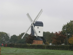
I crossed the A12(T) via a large roundabout, and, after stopping to photograph a burnt-out house nearby, continued on into the little village of Mountnessing. This was a pretty little village, and I enjoyed the views I got of the 1807-built post windmill, set beside a series of playing fields, which by this time were full of children playing football. Eventually the noise of the A12(T) intruded once more, and I used an underpass to cross under it to reach Heybridge. A road led me back to the B1002, and I followed this through Ingatestone, where I used the opportunity to buy some chocolate and a packet of crisps, as I had forgotten to bring my usual nuts and raisins with me to eat.
On the road between Ingatestone and Margaretting a couple of pony and traps passed me, turned around, and trotted off down the road again. This was repeated, and on the second occasion there was a little traffic snarl up as cars could not pass the traps, which were running side by side. It made for a pleasant sight, and made an otherwise dull stretch of road walking interesting. I reached a crossroads in Margaretting at exactly eleven o'clock, in time to see a remembrance service going on at the war memorial. I hesitated for a couple of minutes with my head bowed, until a bugle played the last post and I was awoken from my thoughts. The road took me under a railway line, and then on to a bridge over the River Wid and the A12. Immediately after this bridge a bridleway led off to the right, and as it looked like an easier walk than the road I decided to take it.
I was immediately passed by a horse and rider, and as the bridleway led up towards Galleywood Common I got some pleasant views, the first (and only) scenic views that I would get all day. The bridleway ended at a road, and I crossed this to continue on across the common to Galleywood Church. This looked like a fine building, but I could not get a good photograph of it because of the adjacent trees and a stream of worshippers coming out from a service, and so I abandoned any thoughts of capturing it on film and headed along a track back to the B1007 road. This road took me northwards towards the centre of Chlemsford; however, before the centre was reached I joined local roads that took me past a factory with a blue plaque on it, announcing that this was the first radio factory in the world, set up by the Marconi Telegraph co. in 1899. It remained in Marconi hands until 2003, when that companies travails caused it to reduce in size.
Adjacent to the factory was a dual carriageway, and after crossing this I reached the centre of the ton. I wanted to make my way towards the railway station, and although the map clearly showed roads heading through the centre to the station, some signposts pointed along the banks of the River Can. This was a rather circuitous route, but the initial stretch beside the river was pleasant enough and in fair time I reached the station. Here I was tempted to abandon the day's walk, but I still had plenty of time and so I chose to continue, but first I nipped into the railway Tavern opposite the station for a rest. This was a railway themed pub and had posters and signs up on the walls, but when I asked the landlord he admitted he had no interest in railways, and they were just there because of the pub's name. Slightly deflated I had a point of Abbott, which was slowly followed by a pint of orange and lemonade, before once more I headed off through the town.
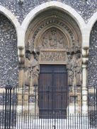
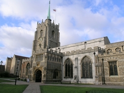
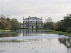
I had deliberately planned my route so that I would pass Chelmsford Cathedral, and this turned out to be a good plan as the cathedral, although small, was a very pleasant building. It is hardly a classic cathedral and is more the size of a city church, and as I took photographs of it I realised that it had lost nothing because of its diminutive size. I left the cathedral with some regrets, and more roads led me out of the city northeastwards. Some of these were quite busy, but once I had crossed the A12(T) in Boreham the road became much quieter. Immediately next to the A12(T) roundabout I passed Boreham House, which was in a magnificent setting, with a long 18th Century formal canal in front of it. Signs warned trespassers away, but I shot some photos through the railings.
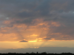
The skies started to darken as I followed the road on, and the sun started to sink away to my left. It was a noisy walk as the A12(T) ran parallel to the A12, but I turned my Walkman on to smother the drone of the cars, and before I knew it I was in Hatfield Peverel. There was an old-fashioned post box in a wall in the village, and once I passed the church I walked down the road that led to the railway station. Unfortunately it turned out that I had misread the train times when I was at home and I had a long, fifty-minute wait for the first train, but the beautiful sunset somewhat compensated for this chilly wait.
Directions
This walk starts off at Brentwood railway station. Leave the station and turn right to walk past some car parking paces, before the road curves to the left to head uphill.. Ignore the first road off to the left and take the second, Gresham Road, until this ends at the B186 road. Turn right to head uphill for a few yards to a roundabout, and then turn right up the B186 Queen's Road, which leads through Brentwood. When Alfred road is reached on the left, turn left down it and walk towards St Thomas Church, and then past it to reach the A1023 High Street.
Once at the A1023 turn right and start following it as it heads northeastwards out of Brentwood; it soon enters Shenfield and carries on for a couple of miles until a large roundabout is reached over the A12. Carefully cross this roundabout, and on the other side continue straight on along the B1002 northeastwards through Mountnessing. The road leaves the village and approaches the A2; when it curves to the left away from the main road head under an underpass to the right that leads under the A12. At a road on the other side turn left and follow a road northeastwards; when this reaches another junction continue straight on along the B1002 once more.
The B1002 heads through Ingatestone and parallels the A12 for a period before reaching Margaretting. At a crossroads in the village by a war memorial turn right, and follow a road that curves around before heading under a railway line. The road heads on past Durrant's Farm and over the River Wid before crossing the A12 on a high bridge. on the other side of this bridge a bridleway leads off to the right; take this bridleway as it heads uphill with a patch of woodland to the left. The bridleway curves slightly to the right and then the left as it climbs, and when it reaches a T-junction with another bridleway turn left and follow it northwards for a hundred yards until it merges at a road.
Follow this road northeastwards until it reaches a crossroads with the B1007 road, and then turn left to start heading north along the B1007; after about a mile when the road turns sharply to the left continue straight on downhill along Longstomps Avenue. When this ends cross the A1114 and head straight on down Vicarage Road. This curves slowly to the right, and when this ends at a T-junction turn right and then immediately left, to head up Mildmay Road. When this ends at the A1060 turn left along the road for a short distance to a pedestrian crossing, and cross the road using this. On the other side head up the pedestrianised High Street, and once a bridge over the river Can is reached turn left and walk along the northern bank. This becomes Bellmead road, and before this reaches a roundabout turn right and follow the A1099 road until Duke Street heads off to the let, Chelmsford station is a short distance down this road.
from the station head back up Duke Street towards the Cathedral, and from there head up Waterloo Lane until this ends near a leisure centre by the River Chelmer. Turn left to follow the road northwards to the A1099 Victoria Road, and then turn right to follow the road eastwards until it ends at a junction with the B1137 Springfield Road. Turn left and follow this road as it heads northeastwards through Chelmsford, passing the prison. Head straight over the first roundabout, and then at the second turn right to pass under the A138, and then at a roundabout turn left to head northeastwards. Cross over another couple of roundabouts until the road rises up to a large roundabout over the A12.
Turn right to cross the A12, and then at the next roundabout turn left to start following the B1137 as it heads northeastwards through Boreham, skirting the A12 and heading on into Hatfield Peverel. The road climbs up to pas the church, and then turn left to head down Station road to reach Hatfield Peverel railway station, where this walk ends.
Distances
| From | To | Distance (m) | Ascent (ft) | Descent (ft) |
|---|---|---|---|---|
| Brentwood station | Ingatestone | 6.1 | 243 | 282 |
| Ingatestone | Galleywood | 4.6 | 240 | 194 |
| Galleywood | Chelmsford station | 3.0 | 62 | 226 |
| Chelmsford station | Hatfield Peverel station | 7.0 | 259 | 230 |
This makes a total distance of 20.7 miles, with 804 feet of ascent and 932 feet of descent.
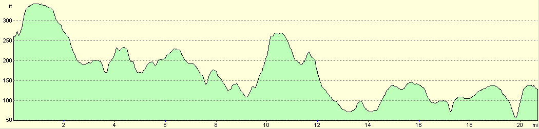
For more information on profiles, ascents and descents, see this page
Transport
There are regular train services running between Hatfiled Peverel, Chelmsford and Brentwood; however, on many of these you have to change at Shenfield station to reach Brentwood.
Disclaimer
Please note that I take no responsibility for anything that may happen when following these directions. If you intend to follow this route, then please use the relevant maps and check the route out before you go out. As always when walking, use common sense and you should be fine.
If you find any information on any of these routes that is inaccurate, or you wish to add anything, then please email me.
All images on this site are © of the author. Any reproduction, retransmissions, or republication of all or part of any document found on this site is expressly prohibited, unless the author has explicitly granted its prior written consent to so reproduce, retransmit, or republish the material. All other rights reserved.
Although this site includes links providing convenient direct access to other Internet sites, I do not endorse, approve, certify or make warranties or representations as to the accuracy of the information on these sites.
And finally, enjoy your walking!
Nearby walks
| # | Title | Walk length (miles) |
|---|---|---|
| 272 | Tollesbury to Maldon | 17.2 |
| 273 | Maldon to St Lawrence | 16.0 |
| 630 | Braintree to Marks Tey | 14.4 |
|
|

|