Walk #38: Hawes to Keld
 |
 |
|
General Data
| Date Walked | 16/08/1999 |
| County | North Yorkshire |
| Start Location | Hawes YHA |
| End Location | Keld YHA |
| Start time | 08.00 |
| End time | 14.00 |
| Distance | 12.9 miles |
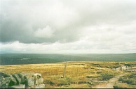
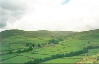
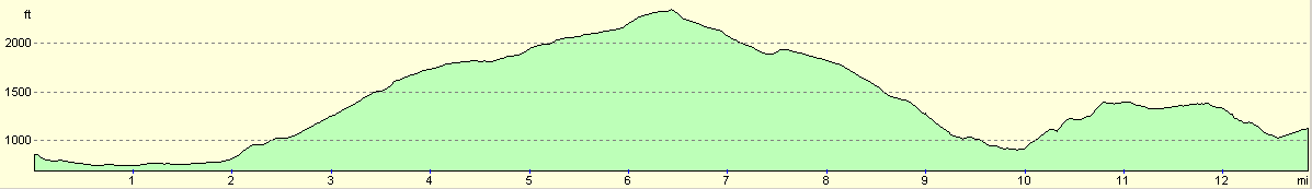
| Description | This is a very nice day's walk, climbing up slowly onto the top of Great Shunner Fell before dropping down into the picturesque village of Thwaite. |
| Pack | Today I carried full camping gear. |
| Condition | I feel absolutely fine after this walk. I made good time all day. My back is fine, my legs are fine and my ankle, though aching slightly, is not hurting. Generally positive. |
| Weather | I wore my t-shirt all the way today. The weather on the early morning climb up to Great Shunner Fell was lovely, with only the wind making it slightly bracing. It remained good all the way down into Thwaite, but after that on the way into Keld it showered and hailed. The sun soon came out again though. I did not even bother to put on my coat and wore my t-shirt continuously. |
| OS map | Outdoor Leisure number 30 (Yorkshire Dales - Northern & Central Areas) |
Map of the walk
Maps courtesy of Google Maps. Route for indicative purposes only, and may have been plotted after the walk. Please let me have comments on what you think of this new format. For a detailed table of timings for this walk, please see the table file.
Notes
This was a very nice days walk. I could do with more days like this. I walked on my own and I slightly missed Sam's company, but nonetheless a nice day. The going on the rocks around Kisdon Hill between Thwaite and Keld was hard and slippery after the rain.
I am feeling much more confident about finishing the walk now. Tomorrow's walk to Baldersdale should no be too hard at about 15 miles, and the only day I am particularly concerned about is the one between Dufton and Garrigill which promises to be a hard one.
Directions
I am not going to bother giving any directions for any of the stages of the Pennine Way; there are many route descriptions produced that will better anything that I could produce. The main guides I used were the OS National Trail Guides, which come complete with strip maps of the route. Click on one of the links below to go to the Amazon page for each guide.
|
| 
|
| |
| |
Distances
| From | To | Distance (m) | Ascent (ft) | Descent (ft) |
|---|---|---|---|---|
| Hawes | Great Shunner Fell | 6.4 | 1693 | 207 |
| Great Shunner Fell | Thwaite | 3.3 | 56 | 1453 |
| Thwaite | Keld | 3.2 | 732 | 561 |
This makes a total distance of 12.9 miles, with 2481 feet of ascent and 2221 feet of descent.
For more information on profiles, ascents and descents, see this page
Disclaimer
Please note that I take no responsibility for anything that may happen when following these directions. If you intend to follow this route, then please use the relevant maps and check the route out before you go out. As always when walking, use common sense and you should be fine.
If you find any information on any of these routes that is inaccurate, or you wish to add anything, then please email me.
All images on this site are © of the author. Any reproduction, retransmissions, or republication of all or part of any document found on this site is expressly prohibited, unless the author has explicitly granted its prior written consent to so reproduce, retransmit, or republish the material. All other rights reserved.
Although this site includes links providing convenient direct access to other Internet sites, I do not endorse, approve, certify or make warranties or representations as to the accuracy of the information on these sites.
And finally, enjoy your walking!
This walk was mentioned in the following routes:
| My sectional Land's End to John O'Groats walk |
| My Pennine Way Walk, 07th to 26th August 1999 |
Nearby walks
| # | Title | Walk length (miles) |
|---|---|---|
| 37 | Horton in Ribbesdale to Hawes | 14.0 |
| 39 | Keld to Baldersdale | 15.0 |
| 658 | Grassington to Swarthgill | 18.0 |
|
|

|