Walk #727: A circular walk from Thistleton to Croxton Kerrial
 |
 |
|
General Data
| Date Walked | 29/05/2006 |
| County | Rutland, Lincolnshire, Leicestershire |
| Start Location | Thistleton church |
| End Location | Thistleton church |
| Start time | 09.35 |
| End time | 18.03 |
| Distance | 23.7 miles |
| Description | This was a mixed stroll, with the fist half consisting of a long stroll along green lanes and the second half being a long road walk. |
| Pack | Today I carried my 30-litre Karrimor rucksack filled with my waterproofs, two litres of water, a book and various other odds and ends. |
| Condition | I feel quite good after this walk; I have had no problem with my knees despite not wearing knee braces. |
| Weather | Today had quite mixed weather, with some sunshine, but also three showers, the last of which was quite heavy and prolonged. It was quite a warm day, and when it was not training I found that I would overheat slightly in my coat. |
| OS map | Landranger number 130 (Grantham, Sleaford & Bourne) |
 |
 |
|
 |
 |
|
Map of the walk
Maps courtesy of Google Maps. Route for indicative purposes only, and may have been plotted after the walk. Please let me have comments on what you think of this new format. For a detailed table of timings for this walk, please see the table file.
 |
 |
|
 |
Notes
After Saturday's walk north through Rutland, I decided to do another walk adjoining this one. From looking at the map there is an obvious route north following the Viking Way, so I settled on a circular walk, following the Viking Way northwards from Thistleton before heading west and following roads back to the start. The journey up to Thistleton proved to be less eventful than Saturday's drive had been, and after driving through the small village twice I settled on parking on the roadside by some houses, a place I had walked past on Saturday's walk.
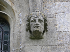
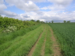
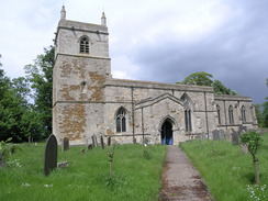
Initially I walked through the village to the church of St Nicholas in the village, a pleasant structure with some fine detailing. I walked around and took some photographs, before joining the Viking way, which left the village and started heading northwestwards. The sun was blazing down at this point, although the weather forecast did not give me much hope for this continuing through the day. The road passed through an old railway embankment, the abutments still being present but the bridge having long gone. Shortly after this a road led off to the left, which was followed by a bridleway that took me north past Crown Point Farm. This bridleway was good to walk on, although a little muddy in places, and it was rutted in places from both tractors and four wheel drives.
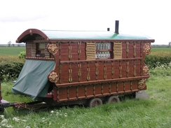
Before the track ended in Sewstern I passed some horses and ponies that were tethered bside the track and, shortly afterwards reaches some caravans, including a traditional gypsy-style caravan. I waved at the occupants, and the track soon ended at a road in the village. Here there were two ladies who enquired if I was checking the route of the Viking Way, and when I said that I was not, they told me that Sewstern Lane was very churned up and muddy - nearly impassable. I assumed that this was the path heading north from Sewstern, so after the recent heavy rain I was expecting to get muddy. There was not much of note in the village, and I soon found myself heading on along a road northwards. This crossed the B676, and another road continued on northwards before ending near to a large water tower.
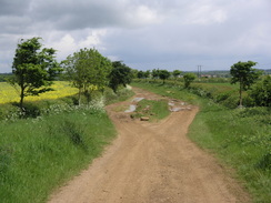
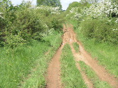
From here a bridleway continued northwards, along a track that was wide and initially quite rutted. Fortunately the width of the track meant that I could avoid the worst of the ruts, and it soon became firmer and less rutted. The path continued on northwestwards, rising and falling slightly as it did so, before reaching Saltby Airfield. This was heavily used by the USAF during World War II, and on D-Day 1007 men of the 508th Parachute Infantry Regiment flew from the airfield and were dropped near Ranville in France. Nowadays the airfield serves more peaceful purposes, and is home to a large glider base. I enjoyed watching people set up their gliders for flight, but as soon as I left the concrete of the runways the track became far more rutted than it had been further south.
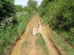
Progress in places proved to be hard due to the rutting, and in several places the entire width of the track was covered with water, causing me to have to hang onto the hedge to try and find my way though. It made for slow walking, particularly where the water lay in the ruts, and the mud proved to be fairly slippery, although thankfully was not too cloying in my boots. When the path rose out of dips the going was reasonable, but the dips were filled with water. It would not have been so bad if the track had not been so narrow, and any four wheel drives that did make their way down here must brush the hedges on either side. After a mile (which felt much longer due to the terrain underfoot) the track met a road, but I still had another mile further to go. The next section was equally as bad, and the mile went by slowly as I squelched my way through the mud. At one point I had little option but to go through he water, and this went into both of my boots, giving me wet feet for the rest of the day.
I was therefore quite thankful when I reached the point where I would turn off the track, and started heading westwards along a road. This turned out to be far busier than I would have expected for such a minor road, and when I switched on my Walkman I found out why - the A607 junction with the A1(T) was blocked, and this was obviously a diversion route. The traffic made the walk slightly more dangerous than I would have liked, and I often found myself stepping onto the verge to avoid streams of cars as they came past. Overhead gliders were being launched by tow planes, and these periods gave me good opportunities to watch the gliders as they separated from the planes, one curving away to the left and the other to the right.
Eventually the road ended at the A607, which was wider and I could walk long it more sensibly. The clouds overhead were becoming blacker, and a short shower followed. I had just passed the junction when a heard a loud squealing of brakes as a woman in a small car skidded to a stop at the junction behind me, causing me to jump with shock. The smell of burnt tire rubber wafted over me, and the driver looked apprehensive as she checked the junction and pulled out. It took me a couple of minutes for my heart to beat normally again, and by this time I was approaching Croxton Kerrial.
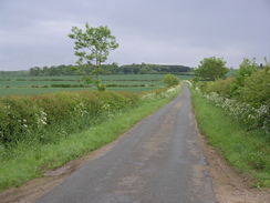
There was a pub a little further to the west, but due to the clouds overhead I decided to walk on, hoping that I could disappear into a pub when it was raining. The next couple of miles to Saltby were fairly boring with not much to see, as I followed the road along. At the church in the village I diverted off to the right to visit the pub, which I was glad to see was open. The miles of road walking had cleaned almost all of the mud off the soles of my boots, so I entered after checking if I was okay to do so with my boots on. They agreed, and this led to a pleasant break whilst I drunk a pint of beer and a pint of orange and lemonade, whilst I listened to the locals chat away.
After I left I followed a road south to Sproxton, and here I made a diversion from my planned route, which was to lead southeastwards to Buckminster. Instead I took a road that headed in a more southerly direction, leading down to the B676 road. On the map there is a footpath that would have allowed me to miss the B676, but there was no trace of this on the ground and so I carefully followed the road (which fortunately had wide verges) to reach Coston Lodge. Another road then led me on, and there was not much to see until the road approached Wymondham, where I unexpectedly came across a trig pillar on the left-hand side of the road. This find surprised me, and I took some photographs of it before heading on along the road.
Just before the road reached Wymondham there was a sailess windmill on the right, which is now a series of shops, including a tearooms. I went into the bustling car park beside the windmill to take some photographs of it, and ended up chatting to an elderly man in there, who was extolling the joys of walking, a fact hat I could hardly disagree with. A little further on the road passed over an old railway line, with a converted station building on the left, before reaching the centre of Wymondham. Some black cliuds were starting to gather in the distance and this acted as a spur for me to walk on, and I did not bother to stop to have a look at the church and instead bypassed it along the road.
This road took me down into the small village of Edmondthorpe and past the attractive village church. After this I took a footpath that entered a field with some curious cows in, who approached me as I crossed the field and were gathered around the gate as I exited it. On the other side I came across a man walking a dog, and after exchanging worrying comments about the dark clouds overhead walked on up a slight hill. On the way up it started to rain, heavy raindrops falling on the ground ahead of me. This forced me to put the hood of my coat for the first time of the day, although fortunately the rain was comoing from behind and not in front of me. It took me a surprisingly long time to reach a junction in the paths, where the footpath became a bridleway that headed towards the village of Market Overton, eventually climbing up a slight hill through crops, with some good views behind me as the rain finally cleared.
The path approached market Overton, passing the church before reaching the main road through the village. By this time I was feeling slightly fatigued, and although I had not got too wet in the rain, I was still ready for the end of the walk. The next couple of miles were a simple plod along the road, with the only item of any interest being he views oof RAF COttesmore off to the right, a short distance away across the fields. I studied this as I walked along, but as on Saturday (when I had walked around the eastern end of the airfield) there were no aircraft to be seen. I walked on, soon joining the toad in Thistleton and walked on to the church, where I recorded the end of the walk before walking on to my car, happy that a long walk had been completed.
Directions
The first section of this walk follows the Viking Way as it heads northwards along the Lincolnshire / Leicestershire border. From Thistleton church, head west along the road that leads out of the village. Ignore a junction to the left immediately outside the village, and instead follow the road as it curves to the right to take a more northwesterly course. It crosses the border out of Rutland and soon afterwards passes the abutments of an old railway bridge. Immediately after this a road comes in from the right; ignore this road, and instead continue along the road for another hundred yards until a road comes in from the left. Turn left and follow this road westwards for about half a kilometre until a left-hand bend is reached. On the apex of this bend a track leads off to the right.
Turn right and follow this track as it heads northwards, passing Crown point Farm. Shortly after this it curves to take a more northwesterly course for about a kilometre, before curving once more to head northwards, skirting past a mast before ending a kilometre later at a road in Sewstern. Turn right along this road, and follow it as it heads eastwards for about half a kilometre until it ends at a T-junction, and then turn left to follow another road northwards. This heads out of Sewstern, crossing the B676 road before continuing on for another kilometre before ending at a T-junction with another road beside a water tower. Cross the road and continue straight on along a wide track, with the water tower to the left. This heads in a slightly west of north direction for the next few miles, crossing a road before coming to the old Saltby airfield.
When the track reaches the perimeter road around the edge of the airfield, follow the obvious signs that direct you around the eastern edges, mainly following the perimeter road as it nears the club house and a large expanse of concrete used to assemble gliders. The path then passes the end of the wide runway, before curving to the left as it leaves the concrete perimeter road and becomes a rutted track. Before long this turns sharply to the right, to regain a more northerly direction. The track became narrower as it heads on, and was quite badly rutted when I walked it, making for slow progress. After about a mile the track meets a road; cross this road and continue on for another mile until it meets another road, where this route leaves the Viking Way.
At the road turn left and follow another road southwestwards for about a mile, as it curves to head westwards before ending at the A607 road. Join the A607 road and follow it westwards for about half a kilometre, until it enters the village of Croxton Kerrial. Take the first road off to the left, which initially heads south, before taking a more southeasterly course; after a couple of miles it reaches Saltby church. At the church turn right along a road that curves through the village, before ending at a T-junction beside the road. Turn left along this road, and follow it eastwards for a couple of hundred yards until it ends at another T-junction.
At this junction turn right, and start following a road southwards out of Saltby for about a mile and a half towards Sproxton. At the church the road curves sharply to the right; continue along the road as it does so, and head on into the centre of the village. Follow the road that passes a chapel on the left, before curving sharply to the left and then taking a more southeasterly course as it leaves the village. After a couple of hundred yards a road leads off to the right; join this road and follow it southwards for about a mile until it ends at the B676 road. Turn right to follow the B676 as it heads southwards, soon curving to the right to approach Coston Lodge. Just before the lodge is reached, turn left along another road, which soon curves sharply to the left and then right.
This road heads southwards for a little under two miles, passing a trig pillar on the left before reaching a road junction. Turn left to head south along this road for about a kilometre, as it descends down to end at a junction in the village of Wymondham. Turn left for a few yards, and then turn right down another road, which heads south out of the village for about a kilometre before approaching Edmondthorpe. When a junction is reached turn left and follow the road into the village; when it curves to the right once more continue straight on along another road that passes the church and a hall, both on the right. A little further on a footpath leads off to the right; take this footpath as it heads southeastwards across a field, before entering another one where it climbs up a small hill through a field of crops.
A little way beyond the top of the hill a junction with bridleways and footpaths is met near a hedge. Continue straight on, this time along a bridleway, which again heads southeastwards across a couple of fields, eventually climbing up a hill and turning to the right to go down a short lane, passing market Overton Church before ending at a road in the village. Turn left and start following this road as it heads northeastwards out of the village, and continue along it for a little over two kilometres as it passes to the north of Cottesmore Airfield. After passing some barns on the right, the road curves sharply to the left to end at a T-junction. Here turn right, and follow a road for a short distance as it enters Thistleton; this walk ends where it began, by the church in the village.
Distances
| From | To | Distance (m) | Ascent (ft) | Descent (ft) |
|---|---|---|---|---|
| Thistleton church | Sewstern | 3.9 | 135 | 72 |
| Sewstern | Croxton Kerrial | 7.2 | 305 | 272 |
| Croxton Kerrial | Sproxton | 3.6 | 128 | 206 |
| Sproxton | Wymondham | 4.0 | 105 | 183 |
| Wymondham | Thistleton church | 5.0 | 262 | 202 |
This makes a total distance of 23.7 miles, with 935 feet of ascent and 935 feet of descent.
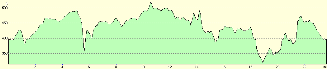
For more information on profiles, ascents and descents, see this page
Disclaimer
Please note that I take no responsibility for anything that may happen when following these directions. If you intend to follow this route, then please use the relevant maps and check the route out before you go out. As always when walking, use common sense and you should be fine.
If you find any information on any of these routes that is inaccurate, or you wish to add anything, then please email me.
All images on this site are © of the author. Any reproduction, retransmissions, or republication of all or part of any document found on this site is expressly prohibited, unless the author has explicitly granted its prior written consent to so reproduce, retransmit, or republish the material. All other rights reserved.
Although this site includes links providing convenient direct access to other Internet sites, I do not endorse, approve, certify or make warranties or representations as to the accuracy of the information on these sites.
And finally, enjoy your walking!
Nearby walks
| # | Title | Walk length (miles) |
|---|---|---|
| 58 | Stamford to Oakham | 16.8 |
| 59 | Oakham to Melton Mowbray | 10.6 |
| 66 | Melton Mowbray to Bingham | 16.1 |
|
|

|