Walk #635: Marks Tey to Manningtree via Colchester
 |
 |
|
General Data
| Date Walked | 11/12/2004 |
| County | Essex |
| Start Location | Marks Tey |
| End Location | Manningtree railway station |
| Start time | 08.26 |
| End time | 13.43 |
| Distance | 17.4 miles |
| Description | This was a long road slog, passing through Colchester on the way. Despite this I found it to be quite an interesting walk. |
| Pack | Today I carried my 30-litre Karrimor HotRock rucksack, which was filled with three litres of water, a spare fleece, waterproofs and various electronic gadgets. |
| Condition | I feel perfectly fine after this walk, and I could easily have walked further if I had needed to. It was not a very strenuous walk, and the fact that I was wearing trainers protected my feet to a large extent. |
| Weather | The day was overcast, with occasional glimpses of the sun through the cloud. I was not a cold day, although when I was exposed to the slight breeze I felt chilly. |
| OS map | Landranger number 168 (Colchester, Halstead & Maldon) |
 |
 |
|
 |
 |
|
Map of the walk
Maps courtesy of Google Maps. Route for indicative purposes only, and may have been plotted after the walk. Please let me have comments on what you think of this new format. For a detailed table of timings for this walk, please see the table file.
 |
Notes
I did not feel like doing too much of a strenuous walk today, and so I decided on doing this walk, which is one that I have been meaning to do for a few weeks now. The main aim of the walk was to connect a previous couple of walks eastwards from Bishop's Stortford to Marks Tey with my coastal walk in two places; to the southeast of Colchester on the River Colne, and on the River Stour at Manningtree. Unfortunately it was very hard to find an off-road route to complete this walk, and so I chose instead to make it a day of road walking, which rather limited the opportunities to do it as I rarely feel like doing a day's road walking out of choice.
There were a beautiful red sunrise as I drove to Marks Tey, and when I arrived at the long-stay car park next to the station I was relieved to find that it was free to park there at weekends. It did not take me long to get my pack on, although I soon realised that I had forgotten my woolly hat, and before I had even walked to the railway station to start the walk my head was quite cold.
The initial part of the walk took me over a footbridge over the busy A12(T), and I started following the B1408 eastwards towards Colchester. There was a pavement for the entire way as I passed through the villages of Copford, Stanway and Lexden, but there was really not much of interest. I was feeling quite low as I walked, and whenever I started to feel low I started jogging; the idea being that I could not feel too low whilst gasping for breath. This meant that I made good time, and I soon found myself entering Colchester.
Along the road ahead of me I saw a series of blue flashing lights and a couple of police cars came roaring past me. Before I reached them I turned off, heading through the centre of Colchester and passing a Saturday market that was bustling despite the fact that it was not even ten o'clock in the morning. Whilst the walk into the city had not been very attractive I found the centre to be a vibrant, interesting place, and I enjoyed my stroll though it.
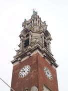
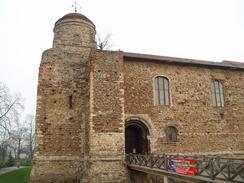
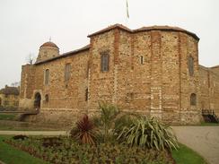
I soon reached the 1902-built town hall, a magnificent building designed by John Belcher that is topped with a marvellously intricate clock tower. A little further on down the road I came to the reason why I had chosen to make the diversion through the town - Colchester Castle. I found this to be an awe-inspiring structure, and so it should be - it was the largest Norman Keep ever built, and was designed by the same man who designed the White Tower at the Tower of London.
The slow walk around the castle took me five minutes, and I took many photographs of the building. It used to be much taller, but the top two storeys were removed in 1683; the castle only survives because the man who was demolishing it ran out of money! The temple is built on the site of the colossal Temple of Claudius, and uses the Roman temple vaults as its base; indeed, much of the walls are constructed from Roman rubble from the temple. I found it to be a fascinating site, and I only just managed to resist the temptation to go into the museum housed inside, which had only just opened for the day.
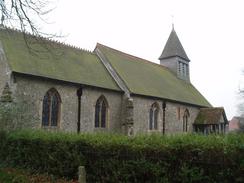
I left the castle, passing a beautiful war memorial bedecked with an elegant statue, and headed off along side streets to reach Colchester Town station. There was little of interest at the station, which is a terminus, and so I headed on eastwards away from it. However when I was in the car park of the station I managed to get a lovely view over Colchester, and I could clearly see the remains of ruins of St Botolph's Priory next to the present-day St Botolph's Church.
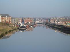
My next target was to reach the bridge over the River Colne at the Haven, and thus connect up with my coastal walk. Near the bridge the road paralleled the river and there were several boars moored; one of these was in a decrepit state and was half sunken. I found reaching the bridge to be quite a strange, melancholic moment - I had last been there on my coastal walk a little over two years before, and I found that I could remember the surroundings quite well, including the lightship that is moored a little way downstream from the bridge.
More road walking took me northwards out of Colchester, passing through a seemingly-endless housing estate before reaching the Beehive Pub at the bottom of Crockleford Hill. I was tempted to nip in for a quick drink as I was ahead of schedule, but unfortunately it was not open and so the opportunity was missing. The next few miles saw me heading northeastwards along minor road, crossing the A120 on a bridge before eventually reaching the B1029 at Burnt Heath. On the way I passed a tall structure in a field made entirely of hay bales - it had a green tarpaulin draped over it, and from a distance it looked exactly like a barn, a sight I found to be slightly incongruous.
More roads led me northeastwards to my next target, a trig pillar that proved easy to find in a field beside the road and adjacent to a public footpath. I took some photographs of it but it was nothing special, and I soon found myself heading on once again for the short walk into Manningtree. The town is situated at the end of the estuary of the River Stour, and I had visited the town on my coastal walk a couple of years before - the walk from the River Colne in Colchester had taken me over three days then via Clacton-on-Sea and several other innumerable estuaries, but going cross country only took me half a day!
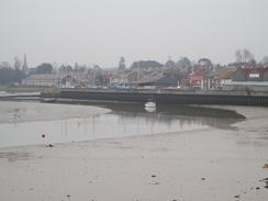
By the time that I reached the river I had plenty of time before the next train, and so instead of walking the direct route that I had planned to the station along the B1352, I decided to make a diversion by following the flood bank instead. It felt odd to be walking in the wrong direction - with the sea on my right instead of my left, but as the tide was out I enjoyed looking at the wide expanses of mudflats that had been uncovered.
After passing under a railway bridge I reached the A137, and I walked along this for the last half-mile to the railway station, where I arrived in plenty of time for the next train. The journey back was fine, although I got a little cold whilst waiting for my connection at Colchester Station. As I sat on the cold metal seat I reflected on a day that had hardly been a classic walk, but had been an enjoyable and fulfilling one nonetheless.
Directions
This walk starts off at Marks Tey railway station. Leave the station and turn right, to walk along the access road southwestwards for a few yards until a bus stop is reached. Here turn left and carefully cross a road to reach the bottom of a footbridge; climb this footbridge and cross over the A12(T) below. Once on the other side turn left and walk past a white garage to reach a roundabout. At this roundabout turn right and follow the B1048 road as it heads eastwards through Copford and Stanway. When a roundabout with the A1124 is reached continue straight on along the road, which is now the A1124.
The road heads eastwards through Lexden until a large roundabout is reached at the junction with the A134 road on the western outskirts of Colchester. Head straight on at the roundabout, and then take the first road to the right, the A137 High Street. This initially heads northwards before curving around to the right; follow it as it does so and head east along it, passing the town hall before reaching Colchester Castle. Leave the castle by the gates by the statue and head south along a road that soon meets up with Queen Street. Follow this downhill to a roundabout, and then turn left for a short distance to reach Colchester Town railway station.
From the railway station continue on eastwards along the A134 Magdelan Street, which becomes Barrack Street and Hythe Hill before eventually curving away to the right to meet the western bank of the River Colne. Follow it south for a couple of hundred yards until a roundabout is reached, and then turn left to cross the River Colne via the Hythe Bridge. Once on the other side follow the A134 as it curves to head more northwards, passing a roundabout and climbing a bridge over a railway line before reaching a large roundabout with the A133 road.
At this roundabout take the third exit, Avon Way, and follow this as it heads northeastwards around the edge of a large housing estate. The road eventually twists around to the left to head in a more northerly direction before ending at a T-junction with Bromley Road. Turn right and follow this road down a small hill, passing the Beehive Pub on the left, and then climb up the hill on the other side. The road continues on in a northeasterly direction, crossing the A120 on a bridge. When a fork in the road is reached turn left up Park Road; this heads northeastwards until the B1029 road is reached in Burnt Heath.
Cross the B1029 and once on the other side continue straight on along Waterhouse Lane; initially this heads slightly north of east, before curving to the left to head in a more northerly direction and ending at a T-junction with Little Bromley Road. At this junction turn right and follow it eastwards for a couple of hundred yards; when some power lines are reached turn left up Grange Road. This road twists and turns but maintains a rough northerly course before it ends at a T-junction with Bromley Road. Turn left and follow Bromley Road northwards for about a hundred yards until it in turn ends at a T-junction with the A137 road.
Turn right to head eastwards along the A137 for a few yards, and then turn half-right to head eastwards along the B1352 Long Road. Just after a slight bend to the left turn left down Colchester Road, and follow this as it curves to the right to pass a school, and then the left to head downhill to meet another branch of the B1352 road in Manningtree. Cross the B1352 and once on the other side enter the car park of a small supermarket. Once in the car park take a path on the right that leads up to the top of a flood bank. Once on the bank turn to the left and follow it as it heads northwestwards along the southern bank of the River Stour.
The footpath passes through a culvert under a railway line before reaching the A137 road immediately to the south of the bridge over the River Stour. Turn left to join the A137 as it heads southwestwards; after a few yards it curves to the left to take a more southerly course. Cross the railway line by either the level crossing or the underbridge and then turn right to walk up the access road to the railway station, where this walk ends.
Distances
| From | To | Distance (m) | Ascent (ft) | Descent (ft) |
|---|---|---|---|---|
| Marks Tey | Colchester Castle | 5.9 | 164 | 217 |
| Colchester Castle | Manningtree Station | 11.5 | 302 | 354 |
This makes a total distance of 17.4 miles, with 466 feet of ascent and 571 feet of descent.
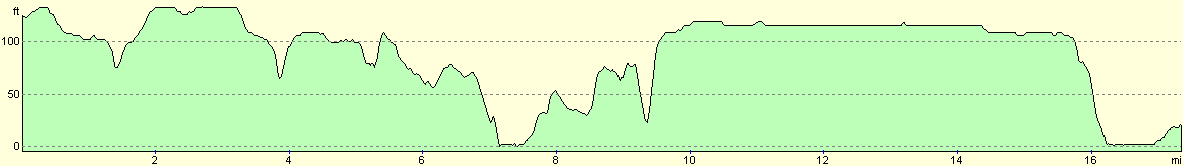
For more information on profiles, ascents and descents, see this page
Transport
There are hourly railway services between Manningtree and Marks Tey; you have to change trains at Colchester. A single ticket cost me £3.90, and the journey (including the change of train) took well under an hour.
Disclaimer
Please note that I take no responsibility for anything that may happen when following these directions. If you intend to follow this route, then please use the relevant maps and check the route out before you go out. As always when walking, use common sense and you should be fine.
If you find any information on any of these routes that is inaccurate, or you wish to add anything, then please email me.
All images on this site are © of the author. Any reproduction, retransmissions, or republication of all or part of any document found on this site is expressly prohibited, unless the author has explicitly granted its prior written consent to so reproduce, retransmit, or republish the material. All other rights reserved.
Although this site includes links providing convenient direct access to other Internet sites, I do not endorse, approve, certify or make warranties or representations as to the accuracy of the information on these sites.
And finally, enjoy your walking!
Nearby walks
| # | Title | Walk length (miles) |
|---|---|---|
| 265 | Nacton Church to Shotley Gate | 14.2 |
| 266 | Shotley Gate to Mistley | 14.2 |
| 267 | Mistley to Great Oakley | 18.0 |
|
|

|