Walk #267: Mistley to Great Oakley
 |
 |
|
General Data
| Date Walked | 15/11/2002 |
| County | Essex |
| Start Location | Mistley |
| End Location | Great Oakley Hall |
| Start time | 08.10 |
| End time | 15.16 |
| Distance | 18.0 miles |
| Description | This was a nice walk, a long walk along the southern bank of the River Stour was followed by a stroll southwestwards along sea banks past marshes to Great Oakley. |
| Pack | Today I carried my 30-litre Karrimor HotRock rucksack, which was filled with my packed lunch, waterproof leggings, water bottle and a couple of spare shirts, together with the usual assortment of odds and ends. |
| Condition | I feel absolutely fine after this walk, and have no significant problems to report. I could easily have walked further if the need had required. I think that I must be breaking some sort of record for not having blisters form, and I am generally feeling quite well. |
| Weather | The weather today was superb, with nice sunny skies and only occasional cloudy periods. The wind was much gentler than it had been yesterday and so it did not help to cool me down. It was a fairly mild day for the time of year, and all in all it was very good walking weather. |
| OS map | Landranger number 169 (Ipswich & The Naze, Clacton-on-sea) |
 |
 |
|
 |
 |
|
Map of the walk
Maps courtesy of Google Maps. Route for indicative purposes only, and may have been plotted after the walk. Please let me have comments on what you think of this new format. For a detailed table of timings for this walk, please see the table file.
 |
 |
|
Notes
This was one of the most enjoyable walks that I have done for a while. I cannot really say what made it so nice, but the weather probably has much to do with it. It was so nice walking in the sun without any fear of getting wet, and I walked on some sot of automatic pilot for most of the day, just walking and not thinking heavily as I frequently do on these walks.
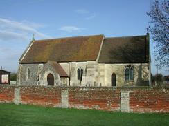
All Saints Church at Wrabness was quite nice, particularly for the fact that it has a separate wooden structure outside the church housing the bell. From a quick read of a history of the church, it seems that the church used to have a tower with bells in it, but it was full so when they wanted an extra bell they put it outside. In the nineteenth century the tower either fell down or was demolished, leaving he only bell as being the one in the wooden cage outside the church. I had heard of such bells before, but had never seen one. As the cage was not locked it gave me the opportunity to have a look inside the cage at the bell and see the mechanism more closely - it is extremely hard to get permission to view bells when they are in towers.
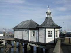
As I was walking up the road towards the pier in Harwich I met Sam, who was walking down in the opposite direction. We then walked up together towards the pier, and sat down and chatted whilst I ate the lunch that she had brought with her. The area around the ha'penny pier is very nice, and it was lovely sitting there in the sunshine, watching lorries go into the docks and looking at the boats moored in the river. It was a really lovely spot, and I found myself not wanting to walk on. I could easily have sat there all day, but after twenty minutes I got restless and so I walked on. The pier itself is named after the toll that was once charged for admittance, and it was built between 1851 and 1854. The buildings at the front of the pier are lovely white buildings with black roofs, and looked splendid in the sunlight.
Harwich has many interesting buildings, the most dominating of which must be the High Lighthouse near the centre of the town, which is a lovely example of this type of building. It was built as one of a pair, with the Low Lighthouse being 150 yards away, and much nearer to the sea. John Rennie built these lighthouses in 1818 and the silting up of the channels meant that two new ones had to be built by the beach at Dovecourt. The new ones are strange structures on stilts that I passed a short while later, and again these had a short working life due to the channel silting up. The Low Lighthouse is now the local maritime museum, and is a very peculiar looking building.
Another interesting buildings is the treadwheel crane, a 17th century manually operated crane which is by The Green. This is housed in a wooden building, and I was quite intrigued by how it must have been operated. Apparently it had no brake, which means that I would not want to be one of the two people driving it if the load went out of control! It was moved to The Green form it's original location in the Naval Yard in 1932, which explains why it is so far from the sea or a dock!
Harwich was a naval base during the two world wars, and as linked with both minesweeping and destroyers. Indeed, earlier on in the walk I passed a nature reserve to the west of Wrabness which had been a naval mine depot from 1921 to 1963 when the buildings were demolished. The naval base in Harwich finally closed in 1976, but it seems as though the town still looks back with pride at the way it helped out in both wars.
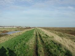
On the way south from the beach at Dovercourt I walked along the sea defences with a man who was out for a stroll and was watching birds for the same time. We walked for a couple of miles together before he turned back at the track that leads up to the main road between Little Oakley and Great Oakley. He told me that the sea bank to the south of this path was inaccessible due to the presence of an explosives factory on the marshes nearby, and indeed there was a sign stating 'You are approaching a restricted area. This is not a public right of way or footpath. You are strongly advised to return the way you came as trespassers caught anywhere in this area will be prosecuted under the Explosives Act of 1875 and 1923'. This is by far the most strongly worded sign I have seen so far on this trip, and that and the many strands of barbed wire removed any notions that I may have had of continuing on along the bank. If you look a the map the location of the works is almost ideal - being out on the marshes if there were to be a explosion damage would be limited, and all the buildings marked on the map are widely spaced so that any explosion in one building is unlikely to spread to any other.
I have now finally finished the walk around the Orwell and Stour estuaries and now have a slightly saner day or two along the coast with few inland diversions. Unfortunately after this they start again, initially with a walk into Colchester, and so one again I will have to get used to walking many miles inland before being able to walk back to the coast only a short distance from where I started.
Tomorrow is my first driver change of the walk. Sam is going away diving for a week in the Red Sea (a trip that was organised before we knew the start date of this walk), and so I have an old university friend Mike taking over for five days, followed by another friend for the last five before Sam gets back. Sam and I have developed such a good system for living in this van I find it slightly daunting that I am going to start to have to try and develop other systems to cope with other people. On the other hand, it will be very nice to share the experience of this trip with other people.
Directions
This walk starts off at the Thorn Hotel in Mistley. Leave the hotel and turn right to walk along the B1352 road. This soon rises up to cross over the railway line on a bridge before turning to the right and then the left to enter New Mistley. The road continues on in a roughly easterly direction but twists and turns as it does so; there is no pavement and the road is fairly busy so extreme care must be taken. When the road curves to run very near to the railway line near grid reference TM 140314 turn left down a bridleway that heads under the railway line and meets the river to the east of Nether Hall.
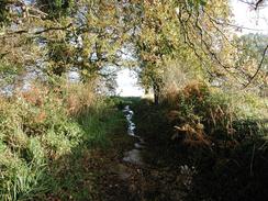
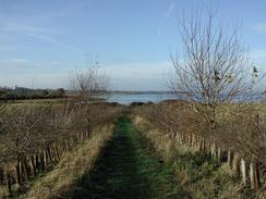
Turn right and follow the bridleway as it heads eastwards along the coast. The path runs at the top of the high-tide line and was extremely boggy in places when I walked along it; this made going slightly more tricky than would otherwise have been the case, but fortunately this difficult period was broken by a stretch of firm sand. After about a kilometre the Essex Way comes in from the right and this shall be followed until the B1352 road is met to the northwest of Ramsey. Continue along the Essex Way eastwards as it passes Jacques Bay before turning off to the right to enter a nature reserve, which is on an old naval site. Continue on through the reserve before heading back to head northeastwards on a bank with the river to the left and a small lake to the right. At the end of this bank descend down to a track and then continue straight on, to head eastwards along a path that climbs uphill between two lines of trees before passing to the left of a house at the top of the hill. At the house turn right down a track for a short distance to a road in Wrabness.
In Wrabness turn left to walk along the road past the church for a short distance before turning left to head down a footpath that leads back to the river with a caravan park to the left. At the river turn right and head southeastwards for a mile alongside the river to Strandlands. Here the river and path take a more easterly course, and passes through an area of woodland before turning to the right and climbing uphill to a bridge over the railway line. Cross the bridge and continue on along a track on the other side until it ends at the B1352 road once more.
Turn left and walk along the B1532 road. Ignore the Essex Way as it heads off to the right but continue on past Home Farm on the right until the road curves sharply to the right. At this bend continue straight on along a track that curves around to head eastwards past the farm at East Newhall. The first part of this track is not a right of way, but beyond the farm it is. Continue along this track as it slowly climbs uphill, passing a water treatment plant before passing to the right of many large white tanks belonging to an oil refinery at Parkeston. The track continues on and becomes surfaced as it approaches and finally ends at the A146 road near the entrance to the Harwich International Port.
At the end of the track turn right to head south down the A146 road for a little under a kilometre until a roundabout with the A120(T) is reached. At this roundabout turn left and walk for a short distance along the A120(T) to another roundabout with a tourist information office and a supermarket to the left. From this roundabout the road starts to climb up to cross the railway line by the Phoenix Bridge. The stretch of road up to and over the bridge has no pavement, but the verge was wide enough for me to walk over it with no worries. On the other side it descends to a roundabout, which is crossed over before another one is reached a kilometre later. At this roundabout turn left to head north through Bath Side, passing a Trinity House depot on the left before reaching the Ha'penny pier at the northernmost point of Harwich.
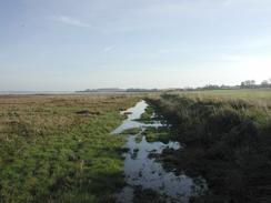
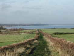
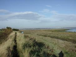
From the pier follow the road around as it heads through the town. The road curves to the left and then immediately to the right before running close to the sea near a lifeboat museum. At this point leave the road and join the promenade that runs southwards beside the sea. This path passes the treadmill crane and the Low Lighthouse before curving around and heading towards the breakwater. The section of promenade around the breakwater is uneven and sloping, but this annoying section soon ends at a nice flat promenade that heads southeastwards past Dovercourt. Walk down the seawall for a couple of kilometres until it turns to the right and ends at a car park. At the car park turn left and walk southwestwards along the sea bank, which was firm and good going despite the recent rain. Keep on the sea bank as it curves around to the south and then the southeast before it starts to head inland with a large area of marshes to the left. Eventually the path passes an area where cars can park before it ends at an area that is well secured with barbed wire.
At this point turn right and descend from the sea bank. Head along a bridleway that passes some trees before heading uphill to meet the B1414 road just to the southwest of Little Oakley. At the road turn left and follow it as it heads southwestwards towards the village of Great Oakley. Take great care on this section as the road is twisting and there is no pavement. This walk ended in a little area next the driveway leading to Great Oakley Hall, which is about a kilometre to the east of the village and was the only place that Sam could find to stop.
Distances
| From | To | Distance (m) | Ascent (ft) | Descent (ft) |
|---|---|---|---|---|
| Mistley | Harwich | 10.8 | 449 | 476 |
| Harwich | Great Oakley Hall | 7.2 | 220 | 144 |
This makes a total distance of 18.0 miles, with 669 feet of ascent and 620 feet of descent.

For more information on profiles, ascents and descents, see this page
Accommodation
We stayed at Grange Farm, OS Field 221 a/b, Thorp-le-Soken, Clacton, Essex CO16 0HG. They can be contacted on 01255 861208. This site cost us ten pounds for two nights, and the shower tokens cost fifty pence per token, and a token lasts about six minutes. This was a nice little farm site, and has six horses and a psycho dog.
Disclaimer
Please note that I take no responsibility for anything that may happen when following these directions. If you intend to follow this route, then please use the relevant maps and check the route out before you go out. As always when walking, use common sense and you should be fine.
If you find any information on any of these routes that is inaccurate, or you wish to add anything, then please email me.
All images on this site are © of the author. Any reproduction, retransmissions, or republication of all or part of any document found on this site is expressly prohibited, unless the author has explicitly granted its prior written consent to so reproduce, retransmit, or republish the material. All other rights reserved.
Although this site includes links providing convenient direct access to other Internet sites, I do not endorse, approve, certify or make warranties or representations as to the accuracy of the information on these sites.
And finally, enjoy your walking!
This walk was mentioned in the following routes:
| My walk around the coastline of Britain |
Nearby walks
| # | Title | Walk length (miles) |
|---|---|---|
| 263 | Bawdsey to Waldringfield | 17.9 |
| 264 | Waldringfield to Nacton via Felixstowe | 19.6 |
| 265 | Nacton Church to Shotley Gate | 14.2 |
|
|

|