Walk #266: Shotley Gate to Mistley
 |
 |
|
General Data
| Date Walked | 14/11/2002 |
| County | Suffolk, Essex |
| Start Location | Shotley Gate |
| End Location | Mistley |
| Start time | 08.10 |
| End time | 13.59 |
| Distance | 14.2 miles |
| Description | This was a lovely walk following the northern bank of the River Stour eastwards. |
| Pack | Today I carried my 30-litre Karrimor HotRock rucksack, which was filled with my packed lunch, waterproof leggings, water bottle and a couple of spare shirts, together with the usual assortment of odds and ends. |
| Condition | I feel absolutely fine after this walk, and could very easily have walked further. The biggest problem that I had today was my hangover, which took some time to clear. |
| Weather | I woke up this morning to the van rocking in the high winds, and with heavy rain lashing the van at the same time. Fortunately by the time I came to start the walk the rain had stopped, although the gusting winds were with me for a long time. The day was mostly sunny, with the high winds bringing in a couple of prolonged showers to annoy me. The day was quite mild, and I got quite warm when sheltered from the wind. |
| OS map | Landranger number 169 (Ipswich & The Naze, Clacton-on-sea) |
 |
 |
|
 |
 |
|
Map of the walk
Maps courtesy of Google Maps. Route for indicative purposes only, and may have been plotted after the walk. Please let me have comments on what you think of this new format. For a detailed table of timings for this walk, please see the table file.
 |
 |
|
Notes
Another day, another county. Near the end of today's walk I crossed the bridge over the Stour, and hence entered Essex, which will take up all of my attention for the next three weeks. I find it quite sad to be leaving Suffolk, as it has been a county that I have enjoyed walking through and knew well already; although I have done a few walks in Essex before I am much less familiar with the area.
It is Sam's birthday today, so I wanted to do a relatively short walk so that I could spend more than the usual time with her this afternoon. As a treat we also decided to spend the night in a hotel - the first time on this trip that we have slept anywhere other than the van, so I am expecting it to make a nice change.
For the majority of this walk I was following the Suffolk Heaths and Coasts Path, as I have for much of the time from Lowestoft and when I got to Lower Holbrook I was amused to find a sign stating that the path that I had followed was now closed due to a landslip and that the path now passes far inland. I had seen no sign of any significant landslip, and although the path was narrow in places it was all easily passable.
I started the walk today with a headache that was due to the alcohol I had drunk last night. This made the first part of the walk less than enjoyable, and it was some time before I started feeling any better. The high winds did not help the situation, so I was relieved when they started to die down.
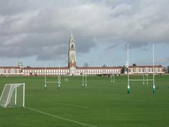
At Holbrook I passed near to the Royal Hospital School, which is dominated by the 200-foot high clock tower, which is topped with a white stone pinnacle. The school moved here from Greenwich in 1933 after Mr Gifford Sherman Reade donated the land in appreciation of the Navy's work in the First World War. The school was originally founded for the sons of seafarers in 1694, so it has a long history even before it moved to this site.
I took my time walking through Mistley, topping to go into a newsagents and to look around the town. The town is famous for the two Mistley Towers, which are two towers that were part of a church by Robert Adam. The central part of the church was demolished when the new church was built, leaving behind the two graceful and beautiful towers. The town had a smell of hops in the air, and so it was no surprise when I found out that the town has malthouses in it.
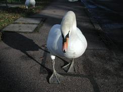
Whilst walking along the sea front towards the hotel I saw a group of large swans sitting on the pavement. As I approached they did not move as I expected them to but stayed impassive as I got nearer. One even came right up to me and started trying to nose (or perhaps beak is a better time) into the plastic bag I had in my hand. As I walked on down the street one of the swans followed me, and a man sitting in a car told me that when he had first parked the swan had gone up to the car and tapped it's beak on the window!
In Manningtree I saw my first milestone for London - stating that London is sixty miles away. It will take me far more than that and three weeks to get there. It also marked Colchester as being nine miles away, and again it is going to be much further than that the way that I am going.
The hotel that we are staying in, the Thorn Hotel, is rumoured to have an interesting and slightly disturbing history. In the seventeenth century the hotel was allegedly owned by Matthew Hopkins, who is better known as the Witchfinder General, and his (and other) ghosts reputedly haunt the hotel. It looks as though we may get a relatively good nights sleep however, as we are not staying in the haunted room.
Directions
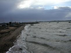
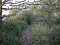
This walk starts off at the riverfront in Shotley Gate. Continue along the riverfront until the road ends, and then continue on westwards on a narrow path beside the river defences. Some steps then lead up to the right through an area of woodland before turning to the left and heading through the woodland. The woodland ends at the end of the village and the path emerges onto the top of a small cliff above Erwarton Bay. Continue on along the path towards and past two houses before descending down towards a marshy area.
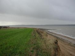
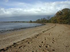
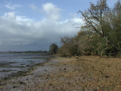
The path continues on through fields beside the marshland southwestwards to Erwarton Ness. Here the marshland ends and the path turns to head in a more westerly direction Fairly soon it descends down past a riverbank near Beaumont Hall before ascending again on top of some small cliffs. When the path passes Nether Hall I went down onto the foreshore, where there is a slightly sandy beach, which I followed around to the inlet at Lower Holbrook. If the tide is high you could either continue along the path or take a more inland route.
Walk around the inlet at Lower Holbrook, with boats floating in the water or sitting in the mud depending on the tide in the creek. Follow the path around the top of the riverbank and then turn right, crossing a stream and heading along past some paddocks before ending at a path beside some playing fields for the school. Turn left up this path and follow it uphill past some houses, where it becomes a track and then a road that passes Stutton Church. Continue on westwards along the road into Stutton, and when the road turns to the right continue straight on down a short track. When the track ends continue on along a footpath through a field until a track is reached. Turn left and descend down the hill, passing Crepping Hall before eventually meeting the river once more at Stutton Ness.
At Stutton Ness turn right and follow the path westwards along the top of a small cliff, with a narrow band of sandy foreshore below. The path winds around the cliff top, passing through a couple of wooded areas before reaching the Newmill Creek beside Stutton Mill. The path turns right and passes the mill before turning left along a riverbank past the end of the creek. The path continues on along the top of the riverbank past Seafield Bay until it starts to curve around to the left. At this point take a path that leads off to the right and heads westwards, climbing uphill before turning to the right and joining a track to a bridge over a railway line.
Cross the bridge and immediately on the other side turn left to head down a track. This track passes to the left of a small water treatment plant as it plunges downhill before meeting the fence of a factory. At the fence turn right and head along a path which enters a small area of trees with a nice lake to the right. The path soon meets the end of a track and continues along this track past a series of factories, the first of which is an ICI Imagedata plant. The track soon becomes surfaced as it continues on and ends at the A137 road. Just before the A137 road is reached turn left and cross an area of water over an old brick bridge. On the other side of the bridge climb up and join a pavement that runs beside the main road towards the bridge over the River Stour.
Cross the bridge over the river and enter Essex. On the other side of the bridge turn left and follow a footpath which runs along the top of the riverbank. This path passes under the railway line on a low bridge. On the other side of the bridge continue along the riverbank until it meets a supermarket car park in Manningtree. Walk through the car park and join the B1352 road. Turn left and walk through the attractive little town along the road. The road continues on, passing the two Mistley Towers before reaching the Thorn Hotel on the left, where this walk ended.
Distances
| From | To | Distance (m) | Ascent (ft) | Descent (ft) |
|---|---|---|---|---|
| Shotley Gate | Lower Holbrook | 5.5 | 223 | 233 |
| Lower Holbrook | Mistley | 8.7 | 371 | 354 |
This makes a total distance of 14.2 miles, with 594 feet of ascent and 587 feet of descent.
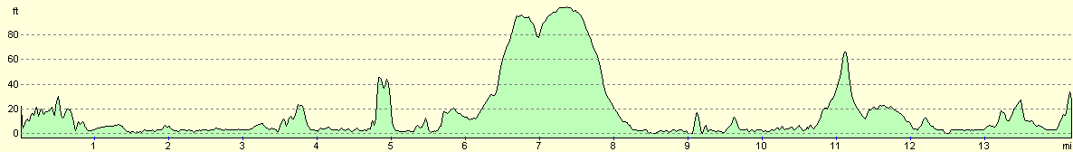
For more information on profiles, ascents and descents, see this page
Accommodation
We stayed at the Thorn Hotel in Mistley, which cost us sixty pounds for a double room for the night. This was a reasonable hotel, with a dark history that helped to make the stay fascinating. The contact details of the hotel are: The Thorn Hotel, High Street, Mistley, Manningtree, Essex CO11 1HE. They can be contacted on 01206 392133.
Disclaimer
Please note that I take no responsibility for anything that may happen when following these directions. If you intend to follow this route, then please use the relevant maps and check the route out before you go out. As always when walking, use common sense and you should be fine.
If you find any information on any of these routes that is inaccurate, or you wish to add anything, then please email me.
All images on this site are © of the author. Any reproduction, retransmissions, or republication of all or part of any document found on this site is expressly prohibited, unless the author has explicitly granted its prior written consent to so reproduce, retransmit, or republish the material. All other rights reserved.
Although this site includes links providing convenient direct access to other Internet sites, I do not endorse, approve, certify or make warranties or representations as to the accuracy of the information on these sites.
And finally, enjoy your walking!
This walk was mentioned in the following routes:
| My walk around the coastline of Britain |
Nearby walks
| # | Title | Walk length (miles) |
|---|---|---|
| 107 | Stowmarket to Ipswich | 16.1 |
| 131 | Ipswich to Wickham Market Station | 16.7 |
| 263 | Bawdsey to Waldringfield | 17.9 |
|
|

|