Walk #669: Laggan to Kingussie
 |
 |
|
General Data
| Date Walked | 11/05/2005 |
| County | Highlands |
| Start Location | Monadhliath Hotel |
| End Location | Kingussie |
| Start time | 10.20 |
| End time | 17.23 |
| Distance | 13.9 miles |
| Description | This was an enjoyable walk along roads and across a superb example of moorland. |
| Pack | Today I carried my 70-litre Craghoppers WildPlaces rucksack, filled with full camping gear. |
| Condition | I feel absolutely fine after this walk, which is to be expected as it was a relatively unstrenuous stroll with no great ascents or descents to tire me out. |
| Weather | The weather today was mainly sunny, with only a few clouds to spoil the day. It got quite warm in the afternoon, but the wind help me keep cool. |
| OS map | Landranger number 35 (Kingussie & Monadhliath Mountains) |
 |
 |
|
 |
 |
|
Map of the walk
Maps courtesy of Google Maps. Route for indicative purposes only, and may have been plotted after the walk. Please let me have comments on what you think of this new format. For a detailed table of timings for this walk, please see the table file.
 |
 |
|
Notes
I had a slightly unsettled night's sleep last night, and when I woke up I lay in bed; instead of doing my notes of yesterday's walk I started to read the novel that I got given seemingly ages ago in Alltbeithe youth hostel. I had resolved to walk with Nik today, and so I got up for a late breakfast, and after taking my time getting ready we eventually headed off at well after ten; far later than I would normally head off in the morning.
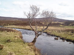
We stopped nearly instantly so that Nik could get a sandwich and some cake from an adjacent shop. I am really not used to stopping after only a few minutes walking and this proved to be a slight shock to the system, but we were soon on the way again, walking eastwards along the A889 which fortunately was not too busy. By the phone box at Catlodge Nik phoned in our positions to challenge control, and we left the main road for another, quieter road that headed eastwards above the southern bank of the River Spey. We kept on stopping to look at views and drink water, but we had an amiable chat as we strolled along. By a memorial near Mains of Glentruim we met another challenger, Ian Wood (304(, and we all walked on together towards the A9.
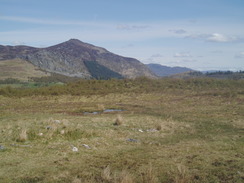
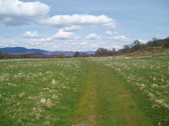
We had to follow the cycle path that runs alongside the A9 for about half a mile northwards, after which we said goodbye to Ian and we turned right along a track that led, initially the A9, and then on across some moorland. The A9 had been one of the milestones that I had set myself before I set off on the walk, and I was quite glad to have reached it. About halfway along the track across the moorland towards Phones we stopped and sat down to eat lunch and examine the superb view northeastwards down the glen. After the stop we continued on towards the houses at Phones, and then turned left to start following General Wade's Military Road.
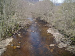
This stretch of walk was probably the best of the walk so far; after passing through an attractive area of woodland the path enters a fantastic area of moorland that reminded me of the eastern edges of the Peak District. We chatted as we strolled, and after taking another break near Drochaird Balbh Bordain, where there is an attractive little bridge over a stream. It really was a fantastic walk, and I felt sad as the path passed near to what we believed to be a bothy at Lubleathann and the path got less remote. At another stop I used the opportunity to book myself into the same place as Nik in Kingussie, having decided not to walk on to Kincraig due to the lateness of the hour. Fortunately I got a bed for the night, and this knowledge allowed me to relax slightly as we headed on, the noise of the rapidly approaching A9 intruding into our conversation.
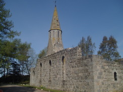
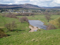
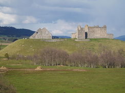
We took the wrong path down to the A9, but instead of walking along that we took a side road that ran parallel before diving under the main road and heading towards Ruthven. We stopped to chat to the owners of a B&B at the corner of the B970 and I also took some long-distance views of the spectacular Ruthven Barracks, before we headed down the road towards the centre of Kingussie, which seemed like an amiable little town as I walked through it. Eventually we reached the bunkhouse which is situated right behind a bar, and we stopped off for a drink and to get our keys. Walking with someone (and particularly someone who stops frequently) was an unusual but pleasurable experience and I must say that even if we had set off an hour earlier and stopped less I would definitely not have enjoyed the walk as much.
Directions
This walk starts off at the Monadhliath Hotel in Laggan. Leave the hotel and turn left, to follow the A889 as it heads eastwards for a couple of kilometres until a road junction is reached by a phone box at Catlodge. Here leave the A889, and follow a minor road as it heads eastwards along the southern bank of the River Spey. The road continues on for a little under four miles, eventually passing a campsite and crossing the River Truim before climbing up to end at the A9. Turn left and start following the cycle path that runs alongside the A9 northwards for about half a mile until a track leads off to the right; turn right and follow this track as it climbs up to reach the A9.
Cross the A9 and once on the other side join another track that is signposted for Phones Lodge. Initially this heads south before curing to head southeastwards as it crosses moorland before eventually dropping down into Phones. Pass a building and then turn left to join a track that heads northeastwards, soon entering some trees to the south of a little lochan before leaving the trees and entering a fantastic stretch of moorland. Continue along this track (part of Wade's military road network) as it heads northeastwards, passing Loch an Dabhaich before reaching Lochn Odhair near Luibleathann. Just before the latter lochan turn right along a minor track which skirts the lochan before continuing on. A deep ford is soon reached; there is a footbridge nearby that allows a dry crossing. The track then skirts an area of trees near Milehouse of Nuide and heads down to meet the A9 near Inverton. Turn right and follow the A9 eastwards for a few hundred yards before crossing it and taking a track that leads off to the right. This eventually drops down to cross under the A9 via an under bridge. Once on the other side continue along the track as it angles away from the A9 before eventually it reaches a road junction with the B970 in Ruthven. Turn left and follow the B970 as it heads northwards, passing under the A9 and crossing the River Spey before entering the village of Kingussie. When the B970 ends at a T-junction with the A86 turn right and walk northeastwards along the road for a few hundred yards until the Laird's bothy is reached on the right, where this walk ends.
Distances
| From | To | Distance (m) | Ascent (ft) | Descent (ft) |
|---|---|---|---|---|
| Monadhliath Hotel, Laggan Bridge | A9 | 5.7 | 686 | 633 |
| A9 | Kingussie | 8.2 | 525 | 676 |
This makes a total distance of 13.9 miles, with 1211 feet of ascent and 1309 feet of descent.
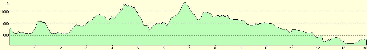
For more information on profiles, ascents and descents, see this page
Accommodation
I spent the night at the Laird's Bothy hostel in Kingussie, which cost me ten pounds for the night. The address is The Lairds Bothy, High Street, Kingussie, Inverness-shire, Telephone (01540) 661334.
Disclaimer
Please note that I take no responsibility for anything that may happen when following these directions. If you intend to follow this route, then please use the relevant maps and check the route out before you go out. As always when walking, use common sense and you should be fine.
If you find any information on any of these routes that is inaccurate, or you wish to add anything, then please email me.
All images on this site are © of the author. Any reproduction, retransmissions, or republication of all or part of any document found on this site is expressly prohibited, unless the author has explicitly granted its prior written consent to so reproduce, retransmit, or republish the material. All other rights reserved.
Although this site includes links providing convenient direct access to other Internet sites, I do not endorse, approve, certify or make warranties or representations as to the accuracy of the information on these sites.
And finally, enjoy your walking!
This walk was mentioned in the following routes:
| The Great Outdoors Challenge 2005 |
Nearby walks
| # | Title | Walk length (miles) |
|---|---|---|
| 668 | Fort Augustus to Laggan | 24.1 |
|
|

|