Walk #468: Ardlamont Point to Lephinmore
 |
 |
|
General Data
| Date Walked | 10/06/2003 |
| County | Strathclyde |
| Start Location | Ardlamont Point |
| End Location | Lephinmore |
| Start time | 09.18 |
| End time | 17.01 |
| Distance | 21.0 miles |
| Description | This was a long and fairly boring road walk, with not much to enliven it. |
| Pack | Today I carried my 30-litre Karrimor HotRock rucksack, which was filled with my packed lunch, waterproof leggings, water bottle and a couple of spare shirts, together with the usual assortment of odds and ends. |
| Condition | I did not have any trouble with my left foot today, which was a welcome relief, and indeed for the first fourteen miles I had absolutely no problems. After lunch, however, I started to feel ill, with a headache, nausea and sore throat, and these symptoms continued to get worse until the end of the walk. |
| Weather | It rained heavily all night, but fortunately by the time that I started the walk this had passed. Aside from a couple of light drizzle showers it remained dry until about ten minutes before I stopped for lunch, when it started to rain heavily. By the time I had finished lunch this stopped, although the afternoon had some fairly prolonged showers. It was quite windy first thing this morning, although fortunately this died out fairly soon. |
| OS map | Landranger number 62 (North Kintyre & Tarbert) and Landranger number 55 (Lochgilphead & Loch Awe) |
 |
 |
|
 |
 |
|
Map of the walk
Maps courtesy of Google Maps. Route for indicative purposes only, and may have been plotted after the walk. Please let me have comments on what you think of this new format. For a detailed table of timings for this walk, please see the table file.
 |
Notes
This walk was a little bit disappointing. I had been very tempted to try and follow the coast around to Portavadie and then northwards to meet the B8000 road near Otter Ferry, but with the heavy overnight rain I really did not fancy forcing my way around the coast, so I decided to stick to the road instead. This is precisely what I had intended to do when I was planning the walk, but since then I have been trying to stick to the coast more religiously than my rule of 'nearest right of way to the sea'.
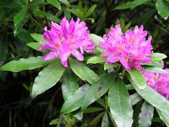
As was to be expected from such a long road walk, it was a bit trying and boring. There were some lovely views to be had at certain times, particularly the high section of road between Millhouse and Loch Melldalloch, but at others they were nothing special. As I walked along hate seemingly endless road my mind wandered, and I had a particularly weird and fanciful daydream that seemed to make he miles fly by. The traffic on the road was so light that I could afford to take my attention of what my feet were doing and just walk and daydream, and only the start of a heavy shower stopped me dreaming. I have not daydreamed whilst walking for a long time - I can only do it on terrain that is flat and level or I stand the risk of tripping and going base over apex, and if the road is busy then it is far too dangerous. If the conditions are right, however, it is a lovely way of whiling away the hours, and is surprisingly relaxing.
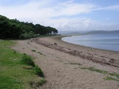
I met Sam at the pub at Oyster Ferry, and I was slightly surprised to find that mum and dad were there as well. I went into the pub and we had a chat whilst I supped a pint, and when my parents left Sam and I went into Mervan so that I could eat my lunch. By this time the rain had stopped and the sky was sunny, allowing some wonderful views over Loch Fyne towards the Kintyre peninsular, where I shall be in a couple of days. Otter Ferry was unsurprisingly the site of an old ferry service across the loch to West Otter on Kintyre, now sadly long-gone. In 2791 the fare was 3d for a man and 9d for a horse, which must have been very expensive for the times. When you consider that the alternative would have been a long walk or ride around the top of Loch Fyne, it must have been very tempting to use the ferry.
Within a few minutes of setting out again on the walk I started to feel ill. My legs were leaden (which was strange as they had been perfectly fine before lunch) and I started to get a thumping headache. I plodded on along the road feeling increasingly worse, and the symptoms were soon joined by a sore throat and nausea. Every half hour I was forced to stop for a couple of minutes just to relax myself, and the miles became increasingly hard to cover. I had arranged to meet Sam at Lephinmore, but about an hour after setting off I realised that I did not want to walk that far. I tried phoning her up to ask her to pick me up early, but unfortunately I did not have any mobile reception, so I was forced to continue on for a little over three miles to the end of the walk.
We had arranged to spend the night with my parents back at the campsite we stayed at two nights ago, so we had to drive for a little under half an hour to get there, Unfortunately I did not really feel like being terribly sociable. We had some lovely burgers, but my energy levels were at rock bottom and I just wanted to retire to bed, which was a big shame. I can only hope that a good night's sleep helps me recover, as I will need to be fit for tomorrow's walk.
Tomorrow I will hopefully reach Cairndow, at the northeastern end of Loch Fyne. We are all booked in to have a meal at the Oyster Restaurant there tomorrow night, so it makes a good nineteen-mile day to get there in time for that. If I feel like I do this evening, however, I shall not be walking tomorrow at all - my throat is sore and my head is far from clear. This is a shame, as I am really keen to get on with the walk around the Kintyre peninsular - it is a part of the walk that I have been looking forward to from the very beginning.
Directions
This walk starts off by the phone box on the road near Camp Cottage, about a mile to the north of Ardlamont Point. The directions for the walk are extremely simple. Simply head westwards along the road and follow it as it twists around past Ardlamont House, and then onwards as it turns to head northwestwards towards Craig Lodge. Here it turns to head northwards for a couple of miles until it reaches a junction with the B8000 at Millhouse.
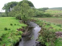
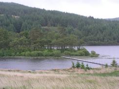
Head straight on northwards down the B8000 as it climbs onto some high ground. By Loch Melldalloch it steeply descends before heading through Drum and Kilfinan, where it climbs once again before descending down to Otter Ferry. From here the road continues along the coastline of Loch Fyne for more than six miles until Lephonmore Farm is reached on the left, where this walk ends.
Distances
| From | To | Distance (m) | Ascent (ft) | Descent (ft) |
|---|---|---|---|---|
| Ardlamont Point | Otter Ferry | 14.5 | 1706 | 1759 |
| Otter Ferry | Lephinmore | 6.5 | 502 | 456 |
This makes a total distance of 21.0 miles, with 2208 feet of ascent and 2215 feet of descent.
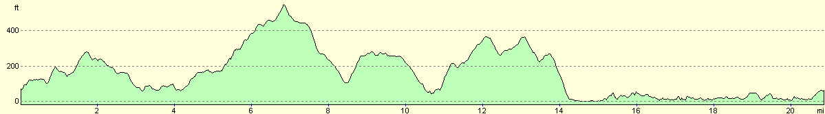
For more information on profiles, ascents and descents, see this page
Accommodation
We spent the night at the Glendraurel Caravan Park, Glendaurell, Argyll PA22 3AB. This site was quite nice and well situated for the end of the walk, and they can be contacted on (01369) 820267, and they have a website at www.glendaurelcaravanpark.co.uk. They very kindly knocked a few pounds off the price of the site as we are doing a charity event, and so it cost us five pounds for the night.
Disclaimer
Please note that I take no responsibility for anything that may happen when following these directions. If you intend to follow this route, then please use the relevant maps and check the route out before you go out. As always when walking, use common sense and you should be fine.
If you find any information on any of these routes that is inaccurate, or you wish to add anything, then please email me.
All images on this site are © of the author. Any reproduction, retransmissions, or republication of all or part of any document found on this site is expressly prohibited, unless the author has explicitly granted its prior written consent to so reproduce, retransmit, or republish the material. All other rights reserved.
Although this site includes links providing convenient direct access to other Internet sites, I do not endorse, approve, certify or make warranties or representations as to the accuracy of the information on these sites.
And finally, enjoy your walking!
This walk was mentioned in the following routes:
| My walk around the coastline of Britain |
Nearby walks
| # | Title | Walk length (miles) |
|---|---|---|
| 466 | Ardtaraig to Auchenbreck Burn | 19.6 |
| 467 | Auchenbreck Burn to Ardlamont Point | 17.1 |
| 469 | Lephinmore to Clachan | 20.2 |
|
|

|