Walk #469: Lephinmore to Clachan
 |
 |
|
General Data
| Date Walked | 11/06/2003 |
| County | Strathclyde |
| Start Location | Lephinmore |
| End Location | Clachan |
| Start time | 10.18 |
| End time | 17.46 |
| Distance | 20.2 miles |
| Description | This was a long road plod that was made bearable by the nice views available up and down Loch Fyne. |
| Pack | Today I carried my 30-litre Karrimor HotRock rucksack, which was filled with my packed lunch, waterproof leggings, water bottle and a couple of spare shirts, together with the usual assortment of odds and ends. |
| Condition | The biggest problem that I had today was with the underside of my left foot, which was aching towards the end of the walk and is sore to the touch. Aside from this I had no other problems, which is a good sign. |
| Weather | The weather today was very mixed, with some prolonged sunny periods, but also some light rain showers. There was not a great deal of wind, but the sun soon dried me out after the showers. |
| OS map | Landranger number 55 (Lochgilphead & Loch Awe) and Landranger number 56 (Loch Lomond & Inveraray) |
 |
 |
|
 |
 |
|
Map of the walk
Maps courtesy of Google Maps. Route for indicative purposes only, and may have been plotted after the walk. Please let me have comments on what you think of this new format. For a detailed table of timings for this walk, please see the table file.
 |
 |
|
Notes
I woke up this morning feeling much better than I did when I went to bed last night. My throat was no longer sore, and my headache had cleared up. I had also slept quite well, and this in itself made me feel much better. The first task of the day was to produce a CD that can be sent to Terry so that he could update my website, and fortunately this did not take too long as I had already done much of the preparatory work. By the time that I was packing my bag ready to set off I was starting to feel grotty again, so I took some cold and flu treatment that saw off the problem all day.
My parents drove me from the campsite to the start of the walk at Lephinmore. To get there we drove over the high pass that heads between Bealachandrain and Otter Ferry, from where there were some superb views in all directions. The pass goes up to 318 metres quite quickly, and early on there are some steep sections and sharp bends, so I am glad that we did not try to get Mervan along that road. The views along the road are supposed to be superb, but unfortunately forestry plantations blocked out many of them.
The first few miles were along the B8000 road that headed northeastwards past the runs of Lachlan Castle and the tiny village of Garbhallt. This stretch of road was quite a boring walk, but it was quiet and I could make good progress along it until I finally reached the junction with the A886. This road was also quiet, and as it was wider I found that it was better to walk along. On the way I passed two tractors that were cutting the grass verges, and these were the same people who I had seen cutting the verges of the A885 by Holy Loch a week or so ago.
The A886 soon joined the A815 on the outskirts of Clachan Strachur, which was a much busier road, although still not very busy when compared with English roads. I had arranged to meet Sam at the Creggans Inn in Creggan, about half a mile north of the road junction. We went into the MacPhunn's bar at the Inn, which is named after a local person, MacPhunn of Dripp, who was hung in Inverary for stealing sheep. His wife rowed the body back across the loch, and on the way she thought she saw some movement, and mixing some whisky with her own milk (she was nursing a baby at the time) she forced the liquid between his lips. He was quickly restored to life, and they landed a few hundred yards up the loch from the pub. I was still feeling slightly grotty, so instead of having a pint (or a mixture of whisky and milk) I had an orange and lemonade, which was quite refreshing.
Sam had been planning to drive into Lochgilphead so that she go to the library and check our emails, but whilst we were in the pub we found out that the local post office had Internet access. We quickly drunk up, but when we got to the post office the computer was in use, so am dropped me of back at the pub so I could restart the walk. This is disappointing as I do not get to check my emails that regularly, and so any opportunity to do so is welcome.
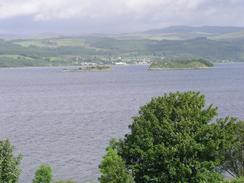
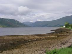
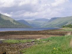
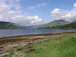
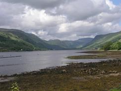
Over the last eight months I have become rather desensitised to scenery; views that would make most people go 'wow!' seem normal to me. I have seen so much wonderful scenery on this walk it all seems rather normal. Today, however, there were some lovely views up Loch Fyne, and in particular there was one place when I got an absolutely superb view up towards the top of the loch, with the sun glistening on the water and a framing of mountains. It is the sort of view that makes even the most hardened walker stop and just stare, and this was the case with me.
This evening my parents met us outside the Loch Fyne Oysters restaurant so that we could go in for a meal. This is the last time that we will be seeing them until I finish the walk, and so it was nice to spend an evening with them The food was fantastic, and Sam was in seafood heaven. I came out fully stuffed, and we waddled around the shop and bought some more food. I can fully recommend this restaurant, and we both would like to come her again some other time
Directions
This walk starts off at Lephinmore Farm, on the B8000 road between Otter Ferry and Lachlan Castle. Head northeastwards along the road as it passes Castle Lachlan, Garbhallt and on onwards until it eventually reaches the A886 road. Turn left to head northeastwards along this road for a few miles until a junction with the A815 is reached in Clachan Strachur.
Turn left and head northwards along the A815; at Creggans it starts a slow turn to head northeastwards. From Arndagowan onwards there are the remains of an old road to the left nearer the loch that gives a quieter and easier walk before it eventually rejoins the road. There is a similar one near Creag a'Phuill, and this again rejoins the A815 before St Catherines is reached. Head through St Catherines and when the road starts to climb head down a track to the left.
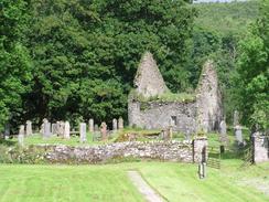
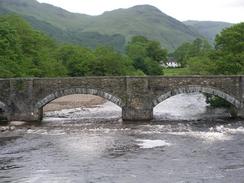
This track skirts the side of the loch past Tighcladich and heads onwards; at Rubha No it has been eroded slightly and I had to walk along the foreshore for a short distance before clambering up to rejoin the path. Continue on northeastwards beside the loch, passing Ardkinglas House and reaching the buildings of a fish farm. Here turn right and head southeastwards towards a footbridge over Kinglas Water. Cross the bridge and on the other side climb up to meet a road in Carindow. Turn left and walk northeastwards past the lovely octagonal church to the war memorial in the village, where the road meets the A83(T). Continue straight on along the A83(T) past Glaschoine and cross the bridge over the River Fyne, and a short distance further on the right at Clachan is Loch Fyne Oysters, where this walk ends.
Distances
| From | To | Distance (m) | Ascent (ft) | Descent (ft) |
|---|---|---|---|---|
| Lephinmore | Clachan Strachur | 9.4 | 617 | 669 |
| Clachan Strachur | Clachan | 10.8 | 630 | 633 |
This makes a total distance of 20.2 miles, with 1247 feet of ascent and 1302 feet of descent.
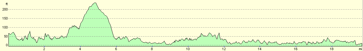
For more information on profiles, ascents and descents, see this page
Accommodation
We spent the night in the car park of Loch Fyne Oysters, who kindly let us stay there for the night.
Disclaimer
Please note that I take no responsibility for anything that may happen when following these directions. If you intend to follow this route, then please use the relevant maps and check the route out before you go out. As always when walking, use common sense and you should be fine.
If you find any information on any of these routes that is inaccurate, or you wish to add anything, then please email me.
All images on this site are © of the author. Any reproduction, retransmissions, or republication of all or part of any document found on this site is expressly prohibited, unless the author has explicitly granted its prior written consent to so reproduce, retransmit, or republish the material. All other rights reserved.
Although this site includes links providing convenient direct access to other Internet sites, I do not endorse, approve, certify or make warranties or representations as to the accuracy of the information on these sites.
And finally, enjoy your walking!
This walk was mentioned in the following routes:
| My walk around the coastline of Britain |
Nearby walks
| # | Title | Walk length (miles) |
|---|---|---|
| 463 | Ardgartan to Carrick Castle | 17.4 |
| 467 | Auchenbreck Burn to Ardlamont Point | 17.1 |
| 468 | Ardlamont Point to Lephinmore | 21.0 |
|
|

|