Walk #470: Clachan to Furnace
 |
 |
|
General Data
| Date Walked | 12/06/2003 |
| County | Strathclyde |
| Start Location | Clachan |
| End Location | Furnace |
| Start time | 09.38 |
| End time | 16.05 |
| Distance | 16.4 miles |
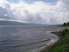
| Description | This was the shortest walk that I have done for some time, but it did have some lovely views available over Loch Fyne. |
| Pack | Today I carried my 30-litre Karrimor HotRock rucksack, which was filled with my packed lunch, waterproof leggings, water bottle and a couple of spare shirts, together with the usual assortment of odds and ends. |
| Condition | The underside of my left foot still ached this morning, and so I decided to wear my boots today instead of my trainers to see if this would hep. My feet did not hurt me as much as they did yesterday, which was nice, and the only other major problem that I had was with my legs, which felt leaden all afternoon. |
| Weather | Today was very much a day of sunshine and showers, with the latter being short in duration but very heavy at times. There was not much wind, but the sunny periods managed to dry me out quickly enough. |
| OS map | Landranger number 56 (Loch Lomond & Inveraray) and Landranger number 55 (Lochgilphead & Loch Awe) |
 |
 |
|
 |
 |
|
Map of the walk
Maps courtesy of Google Maps. Route for indicative purposes only, and may have been plotted after the walk. Please let me have comments on what you think of this new format. For a detailed table of timings for this walk, please see the table file.
Notes
This was the shortest day that I have walked for some time, and I wanted to have a short day as when I woke up this morning the underside of my left foot was still hurting. Instead of pushing myself and so a long day, I decided to follow my schedule, which stated a sixteen mile day for today. At the beginning of the trip I would have been very pleased with a sixteen mile day as it was the average distance that I had planned to do; it is a sign of how much fitter I am that sixteen miles seems like an unfeasibly short day.
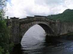
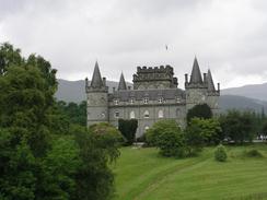
The initial part of the walk was a long eight mile slog along the A83(T) to Inverary. The road was not too busy, but despite this it was not the best walk. Trees obscured most potential views down the loch, and the roar of lorries rushing past me disturbed my thoughts. The only good things about the walk were the two spectacular bridges on this, an old military road; the one near Dubh Loch has now been bypassed, but the arched bridge outside Inverary Castle is still in use. This is quite narrow and has lights controlling the traffic, and it was quite strange to see lorries going up the steep slope towards it. I paused at the top of the bridge and took photographs of Inverary Castle, and I was slightly disappointed by it. It looks very much like a continental and not a Scottish castle, which belies its construction date. Just outside the castle I came across my first road sign mentioning Fort William, a nice sight even though I have a long way to walk to get there.
Sam met me in Inverary, and I instantly fell in love with this little town. It really is quite beautiful, and we had a little look around before we went into Mervan to have lunch. The car park was nearly full with campervans and coaches, and it appears that Inverary is on a touring route around western Scotland. After lunch we had another look around the town and visited a few shops (unfortunately I did not go into the Loch Fyne Whisky shop, as I would never have come out again!). With hindsight I wish that I had explored the town more, especially as I ended up doing such a short walk, and it is somewhere that I am going to have to visit again after the trip.
It is amazing how much I ran out of energy this afternoon - the meal last night, whilst being absolutely lovely, was quite small, and this morning I did not have any breakfast. As a result of this for the first time in ages my energy levels were at zero, and this made progress hard. It also made me quite depressed, and I was in a low funk as I walked along the tracks beside the loch. When I passed the animal farm near Dalchenna I even felt like crying - there was no reason for me to be depressed, and I can only put it down to low blood sugar levels. Unfortunately I did not take any extra food with me (I used to make sure that I had a couple of Snickers with me to eat in such situations, but these have long since been eaten).
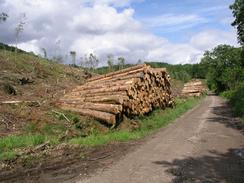
Towards the end of the walk I came across an area of hillside that was being cleared of the forest. A machine was cutting down the trees and stripping them of branches, whilst a little further down the track a lorry was being loaded with logs. The lorry took up the whole width of the track and there was not really a way to get around it. I could not make my presence known to the driver of the grab, and I was loath to squeeze past the lorry when log were being dropped into it. After a couple of minutes I got bored with waiting, and so I waited for the grab to go onto the log pile and quickly walked past it.
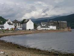
This evening we went into the local pub, the Furnace Inn, which is a short distance up the road from where we had parked. The people in the pub were very nice and we got some nice donations, and it also served a great pint. There was a pool table in the pub and so we played our first game in weeks, but whilst we were doing this we discovered that the pub had email access and so I spent a pleasant hour answering emails - I had not had the opportunity to do this for some time, and it was nice to be able to use the Internet.
Tomorrow I am in a slight quandary - ideally I would like to end a walk at Tarbert, so that I can do what appears might be a hard walk south across the hills from there to Skipness at the start of a day. This means that I will either have a very long day, or two quite short, sub fourteen mile, days. Normally this would be an anathema to me, but having a couple of short days may allow me to relax a bit and may allow the little injuries I have on my body heal themselves. For over three weeks I have been averaging twenty miles a day, so a few short days will not affect my schedule to much.
Directions
This walk starts off in the car park of Loch Fyne Oysters in Clachan. The first parts of the walk follows the A83(T) road southwestwards along the short of Loch Fyne and then around Loch Shira, a total distance of eight miles bringing you to the village of Inveraray. The road is fairly busy but there are some wide verges, so I did not feel that it was too dangerous.
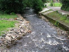
Follow the A83(T) through the town, and out on the southern side past Newtown Bay and then on through Newtown itself. Continue on southwestwards for about a mile, until a track leads off to the left. This track passes a wildlife park and continues on along the side of the loch to a caravan park. Follow the track through the caravan park to a bridge over Douglas Water, and on the other side turn to the left and follow a forestry track that passes Rubha nam Frangach before the track rises up through the woodland past Kenmore. The track descends through Pennymore and passes a quarry on the right before joining a public road in Furnace. Continue along this road and when a bridge over Leacann Water is reached cross it and turn slightly to the left to walk through the village. This walk end at the Furnace Inn in the village.
Distances
| From | To | Distance (m) | Ascent (ft) | Descent (ft) |
|---|---|---|---|---|
| Clachan | Inveraray | 8.2 | 443 | 440 |
| Inveraray | Furnace | 8.2 | 643 | 623 |
This makes a total distance of 16.4 miles, with 1086 feet of ascent and 1063 feet of descent.
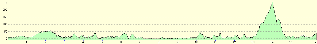
For more information on profiles, ascents and descents, see this page
Accommodation
We parked Mervan in a car park in the village of Furnace, next to the post office and a few yards down the road from the excellent Furnace Inn, which had all the facilities that we needed.
Disclaimer
Please note that I take no responsibility for anything that may happen when following these directions. If you intend to follow this route, then please use the relevant maps and check the route out before you go out. As always when walking, use common sense and you should be fine.
If you find any information on any of these routes that is inaccurate, or you wish to add anything, then please email me.
All images on this site are © of the author. Any reproduction, retransmissions, or republication of all or part of any document found on this site is expressly prohibited, unless the author has explicitly granted its prior written consent to so reproduce, retransmit, or republish the material. All other rights reserved.
Although this site includes links providing convenient direct access to other Internet sites, I do not endorse, approve, certify or make warranties or representations as to the accuracy of the information on these sites.
And finally, enjoy your walking!
This walk was mentioned in the following routes:
| My walk around the coastline of Britain |
Nearby walks
| # | Title | Walk length (miles) |
|---|---|---|
| 463 | Ardgartan to Carrick Castle | 17.4 |
| 469 | Lephinmore to Clachan | 20.2 |
|
|

|