Walk #471: Furnace to Lochgilphead
 |
 |
|
General Data
| Date Walked | 13/06/2003 |
| County | Strathclyde |
| Start Location | Furnace |
| End Location | Lochgilphead |
| Start time | 09.18 |
| End time | 15.46 |
| Distance | 17.4 miles |
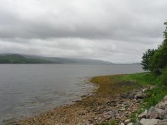
| Description | This was a long plod, mostly along roads but with some sections of tracks. |
| Pack | Today I carried my 30-litre Karrimor HotRock rucksack, which was filled with my packed lunch, waterproof leggings, water bottle and a couple of spare shirts, together with the usual assortment of odds and ends. |
| Condition | Both of my feet were aching after this walk, and in particular my left foot felt as though it was on fire. As soon as I took my boots off I was fine, however, and so I am not too worried. |
| Weather | This morning was the coldest morning for some time, and it took me a few minutes of brisk walking to warm up. It had been raining for much of the night, but fortunately this did not continue into the morning. At times it was quite bright and sunny, but when the clouds came overhead and I was exposed to the wind it was quite chilly. |
| OS map | Landranger number 55 (Lochgilphead & Loch Awe) |
 |
 |
|
 |
 |
|
Map of the walk
Maps courtesy of Google Maps. Route for indicative purposes only, and may have been plotted after the walk. Please let me have comments on what you think of this new format. For a detailed table of timings for this walk, please see the table file.
Notes
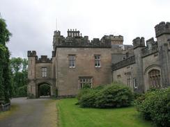
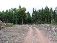
I had intended to take a more coastal walk from Minard to Brainport Bay, but just as I was nearing the turning I received a phone call from Graham, and I got so absorbed by the chat that I continued on along the A83(T) and totally missed the turning for the path. I climbed uphill towards Tullochgorm, and then found a good track that headed off downhill through the woodland towards Minard Castle. It was well worth the diversion to see the castle, as it looked absolutely superb - a proper castle, unlike Inverary castle that I saw yesterday, which was far more continental in style. I have not been able to find out any information about Minard Castle, and I do not know if it is a private residence - it certainly did not look as though it was open to the public. I walked all around the castle and took a few photographs before heading back to the track. Thus eventually brought me back to the A83(T) via Sron-na-Bruic, which was not a bad little walk.
By the time that I reached Lochgair I was in need of a rest, and so I decided to find somewhere that I could have a drink. I saw a sign for the Lochgair Hotel, and it seemed just as good as anywhere to go into. Just before I reached the hotel I saw an old man using a scythe to cut some grass, the first time that I have seen a scythe being used for years. It was a lovely sight, and it is strange that one little thing like this could put me in a good mood for the rest of the day. The hotel was very nice, and I had a nice chat to the owner. A couple of the rooms have ornate wooden panels, and apparently these are from a nearby stately home that got demolished. Whilst I was drinking my pint a Scottish couple came in, and we chatted for a while as well. Everyone I have met recently has been so friendly, and this really makes me feel good.
The afternoon involved yet more road walking along the A83(T), and this proved to be quite hard on my feet once again. My left foot in particular was hurting a great deal when I finally plodded into Lochgilphead, and the first thing that I wanted to do was to shrug off my rucksack and take my boots off. I was later than I had been expecting, however, and so I had to hurry to a local newspaper office for an interview and a photograph. When I was standing still my feet did not hurt too badly, but after this I had to walk back to the van. I must admit that I was not that impressed by Lochgilphead - it is a sprawling little town that could be very nice, but when it is compared with Inverary it does not hold itself up very well. It is almost as if Inverary knows exactly what it is and sets itself up to get the most out of that - it is almost as though it is themed. Unfortunately this is not the case with Lochgilphead, which seems to me to be aimless.
I am starting to get concerned with the state of my feet, which have been quite ropey for the last few days. They are both suffering, but in particular the underside of my left one is quite sore. For the last couple of days I have been spraying them with Ralgex, but that does not appear to have been making much difference. It really does not make much difference if I wear boots or trainers, so I cannot really think of anything else that I can do except hope that it gets better - I really do not want to take a day off unless I really need to. I have been in the fortunate situation that many of the little, niggling injuries that I have had on this walk have healed themselves through walking, the only one that I have had to take time off for is when I twisted my right ankle in Cumbria.
Tomorrow I have a relatively short road walk to do down to Tarbert. I have now decided to walk around Arran in a couple of days, and so the day after tomorrow I will have to walk to Claonaig so that I can get the ferry over to Lochranza on the isle. This will be the first time that I will have camped out on this trip, so tonight we packed up my large rucksack with all my camping gear (and enough food to last four days). I shall carry this tomorrow for the fourteen miles to Tarbert to get myself accustomed to the extra weight, and then I shall be using it for real. I am slightly nervous about camping out because I have not camped out for over a year, which is rather a silly feeling but one that I have nonetheless.
Directions
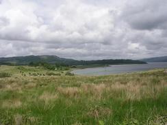
This walk starts off at the Furnace Inn in the village of Furnace. Head through the village westwards for a short distance until the A83(T) road is reached, and then continue southwestwards along the A83(T) through the village of Minard and on uphill into Tullochgorm. Immediately by the sign welcoming you to the village turn left down a track that leads towards Minard Castle. After about a kilometre there is a track junction; turning left takes you to look around the castle, and continuing straight on leads past Sron-na-Bruic back to the A83(T). When the A83(T) is reached continue straight on along the road southwestwards past Ardcastle Wood and then southwards through the village of Lochgair. The rest of the walk is along the A83(T), as it heads through Port Ann before turning to head westward and then northwestwards into Lochgilphead. This walk ends by the tourist information office in the town, which is on the A83(T).
Distances
| From | To | Distance (m) | Ascent (ft) | Descent (ft) |
|---|---|---|---|---|
| Furnace | Lochgair | 10.0 | 755 | 745 |
| Lochgair | Lochgilphead | 7.4 | 476 | 518 |
This makes a total distance of 17.4 miles, with 1231 feet of ascent and 1263 feet of descent.
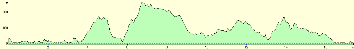
For more information on profiles, ascents and descents, see this page
Accommodation
We parked Mervan on a street in Lochgilphead, which was handy for the local pubs, but unfortunately did not have very good television reception.
Disclaimer
Please note that I take no responsibility for anything that may happen when following these directions. If you intend to follow this route, then please use the relevant maps and check the route out before you go out. As always when walking, use common sense and you should be fine.
If you find any information on any of these routes that is inaccurate, or you wish to add anything, then please email me.
All images on this site are © of the author. Any reproduction, retransmissions, or republication of all or part of any document found on this site is expressly prohibited, unless the author has explicitly granted its prior written consent to so reproduce, retransmit, or republish the material. All other rights reserved.
Although this site includes links providing convenient direct access to other Internet sites, I do not endorse, approve, certify or make warranties or representations as to the accuracy of the information on these sites.
And finally, enjoy your walking!
This walk was mentioned in the following routes:
| My walk around the coastline of Britain |
Nearby walks
| # | Title | Walk length (miles) |
|---|---|---|
| 468 | Ardlamont Point to Lephinmore | 21.0 |
| 469 | Lephinmore to Clachan | 20.2 |
| 470 | Clachan to Furnace | 16.4 |
|
|

|