Walk #522: Rhiconich to Sandwood Bay
 |
 |
|
General Data
| Date Walked | 08/08/2003 |
| County | Highlands |
| Start Location | Rhiconich |
| End Location | Sandwood Bay |
| Start time | 07.46 |
| End time | 13.03 |
| Distance | 12.5 miles |
| Description | >This was a very enjoyable walk of two halves; an initial road walk along the southern side of Loch Inchard which was followed by a nice walk up to Sandwood Bay. |
| Pack | For the first part of today's walk I carried my 30-litre Karrimor HotRock rucksack, which was filled with my packed lunch, waterproof leggings, water bottle and a couple of spare shirts, together with the usual assortment of odds and ends. At Blairmore I changed over to carrying my 70-litre Craghoppers rucksack, with nearly full camping kit in. The exception was that I did not carry the tent, and carried a bivvy bag instead. As well as this I had two days food and I carried four litres of water. |
| Condition | I feel absolutely fine after this walk, and have no problems to report. My neck and shoulder were fine despite carrying a heavier load than usual for the last four miles. |
| Weather | Today's weather was absolutely superb; bright sunshine lasted all day with scarcely a cloud to be seen. As a result of this it got quite hot, and the little breeze that there was proved to be very welcome. |
| OS map | Landranger number 9 (Cape Wrath, Durness & Scourie) |
 |
 |
|
 |
 |
|
Map of the walk
Maps courtesy of Google Maps. Route for indicative purposes only, and may have been plotted after the walk. Please let me have comments on what you think of this new format. For a detailed table of timings for this walk, please see the table file.
 |
Notes
Sam and I wanted to spend as much time as possible at Sandwood Bay, and so we knew that an early start was the order of the day. The midges were biting as I set off, but the sun was shining brightly over Loch Inchard, making a beautiful early morning sight. I could tell that it was going to be a hot day, so the early start also allowed me to get a few miles under my belt before it got too hot.
I nipped into a little shop beside the B801, which is apparently the most northwesterly shop on the mainland, to buy a couple of bars of chocolate - a little extra fuel for the next couple of days. The rest of the walk to Kinlochbervie was exceedingly straightforward, except for a man in front of me who looked more than a little drunk as he staggered from one side of the road to the other. This was quite amusing to watch, and I started to count the number of times he crossed the road - I gave up at over twenty in under half a mile walked!
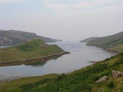
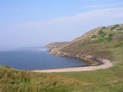
I was tempted to go down and walk along the beach at Oldhoremore, but I resisted the temptation and instead walked along the road to the car park, where Sam was waiting for me in Mervan. The track to Sandwood Bay was full of people and this made me slightly despondent - I had really been hoping that it would not be busy and that we would have the place to ourselves. This is a selfish thought, but the place is so beautiful it is a shame to have it spoilt by having hundreds of people there (as it is I need not have bothered - although there were seven or eight different groups camping out overnight, we were all scattered around the long bay at wide spacings). I needed a little rest but Sam was impatient to head off, so we set off on the long track that leads northwards to the bay. The going was easier than I remembered from my last trip, despite my shoulders having to get used to the heavier pack that I was carrying, having changed over to it at Blairmore. The lochs on the way all looked fantastic, with the water glistening in the sunshine and some small sandy beaches beside them. In one two women were swimming in the nude, seemingly oblivious to the stream of people walking past.
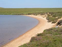
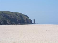
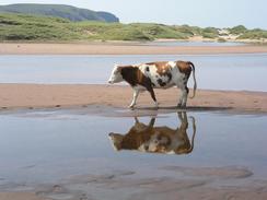
Once we arrived at Sandwood Bay we walked along the beach towards the river outfall - I was keen to spend the night at the same place I did last time I was here, as I knew it was a good pace to camp and, most importantly, I knew where we could get a decent water supply from. Sam found the walk along the beach hard, and so eventually she dropped off her pack and I made two return trips; one to take her pack and another to take mine. We soon had the tent inner up, and we then went for a little paddle in the sea. Whilst I would not call it warm it certainly was not cold, and whilst Sam swam around for a short period I was happy paddling up to my waist. At one point I nearly trod on a flatfish that was camouflaged in the sand, and got a nip on my big toe for my troubles. Sandwood Bay is a truly beautiful place, and I am so glad that I could show Sam its wonders.
Tomorrow will be my last day on the west coast, as Cape Wrath is the place where I change from the west to the north coasts. I have been on the west coast of Britain for over six months, which is such a long time that anything before Land's End seems like a distant, faded memory. The walk to the cape holds no fears for me as I have done it before, although I may try to take a slightly more coastal route if I can.
Directions
This walks starts off at the Rhiconich Hotel, on the A838 road. Leave the hotel and turn right to follow the A838 northeastwards for about a hundred yards. When the junction with the B801 is reached turn left and follow the B801 as it starts to head northwestwards along the eastern side of Loch Inchard.
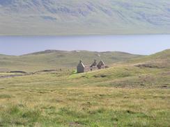
Follow the B801 as it climbs and descends as it follows the side of the loch, passing Achriesgill, Inshegra and Badcall (where there is a shop) before descending down to the war memorial beside the Loch Innis na Ba Buidhe, beside which there is a war memorial in a lovely setting. The road then continues on westwards for a short distance into Kinlochbervie passing the harbour.
Shortly after the harbour turn right to head northwards along a road which passes the hotel before meeting the northwestern shore of Loch Innis na Ba Buidhe, which is shortly followed by a council highways depot on the right. At the top of the hill the road starts to descend northwestwards past Loch na Larach before reaching a road junction in Oldshoremore.
At the junction turn right to head northwards and descend to cross a stream by a bridge. The road then starts to climb uphill and head northwestwards to another road junction to the left, which leads to Oldshore Beg. Do not take the road to the left but continue on to the right, to head northwards and then westwards into the tiny hamlet of Blairmore.
Just before a little car park is reached a track leads off to the right. This car park was created by the John Muir Trust who own the land around Sandwood Bay, and is used to stop people driving up the track towards the Bay. The track heads northwestwards through a gate, passing to the west of Loch Aisir and then the right of Loch na Gainimh. The track is fairly distinct and well formed at this time, and it is easy to follow the path as it turns to head northwards.
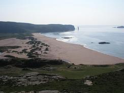
On the way northwards to Loch a' Mhuilinn the track slowly becomes rougher and more rocky. When the track reaches the eastern shore of the loch it finally ends and the way onwards becomes a path. As it leaves the shore of the loch it slowly starts to turn to head northeastwards and then eastwards, passing the two lochs of Loch Meadhonach and Loch Clais nan Coinneal. It skirts the southeastern flank of Druim na Buainn before swinging northwards and descending down to the beach at Sandwood Bay.
The next job is to find somewhere to camp in the area around the bay. Where the path meets the beach there are some dunes which could easily be camped in; I chose to camp on the northeastern side of the Bay, just across the river which flows from the loch into the sea. When I was there the stony bed of the river had been rearranged to make a little causeway across the river in one location, which allowed you to get across whilst keeping my feet dry.
This route is mentioned in the excellent book "North to the Cape", by Denis Brook and Phil Hinchliffe, Published by Cicerone Press, and ISBN 1-85284-285-7.
Distances
| From | To | Distance (m) | Ascent (ft) | Descent (ft) |
|---|---|---|---|---|
| Rhiconich | Kinlochbervie | 4.5 | 853 | 856 |
| Kinlochbervie | Blairmore | 3.3 | 587 | 390 |
| Blairmore | Sandwood Bay | 4.7 | 272 | 528 |
This makes a total distance of 12.5 miles, with 1712 feet of ascent and 1774 feet of descent.
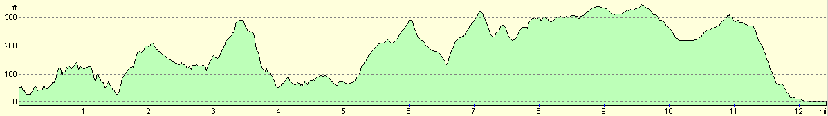
For more information on profiles, ascents and descents, see this page
Accommodation
We stayed in my tent at the north-eastern end of Sandwood Loch, at NC 2260 6517. This was a lovely spot for a campsite, and was far enough away from the beach for the sound of the waves not to disturb us.
Disclaimer
Please note that I take no responsibility for anything that may happen when following these directions. If you intend to follow this route, then please use the relevant maps and check the route out before you go out. As always when walking, use common sense and you should be fine.
If you find any information on any of these routes that is inaccurate, or you wish to add anything, then please email me.
All images on this site are © of the author. Any reproduction, retransmissions, or republication of all or part of any document found on this site is expressly prohibited, unless the author has explicitly granted its prior written consent to so reproduce, retransmit, or republish the material. All other rights reserved.
Although this site includes links providing convenient direct access to other Internet sites, I do not endorse, approve, certify or make warranties or representations as to the accuracy of the information on these sites.
And finally, enjoy your walking!
This walk was mentioned in the following routes:
| My walk around the coastline of Britain |
Nearby walks
| # | Title | Walk length (miles) |
|---|---|---|
| 200 | Scouriemore to Rhiconich | 11.0 |
| 201 | Rhiconich to Sandwood Bay | 12.8 |
| 202 | Sandwood Bay to Cape Wrath | 7.7 |
|
|

|