Walk #410: Llanfachraeth to Cemaes
 |
 |
|
General Data
| Date Walked | 10/04/2003 |
| County | Anglesey |
| Start Location | Llanfachraeth |
| End Location | Cemaes |
| Start time | 07.30 |
| End time | 17.20 |
| Distance | 18.2 miles |
| Description | This was a very scenic day over some rough and ready footpaths. |
| Pack | Today I carried my 30-litre Karrimor HotRock rucksack, which was filled with my packed lunch, waterproof leggings, water bottle and a couple of spare shirts, together with the usual assortment of odds and ends. |
| Condition | I feel worse today than I have for some time after a walk. I had a little and not very serious incident, but this led to my left ankle and knee aching more than previously. Aside from this I had no major problems, although these were more than enough for me. |
| Weather | Today was yet another sunny day, but this was let down by a stiff and cold breeze that was blowing off the sea all day. There were few clouds in the sky, but despite this I had to wear my fleece all day due to the wind. |
| OS map | Landranger number 114 (Anglesey) |
 |
 |
|
 |
Map of the walk
Maps courtesy of Google Maps. Route for indicative purposes only, and may have been plotted after the walk. Please let me have comments on what you think of this new format. For a detailed table of timings for this walk, please see the table file.
Notes
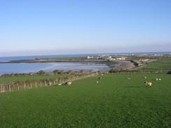
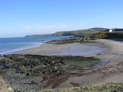
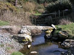
I had a very early start today, especially when compared to the rather late starts that have become a too frequent an occurrence recently. It was a bitterly cold morning, but the sun was shining and after walking for ten minutes I started to warm up and really enjoy the walk. This first part of the walk was lovely, and although I had to reach Church Bay by ten I revelled in the scenery and sunshine. There were some lovely cliffs and beaches, and the walk just seemed to fly by. Church Bay itself is very nice, and I was well into my stride when I met Sam in the car park there, which is right beside Swtan, Anglesey's only surviving thatched house. There was some frost on sheltered areas of the ground (the first that I have seen for some time), and I enjoyed treading in it, leaving my footprints behind me. The only annoying point about this part of the walk was the state of the footpaths, as some of the new ones created for the Anglesey Coastal Footpath were not well marked.
It took us nearly forty minutes to drive from Church Bay to Moelfre where the Carriage driving was taking place, but it was well worth the effort. I have only been in a carriage once before, in Melbourne, Australia with Sam, and so the experience of being driven through the village was great - there were two carriages, one a two-wheeler and the one that Sam and myself were in was a four-wheeler. But what really made the experience superb was the people, who were all lovely. They were a real laugh, and it just reinforces my high opinion of the people who volunteer for the Riding for the Disabled Association. To come out every week to do this is a really superb effort, and we were both very appreciative for the ride. It is the first time that I have seen the carriage driving aspect of the Riding for the Disabled Association's work, and it was a shame that I could not have seen disabled people in the carriages.
The entire diversion took a little over three hours, so it was early in the afternoon when I restarted walking. Very early on I met a group of people who were creating steps up a steep slope; it felt nice to be one of the first people to use the steps. Unfortunately about half an hour later I was walking over some rough ground and my left ankle went over on a hummock of grass. I hopped sideways about five feet trying to keep my balance, and although I succeeded this also put more strain on my left knee. I was wearing trainers, and this meant that my ankle was not protected when it twisted. I hobbled on, with both my knee and ankle hurting, which made the rest of the walk less than pleasant.
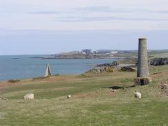
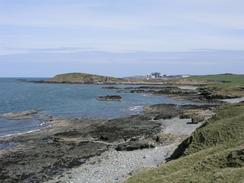
Some of the scenery around Carmel Head was very spectacular, and the views helped me to take my mind off the aches and pains coming from various parts of my body. The lighthouse on the rocks of The Skerries was flashing away, and the island looked quite sylvan in the sunshine on the flat blue sea. The shingle ridge at Cemlyn Bay was also quite picturesque, and fortunately there was a grassy path behind it that meant that I did not have to walk on the shingle. By the path behind the ridge there was a dead animal; the body was about as big as a cow's, and it appeared to have no head. It could have been the remains of a seal, but it would have been a very big one. The carcass stunk, and I took a wide diversion around it. Shortly after this I passed the Magnox nuclear power station at Wyfla, which the path has to make a big diversion around.
Tonight we went to the nearest pub, The Stag, for half an hour. Unfortunately my left ankle seized on the short walk to the pub, and so I entered with rather a hobbling gait, a peculiar entrance for a long distance walker! I used the opportunity to use the facilities, and I had a very nice pint that helped to free up my ankle, so on the way back my left knee was hurting more. This pub is the most northerly in Wales, and this fact made me think wistfully about Dunnet Head, the most northerly point in Scotland, which seems a long, long way away. This has been a very disappointing day despite some fairly stunning scenery, although the trip to see the people from the Riding for the Disabled Association group compensated for this somewhat. I can only hope that tomorrow is a better day and that I have less pain.
Directions
This walk mostly follows the Anglesey Coastal Path, a new path being created around the island. There are some laminated map sheets available from local Tourist Information offices, and there will also be a guidebook released in a few months time. There are gaps in the path that remain to be filled, and new permissive sections of footpath have been created. I found the signage on these new stretches to be inadequate or even inaccurate; then again, it is very much work in progress. I found it best to use the new route as a guide and create my own route based on it, in time this situation should improve.
This walk starts at a lay-by on the A5025 just to the south of Llanfachraeth. Turn right to walk up the A5025 northwards into the village. Pass two chapels and then turn left own another road. This road becomes a surfaced track as it heads westwards and crosses over a stream, before passing the farm at Bodlasan Fawr and reaching a beach at the coast. When the coast is reached turn right to head northwards for a few hundred yards, when a road leads off the beach to the right.
Walk up, this road for a short distance before taking a driveway that leads off to the left. Before this driveway reaches the farm at Penial Dowyn a footpath leads off to the right; I could, not find this footpath on the ground so I had to climb over a fence. The footpath heads northwestwards over a low hill before joining a track beside Porth Penrhyn-mawr.
From here a footpath runs along a track past Porth Tywyn-mawr and Trefadog, before joining a road for a short distance before a footpath leads off to the left, doing a little loop before reaching the road once more in Borthwen. A nice footpath then head northwards to Church Bay, and then onwards along the cliffs past the island at Ynys y Fydlyn before eventually reaching Carmel Head. It should be notes that part of this walk past Ynys y Fydlyn is only open from the first of February to the 14th of September. From Carmel Head another new footpath heads eastwards along the coast, passing an old chimney and two navigation markers before reaching Hen Borth and the point at Trwyn Cemlyn.
The footpath then turns to head southwards along the shingle ridge behind Cemlyn Bay until it reaches a car park at the eastern end of the ridge. The footpath then runs around the coast past Cerig Brith before heading inland to the east between Felin Gafan and Cestyll and reaching the road leading to the Wyfla nuclear power station. Turn left along this road for a short distance, passing the visitors centre before a well-marked path leads off to the right. This path winds around northwards under some power lines before turning to head eastwards and ending at a car park.
From the car park a footpath heads off to the left to head northwestwards to the western side of Wyfla Head. It then skirts the cliffs around the headland before heading eastwards past Porth Wyfla and descending into the village of Cemaes. This walk ends at a car park near the beach in the village.
Distances
| From | To | Distance (m) | Ascent (ft) | Descent (ft) |
|---|---|---|---|---|
| Llanfachraeth | Church Bay | 7.0 | 535 | 459 |
| Church Bay | Cemaes | 11.2 | 1453 | 1535 |
This makes a total distance of 18.2 miles, with 1988 feet of ascent and 1994 feet of descent.
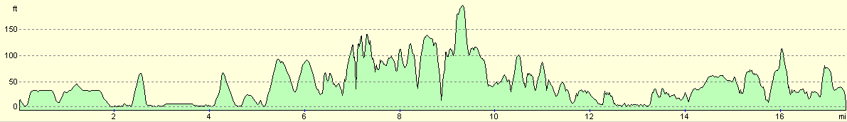
For more information on profiles, ascents and descents, see this page
Accommodation
We spent the night in a little car park near the beach in Cemaes, which was only a short stroll from the local pub.
Pictures from the carriage driving in Moelfre
Disclaimer
Please note that I take no responsibility for anything that may happen when following these directions. If you intend to follow this route, then please use the relevant maps and check the route out before you go out. As always when walking, use common sense and you should be fine.
If you find any information on any of these routes that is inaccurate, or you wish to add anything, then please email me.
All images on this site are © of the author. Any reproduction, retransmissions, or republication of all or part of any document found on this site is expressly prohibited, unless the author has explicitly granted its prior written consent to so reproduce, retransmit, or republish the material. All other rights reserved.
Although this site includes links providing convenient direct access to other Internet sites, I do not endorse, approve, certify or make warranties or representations as to the accuracy of the information on these sites.
And finally, enjoy your walking!
This walk was mentioned in the following routes:
| My walk around the coastline of Britain |
Nearby walks
| # | Title | Walk length (miles) |
|---|---|---|
| 408 | Aberffraw to Trearddur | 19.3 |
| 409 | Trearddu to Llanfachaeth | 19.0 |
| 411 | Cemaes to Moelfre | 19.1 |
|
|

|