Walk #411: Cemaes to Moelfre
 |
 |
|
General Data
| Date Walked | 11/04/2003 |
| County | Anglesey |
| Start Location | Cemaes |
| End Location | Moelfre |
| Start time | 09.18 |
| End time | 17.15 |
| Distance | 19.1 miles |
| Description | This was a highly enjoyable walk, with some great coastal scenery to be seen. |
| Pack | Today I carried my 30-litre Karrimor HotRock rucksack, which was filled with my packed lunch, waterproof leggings, water bottle and a couple of spare shirts, together with the usual assortment of odds and ends. |
| Condition | After the travails of yesterday I was okay today, with no major problems to report. Both of my ankles only gave me a couple of twinges, and my left knee was fine all day. I am amazed that my body can be so different today from yesterday, especially as the aching joints gave me an unsettled night. |
| Weather | The day started off warmer than yesterday, and the cold wind had died down so much that the sails of the wind farm had stopped turning. It was mostly sunny all day, although at times clouds rolled over and I got slightly chilly. All in all it was an absolutely superb day for a walk, not too warm and not too cold. |
| OS map | Landranger number 114 (Anglesey) |
 |
 |
|
 |
 |
|
Map of the walk
Maps courtesy of Google Maps. Route for indicative purposes only, and may have been plotted after the walk. Please let me have comments on what you think of this new format. For a detailed table of timings for this walk, please see the table file.
 |
Notes
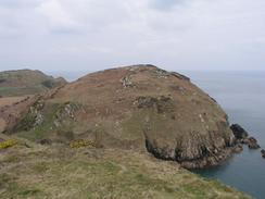
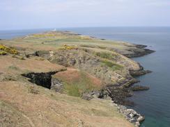
I had been told that the scenery on Anglesey was lovely, and although the first couple of days had not really live up to that promise, today did. There were many lovely sections of coastline, and the flat, calm seas and blue skies helped make this an absolutely superb walk. It should also be noted that the Anglesey Coastal Walk, which over the last few days has been hard to follow, was far better waymarked today and hence easier to follow.
I stopped at the little church at Llanbadrig to have a look around, as I had heard that it is decorated internally with an Islamic style, but unfortunately it was locked, I had a quick look around the graveyard, which had dire warnings about holes in the ground, and before I set off I met a couple who were gazing out at sea. They told me that there was a school of dolphins out to sea, and indeed there were quite a few of them swimming out to sea. I found it hard to draw myself away from the view, but they were swimming away from us and as they got further away I decided to walk on. I normally carry an ocular with me, but I did not have it today and it was a shame, as I would not have minded getting a close-up look at the dolphins.
As I was walking along to Amlwch I was listening to Radio 5 as Tom Isaacs was being interviewed. He was only four hundred yards from the end of his walk, and it was great to think that he has finally ended his odyssey. It led me to wonder how I will feel at the end of my walk - I find the thought of finishing the walk to be overwhelming at the moment, so goodness knows how I will feel when I actually reach Edinburgh. Tom's achievement is incredible, and I wish him all the best in the London Marathon, which he shall be running on Sunday.
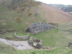
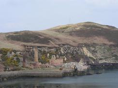
Sam was waiting for me near Amlwch Harbour, and I met her in a nearby pub, the Liverpool Arms. As I was trying to take it easy today and not push myself too hard, we stayed in the pub for a while, watching an antiques program on the television as we chatted. I really do not think hat I got to see the best parts of Amlwch - the coastal path generally avoids the town and goes past a large chemical works before reaching the harbour. Amlwch has been on the television news recently, as they are draining a large lake inside Parys Mountain, a couple of miles to the south. This lake has formed inside an old copper mine, which was started in 1768 and was at one time the largest copper mine in the world, and it needed 1,000 tons of coal a day to service it. The mine has long been disused, but the workings have flooded and the dam that hold the water in is crumbling, so they have sunk a well and are slowly pumping water out. If the dam was to fail then the town would be inundated with water which, due to the mineral content, would have the acidity of battery acid. They are unsure about how much water is in the workings, as they are not very well mapped, and consequently the length of time that the pumping needs to go on for is unknown.
By the time that I was approaching Moelfre I was very tempted to walk on further to Benllech, which was not much further on. The underside of my feet was starting to ache, however, and I had done a reasonable distance for the day so I could see little benefit in walking further. I also did not want to push it too much considering how I felt at the end of yesterday's walk. It is a shame that I did not do the extra distance as it would have been good to reach that village, but I am not too devastated about it. When I reached Moelfre Sam was coming down the hill to meet me, and we both nipped into the Kinmel Arms so that I could see if the pub had any Old Tom. This is a Robinsons ale that I used to drink over ten years ago in north Derbyshire, but since I moved down south I have never seen it. As soon as I saw that the Kinmel Arms was a Robinsons pub I wanted to go in and see if they had any, and fortunately they did do. The ale was just as lovely as I remembered it, very thick and very strong, and it slipped down beautifully. It is brewed in Stockport, so whilst I am in the area I shall have to buy a crate.
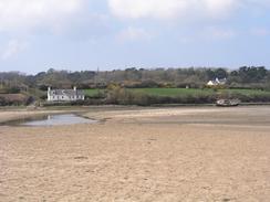
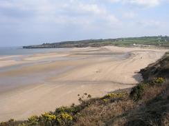
When I reached the estuary of the Afon Goch the tide was well out, and the Traeth Dulas was a large, expanse of sand with a small stream running down it. The Anglesey Coastal Path diverts inland around this area of sand, but as the tide was out I decided to walk straight across it. There were the marks from tractor tyres on the sand so I decided that it must be firm enough, and I strode across. The stream was not very deep, but because I was wearing my old boots that have lost their waterproofness my feet got damp, and I was surprised to find that the water was warm - when I have forded streams and rivers previously on this trip they have always been cold. All of the beaches on this part of the walk looked superb in the sunshine, especially Traeth Lligwy, which was a large expanse of sand.
We are staying at the campsite that we stayed at last Saturday night, and they have very kindly allowed us to stay for the night for free. They have also allowed me to have a free bath, and I spent over an hour soaking in the bath whilst I re-read John Merrill's book about his walk. I felt massively relaxed after the bath, and all my joints had stopped aching until I attempted to get out and realised that my left knee had seized!
For the last few days I have been considering taking tomorrow off, especially as rain was forecast. The rain has now moved on to Sunday or Monday, but I will still take tomorrow off. It is over a month since I last had a day off, but the main reason is that I have got plenty of work to get on with on the website. About ten days need directions writing, six days photographs need writing up and I need to alter the scripts that generate maps to avoid it putting Snowdon on the coast! Another good reason for doing this is that it will give me a chance to let my body recover from the strains it has been under - although I was okay today, I take the pain of yesterday to be very much a warning shot.
Directions
This walk mostly follows the Anglesey Coastal Path, a new path being created around the island. There are some laminated map sheets available from local Tourist Information offices, and there will also be a guidebook released in a few months time. There are gaps in the path that remain to be filled, and new permissive sections of footpath have been created. I found the signage on these new stretches to be inadequate or even inaccurate; then again, it is very much work in progress. I found it best to use the new route as a guide and create my own route based on it, in time this situation should improve. Fortunately this particular stretch of the coast path is very well signed, and therefore it is easy to follow.
The walk starts off in a car park at Cemaes. Pass the harbour and then follow the little walkway beside the seafront until it ends at another car park. A road leads northeastwards from this car park; a few yards along this road a footpath leads off to the left. From here the Anglesey Coastal Path is easy to follow all the way to Amlwch; there are frequent marker posts and direction arrows - a distinct difference to the paths on the western side of the island. The path passes to the landward side of the chemical works in the town before eventually reaching the harbour.
From the harbour in Amlwch the path is again very easy to follow eastwards towards Point Lynas and then southwards into Moelfre, where this walk ends.
Distances
| From | To | Distance (m) | Ascent (ft) | Descent (ft) |
|---|---|---|---|---|
| Cemaes | Amlwch | 8.3 | 1631 | 1588 |
| Amlwch | Moelfre | 10.8 | 1890 | 1903 |
This makes a total distance of 19.1 miles, with 3521 feet of ascent and 3491 feet of descent.
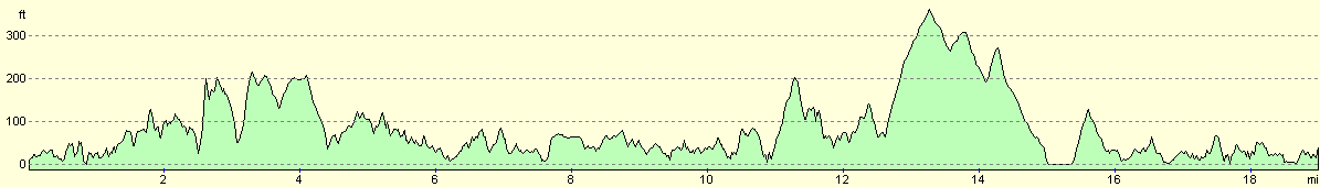
For more information on profiles, ascents and descents, see this page
Accommodation
We stayed at the excellent Home Farm Caravan Park, Marianglas, Isle of Anglesey, Gwynedd LL73 8PH, telephone (01248) 410614 or email enq@homefarm-anglesey.co.uk. They have a website at www.homefarm-anglesey.co.uk. This site was absolutely superb, and cost us ten pounds for the night. Best of all they had a bath, which for me is a totally luxurious item for a site to have. They were kind enough to give us two night's accommodation for free, which was an exceedingly kind act. This site is probably the best that we have stayed at on the entire trip, and it was well worth spending a day at.
Disclaimer
Please note that I take no responsibility for anything that may happen when following these directions. If you intend to follow this route, then please use the relevant maps and check the route out before you go out. As always when walking, use common sense and you should be fine.
If you find any information on any of these routes that is inaccurate, or you wish to add anything, then please email me.
All images on this site are © of the author. Any reproduction, retransmissions, or republication of all or part of any document found on this site is expressly prohibited, unless the author has explicitly granted its prior written consent to so reproduce, retransmit, or republish the material. All other rights reserved.
Although this site includes links providing convenient direct access to other Internet sites, I do not endorse, approve, certify or make warranties or representations as to the accuracy of the information on these sites.
And finally, enjoy your walking!
This walk was mentioned in the following routes:
| My walk around the coastline of Britain |
Nearby walks
| # | Title | Walk length (miles) |
|---|---|---|
| 410 | Llanfachraeth to Cemaes | 18.2 |
| 412 | Moelfre to Beaumaris | 18.1 |
|
|

|