Walk #777: Treforest to Cardiff
 |
 |
|
General Data
| Date Walked | 08/07/2007 |
| County | Mid Glamorgan, South Glamorgan |
| Start Location | Treforest station |
| End Location | Cardiff Central station |
| Start time | 07.15 |
| End time | 13.42 |
| Distance | 16.7 miles |
| Description | This was a surprisingly pleasant walk, partially following the Taff Trail south into the centre of Cardiff. |
| Pack | Today I carried my 30-litre Karrimor rucksack, filled with waterproofs, a book and other odds and ends. |
| Condition | My feet really ache after this walk, but aside from this I have no real problems. |
| Weather | The day was a mixture of sunshine and clouds, although the sunshine got more frequent as the day went on and the temperature increased correspondingly. |
| OS map | Landranger number 170 (Vale of Glamorgan, Rhondda & Porthcawl) and Landranger number 171 (Cardiff & Newport, Pontypool) |
 |
 |
|
 |
 |
|
Map of the walk
Maps courtesy of Google Maps. Route for indicative purposes only, and may have been plotted after the walk. Please let me have comments on what you think of this new format. For a detailed table of timings for this walk, please see the table file.
 |
 |
|
 |
 |
|
Notes
I awoke up early this morning to be greeted by sunshine, and after a half-hour lie-in in order to listen to the radio I got up and started preparing for the day's walk ahead. There were a surprising number of people up and about, including the group of Duke of Edinburgh's award scheme girls who were packing up ready for a long walk today. As I waited to fill up my water bottles I chatted to one of these before going back and packing up my tent and gear into the car, going slowly and quietly as some people were still asleep.
Eventually I could delay no longer and I shut the car boot and doors and carefully headed across the grass away from my campsite, just as the girls were shouldering their packs ready to head off. I was soon on the road and then the dual carriageway, heading down past Merthyr Tydfil towards the place where I had finished Friday's walk. Unfortunately I could not start the walk from Treforest Estate station as that is shut on Sundays, and so I was forced to start at the next station to the north, Treforest. This extended the walk that I would have to do, but as it was going to be a relatively short day this was not too much of a problem.
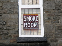
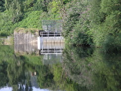
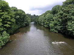
It seemed to take me an age to get to the station once I got off the dual carriageway, although it was still early as I stopped in the car park outside Treforest station and got my kit ready. The weather looked promising, and so in good heart I started the walk, heading down from the station to cross the River Taff on an old stone bridge that had a more modern decking on. The river was quite attractive and there was a large weir, but I ignored this as the road took me southwards. On Friday I had followed the Taff Trail southwards from Merthyr, and although this could take me all the way into Cardiff I decided to divert off in order to visit a county top, a few miles to the south of Treforest.
The long road walk towards Upper Boat was boring, only broken by a shop that I stopped off at to buy some refreshments, but eventually the bridge at Upper Boat was reached. I had walked across the bridge here on Friday, but as the road headed uphill I diverted away from the road leading towards the station and instead turned right just after crossing over an old railway bridge, passing under another bridge before climbing steeply uphill.
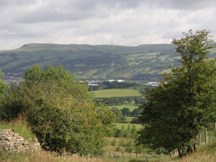
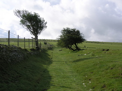
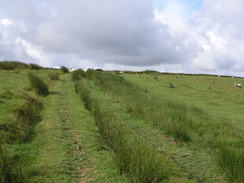
Although in place the road was steep it was a far more enjoyable walk than the previous stretch had been, and in places there were some good views of the flanks of Garth Hill, my first target for the day. The road ended and a track led uphill, and soon this was left behind as a footpath continued steeply uphill. Occasionally I would stop to admire the expansive vies back to the north, but before I knew it the gradient slackened and I passed a couple of grass-covered tumuli before approaching the trig pillar.
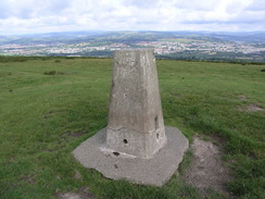
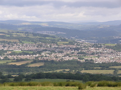
There were two cyclists by the pillar, which is situated on top of another tumulus, and as I made my way up the last climb to the pillar I was suddenly struck by some superb 360-degree views to all sides. They were particularly good to the south, where the Bristol Channel was visible past Cardiff, along with the twin islands of Steep and Flat Holme sparkling in the sunshine. Even the North Devon coast and Exmoor were clearly visible in the distance across the channel, and the views were literally breathtaking. It was by far the best of all the county tops that I had visited this weekend, and as the cyclists sped off downhill I remained alone, deep in thought.
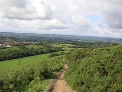
Halfway down the slope there was a man sitting on a bench admiring the view, and I stopped for a couple of minutes to have a chat with him. He lives locally and had come out for a short walk before watching the tennis later; it is one of his regular walks from his home and was a place that he said that he had loved all of his life. I could hardly blame him for this, and although I wanted to chat for longer I had to continue on. The path became a track, and on this were the two cyclists that had been at the top of the hill, stopped to repair a puncture to one of their bikes. I made some silly comment about 'tortoise and hare' before passing them; a couple of minutes later they zoomed past me. The hare had won.
The track led onto a road that headed through Soar into the village of Pentyrch. At a crossroads in the centre of the village I found it difficult to tell which road I needed to take; I ended up half-guessing and getting it right. Another road took me out of the village and headed uphill, as the road was narrow I had to walk backwards for twenty feet at one point to find a gateway to stand in when a Land Rover approached, the wing mirrors striking the hedges on either side.
Near Cefn Colstyn a track was marked on the map going downhill towards a bridge over the M4, and this was easy to find as a dark, enclosed sunken lane between two hedges. It seemed to be more of a dry stream bed than a lane, but footpath markers soon told me that I was on the correct route. The going was surprisingly rough and at one point there was a fallen tree that had to be negotiated with care, and as the lane got lower the ground underfoot started to get boggier. Fortunately there was a path through the trees to the right that allowed me to miss the worst of the boggy stretches, and before I knew it I was crossing a bridge over an old railway line to reach the bridge over the M4.
The roar of the traffic continued with me as I followed a road through Radyr, making my way to join the Taf Trail in this northwestern suburb of the Welsh capital. On the map there seemed to be what could be a bridge at the station, and as I descended I asked a couple pushing a pram who confirmed that there was indeed one, and I used this footbridge to cross the river and join the trail. By now my feet were starting to ache, a symptom of the hard walk that I had completed on Friday, and I was disappointed to find that the trail ran along a surfaced cycle path.
The trail proved easy to follow as it headed through the suburbs, at one point passing the old Melingriffith pump, a wooden water pump that used to provide water to Melingriffith tin plate works. It was nicely restored, although it was surrounded by railings that meant I could not get a closer look of this piece of industrial heritage. It seems slightly incongruous now that it is surrounded by a modern housing estate, and I can only hope that it continues to remain as a symbol of the past of the area.
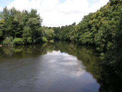
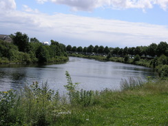
As the trail continued to wind southeastwards alongside the river the views started to become nicer, and the path busier with people out and about on this Sunday morning. In a park there were two female police officers walking slowly about, joggers, people walking dogs, cyclists, and impromptu games of football in the sunshine, a pleasant mix. Soon a stylish footbridge over the river was reached, and I used this to cross over the river, getting some good views of the weir immediately downstream. It was quite warm by now and my feet were getting into a worse state, but with a long drive still to do back to Cambridge in the afternoon I pressed on without a rest.
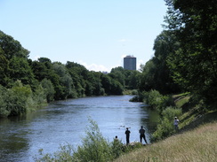
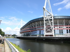
The next stretch of path led into the centre of the city, and has to be one of the most pleasant ways of entering a city that I have seen in Britain. The views over the river were superb, and I was amazed to see fishermen standing knee-deep in the middle of the river, right in the heart of the city! Everyone seemed friendly and to be enjoying themselves, and too soon I found myself crossing a road to pass by the magnificent Millennium Stadium. On the road beside this there was a busy market selling all sorts of items, and then I reached a road right by the station.
My feet were aching so much by this time that I was tempted to divert off to the station so that I could get the train back to my car. However, on my coastal walk I had walked through the Cardiff Docks and had not come this far north, so I resolved to walk down there in order to 'join up' the walks. I therefore plodded on, although the next stretch was nowhere near as pleasant as the walk into Cardiff had been. Having said that new buildings were appearing across the river, and before I knew it I was diverting off the river to walk across to the docks.
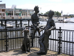
The area around the docks were bustling, just as they had been when Sam and I had taken a bot ride around the man-made harbour years before. The sun was shining, and although environmentally controversial I could not help but think how much better the new docks were than the stinking mudflats that had once been there. Cardiff Docks are becoming iconic - not the least because Doctor Who is filmed there - and I can well see why. It is a fantastic place.
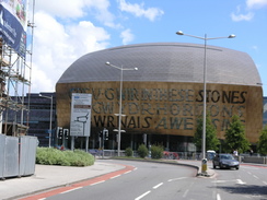
I bought an ice cream as I started heading north back towards the Central station, listening to the Grand Prix as I slowly strolled. I soon passed a station but the train had just left; the area was not as nice as the docks but not too shabby either. As I approached the centre of the city there were more well-kept, modern buildings, and an area comprising a series of fountains. It was all very nice, and I watched with interest as two men cleaned windows high up above the ground using brushes on long poles.
The station was soon reached, and I collapsed down onto a bench as I waited for my train back to Treforest. It had been a very enjoyable day's walk, albeit slightly too hard on my feet, and the journey back home also proved not to be too hard. All in all this walk was a great way to end an extended weekend in South Wales.
 |
 |
|
 |
 |
|
Directions
This walk starts off from Treforest railway station. Leave the station and turn left to head south down the access road. This soon ends at a mini roundabout; continue straight on until the road soon ends at the A473. Turn left to head north, soon passing under a railway bridge. Immediately after this turn tight down John Street. This soon ends at a T-junction; turn left down Meadow Street and follow it northwards for a short distance until it ends at Forest Road. Turn right and follow Forest Road northwards; soon a footbridge appears on the right.
The bridge ends at the A4054. Turn right to follow this southwards for nearly two miles; it passes under the A470(T) twice. When a large roundabout is met in Upper Boat, turn right to cross the river along Gwaelod-y-Garth Road. As the road curves to the left turn right down a road that heads uphill to the southwest, passing under a railway bridge. When this road ends at a T-junction at ST100864, turn left to follow this road southwards for a mile until it ends at a T-junction.
Turn right and then almost immediately left to start following a track uphill to the south towards the farm at Garth-fawr. The track passes through the farm and continues to climb up the northern flank of Garth Hill. As some open land is reached the track becomes less distinct and turns to take a more southwesterly course, cresting the summit just to the east of the trig pillar. The track becomes easier to find on the southern flank, and descends to meet a road at ST100827.
Turn right and follow this road as it curves to head southwards for a third of a mile into Pen-y-garn. As the road curves to the right, turn left down Mountain Road. When this ends turn left up Hoel y Pentre, which heads southeastwards through Pentyrch. As this road curves sharply to the right, turn left down Caerau lane. This heads southeastwards before curving to the left to head eastwards. When the road dies out at ST109815 turn right down a green lane. It descneds and curves around before settling on a southeasterly course. It meets Pant Tawel Lane end-on before crossing an old railway line and then the M4.
Pant Tawel Lane ends at a T-junction with Drysgol Road. Turn right and follow this road as it heads eastwards through Radyr. After half a mile this ends at the B4262. Turn right to head south down the B4263 and then take the first road off to the left, Windsor Crescent. This curves to the right to end at Station Road. Turn left to head down towards Radyr station. When the road curves sharply to the right continue straight on, passing under the station to reach a footbridge over the River Taff.
The Taff Trail is met on the other side; turn right to start following this as it runs along the eastern side of the river for three miles; it is well waymarked on the ground. At ST171780 I crossed the river via a footbridge above a weir. On the other side turn left to start heading south along the western bank of the river. Two and a half miles later the A4119 road is reached in Grangetown; turn left and cross the river on Clarence Bridge.
When New George Street is reached on the right, turn down it to head south for a short distance; as it curves to the right continue straight on along a pedestrianised road towards the waterfront. Explore for a little, before turning around and heading north to meet the A4119. Cross the A4119 and head straight on northward along Bute Street. This passes Cardiff Bay station on the right. Continue on until the road passes under a railway line; shortly afterwards turn left to head west to Cardiff station.
 |
Distances
| From | To | Distance (m) | Ascent (ft) | Descent (ft) |
|---|---|---|---|---|
| Treforest station | Garth Hill | 5.0 | 1001 | 177 |
| Garth Hill | Forest Farm | 3.9 | 177 | 1112 |
| Forest Farm | Cardiff Docks | 6.5 | 131 | 197 |
| Cardiff Docks | Cardiff station | 1.3 | 39 | 26 |
This makes a total distance of 16.7 miles, with 1348 feet of ascent and 1512 feet of descent.

For more information on profiles, ascents and descents, see this page
Transport
There are regular train services from Cardiff to Treforest, even on Sundays. A single ticket for this journey cost me £2.90.
Disclaimer
Please note that I take no responsibility for anything that may happen when following these directions. If you intend to follow this route, then please use the relevant maps and check the route out before you go out. As always when walking, use common sense and you should be fine.
If you find any information on any of these routes that is inaccurate, or you wish to add anything, then please email me.
All images on this site are © of the author. Any reproduction, retransmissions, or republication of all or part of any document found on this site is expressly prohibited, unless the author has explicitly granted its prior written consent to so reproduce, retransmit, or republish the material. All other rights reserved.
Although this site includes links providing convenient direct access to other Internet sites, I do not endorse, approve, certify or make warranties or representations as to the accuracy of the information on these sites.
And finally, enjoy your walking!
Nearby walks
| # | Title | Walk length (miles) |
|---|---|---|
| 372 | St Brides Wentlooge to Lavernock Point | 18.0 |
| 373 | Lavernock Point to Summerhouse Point | 15.3 |
|
|

|