Walk #800: A circular walk from Hindon to Ludwell
 |
 |
|
General Data
| Date Walked | 26/11/2007 |
| County | Wiltshire |
| Start Location | Hindon |
| End Location | Hindon |
| Start time | 08.02 |
| End time | 16.04 |
| Distance | 20.6 miles |
| Description | This was a surprisingly disappointing circular walk based on the Wessex Ridgeway in Wiltshire. |
| Pack | Today I carried my 30-litre Karrimor rucksack, filled with waterproofs, a book and other odds and ends. |
| Condition | I had a little trouble with my toes and feet on this walk, which turned out to be due to my toe nails not having been cut recently. Aside from this I had no real problems. |
| Weather | The day was grey, with no sight of the sun at any time. There was a periodic light drizzle, and at lunchtime I changed into my coat. It was not a warm day, and there was a slight breeze to chill me as I walked. |
| OS map | Landranger number 184 (Salisbury & The Plain, Amesbury) |
 |
 |
|
 |
 |
|
Map of the walk
Maps courtesy of Google Maps. Route for indicative purposes only, and may have been plotted after the walk. Please let me have comments on what you think of this new format. For a detailed table of timings for this walk, please see the table file.
 |
 |
|
 |
 |
|
Notes
I felt like walking a stretch of the Wessex Ridgeway today, so I set off on the long drive through Wiltshire to Hindon. It took me longer than I expected to reach the village, and the next problem was where to park. It was spitting with rain, and for a few brief moments I considered calling the walk off. Unusually, I parked right on the path, as the Wessex Ridgeway passes along the road. Children were waiting for their school busses, and I quickly got my gear together. Unfortunately I did this rather too quickly, and I dropped my dictaphone onto the road. The 'new file' button was smashed in, but I soon found a way to continue recording in a new file. Combined with the drizzle, it made for an inauspicious start to my 800th walk.
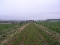
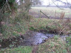
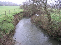
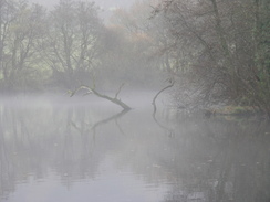
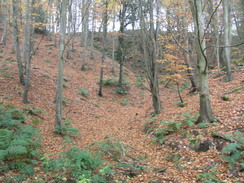
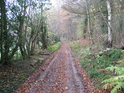
Roads took me through the village, passing a converted chapel on the way, and then a restricted byway took me westwards. There were some reasonable views to be had despite the cloudy skies. The path entered some woodland near Knoyle Corner, and by the time it emerged I fund myself surrounded by mist and low cloud. A boggy stretch of path took me alongside a stream past Summerleaze Farm, and a climb took me on to meet a road at the top of a hill. A green, uncared-for trig pillar stood nearby, and a short path took me onto a road in Newtown.
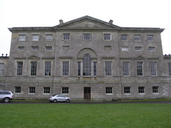
A long descent took me down to a railway line; after this it crosses the diminutive River Sem, then follows roads and tracks to reach the spectacular New Wardour Castle. The path granted me a great view of the grey Palladian frontage of the building, which was completed in 1776 to replace the original Wardour Castle.
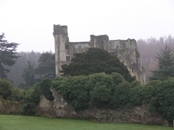
That was reached a mile and a half later, the Wessex Ridgeway taking a well-deserved loop to visit the spectacular ruins. The castle had a long history before it was finally destroyed in the civil war, having been in the hands of both the Royalists and Parliamentarian forces at various times. The resultant ruins are spectacular, with dark stone heading up into the sky. As expected, it was not open for visitors, and I climbed up a hillside to try and get some better pictures of the exterior.
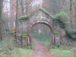
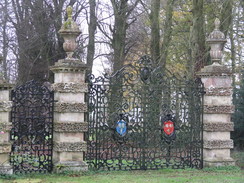
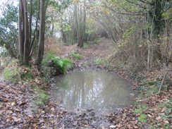
Paths took me on southwestwards, passing through an impressive stone gateway before descending to cross between two ponds. After this I found the path hard to find, and I floundered around slightly before reaching the desired road near Donhead St Andrew. A dead-end road took me to Dengrove Farm, and a rutted track then led me uphill before descending once more. A light drizzle started, which soon became heavy enough top force me to put my coat on. A combination of undistinguished roads and tracks took me on southwestwards, and just before Ludwell is reached I descended down a path to the left to reach the A30 in Ludwell.
I went into the Grove Arms for half an hour before heading out once more. It was a nice pub, and I had a pint of bitter and one of orange and lemonade. I also took my fleece off as I was getting a little warm. So far I had found the Wessex Ridgeway to be thoroughly undistinguished, and so I decided to take a different route back. Unfortunately there were not many options open to me, so I headed west up along the A30 for a short distance into Ludwell before turning off along a lane. A series of lanes took me northwards, passing through Donhead St Mary, with its pleasant-looking church. The stone used in the buildings of the village looked to be the same sort used in Old Wardour Castle; grey and old-looking. The road skirts the side of Barkers Hill before ending at a T-junction. The weather started to get worse and more drizzly. A boggy and churned-up track took me back across the River Sem and under the railway line once more.
Roads took me uphill to the north, allowing me to pass the trig pillar once again. Instead of rejoining the Wessex Ridgeway I continued on northwards along the road. Soon trees started on the right, part of the Fonthill Abbey estate. Just before this headed uphill I turned off to the left, taking a muddy track that took me westwards past Ruddlemoor Farm to reach the Wessex Way once again. Then it was simply a case of retracing my steps along the Wessex Ridgeway back towards Hindon.
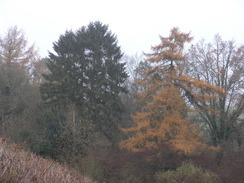
Just before I reached the village, however, I realised that I was would not be at twenty miles by the time I finished the walk. For this reason I decided to extend it by joining the Monarch's Way and following it eastwards towards the B3089. It was starting to get dark by this time, and so the journey back to the village along the winding road was not the most pleasant stroll that I have ever done. I reached my car safely, however, after a disappointing day. I had been hoping that the Wessex Ridgeway would be a good walk, something as beautiful and ridge-like as my last walk. Unfortunately, although it was hilly, there were few views to be had on this stretch. I can only hope that other stretches of the walk are better.
 |
 |
|
 |
 |
|
Directions
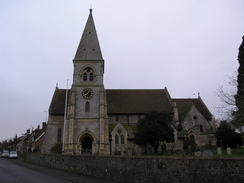
This walk starts off from Hindon Church, and followed the Wessex Ridgeway for the first half of the day. Leave the church and head downhill along the road southeastwards. When the main road through the village is reached, cross it and continue on southeastwards downhill, passing a chapel on the left. At a crossroads turn right, and then left to take a road that starts heading uphill to the southwest. Before the top of the hill is reached turn right to start walking slightly south of westwards along a green lane, following the Wessex Ridgeway.
Half a mile after leaving the road a crossroads in tracks is reached. Turn left to start heading southwestwards along a track. This heads downhill, and then starts rising. Two-thirds of a mile after the crossroads it enters some woodland. The path continues to climb steeply uphill, passing Knoyle Corner before starting to descend. It passes an old pit on the left, and then emerges out into open fields. Continue southwards, following the Wessex Ridgeway.
Half a mil after leaving the trees, turn left along a bridleway that heads slightly south of eastwards along the southern bank of a stream. It passes immediately to the north of Summerleaze Farm, and after half a mile ends at a road. Turn left to follow this road northeastwards for a couple of hundred yards, and then turn right to start heading southeastwards uphill. The path passes a pond on the right, and then enters a small band of trees before skirting the northern edge of the same trees eastwards to the top of the hill.
The path meets a road; cross the road and start walking down a short track on the other side that passes a trig pillar before ending at a gate. Go through the gate, and continue on eastwards along a bridleway that soon ends at a road. Turn right along this road, and follow it east until it ends at a T-junction in the hamlet of Newtown.
Turn right for a few yards along a road, and then take a footpath that heads off to the left. This path enters a band of trees for a short period, before leaving them and following the southern edge of the tree line southeastwards. At the end of the field after passing under some power lines, the path jinks to the right and follows the field boundary southwestwards for a short distance, before turning to the left to head southeastwards. It joins a track that passes New Barn and reaches a road.
Cross the road, and on the other side take a footpath that heads south for a short distance to end at a road,. Head straight on down this road as it crosses a railway line on a bridge, and then turn left along another footpath. This crosses the small River Sem on a footbridge and then ends at a road.
Turn left along this road for a short distance and then turn right to head uphill along another road. When it jinks sharply to the left, continue straight on along a track that heads towards Wardour Castle. Follow the track as it curves around the front of the castle, and then at the eastern end take a footpath that heads off southeastwards, with some trees as short distance away on the left. The path becomes a track, and at a junction turn left to head eastward along another track that passes Ark Farm and reaches a car park for Old Wardour Castle.
At a junction of tracks near the car park turn right, to head between a pond on the right and the curtain wall of the castle on the left. The path follows the track through the trees until the track curves up to a gateway on the left; continue straight on as the path heads southwestwards, leaving the trees and falling down to cross between Heron Pond on the right and Pale Park Pond on the left.
From the ponds the path rises once more up a field before entering an area of woodland. Slowly the path curves to the right slightly to take a more westerly course, joining a track that leaves the trees and curves to head southwestwards and end at a road. Turn left down this road through Donhead St Andrew, and after a couple of hundred yards turn right down a track.
This leads southwestwards to Dengrove Farm; after crossing a stream it curves to the left to head southwards, before turning to the right and climbing uphill southwestwards. The top of the hill is flat; it crosses a track called Green Lane and then starts descending down to meet Owerway Lane. Cross Owerway Lane, turn right for a few yard and then left to take another footpath that heads south for a short distance, dropping down to another road.
Cross the road and take a footpath that heads westwards, climbing uphill slightly before hading westwards through Lower Berrycroft Farm. Follow the path as it curves to the left to reach a road neat Mullins' Bridge. Cross this road and then take a byway that heads uphill to the southwest; near the top of the hill it passes a mast and continues on across fields. In the middle of the second field at the top of the hill turn left, to descend southeastwards to the A30 in Ludwell. Here the Wessex Ridgeway is left behind.
Turn right to head westwards along the A30, and then turn right up Front Horse Hill Lane, which heads slightly east of north for over half a mile before reaching a T-junction. Turn left to follow another road north for a few hundred yards, and then turn right along a road that passes chapel on the right before curving around to the left to head northwestwards into Donhead St Mary. Take the first road off to the left, Berry Wood Lane, which immediately passes the church on the left. Continue on this road as it heads in a rough northwards direction for about two miles before it ends at a T-junction.
At this junction continue straight on along a bridleway that heads northwards for a few hundred yards; it crosses the River Sem on a footbridge and then passes under a railway line. It then curves sharply to the right and left to resume heading northwards to end at a road. Turn right along this road to head eastwards for a short distance until it ends at a T-junction, and then turn left to start heading northwards.
After climbing for half a mile the road ends near Pythouse Farm; turn right along a new road and then immediately left to head northwards for a little over half a mile. This road heads northwards before curving to a more northeasterly course, crossing the route walked earlier in the day in the process. At a junction turn left to head north along a road for two-thirds of a mile until a track leads off to the left at ST909304, just before the road reaches some trees.
Head left along this track and follow it as it heads westwards for a mile, passing Ruddlemoor Farm and skirting the southern edge of some woodland. When a track is reached at ST897306 turn right to head up through the trees, joining the path that was walked earlier in the day, except in the opposite direction.
Follow this track as it leaves the trees, heading northeastwards, falling and then climbing to reach a crossroads in tracks. Turn right to head slightly north of east. When a road is reached, do not turn left down the hill but continue straight on along an access road that leads northeastwards to another road.
Cross this road and continue on northeastwards until the B3089 road is reached to the east of Hindon. Turn left and follow the B3089 west back towards the village for half a mile. At a crossroads in the centre turn right and climb uphill for a short distance to the church, where this walk ends.
 |
Distances
| From | To | Distance (m) | Ascent (ft) | Descent (ft) |
|---|---|---|---|---|
| Hindon | Old Wardour Castle | 7.0 | 902 | 839 |
| Old Wardour Castle | Ludwell | 4.0 | 620 | 689 |
| Ludwell | Pythouse | 4.6 | 692 | 509 |
| pythouse | Hindon | 5.0 | 394 | 571 |
This makes a total distance of 20.6 miles, with 2608 feet of ascent and 2608 feet of descent.
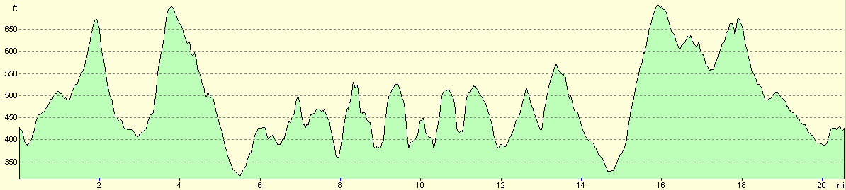
For more information on profiles, ascents and descents, see this page
Disclaimer
Please note that I take no responsibility for anything that may happen when following these directions. If you intend to follow this route, then please use the relevant maps and check the route out before you go out. As always when walking, use common sense and you should be fine.
If you find any information on any of these routes that is inaccurate, or you wish to add anything, then please email me.
All images on this site are © of the author. Any reproduction, retransmissions, or republication of all or part of any document found on this site is expressly prohibited, unless the author has explicitly granted its prior written consent to so reproduce, retransmit, or republish the material. All other rights reserved.
Although this site includes links providing convenient direct access to other Internet sites, I do not endorse, approve, certify or make warranties or representations as to the accuracy of the information on these sites.
And finally, enjoy your walking!
Nearby walks
| # | Title | Walk length (miles) |
|---|---|---|
| 790 | A circular walk from Salisbury | 24.0 |
| 799 | A circular walk from Broad Chalke to Win Green Hill | 23.0 |
| 827 | A circular walk from Coombe Bissett | 23.0 |
|
|

|