Walk #673: Braemar to Clova
 |
 |
|
General Data
| Date Walked | 15/05/2005 |
| County | Grampian, Tayside |
| Start Location | Braemar |
| End Location | Clova |
| Start time | 07.49 |
| End time | 16.39 |
| Distance | 18.2 miles |
| Description | This was a superb walk following Jock's Road over the hills from Braemar. |
| Pack | Today I carried my 70-litre Craghoppers WildPlaces rucksack, filled with full camping gear. |
| Condition | I feel absolutely fine after this walk, which is good considering the steepness of the climb. The only problem I had is that I ran out of water about halfway through, and I had to wait for an hour to find a suitable stream to fill up from, so I was slightly dehydrated. |
| Weather | This morning was absolutely superb; few clouds in the sky. It was a very warm morning, but as the afternoon came on the clouds descended and it got cooler. There was little wind and no sign of any rain. |
| OS map | Landranger number 43 (Braemar & Blair Atholl) and Landranger number 44 (Ballater, Glen Clova & surrounding area) |
 |
 |
|
 |
 |
|
Map of the walk
Maps courtesy of Google Maps. Route for indicative purposes only, and may have been plotted after the walk. Please let me have comments on what you think of this new format. For a detailed table of timings for this walk, please see the table file.
 |
 |
|
 |
 |
|
Notes
I awoke this morning nicely refreshed after a good night's sleep, and, because of this and unusually for me, I woke up quite late. This gave me half a hour to get ready before my early breakfast, during which time I packed my rucksack, which I had unpacked fully the previous afternoon to work out my current food supplies. The breakfast was timely, filling and appetising, and after I was finished I chatted to the landlady for a while before changing into my walking clothes and taking my pack downstairs. I had been expecting to need to wear my fleece, but when I opened the door I was surprised to feel how warm it already was, so I repacked my fleece into my rucksack before shouldering the pack and heading off.
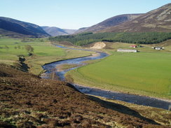
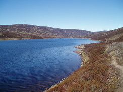
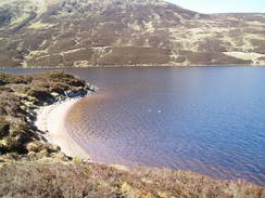
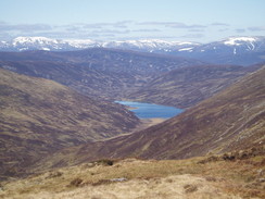
I was quite relieved to find that the main road was quiet at this early hour on a Sunday, and only a handful of cars passed me as I strolled southwards along it, admiring the views over the adjacent river. My legs were feeling just about warmed up by the time that I reached the turn-off for Callater Lodge, and I started the stroll up the track, which had a firm but uneven surface. Just before I reached the bridge over the burn I met a man walking with full pack in the opposite direction. We started chatting, and it turned out that he was from Kyleakin on Skye, and he had been walking with his son for a couple of days, who was on the challenge. They had spent the night in the bunkhouse at Callater Lodge and much alcohol was drunk, and consequently several people had not set off yet. I said goodbye and set off the track, before eventually reaching the lodge which is in a fantastic situation. The whitewashed walls shone in the morning sunshine, and by walking around to the rear I got the full effect of the beautiful loch, the sun glinting off the little wavelets.
Just before the lodge there was a sign stating 'TGO Tea', and as advertised the two gents inside were giving tea to passing challengers. I dropped my rucksack off against the whitewashed wall of the main cottage and went inside, to be greeted warmly by the two men inside. Outside a few people were milling around the walls of the bunkhouse, and it truly seemed as if a great night had been had by everyone involved. I chatted to them as I refreshed myself with a couple of glasses of orange juice, which I needed as the morning was turning out to be even warmer than I had been expecting. They told me about the condition of the path ahead, and that Prince Charles often nipped in to stay unannounced. The two owners were real characters, and I enjoyed my chat with them, especially about the locality, which has no mains power or running water. Eventually I could not dally any longer, and so I went outside, hauled my rucksack onto my back and headed off along the path.
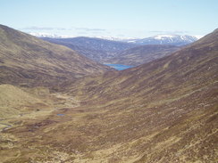
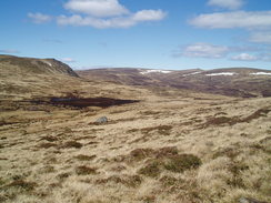
People had told me that the path alongside the loch was extremely boggy, but fortunately it had recently been improved and aside from one or two boggy patches it was absolutely fine, and there were superb views over the loch in all directions. I pushed myself on, and soon reached the end of the loch where I had been advised to keep to the left to avid the worst of the boggy ground. Naturally I ignored this advice and headed straight on over the bogy areas, and although the going was not bad it was not good either, and so I headed over to the higher ground on the left where there was, indeed, firmer ground and a faint path that could be followed. What followed was an exhilarating stroll as the path rose and fell, and as it slowly climbed increasingly expansive views could be seen behind me back towards the loch. Eventually the path reached he steep section, and the path petered out. This was by far the hardest climb of the walk so far, and I took frequent stops on my inexorable climb uphill. I was sweating profusely as I climbed, and as soon as I drunk some water I was sweating it out. I resolved to take my time, and when I finally reached the top off the steep section I turned back with satisfaction over the surrounding Munros and the snow-covered Cairngorm peaks in the distance.
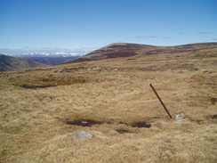
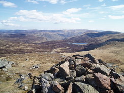
Once on the top the going was classic moorland terrain. In bad weather it would be fairly awful, but in good weather like today I was in heaven. It was a really, really, enjoyable stroll, and I walked over the Knaps of Fafernie I was in a literal and metaphorically high mood as I headed across the moorland. The good weather and terrain allowed me to make good time, and I soon turned to the right to head southeastwards towards the 920-metre summit of Crow Craigies. Just before I reached it I overtook another TGO'er, and we chatted as we reached the summit, which at a smidgen over 3,000 feet was the highest point that I had been on this trip. The views were surprised, and whilst I had an urge to go and visit some of the nearby Munro summits (which hardly involved much climbing from our height) I resisted the temptation and, regretfully, started following the path southeastwards.
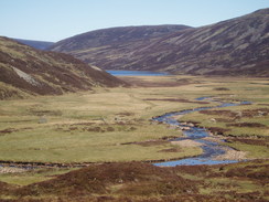
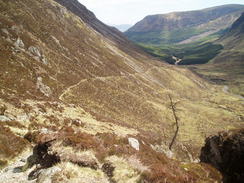
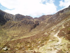
The going underfoot was good and the path easy to follow (although I can see that it would be more difficulty in bad weather), and once the path skirted under the nameless 874-metre summit I stopped to have lunch, lying down beside the path to soak up the suns rays. It was a lovely time, and I enjoyed watching a couple of walkers walking in the distance, slowly making their way up to the top of Crow Craigies. Eventually I gathered my things together and started heading off down the path, which soon became steeper and less distinct as it headed southwards near Cairn Lunkard. Here there was a memorial to five students who died in the area, and an emergency shelter, built into a rocky area of the hillside. After this the going became easier, and I soon reached the classic part of Jock's Road, the path easily visible as it hugged the northern side of the valley unfolding in front of me.
Jock's Road is renowned as it was the first Scottish Right of Way and is a famous route over for climbers and walkers between Braemar and Clova via Glen Callater. It was named after Jock Winter who challenged the landowner over the right to be on this particular route, and it is therefore fitting that it should be named in his honour. As I descended the path, which was far easier to negotiate than it appeared from a distance, I started meeting more people climbing up from Glen Doll, where there is a large car park. I chatted to a few of these as I headed down, and as the gradient eased I approached the gate that led into Glendoll Forest. By the gate I met the TGO'er whom I had chatted to on Crow Craigies, who was sitting down on the hillside by the gate, resting with boots and socks off. We had another chat, before I opened the gate and plunged along the path through the woodland. After the exhilarating walk along Jock's Road this stretch was a disappointment, and I out myself on autopilot as I headed eastwards. Before Glendoll Lodge was reached the path become a broad track, and I soon found myself near the lodge, where until recently there had been a Scottish YHA hostel - now unfortunately closed down.
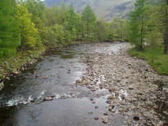
I strolled on as the track became surfaced, and soon passed the car park that was virtually full. On the map there is a campsite here but this has also closed down, so I strolled on, using the public conveniences before continuing on along the road. From here the last three miles were along a road, and although there were some superb views of the surrounding hills I found the walk quite boring, especially as the narrow road was busy with weekend traffic carrying visitors away from the hills. Just before I reached Clova Hotel I passed the ruins of Clova Castle, which seemed to consist of little more than a couple of low walls in a field beside the road. I could not get a decent photo of the ruins, so I continued on to the hotel. This was fairly busy and so I walked around the corner of the building to gain access to the Climbers Bar, where I availed myself of a pack of crisps, a pint and a can of Red Bull. These did not last long, and I soon found myself ordering another pint.
Once I had revitalised myself I left my rucksack in the bar and headed along a short corridor to reception, where I picked up the key for my room in the bunkhouse. In the reception I met the other walker, who had also booked himself in. I was lucky in that I got a bed in a double room, whilst the others were in larger rooms designed for six people. I went and settled in and had a relaxing shower, the water washing away all the stresses and strains of the day. More TGO'ers came in as the day progressed and we ended up having a superb evening, with lots of friendly chat and conversation. This really made what had been a good day complete, and I am slightly sad that from tomorrow I am going to be on a far less walked route, as the other TGO'ers are making their way over to the fabled Tarfside.
 |
 |
|
Directions
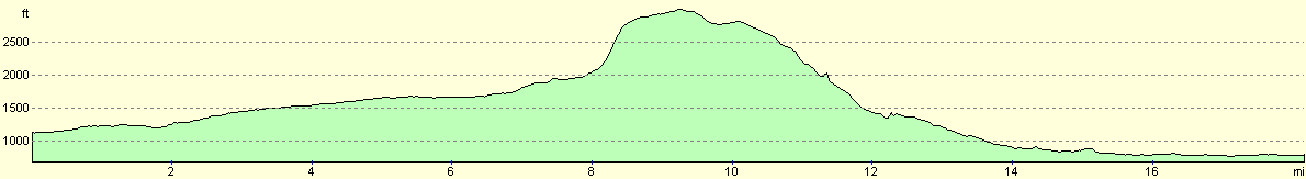
This walk starts off at the Fife Arms in the centre of Braemar. Head eastwards towards the bridge over Clunie Water, and when the road ends a hundred yards later a a junction with the A93, turn right and start following the A93 southwards for a couple of miles until the bridge over the Callater Burn is reached at Auchallater. Cross the bridge, and immediately on the other side turn left to join a track. Follow this track as it follows the Callater Burn upstream, initially sticking to the western bank before crossing the burn on a bridge and following the eastern bank onwards to the welcoming buildings at Lochcallater Lodge. Here leave the track, and push on past the buildings to join a path that skirts the northern edge of Loch Callater southeastwards. The path is very good in places, and the views over the loch superb in good weather. Once the head of the loch is reached the ground becomes boggy, and it is wise to keep to the left to avoid having to cross numerous little streams. The path is occasionally indistinct, but once the end of the boggy ground is reached it becomes increasingly distinct and firm, and in places there are signs that it has been recently improved.
The path follows the Allt an Loch southwards, climbing and falling as it gets by various obstacles. It then turns to head southeastwards as the stream becomes more of a trickle as it gets higher up Glen Callater. Eventually the path peters out (at least it did for me) below Creag Leachdach, and a high, seemingly vertical, face greets you to the left. Do not continue south along the valley, but start following the northern bank of a tributary stream southeastwards, the gradient slowly increasing. Eventually the route becomes very steep, so carefully zigzag up the hillside between two streams in an easterly direction; care needs to be taken on this section particularly. Once at the top the gradient slackens and a moorland vista greets you. Continue eastwards across the moorland towards NO217806 at Knaps of Fafernie, where the route turns to head southeastwards towards the obvious rocky summit of Crow Craigies. In bad weather this would be an extremely exposed location, so care should obviously be taken.
Once at Crow Craigies take the obvious path that heads southeastwards for about half a mile; just before another little hill is reached at NO229792 the path turns to the right to take a more southerly course, skirting the hill and heading to the west of Cairn Lunkard. The path is easy to follow, although there is a steep stretch leading down towards the emergency shelter beside the path. From here another steep section leads southeastwards downhill, before the path enters Glen Doll. From here the path is more gentle as it slowly descends down the valley side, a lovely walk with some grand vistas available. Once the path approaches the valley floor and the White Water burn it passes through a gate into Glendoll Forest. Follow the path as it heads through the woodland, joining a track as it heads eastwards towards Glendoll Lodge and Acharn. Here the track becomes surfaced, and becomes a public road as it passes a car park. Near some public conveniences the road crosses a river, and then starts to head southeastwards past Braedownie, sticking to the northern side of the River South Esk. Continue along the road for about three miles until a road junction leads off to the right; continue straight on for a few yards and the Clova Hotel is immediately on the left.
Distances
| From | To | Distance (m) | Ascent (ft) | Descent (ft) |
|---|---|---|---|---|
| Braemar | Lochcallater Lodge | 5.0 | 689 | 164 |
| Lochcallater Lodge | Crow Craigies | 4.3 | 1516 | 184 |
| Crow Craigies | Clova | 8.9 | 505 | 2703 |
This makes a total distance of 18.2 miles, with 2710 feet of ascent and 3051 feet of descent.
For more information on profiles, ascents and descents, see this page
Accommodation
I spent the night in the bunkhouse of the Glen Clova Hotel. tel. 01575 550350, which cost me ten pounds for a bed in a neat and tidy room (I had the only twin room which was only occupied by myself. I also had breakfast, which cost me five pounds and was served from eight.
Disclaimer
Please note that I take no responsibility for anything that may happen when following these directions. If you intend to follow this route, then please use the relevant maps and check the route out before you go out. As always when walking, use common sense and you should be fine.
If you find any information on any of these routes that is inaccurate, or you wish to add anything, then please email me.
All images on this site are © of the author. Any reproduction, retransmissions, or republication of all or part of any document found on this site is expressly prohibited, unless the author has explicitly granted its prior written consent to so reproduce, retransmit, or republish the material. All other rights reserved.
Although this site includes links providing convenient direct access to other Internet sites, I do not endorse, approve, certify or make warranties or representations as to the accuracy of the information on these sites.
And finally, enjoy your walking!
This walk was mentioned in the following routes:
| The Great Outdoors Challenge 2005 |
Nearby walks
| # | Title | Walk length (miles) |
|---|---|---|
| 672 | Derry Lodge to Braemar | 8.9 |
|
|

|